NATL: IMELDA - Models

Moderator: S2k Moderators

Message
Author
tolakram
Admin
Admin
Posts: 20126
Age: 62
Joined: Sun Aug 27, 2006 8:23 pm
Location: Florence, KY (name is Mark)

Re: NATL: INVEST 94L - Models

#41 Postby tolakram » Wed Sep 24, 2025 12:50 pm

jlauderdal wrote:
Magical power we have in SE Florida

Sent from my Pixel 9 using Tapatalk


Indeed, the power of complacency. I sincerely hope there's no surprises this year because this joke attitude is often taken the wrong way, as we've seen with past posters on here using diagrams and climate change to tell us why SE Florida will never be hit again. Obviously a lot of us don't think this is funny.
5 likes   
M a r k
- - - - -
Join us in chat: Storm2K Chatroom Invite. Android and IOS apps also available.

The posts in this forum are NOT official forecasts and should not be used as such. Posts are NOT endorsed by any professional institution or STORM2K.org. For official information and forecasts, please refer to NHC and NWS products.

User avatar
wzrgirl1
S2K Supporter
S2K Supporter
Posts: 1360
Joined: Sat Sep 04, 2004 6:44 am
Location: Pembroke Pines, Florida

Re: NATL: INVEST 94L - Models

#42 Postby wzrgirl1 » Wed Sep 24, 2025 12:52 pm

I agree and considering how close the Euro ensembles have this going to the coast, it wouldn't take much of a shift west to put tropical storm winds on our coast if indeed it forms into a named system.
0 likes   

BobHarlem
Category 5
Category 5
Posts: 2535
Joined: Thu Oct 20, 2005 6:11 pm

Re: NATL: INVEST 94L - Models

#43 Postby BobHarlem » Wed Sep 24, 2025 1:07 pm

12z euro is something else.

Image
9 likes   

User avatar
got ants?
Tropical Storm
Tropical Storm
Posts: 115
Age: 66
Joined: Sat Sep 03, 2011 3:44 am
Location: Hollywood/Ft Laud

Re: NATL: INVEST 94L - Models

#44 Postby got ants? » Wed Sep 24, 2025 1:37 pm

tolakram wrote:
jlauderdal wrote:
Magical power we have in SE Florida

Sent from my Pixel 9 using Tapatalk


Indeed, the power of complacency. I sincerely hope there's no surprises this year because this joke attitude is often taken the wrong way, as we've seen with past posters on here using diagrams and climate change to tell us why SE Florida will never be hit again. Obviously a lot of us don't think this is funny.


Having lived here, I can tell you why those beliefs persist. In my 66 years, not only has South Florida exploded in co struction, but we actually see how it changed our weather patterns first hand. Its used to rain every afternoon in the summer, all the way to the coast, now, it still does that, but 20 miles inland. Then its hurricane history that shows them avoiding populated areas. Hurricane Andrew was predicted to hit Hollywood/Ft Laud, but made a beeline south of where the concrete wall starts.. And we've more than doubled since Andrew. Though I'd never say never, I have my doubts..
0 likes   
This post is NOT AN OFFICIAL FORECAST and should not be used as such. It is just the opinion of the poster and may or may not be backed by sound meteorological data. It is NOT endorsed by any professional institution including storm2k.org. For Official Information please refer to the NHC and NWS products.

User avatar
wzrgirl1
S2K Supporter
S2K Supporter
Posts: 1360
Joined: Sat Sep 04, 2004 6:44 am
Location: Pembroke Pines, Florida

Re: NATL: INVEST 94L - Models

#45 Postby wzrgirl1 » Wed Sep 24, 2025 1:44 pm

got ants? wrote:
tolakram wrote:
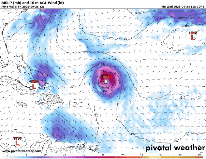
jlauderdal wrote:Magical power we have in SE Florida

Sent from my Pixel 9 using Tapatalk


Indeed, the power of complacency. I sincerely hope there's no surprises this year because this joke attitude is often taken the wrong way, as we've seen with past posters on here using diagrams and climate change to tell us why SE Florida will never be hit again. Obviously a lot of us don't think this is funny.


Having lived here, I can tell you why those beliefs persist. In my 66 years, not only has South Florida exploded in co struction, but we actually see how it changed our weather patterns first hand. Its used to rain every afternoon in the summer, all the way to the coast, now, it still does that, but 20 miles inland. Then its hurricane history that shows them avoiding populated areas. Hurricane Andrew was predicted to hit Hollywood/Ft Laud, but made a beeline south of where the concrete wall starts.. And we've more than doubled since Andrew. Though I'd never say never, I have my doubts..


Perhaps I am misunderstanding this post but are you saying that the construction itself changed the weather patterns? Can you please elaborate?
1 likes   

LarryWx
S2K Supporter
S2K Supporter
Posts: 6830
Joined: Sun Sep 07, 2003 2:04 pm
Location: GA

Re: NATL: INVEST 94L - Models

#46 Postby LarryWx » Wed Sep 24, 2025 2:54 pm

The 12Z EPS, like 0Z and 12Z of yesterday, actually has an uncomfortably high # of members (10+/20%+) hitting the SE US 9/28-10/4, which is earlier than the 10/5-7 12Z Euro freakish US hit.

One thing that’s a bit concerning is the forecasted MJO phase 2 by both GEFS and EPS for 9/27-10/3. As I posted about last month, phase 2 has had (whether inside or outside the circle) by a wide margin the highest % (after taking into account % of days in each phase) of Conus Jul-Sept MH hits and along with phase 8 the highest % of H hits since 1975.
5 likes   
Personal Forecast Disclaimer:
The posts in this forum are NOT official forecasts and should not be used as such. They are just the opinion of the poster and may or may not be backed by sound meteorological data. They are NOT endorsed by any professional institution or storm2k.org. For official information, please refer to the NHC and NWS products.

BobHarlem
Category 5
Category 5
Posts: 2535
Joined: Thu Oct 20, 2005 6:11 pm

Re: NATL: INVEST 94L - Models

#47 Postby BobHarlem » Wed Sep 24, 2025 2:58 pm

12z euro ensembles
Image
1 likes   

TomballEd
Category 5
Category 5
Posts: 1062
Age: 61
Joined: Wed Aug 16, 2023 4:52 pm
Location: Spring/Klein area, not Tomball

Re: NATL: INVEST 94L - Models

#48 Postby TomballEd » Wed Sep 24, 2025 3:05 pm


Quite the ridge building over the top as well.
0 likes   

User avatar
StormWeather
Category 1
Category 1
Posts: 445
Joined: Wed Jun 05, 2024 2:34 pm

Re: NATL: INVEST 94L - Models

#49 Postby StormWeather » Wed Sep 24, 2025 3:06 pm

LarryWx wrote:The 12Z EPS, like 0Z and 12Z of yesterday, actually has an uncomfortably high # of members (10+/20%+) hitting the SE US 9/28-10/4, which is earlier than the 10/5-7 12Z Euro freakish US hit.

One thing that’s a bit concerning is the forecasted MJO phase 2 by both GEFS and EPS for 9/27-10/3. As I posted about last month, phase 2 has had (whether inside or outside the circle) by a wide margin the highest % (after taking into account % of days in each phase) of Conus Jul-Sept MH hits and along with phase 8 the highest % of H hits since 1975.

The U.S east coast also hasn’t truly be tested (with new building codes and improvements having come about in the last 20 years) since Hurricane Jeanne in 2004 (the last MH to landfall on the east coast). IF this does end up becoming a MH in the future (if it forms at all) then this may be the test.
3 likes   
Just an average cyclone tracker

The posts in this forum are NOT official forecasts and should not be used as such. They are just the opinion of the poster and may or may not be backed by sound meteorological data. They are NOT endorsed by any professional institution or storm2k.org. For official information, please refer to the NHC and NWS products

TomballEd
Category 5
Category 5
Posts: 1062
Age: 61
Joined: Wed Aug 16, 2023 4:52 pm
Location: Spring/Klein area, not Tomball

Re: NATL: INVEST 94L - Models

#50 Postby TomballEd » Wed Sep 24, 2025 3:28 pm

StormWeather wrote:
LarryWx wrote:The 12Z EPS, like 0Z and 12Z of yesterday, actually has an uncomfortably high # of members (10+/20%+) hitting the SE US 9/28-10/4, which is earlier than the 10/5-7 12Z Euro freakish US hit.

One thing that’s a bit concerning is the forecasted MJO phase 2 by both GEFS and EPS for 9/27-10/3. As I posted about last month, phase 2 has had (whether inside or outside the circle) by a wide margin the highest % (after taking into account % of days in each phase) of Conus Jul-Sept MH hits and along with phase 8 the highest % of H hits since 1975.

The U.S east coast also hasn’t truly be tested (with new building codes and improvements having come about in the last 20 years) since Hurricane Jeanne in 2004 (the last MH to landfall on the east coast). IF this does end up becoming a MH in the future (if it forms at all) then this may be the test.


I doubt it is directly related to climate change, but I remember when EC Florida and the Carolinas were the magnets and Opal type Gulf storms were memorable for being rare. If it swings back to ECUSA for major TC impacts, well, could be a cycle.
2 likes   

KPILM
Tropical Low
Tropical Low
Posts: 11
Joined: Wed Aug 07, 2024 6:57 am

Re: NATL: INVEST 94L - Models

#51 Postby KPILM » Wed Sep 24, 2025 3:29 pm

StormWeather wrote:
LarryWx wrote:The 12Z EPS, like 0Z and 12Z of yesterday, actually has an uncomfortably high # of members (10+/20%+) hitting the SE US 9/28-10/4, which is earlier than the 10/5-7 12Z Euro freakish US hit.

One thing that’s a bit concerning is the forecasted MJO phase 2 by both GEFS and EPS for 9/27-10/3. As I posted about last month, phase 2 has had (whether inside or outside the circle) by a wide margin the highest % (after taking into account % of days in each phase) of Conus Jul-Sept MH hits and along with phase 8 the highest % of H hits since 1975.

The U.S east coast also hasn’t truly be tested (with new building codes and improvements having come about in the last 20 years) since Hurricane Jeanne in 2004 (the last MH to landfall on the east coast). IF this does end up becoming a MH in the future (if it forms at all) then this may be the test.


I still drive past abandoned remnants of homes chewed up by Florence almost every day, I think that was a pretty good test.
3 likes   

CrazyC83
Professional-Met
Professional-Met
Posts: 34148
Joined: Tue Mar 07, 2006 11:57 pm
Location: Deep South, for the first time!

Re: NATL: INVEST 94L - Models

#52 Postby CrazyC83 » Wed Sep 24, 2025 3:40 pm

I think Humberto holds the key here. If Humberto is stronger, then I suspect this storm gets forced to the coast as it rotates north-northwestward. A weaker Humberto avoids the Fujiwhara and allows this system to follow it out to sea (although Bermuda may be in play).
1 likes   

LarryWx
S2K Supporter
S2K Supporter
Posts: 6830
Joined: Sun Sep 07, 2003 2:04 pm
Location: GA

Re: NATL: INVEST 94L - Models

#53 Postby LarryWx » Wed Sep 24, 2025 3:58 pm

StormWeather wrote:
LarryWx wrote:The 12Z EPS, like 0Z and 12Z of yesterday, actually has an uncomfortably high # of members (10+/20%+) hitting the SE US 9/28-10/4, which is earlier than the 10/5-7 12Z Euro freakish US hit.

One thing that’s a bit concerning is the forecasted MJO phase 2 by both GEFS and EPS for 9/27-10/3. As I posted about last month, phase 2 has had (whether inside or outside the circle) by a wide margin the highest % (after taking into account % of days in each phase) of Conus Jul-Sept MH hits and along with phase 8 the highest % of H hits since 1975.

The U.S east coast also hasn’t truly be tested (with new building codes and improvements having come about in the last 20 years) since Hurricane Jeanne in 2004 (the last MH to landfall on the east coast). IF this does end up becoming a MH in the future (if it forms at all) then this may be the test.


These 9 MH hit the Conus during phase 2

Ida (2021)
Irma (2017)
Harvey (2017)
Ivan (2004)
Brett (1999)
Emily (1993)
Hugo (1989)
Frederic (1979)
Eloise (1975)

That’s 9 of 23 MH (39%) Jul-Sep hitting Conus just during phase 2. Out of 4,508 days during Jul-Sep 1975-2024 (1978 excluded because MJO unknown), there were 756 days during phase 2 or 17% of the days. The 17% is well under the 39%.

In addition to those 9 MH, these highly impactful H also hit during phase 2:

Hanna (2020)
Florence (2018)
Gustav (2008)
Katrina FL portion (2005)
Frances (2004)
Erin (1995)
1 likes   
Personal Forecast Disclaimer:
The posts in this forum are NOT official forecasts and should not be used as such. They are just the opinion of the poster and may or may not be backed by sound meteorological data. They are NOT endorsed by any professional institution or storm2k.org. For official information, please refer to the NHC and NWS products.

User avatar
AJC3
Admin
Admin
Posts: 4126
Age: 61
Joined: Tue Aug 31, 2004 7:04 pm
Location: Ballston Spa, New York
Contact:

Re: NATL: INVEST 94L - Models

#54 Postby AJC3 » Wed Sep 24, 2025 4:04 pm

CrazyC83 wrote:I think Humberto holds the key here. If Humberto is stronger, then I suspect this storm gets forced to the coast as it rotates north-northwestward. A weaker Humberto avoids the Fujiwhara and allows this system to follow it out to sea (although Bermuda may be in play).


While I agree that Humberto holds the key, I'd suspect the opposite is true for 2 reasons:

1. A stronger Humberto is likely to have a larger RMW, both of which would be MORE likely to cause a stronger binary interaction.

2. A stronger/larger Humberto will also cause greater erosion of the western flank of the Atlantic ridge to the north of 94L.

What would be useful in this regard is an ensemble correlation for both systems. Bifurcate the stronger ensemble members for Humberto from the weaker ones, then look at how this impacts the track/intensity of 94L.
2 likes   

floridasun
Tropical Storm
Tropical Storm
Posts: 244
Joined: Tue Sep 14, 2021 3:59 pm

Re: NATL: INVEST 94L - Models

#55 Postby floridasun » Wed Sep 24, 2025 4:09 pm

so, models going crazy because two system close each other
0 likes   

Stratton23
Category 5
Category 5
Posts: 2827
Joined: Fri Jul 21, 2023 10:59 pm
Location: Katy, Tx

Re: NATL: INVEST 94L - Models

#56 Postby Stratton23 » Wed Sep 24, 2025 4:27 pm

18z ICON had a much stronger ridge, upper low over the SE US is significantly weaker
0 likes   

BobHarlem
Category 5
Category 5
Posts: 2535
Joined: Thu Oct 20, 2005 6:11 pm

Re: NATL: INVEST 94L - Models

#57 Postby BobHarlem » Wed Sep 24, 2025 4:28 pm

18z icon, bit of a left shift for both systems.

Image
1 likes   

User avatar
AnnularCane
S2K Supporter
S2K Supporter
Posts: 2940
Joined: Thu Jun 08, 2006 9:18 am
Location: Wytheville, VA

Re: NATL: INVEST 94L - Models

#58 Postby AnnularCane » Wed Sep 24, 2025 4:30 pm

BobHarlem wrote:18z icon, bit of a left shift for both systems.

https://i.postimg.cc/hPTC6nXz/floop-icon-2025092418-sfcwind-mslp-watl.gif


Looks like Humberto is chasing her. :lol:
3 likes   
"But it never rained rain. It never snowed snow. And it never blew just wind. It rained things like soup and juice. It snowed mashed potatoes and green peas. And sometimes the wind blew in storms of hamburgers." -- Judi Barrett, Cloudy with a Chance of Meatballs

LarryWx
S2K Supporter
S2K Supporter
Posts: 6830
Joined: Sun Sep 07, 2003 2:04 pm
Location: GA

Re: NATL: INVEST 94L - Models

#59 Postby LarryWx » Wed Sep 24, 2025 4:30 pm

AJC3 wrote:
CrazyC83 wrote:I think Humberto holds the key here. If Humberto is stronger, then I suspect this storm gets forced to the coast as it rotates north-northwestward. A weaker Humberto avoids the Fujiwhara and allows this system to follow it out to sea (although Bermuda may be in play).


While I agree that Humberto holds the key, I'd suspect the opposite is true for 2 reasons:

1. A stronger Humberto is likely to have a larger RMW, both of which would be MORE likely to cause a stronger binary interaction.

2. A stronger/larger Humberto will also cause greater erosion of the western flank of the Atlantic ridge to the north of 94L.

What would be useful in this regard is an ensemble correlation for both systems. Bifurcate the stronger ensemble members for Humberto from the weaker ones, then look at how this impacts the track/intensity of 94L.


Upon closer inspection, 40% (20) of 12Z EPS members affect a portion of the SE with either a TC direct landfall, a skirting of the coast, or a weak remnant. Also, a clear majority of members that weren’t steered by a Fujiwhara from Humberto were in that 40%. So, whether or not Humberto pulls 94L into it might turn out to be the crucial factor for whether or not the SE US is threatened.
1 likes   
Personal Forecast Disclaimer:
The posts in this forum are NOT official forecasts and should not be used as such. They are just the opinion of the poster and may or may not be backed by sound meteorological data. They are NOT endorsed by any professional institution or storm2k.org. For official information, please refer to the NHC and NWS products.

User avatar
Blown Away
S2K Supporter
S2K Supporter
Posts: 10225
Joined: Wed May 26, 2004 6:17 am

Re: NATL: INVEST 94L - Models

#60 Postby Blown Away » Wed Sep 24, 2025 4:48 pm

Image
18z ICON
2 likes   
Hurricane Eye Experience: David 79, Irene 99, Frances 04, Jeanne 04, Wilma 05… Hurricane Brush Experience: Andrew 92, Erin 95, Floyd 99, Matthew 16, Irma 17, Ian 22, Nicole 22…


Return to “2025”

Who is online

Users browsing this forum: No registered users and 43 guests