EP, 14, 2025092318, , BEST, 0, 154N, 1078W, 75, 981, HU
EPAC: NARDA - Remnants - Discussion
Moderator: S2k Moderators
-
cycloneye

- Admin

- Posts: 149276
- Age: 69
- Joined: Thu Oct 10, 2002 10:54 am
- Location: San Juan, Puerto Rico
Re: EPAC: NARDA - Hurricane - Discussion
No change.
0 likes
Visit the Caribbean-Central America Weather Thread where you can find at first post web cams,radars
and observations from Caribbean basin members Click Here
and observations from Caribbean basin members Click Here
-
cycloneye
- Admin
- Posts: 149276
- Age: 69
- Joined: Thu Oct 10, 2002 10:54 am
- Location: San Juan, Puerto Rico
Re: EPAC: NARDA - Hurricane - Discussion
BULLETIN
Hurricane Narda Advisory Number 9
NWS National Hurricane Center Miami FL EP142025
200 PM MST Tue Sep 23 2025
...NARDA CONTINUES TO MOVE AWAY FROM MEXICO...
SUMMARY OF 200 PM MST...2100 UTC...INFORMATION
----------------------------------------------
LOCATION...15.4N 108.4W
ABOUT 365 MI...590 KM SW OF MANZANILLO MEXICO
MAXIMUM SUSTAINED WINDS...85 MPH...140 KM/H
PRESENT MOVEMENT...W OR 260 DEGREES AT 13 MPH...20 KM/H
MINIMUM CENTRAL PRESSURE...981 MB...28.97 INCHES
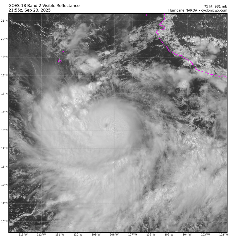
Hurricane Narda Discussion Number 9
NWS National Hurricane Center Miami FL EP142025
200 PM MST Tue Sep 23 2025
After steadily strengthening over the past day or so, Narda's
intensity appears to have leveled off for now. Overall, the cloud
pattern of the hurricane has not changed much during the past
several hours and it continues to maintain a central dense overcast
feature with outer rainbands surrounding it. The latest satellite
intensity estimates have generally held steady today and support
maintaining the initial wind speed at 75 kt. An ASCAT-C pass from a
few hours ago confirmed that Narda is a small hurricane with its
tropical-storm-force winds estimated to only extend up to 80 n mi
from the center.
The hurricane has been losing latitude today, and the initial motion
is now estimated to be 260/11 kt. This south of due west motion is
caused by a strong subtropical ridge situated to Narda's
north-northwest, and it should keep Narda on a general westward path
for the next few days. After that time, the models show a weakness
developing in the ridge associated with a cut off low moving
southward over southern California, which should cause Narda to slow
down and turn northwestward over the weekend. The NHC track
forecast is a little south of the previous one, based mostly on
the more southward initial position and motion.
Narda is likely to continue to strengthen through tonight.
However, the latest models show a notable increase in easterly
shear over the hurricane on Wednesday and Thursday, and that could
cause the intensity to level off. The shear is expected to lessen
late Thursday and Friday, allowing an opportunity for Narda
to strengthen again before it moves over cool waters and into a
stable air mass this weekend. The NHC intensity forecast is a
little lower than the previous one in the short term, but still lies
near the high end of the guidance. Little change was made to the
previous long-term intensity forecast.
FORECAST POSITIONS AND MAX WINDS
INIT 23/2100Z 15.4N 108.4W 75 KT 85 MPH
12H 24/0600Z 15.2N 110.0W 85 KT 100 MPH
24H 24/1800Z 15.1N 112.2W 85 KT 100 MPH
36H 25/0600Z 15.2N 114.5W 85 KT 100 MPH
48H 25/1800Z 15.5N 116.9W 85 KT 100 MPH
60H 26/0600Z 16.1N 119.2W 90 KT 105 MPH
72H 26/1800Z 16.8N 121.2W 95 KT 110 MPH
96H 27/1800Z 18.5N 123.2W 90 KT 105 MPH
120H 28/1800Z 20.4N 123.3W 65 KT 75 MPH
$$
Forecaster Cangialosi
0 likes
Visit the Caribbean-Central America Weather Thread where you can find at first post web cams,radars
and observations from Caribbean basin members Click Here
and observations from Caribbean basin members Click Here


Re: EPAC: NARDA - Hurricane - Discussion
Nascent eye is visible. Should be a major hurricane soon. Think by late week once it goes poleward will see another peak.

7 likes
The above post and any post by Ntxw is NOT an official forecast and should not be used as such. It is just the opinion of the poster and may or may not be backed by sound meteorological data. It is NOT endorsed by any professional institution including Storm2k. For official information, please refer to NWS products.
Help support Storm2K!

-
Kingarabian

- S2K Supporter

- Posts: 16348
- Joined: Sat Aug 08, 2009 3:06 am
- Location: Honolulu, Hawaii
Re: EPAC: NARDA - Hurricane - Discussion
Confused why theyre not calling for a major hurricane
2 likes
RIP Kobe Bryant
-
Kingarabian
- S2K Supporter
- Posts: 16348
- Joined: Sat Aug 08, 2009 3:06 am
- Location: Honolulu, Hawaii
Re: EPAC: NARDA - Hurricane - Discussion
Classic EPAC pinhole major on the way?
6 likes
RIP Kobe Bryant
-
cycloneye
- Admin
- Posts: 149276
- Age: 69
- Joined: Thu Oct 10, 2002 10:54 am
- Location: San Juan, Puerto Rico
Re: EPAC: NARDA - Hurricane - Discussion
Cat 2.
EP, 14, 2025092400, , BEST, 0, 153N, 1088W, 85, 972, HU
0 likes
Visit the Caribbean-Central America Weather Thread where you can find at first post web cams,radars
and observations from Caribbean basin members Click Here
and observations from Caribbean basin members Click Here


Re: EPAC: NARDA - Hurricane - Discussion
Certainly coming along nicely. After an apparently unsuccessful attempt to clear out an eye earlier this evening, Narda is now giving it another shot. Objective Dvorak numbers are low - hovering around T4.5 - but the latest subjective fix was a 5.0 with the bulletin noting a rapidly developing trend. IMO it is entirely possible that this one will outperform the forecast, at least in the near term.
2 likes

Re: EPAC: NARDA - Hurricane - Discussion
It looks like Narda is still a bit sheared?
2 likes
TC naming lists: retirements and intensity
Most aggressive Advisory #1's in North Atlantic (cr. kevin for starting the list)
Most aggressive Advisory #1's in North Atlantic (cr. kevin for starting the list)
-
cycloneye
- Admin
- Posts: 149276
- Age: 69
- Joined: Thu Oct 10, 2002 10:54 am
- Location: San Juan, Puerto Rico
Re: EPAC: NARDA - Hurricane - Discussion
Yes. Is now forecast to reach cat 3 on day 3.
BULLETIN
Hurricane Narda Advisory Number 10
NWS National Hurricane Center Miami FL EP142025
800 PM MST Tue Sep 23 2025
...NARDA STRENGTHENS INTO A CATEGORY 2 HURRICANE WELL TO THE SOUTH
OF BAJA CALIFORNIA...
SUMMARY OF 800 PM MST...0300 UTC...INFORMATION
----------------------------------------------
LOCATION...15.3N 109.4W
ABOUT 525 MI...845 KM S OF THE SOUTHERN TIP OF BAJA CALIFORNIA
MAXIMUM SUSTAINED WINDS...100 MPH...155 KM/H
PRESENT MOVEMENT...W OR 265 DEGREES AT 13 MPH...20 KM/H
MINIMUM CENTRAL PRESSURE...972 MB...28.71 INCHES
Hurricane Narda Discussion Number 10
NWS National Hurricane Center Miami FL EP142025
800 PM MST Tue Sep 23 2025
Narda appears to have strengthened since the previous advisory, with
an eye, albeit cloud-filled and cold, periodically evident in
visible and infrared satellite imagery. The cyclone continues to
experience easterly vertical wind shear, with outflow restricted in
the eastern semicircle. This is evident in satellite imagery and
confirmed by the latest UW-CIMSS shear analysis, which indicates 19
kt of easterly shear. Subjective Dvorak estimates from TAFB and SAB
were 4.5/77 kt and 5.0/90 kt, respectively, while objective
estimates from UW-CIMSS ranged from 80 to 93 kt. Taking a blend of
these data, and accounting for the improved satellite presentation,
supports raising the initial intensity to 85 kt for this advisory.
Narda is estimated to be moving just south of due west, or 265
degrees, at 11 kt. A general westward motion is expected to
continue during the next couple of days as the cyclone is steered by
a strengthening subtropical ridge to its north and northwest. A
turn toward the northwest is expected around day 3 as a mid-level
low over southern California erodes the eastern portion of the
subtropical ridge. A more northward motion with a decrease in
forward speed is forecast by days 4 and 5 as the cyclone moves into
the weakness in the subtropical ridge created by the mid-level low
to its north. The official forecast track is very similar to the
previous advisory and remains close to the middle of the track
guidance envelope.
Narda will remain embedded within a moist air mass and over very
warm waters during the next couple of days. Shear will hold at
moderate levels tonight, which may allow for some slight
strengthening, and this is reflected in the intensity forecast. The
easterly shear is then forecast to increase to near 30 kt on
Wednesday, and this is expected to disrupt the cyclone enough to
cause some weakening. Narda should move out of the moderate to
strong easterly shear while remaining over warm waters and
surrounded by moist mid-level air on Thursday. This environment
should allow for a period of re-intensification, with Narda forecast
to peak at major hurricane strength around day 3. Sea surface
temperatures will gradually decrease late in the forecast period,
with Narda crossing the 26C isotherm around day 4. The cyclone will
also be moving into a much drier mid-level airmass and a more stable
environment, which should result in steady weakening by day 4 and
rapid weakening by day 5. The official intensity forecast is most
closely aligned with the HCCA intensity aid.
FORECAST POSITIONS AND MAX WINDS
INIT 24/0300Z 15.3N 109.4W 85 KT 100 MPH
12H 24/1200Z 15.2N 111.0W 90 KT 105 MPH
24H 25/0000Z 15.2N 113.3W 80 KT 90 MPH
36H 25/1200Z 15.4N 115.6W 80 KT 90 MPH
48H 26/0000Z 15.8N 118.1W 85 KT 100 MPH
60H 26/1200Z 16.3N 120.3W 90 KT 105 MPH
72H 27/0000Z 17.1N 121.9W 100 KT 115 MPH
96H 28/0000Z 19.0N 123.4W 85 KT 100 MPH
120H 29/0000Z 21.5N 123.0W 55 KT 65 MPH
$$
Forecaster Jelsema (CPHC)
1 likes
Visit the Caribbean-Central America Weather Thread where you can find at first post web cams,radars
and observations from Caribbean basin members Click Here
and observations from Caribbean basin members Click Here
-
cycloneye
- Admin
- Posts: 149276
- Age: 69
- Joined: Thu Oct 10, 2002 10:54 am
- Location: San Juan, Puerto Rico
Re: EPAC: NARDA - Hurricane - Discussion
BULLETIN
Hurricane Narda Advisory Number 11
NWS National Hurricane Center Miami FL EP142025
200 AM MST Wed Sep 24 2025
...NARDA STRENGTHENS SOME MORE WHILE REMAINING WELL TO THE SOUTH OF
BAJA CALIFORNIA...
SUMMARY OF 200 AM MST...0900 UTC...INFORMATION
----------------------------------------------
LOCATION...15.1N 110.5W
ABOUT 540 MI...870 KM S OF THE SOUTHERN TIP OF BAJA CALIFORNIA
MAXIMUM SUSTAINED WINDS...105 MPH...165 KM/H
PRESENT MOVEMENT...W OR 265 DEGREES AT 13 MPH...20 KM/H
MINIMUM CENTRAL PRESSURE...970 MB...28.65 INCHES
Hurricane Narda Discussion Number 11
NWS National Hurricane Center Miami FL EP142025
200 AM MST Wed Sep 24 2025
The low-level center of Narda has been mostly obscured by a central
dense overcast with cloud-top temperatures of -70 to -85C, following
a brief eye feature that developed near the time of the previous
advisory package. Since then, the cyclone has begun to feel the
effects of increasing vertical wind shear. UW-CIMSS now analyzes 22
kt of east-northeasterly shear, and satellite imagery shows
increasing outflow restriction in the eastern semicircle.
Subjective Dvorak estimates from TAFB and SAB were both 5.0/90 kt,
while objective estimates from UW-CIMSS ranged from 84 to 101 kt.
Taking a blend of these data, the initial intensity for this
advisory has been raised to 90 kt.
Narda is estimated to be moving just south of due west, or 265
degrees, at 11 kt. A general westward motion is expected to
continue during the next couple of days as the cyclone is steered by
a strengthening subtropical ridge to its north and northwest. A
turn toward the northwest is expected by day 3 as a mid-level low
over southern California erodes the eastern portion of the
subtropical ridge. A more northward motion with a decrease in
forward speed is forecast by days 4 and 5 as the cyclone moves into
the weakness in the ridge created by the mid-level low. The
official forecast track is very similar to the previous advisory for
the next couple of days, then was shifted slightly to the left
beyond 48 hours to better align with trends in the consensus
guidance.
Narda will remain embedded within a moist air mass and over very
warm waters during the next couple of days. Despite these favorable
conditions for intensification, east-northeasterly shear is forecast
to increase to near 30 kt later today and tonight, which is expected
to disrupt the cyclone enough to cause some weakening. Narda should
emerge from the hostile shear environment on Thursday while still
over warm waters and surrounded by moist mid-level air. This should
allow for a period of re-intensification, with Narda forecast to
peak at major hurricane strength around day 3. Sea surface
temperatures will decrease rather abruptly beyond day 3, with Narda
crossing the 26C isotherm prior to day 4 while also moving into a
progressively drier and more stable environment. As a result, rapid
weakening is forecast by days 4 and 5, with Narda expected to lose
deep convection and become a post-tropical low by day 5. The
official intensity forecast is similar to the previous prediction
and most closely aligned with a blend of the HCCA and FSSE intensity
aids.
FORECAST POSITIONS AND MAX WINDS
INIT 24/0900Z 15.1N 110.5W 90 KT 105 MPH
12H 24/1800Z 15.1N 112.2W 85 KT 100 MPH
24H 25/0600Z 15.2N 114.5W 80 KT 90 MPH
36H 25/1800Z 15.5N 116.9W 80 KT 90 MPH
48H 26/0600Z 15.9N 119.5W 85 KT 100 MPH
60H 26/1800Z 16.6N 121.7W 95 KT 110 MPH
72H 27/0600Z 17.6N 123.3W 100 KT 115 MPH
96H 28/0600Z 19.4N 124.3W 75 KT 85 MPH
120H 29/0600Z 21.8N 123.8W 45 KT 50 MPH...POST-TROPICAL
$$
Forecaster Jelsema (CPHC)
0 likes
Visit the Caribbean-Central America Weather Thread where you can find at first post web cams,radars
and observations from Caribbean basin members Click Here
and observations from Caribbean basin members Click Here
-
Kingarabian
- S2K Supporter
- Posts: 16348
- Joined: Sat Aug 08, 2009 3:06 am
- Location: Honolulu, Hawaii
Re: EPAC: NARDA - Hurricane - Discussion
Looks like it peaked yesterday as a cat.3 since it was able to attain 5.5 at one point. Has a second peak coming up in about 24-36 hours.
0 likes
RIP Kobe Bryant
-
cycloneye
- Admin
- Posts: 149276
- Age: 69
- Joined: Thu Oct 10, 2002 10:54 am
- Location: San Juan, Puerto Rico
Re: EPAC: NARDA - Hurricane - Discussion
BULLETIN
Hurricane Narda Advisory Number 12
NWS National Hurricane Center Miami FL EP142025
800 AM MST Wed Sep 24 2025
...NARDA HOLDING STEADY FOR NOW...
SUMMARY OF 800 AM MST...1500 UTC...INFORMATION
----------------------------------------------
LOCATION...15.1N 111.7W
ABOUT 550 MI...885 KM SSW OF THE SOUTHERN TIP OF BAJA CALIFORNIA
MAXIMUM SUSTAINED WINDS...105 MPH...165 KM/H
PRESENT MOVEMENT...W OR 265 DEGREES AT 13 MPH...20 KM/H
MINIMUM CENTRAL PRESSURE...972 MB...28.71 INCHES
Hurricane Narda Discussion Number 12
NWS National Hurricane Center Miami FL EP142025
800 AM MST Wed Sep 24 2025
The recent convective structure of Narda is characterized by a CDO
containing cold cloud tops colder than -80C, with a curved band also
noted to the west of the CDO. SHIPS guidance and UW-CIMSS are
currently analyzing 20-25 kt of east-northeasterly shear. This
shear has prevented any strengthening over the past 6 hours. In
fact, the structure appears somewhat less impressive on a recent
24/1121 UTC F18 SSMIS microwave overpass. Given that the latest
TAFB and SAB fixes are both T5.0/90 kt, the 90-kt intensity from the
previous NHC advisory will be held for this advisory.
Narda's motion hasn't changed, still estimated to be westward, or
265 degrees at 11 kt. A general westward motion will continue over
the next 36 h, followed by a gradual turn to the west-northwest as
the cyclone is steered by a mid-level ridge to its north. A
mid-level low over central California is likely to sink southward
toward northern Baja California by Friday night, which will act to
erode the ridge. This should cause Narda to turn rather sharply
toward the north by Saturday, along with a decrease in forward
speed. The official forecast is similar to the previous advisory
for the first couple of days, but lies a bit to the left, or west,
of the previous NHC advisory at days 3-5. The official forecast is
closest to the TVCE and GFEX during that period, which lie in
between the eastern HCCA solution and the western Google Deep Mind
solution.
The aforementioned strong northeasterly vertical wind shear is
expected to continue through tonight, then decrease to moderate
magnitudes by Thursday while Narda remains over warm sea-surface
temperatures and within a moist environment. The NHC forecast will
continue to call for some weakening through tonight, followed by
some restrengthening by Thursday night and into Friday. Narda is
forecast to move into cooler waters and cross the 26C sea-surface
temperature isotherm by Saturday while reaching a somewhat drier
environment around the same time. The NHC forecast shows rapid
weakening during that time.
It should be noted that there is a healthy amount of model spread
beyond Day 3 as to how quickly Narda gains latitude during the
3-5 day period. These track differences could also affect the
intensity forecast (how quickly Narda weakens during that time
period).
FORECAST POSITIONS AND MAX WINDS
INIT 24/1500Z 15.1N 111.7W 90 KT 105 MPH
12H 25/0000Z 15.1N 113.4W 85 KT 100 MPH
24H 25/1200Z 15.4N 115.8W 80 KT 90 MPH
36H 26/0000Z 15.8N 118.3W 80 KT 90 MPH
48H 26/1200Z 16.2N 120.8W 85 KT 100 MPH
60H 27/0000Z 17.0N 122.9W 90 KT 105 MPH
72H 27/1200Z 17.7N 124.2W 95 KT 110 MPH
96H 28/1200Z 19.7N 124.6W 65 KT 75 MPH
120H 29/1200Z 21.8N 123.8W 45 KT 50 MPH...POST-TROPICAL
$$
Forecaster Hagen
0 likes
Visit the Caribbean-Central America Weather Thread where you can find at first post web cams,radars
and observations from Caribbean basin members Click Here
and observations from Caribbean basin members Click Here
-
Sciencerocks
- Category 5

- Posts: 10181
- Age: 40
- Joined: Thu Jul 06, 2017 1:51 am

-
cycloneye
- Admin
- Posts: 149276
- Age: 69
- Joined: Thu Oct 10, 2002 10:54 am
- Location: San Juan, Puerto Rico
Re: EPAC: NARDA - Hurricane - Discussion
BULLETIN
Hurricane Narda Advisory Number 13
NWS National Hurricane Center Miami FL EP142025
200 PM MST Wed Sep 24 2025
...NARDA A LITTLE WEAKER BUT FORECAST TO RESTRENGTHEN ON FRIDAY...
SUMMARY OF 200 PM MST...2100 UTC...INFORMATION
----------------------------------------------
LOCATION...15.1N 112.3W
ABOUT 560 MI...905 KM SSW OF THE SOUTHERN TIP OF BAJA CALIFORNIA
MAXIMUM SUSTAINED WINDS...100 MPH...155 KM/H
PRESENT MOVEMENT...W OR 265 DEGREES AT 10 MPH...17 KM/H
MINIMUM CENTRAL PRESSURE...976 MB...28.82 INCHES
Hurricane Narda Discussion Number 13
NWS National Hurricane Center Miami FL EP142025
200 PM MST Wed Sep 24 2025
Narda has been feeling the impact of 20-25 kt northeasterly wind
shear today. As a result, the convective structure has degraded
somewhat over the past 6-12 hours. Although recent GPMI and ASCAT
fixes indicate that the center is still well underneath the central
dense overcast, the area of convection with cloud tops colder than
-70C has shrunk significantly and the convection has become slightly
more asymmetric. The latest subjective Dvorak estimates are
a consensus T-5.0/90 kt from TAFB and SAB. However, the objective
intensity estimates from UW-CIMSS have decreased significantly over
the past 6-12 hours, and have been mostly in the 65-80 kt range.
Taking into account both the subjective and objective intensity
estimates, the initial intensity is nudged downward slightly to 85
kt for this advisory.
Recent fixes indicate that Narda is moving slightly slower toward
the west than earlier, with the current motion estimated at 265/9
kt. A general westward motion will continue over the next 24-36 h,
followed by a gradual turn to the west-northwest as the cyclone is
steered by a mid-level ridge to its north. A mid-level low over
central California is expected to sink southward toward northern
Baja California by Friday night, which will erode the ridge and
induce a sharp northward turn by Saturday, along with a decrease in
forward speed. The official forecast is slightly slower than the
previous NHC advisory during the first 2 days, mainly due to the
initial position being slightly farther east. After that time, the
latest forecast is very near the previous official forecast. The
official forecast is closest to the latest TVCE consensus through 60
h, and then lies in between the TVCE and HCCA from days 3-5.
The aforementioned strong northeasterly vertical wind shear is
expected to continue through the next 12-24 h, then decrease to
moderate magnitudes by Thursday afternoon while Narda remains over
warm sea-surface temperatures and within a moist environment. The
NHC forecast will therefore call for continued weakening through
the next 24 h, followed by some restrengthening on Friday. On
Saturday, Narda is forecast to move into cooler waters and cross the
26C sea-surface temperature isotherm while reaching a somewhat drier
environment. The NHC forecast shows rapid weakening over the
weekend as Narda moves over progressively cooler waters. Overall,
the latest NHC intensity forecast is slightly lower than the
previous prediction.
It should be noted that there is a healthy amount of track model
spread beyond Day 3. These track differences will determine
what water temperatures Narda encounters in 3-5 days, which
will affect the intensity forecast (how quickly Narda weakens during
that time period).
FORECAST POSITIONS AND MAX WINDS
INIT 24/2100Z 15.1N 112.3W 85 KT 100 MPH
12H 25/0600Z 15.3N 114.2W 80 KT 90 MPH
24H 25/1800Z 15.6N 116.7W 75 KT 85 MPH
36H 26/0600Z 16.0N 119.3W 75 KT 85 MPH
48H 26/1800Z 16.6N 121.5W 85 KT 100 MPH
60H 27/0600Z 17.3N 123.4W 90 KT 105 MPH
72H 27/1800Z 18.2N 124.4W 85 KT 100 MPH
96H 28/1800Z 20.1N 124.5W 55 KT 65 MPH
120H 29/1800Z 21.9N 123.5W 40 KT 45 MPH...POST-TROPICAL
$$
Forecaster Hagen
0 likes
Visit the Caribbean-Central America Weather Thread where you can find at first post web cams,radars
and observations from Caribbean basin members Click Here
and observations from Caribbean basin members Click Here
-
cycloneye
- Admin
- Posts: 149276
- Age: 69
- Joined: Thu Oct 10, 2002 10:54 am
- Location: San Juan, Puerto Rico
Re: EPAC: NARDA - Hurricane - Discussion
BULLETIN
Hurricane Narda Advisory Number 14
NWS National Hurricane Center Miami FL EP142025
800 PM MST Wed Sep 24 2025
...NARDA WEAKENS SLIGHTLY DUE TO SHEAR BUT FORECAST TO RESTRENGTHEN
ON FRIDAY...
SUMMARY OF 800 PM MST...0300 UTC...INFORMATION
----------------------------------------------
LOCATION...15.1N 113.2W
ABOUT 580 MI...935 KM SSW OF THE SOUTHERN TIP OF BAJA CALIFORNIA
MAXIMUM SUSTAINED WINDS...90 MPH...150 KM/H
PRESENT MOVEMENT...W OR 270 DEGREES AT 10 MPH...17 KM/H
MINIMUM CENTRAL PRESSURE...978 MB...28.88 INCHES
Hurricane Narda Discussion Number 14
NWS National Hurricane Center Miami FL EP142025
800 PM MST Wed Sep 24 2025
Narda has weakened slightly due to persistent 20–25 kt northeasterly
vertical wind shear. However, more recent satellite imagery shows an
expanding burst of very cold convection, with cloud tops to –90 C
redeveloping over the center and a curved band wrapping in from the
southwest. The latest subjective Dvorak classifications from TAFB
and SAB are lower, ranging between T4.0/65 kt and T4.5/77 kt, while
objective intensity estimates from UW-CIMSS are in the 57–68 kt
range. In light of the improved convective presentation during the
past few hours, the initial intensity is only lowered slightly, to
80 kt for this advisory.
The initial motions is toward the west at about 270/9 kt, steered by
a subtropical ridge positioned to its north. The track guidance
remains in good agreement on a general westward motion through about
48 h. Between 48 and 60 h, Narda should turn west-northwestward,
followed by a northwestward motion from 60 to 72 h. Beyond 72 h, a
gradual turn toward the north-northeast is forecast as a weakness
develops in the ridge in response to an upper-level low over
California and a digging shortwave trough over the northeast
Pacific. By days 4 and 5, Narda should continue north-northeastward.
The NHC forecast is close to the previous forecast, aligning closely
with multi-model consensus aids.
Only slight weakening is forecast during the next day or so as the
vertical shear persists. By Friday, the shear is expected to ease to
more moderate levels while Narda remains over warm waters with a
moist environment, which should allow for some re-strengthening. The
northwestward track between 60 and 72 h may also keep the system
over warmer waters a little longer, potentially delaying weakening.
However, by 72–96 h, Narda is forecast to encounter cooler waters
and a drier mid-level airmass, leading to a steady weakening trend.
The cyclone is expected to become post-tropical by day 5 or early
next week. The latest intensity forecast is very similar to the
previous forecast and remains near the middle to upper portion of
the guidance envelope.
FORECAST POSITIONS AND MAX WINDS
INIT 25/0300Z 15.1N 113.2W 80 KT 90 MPH
12H 25/1200Z 15.4N 115.2W 75 KT 85 MPH
24H 26/0000Z 15.7N 117.7W 75 KT 85 MPH
36H 26/1200Z 16.3N 120.2W 75 KT 85 MPH
48H 27/0000Z 16.9N 122.3W 85 KT 100 MPH
60H 27/1200Z 17.7N 124.1W 85 KT 100 MPH
72H 28/0000Z 18.6N 124.9W 75 KT 85 MPH
96H 29/0000Z 20.4N 124.6W 55 KT 65 MPH
120H 30/0000Z 21.8N 124.0W 40 KT 45 MPH...POST-TROPICAL
$$
Forecaster Gibbs (CPHC)
0 likes
Visit the Caribbean-Central America Weather Thread where you can find at first post web cams,radars
and observations from Caribbean basin members Click Here
and observations from Caribbean basin members Click Here
-
Sciencerocks
- Category 5
- Posts: 10181
- Age: 40
- Joined: Thu Jul 06, 2017 1:51 am

-
cycloneye
- Admin
- Posts: 149276
- Age: 69
- Joined: Thu Oct 10, 2002 10:54 am
- Location: San Juan, Puerto Rico
Re: EPAC: NARDA - Hurricane - Discussion
BULLETIN
Hurricane Narda Advisory Number 15
NWS National Hurricane Center Miami FL EP142025
200 AM MST Thu Sep 25 2025
...NARDA HOLDING STEADY WHILE CONTINUING WESTWARD...
SUMMARY OF 200 AM MST...0900 UTC...INFORMATION
----------------------------------------------
LOCATION...15.6N 114.8W
ABOUT 595 MI...960 KM SSW OF THE SOUTHERN TIP OF BAJA CALIFORNIA
MAXIMUM SUSTAINED WINDS...90 MPH...150 KM/H
PRESENT MOVEMENT...W OR 280 DEGREES AT 15 MPH...24 KM/H
MINIMUM CENTRAL PRESSURE...980 MB...28.94 INCHES
Hurricane Narda Discussion Number 15
NWS National Hurricane Center Miami FL EP142025
200 AM MST Thu Sep 25 2025
Narda is holding steady this morning despite persistent 20 kt of
northeasterly vertical wind shear. Recent satellite imagery shows a
well-defined central dense overcast (CDO) with cloud tops near –90
C, along with a curved band wrapping into the center from the
southwest. The latest subjective Dvorak intensity estimates from
TAFB and SAB are both T4.5/77 kt, while objective intensity
estimates from UW-CIMSS range between 61 and 72 kt. Given the
improved satellite presentation over the past few hours and these
estimates, the initial intensity is held at 80 kt.
The initial motion is toward the west near 280/13 kt, and this
forward speed is expected to remain steady through 48 h (Friday
night). After that time, Narda should begin to slow down as it turns
west-northwestward, then northwestward, and eventually northward
through the weekend in response to a weakness developing in the
subtropical ridge. There remains considerable spread in the guidance
regarding the timing of this northward turn. The ECMWF shows a later
turn near 72 h (Saturday night), while the consensus aids indicate
an earlier turn, around 60 h (during the day Saturday). A later turn
would keep Narda over warmer waters longer and allow it to maintain
strength, whereas an earlier turn would move the system over cooler
waters sooner and result in quicker weakening. The official track
forecast is slightly to the left of the previous one after 60 h,
reflecting a blend of the prior forecast and the consensus aids.
Only slight weakening is forecast during the next 12-24 h while the
northeasterly shear persists. Between 24 and 48 h (tonight into
Friday night), the shear is expected to ease to more moderate levels
while Narda remains over warm waters with plenty of mid- to
upper-level moisture, which should allow for a period of
re-strengthening. This forecast lies near the middle to upper
portion of the guidance envelope during that brief window (24–36 h).
By around 60 h (Saturday), sea-surface temperatures along the track
are forecast to fall below 26 C, and steady weakening is forecast
thereafter. Narda is expected to fall below hurricane strength by
the end of the weekend and become a post-tropical remnant low by day
5 (Monday night). The latest intensity forecast is very similar to
the previous one and remains near the middle to upper portion of the
guidance envelope.
FORECAST POSITIONS AND MAX WINDS
INIT 25/0900Z 15.6N 114.8W 80 KT 90 MPH
12H 25/1800Z 15.8N 116.8W 75 KT 85 MPH
24H 26/0600Z 16.3N 119.5W 80 KT 90 MPH
36H 26/1800Z 17.0N 122.0W 85 KT 100 MPH
48H 27/0600Z 17.5N 124.0W 85 KT 100 MPH
60H 27/1800Z 18.2N 125.3W 80 KT 90 MPH
72H 28/0600Z 19.2N 125.8W 65 KT 75 MPH
96H 29/0600Z 21.2N 125.6W 40 KT 45 MPH
120H 30/0600Z 23.0N 124.7W 30 KT 35 MPH...POST-TROP/REMNT LOW
$$
Forecaster Gibbs (CPHC)
0 likes
Visit the Caribbean-Central America Weather Thread where you can find at first post web cams,radars
and observations from Caribbean basin members Click Here
and observations from Caribbean basin members Click Here
-
cycloneye
- Admin
- Posts: 149276
- Age: 69
- Joined: Thu Oct 10, 2002 10:54 am
- Location: San Juan, Puerto Rico
Re: EPAC: NARDA - Hurricane - Discussion
BULLETIN
Hurricane Narda Advisory Number 16
NWS National Hurricane Center Miami FL EP142025
800 AM PDT Thu Sep 25 2025
...NARDA COULD RESTRENGTHEN TO A CATEGORY 2 HURRICANE SOON...
SUMMARY OF 800 AM PDT...1500 UTC...INFORMATION
----------------------------------------------
LOCATION...16.1N 116.6W
ABOUT 640 MI...1030 KM SW OF THE SOUTHERN TIP OF BAJA CALIFORNIA
MAXIMUM SUSTAINED WINDS...90 MPH...150 KM/H
PRESENT MOVEMENT...WNW OR 285 DEGREES AT 15 MPH...24 KM/H
MINIMUM CENTRAL PRESSURE...980 MB...28.94 INCHES
Hurricane Narda Discussion Number 16
NWS National Hurricane Center Miami FL EP142025
800 AM PDT Thu Sep 25 2025
Conventional satellite imagery and a recent AMSR2 microwave
overpass indicate that Narda's cloud pattern has changed little
during the past several hours. The presentation consists of a
well-developed curved band wrapping around the surface center
from the southwest quadrant and a small -81C central dense overcast
(CDO). The subjective intensity estimates from TAFB and SAB are 77
and 90 kt, respectively, and the UW-CIMSS objective technique
estimates have been running just under 80 kt. As a compromise, the
initial intensity is held at 80 kt for this advisory.
Narda should remain over warm oceanic surface temperatures, while
the persistent, modest northeasterly shear diminishes. Therefore,
some strengthening is forecast, and Narda could once again become a
category 2 hurricane by Friday. Afterward, Narda is expected to
traverse progressively cooler SSTs while moving into more
stable/drier thermodynamic environmental conditions. Accordingly,
weakening should occur through the end of the period. The official
intensity forecast is based on a blend of the IVCN and Decay-SHIPS
statistical intensity guidance and has changed little from the
previous forecast.
Narda is estimated to be moving toward the west-northwest, or
285/13 kt, and this general motion should continue through the 36
hour period. Afterward, a cut-off mid-tropospheric low situated
over central California is expected to dip southward toward
northern Baja California by Friday night, forcing Narda to slow in
forward speed and gradually turn northwestward. By early next
week, the cyclone should commence a north-northeastward turn in
response to a major shortwave trough approaching the U.S. west
coast offshore waters. The NHC track forecast has been adjusted
slightly to the left of the previous forecast and lies between the
HCCA Corrected Consensus aid and the GDM FNv3 ensemble model.
FORECAST POSITIONS AND MAX WINDS
INIT 25/1500Z 16.1N 116.6W 80 KT 90 MPH
12H 26/0000Z 16.3N 118.6W 80 KT 90 MPH
24H 26/1200Z 16.8N 121.3W 85 KT 100 MPH
36H 27/0000Z 17.3N 123.7W 85 KT 100 MPH
48H 27/1200Z 18.0N 125.5W 80 KT 90 MPH
60H 28/0000Z 18.9N 126.5W 70 KT 80 MPH
72H 28/1200Z 19.9N 127.0W 55 KT 65 MPH
96H 29/1200Z 22.0N 126.4W 35 KT 40 MPH
120H 30/1200Z 23.3N 125.6W 30 KT 35 MPH...POST-TROP/REMNT LOW
$$
Forecaster Roberts
0 likes
Visit the Caribbean-Central America Weather Thread where you can find at first post web cams,radars
and observations from Caribbean basin members Click Here
and observations from Caribbean basin members Click Here
-
cycloneye
- Admin
- Posts: 149276
- Age: 69
- Joined: Thu Oct 10, 2002 10:54 am
- Location: San Juan, Puerto Rico
Re: EPAC: NARDA - Hurricane - Discussion
BULLETIN
Hurricane Narda Advisory Number 17
NWS National Hurricane Center Miami FL EP142025
200 PM PDT Thu Sep 25 2025
...NARDA HEADING WEST-NORTHWESTWARD...
...SOME RESTRENGTHENING POSSIBLE THROUGH FRIDAY...
SUMMARY OF 200 PM PDT...2100 UTC...INFORMATION
----------------------------------------------
LOCATION...16.2N 118.0W
ABOUT 700 MI...1130 KM SW OF THE SOUTHERN TIP OF BAJA CALIFORNIA
MAXIMUM SUSTAINED WINDS...90 MPH...150 KM/H
PRESENT MOVEMENT...W OR 280 DEGREES AT 16 MPH...26 KM/H
MINIMUM CENTRAL PRESSURE...980 MB...28.94 INCHES
Hurricane Narda Discussion Number 17
NWS National Hurricane Center Miami FL EP142025
200 PM PDT Thu Sep 25 2025
A fortuitous 1329 UTC SAR RCM-1 NRCS image revealed a 15 nm
symmetric eye beneath a small CDO and a deep convective curved
band located over the eastern side of the cyclone. This
afternoon's METOP-B scatterometer pass indicated that the sustained
tropical-storm-force winds have expanded over the eastern
semi-circle of the cyclone. The initial intensity is held at 80 kt
and is based on the various subjective and objective intensity
estimates.
There's still a small window of opportunity for Narda to strengthen
some during the next 12-24 hours while it remains over warm waters,
and favorable upper-wind conditions. Subsequently, Narda
could once again become a category 2 hurricane by Friday.
Over the weekend, Narda is expected to traverse progressively
cooler SSTs while moving into more stable/drier thermodynamic
environmental conditions. Accordingly, weakening should occur
after day 1 and continue through the end of the period. The
official intensity forecast is based on a blend of the IVCN and
Decay-SHIPS statistical intensity guidance and specifies Narda
becoming a post-tropical cyclone in 4 days.
The initial motion is estimated to be generally westward,
or 280/14 kt. By Friday night, a mid-latitude upper-level trough
situated over central California is expected to dip southward toward
northern Baja California, causing Narda to slow down and gradually
turn toward the northwest temporarily. By the 72-hour period, the
cyclone should begin a north-northeast to northeast turn in
response to an major shortwave trough approaching the U.S. west
coast from the northeastern Pacific. The NHC track forecast has
been adjusted slightly to the left of the previous forecast and
lies between the HCCA Corrected Consensus aid and the GDM FNv3
ensemble model.
Narda's wind radii have been adjusted based on a 1631 UTC METOP-B
scatterometer pass.
FORECAST POSITIONS AND MAX WINDS
INIT 25/2100Z 16.2N 118.0W 80 KT 90 MPH
12H 26/0600Z 16.4N 120.0W 85 KT 100 MPH
24H 26/1800Z 16.9N 122.6W 85 KT 100 MPH
36H 27/0600Z 17.4N 124.8W 80 KT 90 MPH
48H 27/1800Z 18.2N 126.4W 70 KT 80 MPH
60H 28/0600Z 19.1N 127.2W 60 KT 70 MPH
72H 28/1800Z 20.3N 127.4W 50 KT 60 MPH
96H 29/1800Z 22.1N 126.4W 35 KT 40 MPH...POST-TROPICAL
120H 30/1800Z 23.6N 125.2W 30 KT 35 MPH...POST-TROP/REMNT LOW
$$
Forecaster Roberts
0 likes
Visit the Caribbean-Central America Weather Thread where you can find at first post web cams,radars
and observations from Caribbean basin members Click Here
and observations from Caribbean basin members Click Here
-
Kingarabian
- S2K Supporter
- Posts: 16348
- Joined: Sat Aug 08, 2009 3:06 am
- Location: Honolulu, Hawaii
Re: EPAC: NARDA - Hurricane - Discussion
Shear appears to be letting up. Convection persisting in the NE quad.
0 likes
RIP Kobe Bryant
Who is online
Users browsing this forum: No registered users and 122 guests