NATL: HUMBERTO - Remnants - Discussion
Moderator: S2k Moderators
-
Hurricane2022

- Category 5

- Posts: 2080
- Joined: Tue Aug 23, 2022 11:38 pm
- Location: Araçatuba, Brazil
Re: NATL: HUMBERTO - Hurricane - Discussion
Where is the recon for this???
1 likes
Sorry for the bad English sometimes...!
For reliable and detailed information for any meteorological phenomenon, please consult the National Hurricane Center, Joint Typhoon Warning Center , or your local Meteo Center.
--------
ECCE OMNIA NOVA FACIAM (Ap 21,5).
For reliable and detailed information for any meteorological phenomenon, please consult the National Hurricane Center, Joint Typhoon Warning Center , or your local Meteo Center.
--------
ECCE OMNIA NOVA FACIAM (Ap 21,5).
-
StormWeather

- Category 1

- Posts: 477
- Joined: Wed Jun 05, 2024 2:34 pm
Re: NATL: HUMBERTO - Hurricane - Discussion
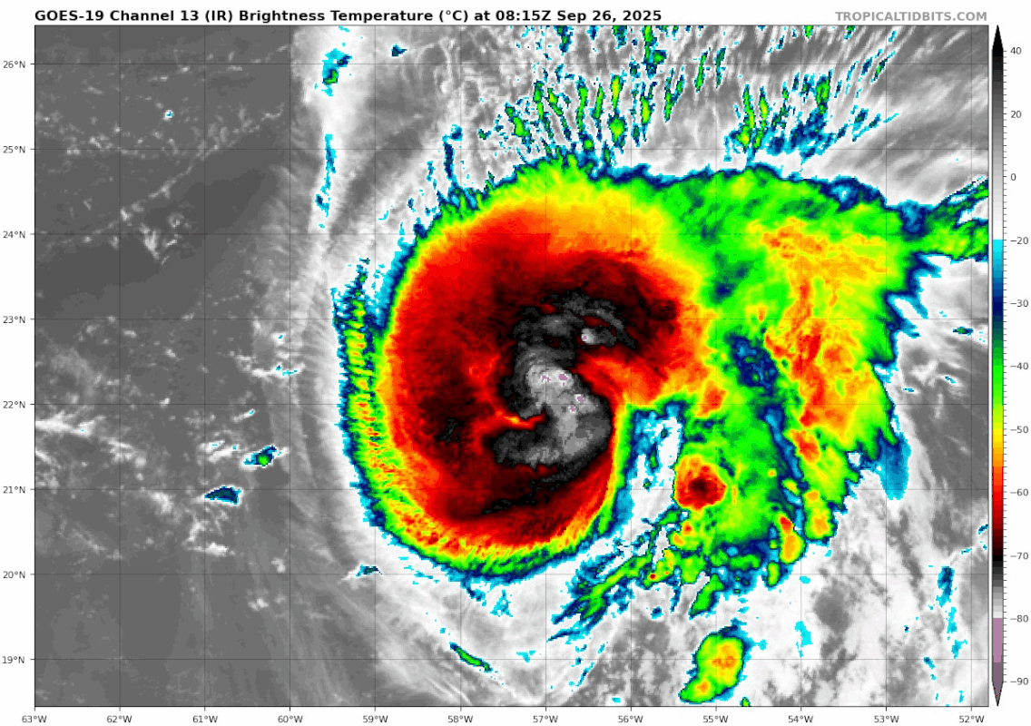
cycloneye wrote:The third hurricane of the season. Below a part of 5 AM discussion.Humberto has become better organized during the past several hours.
Conventional satellite imagery has shown a growing central dense
overcast, with hints of an eye-like feature near the center.
Microwave imagery revealed a well-defined rain band wrapping around
a vertically-aligned vortex, suggesting the developing of an
eyewall.
Two hurricanes within a week. Yep, the Atlantic has woken up for peak season alright.
0 likes
Just an average cyclone tracker
The posts in this forum are NOT official forecasts and should not be used as such. They are just the opinion of the poster and may or may not be backed by sound meteorological data. They are NOT endorsed by any professional institution or storm2k.org. For official information, please refer to the NHC and NWS products
The posts in this forum are NOT official forecasts and should not be used as such. They are just the opinion of the poster and may or may not be backed by sound meteorological data. They are NOT endorsed by any professional institution or storm2k.org. For official information, please refer to the NHC and NWS products


Re: NATL: HUMBERTO - Hurricane - Discussion
StormWeather wrote:cycloneye wrote:The third hurricane of the season. Below a part of 5 AM discussion.Humberto has become better organized during the past several hours.
Conventional satellite imagery has shown a growing central dense
overcast, with hints of an eye-like feature near the center.
Microwave imagery revealed a well-defined rain band wrapping around
a vertically-aligned vortex, suggesting the developing of an
eyewall.
Two hurricanes within a week. Yep, the Atlantic has woken up for peak season alright.
…Late September is the new late August these past few seasons it seems
0 likes

Re: NATL: HUMBERTO - Hurricane - Discussion
So far in 2024 and 2025 combined only 1 TC became a hurricane in the Aug 20 - Sep 20 period. In comparison, 8 TCs became hurricanes in the Sep 20 - Oct 20 period and note that it's only Sep 26 so far and this year is included in these statistics. So the stats will likely become even more extreme as the season continues. Incredibly anomalous hurricane formation so far these two seasons.
Last edited by kevin on Fri Sep 26, 2025 4:12 am, edited 1 time in total.
1 likes
-
weeniepatrol

- Category 5
- Posts: 1345
- Joined: Sat Aug 22, 2020 5:30 pm
- Location: WA State
-
cycloneye

- Admin

- Posts: 149664
- Age: 69
- Joined: Thu Oct 10, 2002 10:54 am
- Location: San Juan, Puerto Rico
Re: NATL: HUMBERTO - Hurricane - Discussion
This is good news as the gulfstrean jet that samples the upper atmosphere went a few hours ago over Humberto and that data will feed the models. Now is flying in the 94L area.

1 likes
Visit the Caribbean-Central America Weather Thread where you can find at first post web cams,radars
and observations from Caribbean basin members Click Here
and observations from Caribbean basin members Click Here
-
cheezyWXguy

- Category 5
- Posts: 6282
- Joined: Mon Feb 13, 2006 12:29 am
- Location: Dallas, TX
Re: NATL: HUMBERTO - Hurricane - Discussion
weeniepatrol wrote:https://imgur.com/4VCXko4
Looks consistent with what I see on visible this morning, a somewhat large inner core for its size. I don’t think we’ll be getting an Erin-esque pinhole out of this one, but a larger core may strengthen its ability to fend off eyewall replacement cycles in the future.
1 likes

Re: NATL: HUMBERTO - Hurricane - Discussion
0 likes
TC naming lists: retirements and intensity
Most aggressive Advisory #1's in North Atlantic (cr. kevin for starting the list)
Most aggressive Advisory #1's in North Atlantic (cr. kevin for starting the list)
Re: NATL: HUMBERTO - Hurricane - Discussion
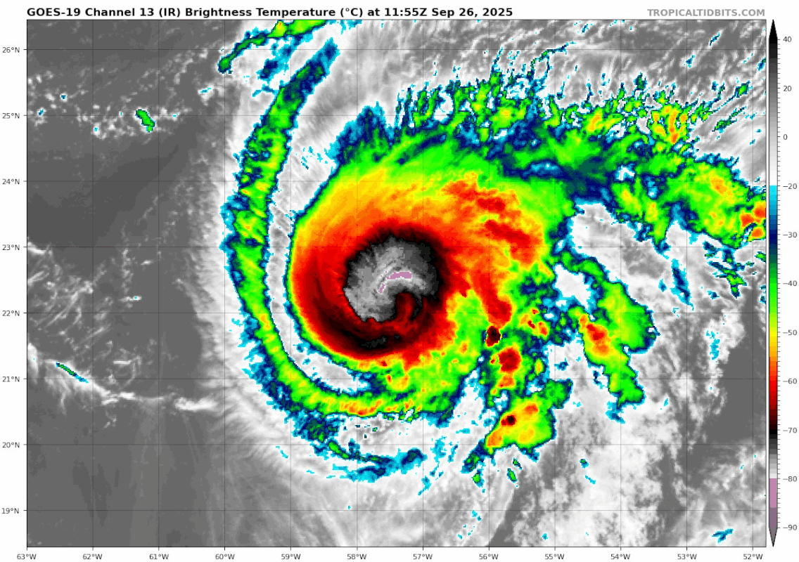
The eye is slowly becoming visible (on VIS). Based on VIS and IR it'll most likely be quite a large eye.

1 likes
-
cheezyWXguy
- Category 5
- Posts: 6282
- Joined: Mon Feb 13, 2006 12:29 am
- Location: Dallas, TX
Re: NATL: HUMBERTO - Hurricane - Discussion
Wow, impressive strengthening trend taking place this morning. The eye is really starting to clear now.
1 likes
Re: NATL: HUMBERTO - Hurricane - Discussion

2 likes
TC naming lists: retirements and intensity
Most aggressive Advisory #1's in North Atlantic (cr. kevin for starting the list)
Most aggressive Advisory #1's in North Atlantic (cr. kevin for starting the list)

Re: NATL: HUMBERTO - Hurricane - Discussion
Eye is definitely warming in recent frames even if UW-CIMSS ADT continues to miss it. Looks like it could be creeping up on Category 2 / T5.0 already.
0 likes
-
StormWeather
- Category 1
- Posts: 477
- Joined: Wed Jun 05, 2024 2:34 pm
Re: NATL: HUMBERTO - Hurricane - Discussion
I think that is very rapid organizing right there. At 5 this morning my time the core hadn’t full built itself yet and five hours later look at it.
2 likes
Just an average cyclone tracker
The posts in this forum are NOT official forecasts and should not be used as such. They are just the opinion of the poster and may or may not be backed by sound meteorological data. They are NOT endorsed by any professional institution or storm2k.org. For official information, please refer to the NHC and NWS products
The posts in this forum are NOT official forecasts and should not be used as such. They are just the opinion of the poster and may or may not be backed by sound meteorological data. They are NOT endorsed by any professional institution or storm2k.org. For official information, please refer to the NHC and NWS products

Re: NATL: HUMBERTO - Hurricane - Discussion
Excuse me what!?
I look away for like half an hour and now the eye is clearing out.
4 likes


Re: NATL: HUMBERTO - Hurricane - Discussion
Are we about to see/currently seeing another RI?
0 likes
Re: NATL: HUMBERTO - Hurricane - Discussion
Ehmm . I'm starting to rethink my cat 4 peak vote in the Humberto poll. This is already a cat 2 imo.

. I'm starting to rethink my cat 4 peak vote in the Humberto poll. This is already a cat 2 imo.
7 likes
Re: NATL: HUMBERTO - Hurricane - Discussion
Eye temps are positive now. That cleared out shockingly quickly. (Incidentally, ADT has now registered Humberto's evident eye.)
1 likes
-
cycloneye
- Admin
- Posts: 149664
- Age: 69
- Joined: Thu Oct 10, 2002 10:54 am
- Location: San Juan, Puerto Rico
Re: NATL: HUMBERTO - Hurricane - Discussion
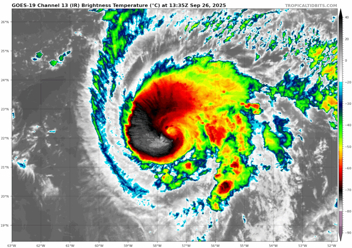
...HUMBERTO RAPIDLY STRENGTHENING OVER THE CENTRAL ATLANTIC...
...EXPECTED TO BECOME A MAJOR HURRICANE LATER TODAY OR ON
SATURDAY...
SUMMARY OF 1100 AM AST...1500 UTC...INFORMATION
-----------------------------------------------
LOCATION...22.3N 57.7W
ABOUT 450 MI...725 KM NE OF THE NORTHERN LEEWARD ISLANDS
MAXIMUM SUSTAINED WINDS...90 MPH...150 KM/H
...EXPECTED TO BECOME A MAJOR HURRICANE LATER TODAY OR ON
SATURDAY...
SUMMARY OF 1100 AM AST...1500 UTC...INFORMATION
-----------------------------------------------
LOCATION...22.3N 57.7W
ABOUT 450 MI...725 KM NE OF THE NORTHERN LEEWARD ISLANDS
MAXIMUM SUSTAINED WINDS...90 MPH...150 KM/H
2 likes
Visit the Caribbean-Central America Weather Thread where you can find at first post web cams,radars
and observations from Caribbean basin members Click Here
and observations from Caribbean basin members Click Here
-
StormWeather
- Category 1
- Posts: 477
- Joined: Wed Jun 05, 2024 2:34 pm
Re: NATL: HUMBERTO - Hurricane - Discussion
kevin wrote:Ehmm
https://i.imgur.com/G43Zstk.jpeg
NHC now forecasting a 125 kt peak. I was thinking earlier that I was too bullish in the poll calling for 135-145 kts for Humberto, but now I think I’m among the few who may end up being right in being bullish.
2 likes
Just an average cyclone tracker
The posts in this forum are NOT official forecasts and should not be used as such. They are just the opinion of the poster and may or may not be backed by sound meteorological data. They are NOT endorsed by any professional institution or storm2k.org. For official information, please refer to the NHC and NWS products
The posts in this forum are NOT official forecasts and should not be used as such. They are just the opinion of the poster and may or may not be backed by sound meteorological data. They are NOT endorsed by any professional institution or storm2k.org. For official information, please refer to the NHC and NWS products
Re: NATL: HUMBERTO - Hurricane - Discussion
sasha_B wrote:Eye temps are positive now. That cleared out shockingly quickly. (Incidentally, ADT has now registered Humberto's evident eye.)
I understand that 1-min meso floaters have more uses than a storm not expected to threaten land, but I simply can't get enough of the 10-min imagery now - the changes are way too dramatic.
Within the past hour alone:
6 likes
TC naming lists: retirements and intensity
Most aggressive Advisory #1's in North Atlantic (cr. kevin for starting the list)
Most aggressive Advisory #1's in North Atlantic (cr. kevin for starting the list)
Who is online
Users browsing this forum: No registered users and 76 guests