NATL: IMELDA - Post-Tropical - Discussion
Moderator: S2k Moderators

Re: NATL: INVEST 94L - Discussion (80/90)
I get the point of expecting a PTC, but some of y’all are acting like NHC is trying to keep this from people when they are very specific every 6 hours with a a TWO that details their expectations and warns people in the path. It would be nice for more clarity on why/when the issue PTCs… but they have other tools and perhaps they’ve received feedback that the PTC seems unnecessary. *shrug*
4 likes
-
TallyTracker
- Category 2

- Posts: 787
- Joined: Thu Oct 11, 2018 2:46 pm
Re: NATL: INVEST 94L - Discussion (80/90)
Buck wrote:I get the point of expecting a PTC, but some of y’all are acting like NHC is trying to keep this from people when they are very specific every 6 hours with a a TWO that details their expectations and warns people in the path. It would be nice for more clarity on why/when the issue PTCs… but they have other tools and perhaps they’ve received feedback that the PTC seems unnecessary. *shrug*
I can see why the NHC would want to wait. People focus on the center of the cone all the time typically. With this level of uncertainty, the initial forecast has a high probability of being wrong. The winds in the Bahamas are looking to be TS force or lower so waiting a model run or two longer to see if the forecast improves seems reasonable to prevent either premature panic or people writing off the threat too soon.
I expect they will issue PTC advisories by 5 pm or 11 pm at the latest if a TD hasn’t formed by then.
1 likes
Fran '96, Georges '98, Gordon '00, Gabrielle '01, Charley '04, Frances '04, Jeanne '04, Barry '07, Fay '08, Debby '12, Matthew '16, Emily '17, Irma '17, Michael ‘18, Elsa ‘21, Fred ‘21, Mindy ‘21, Nicole ‘22, Idalia ‘23, Debby ‘24, Helene ‘24

Re: NATL: INVEST 94L - Discussion (80/90)
Certainly seems to be coalescing near the Windward Passage at all levels.
2 likes
TC naming lists: retirements and intensity
Most aggressive Advisory #1's in North Atlantic (cr. kevin for starting the list)
Most aggressive Advisory #1's in North Atlantic (cr. kevin for starting the list)
-
tolakram
- Admin

- Posts: 20186
- Age: 62
- Joined: Sun Aug 27, 2006 8:23 pm
- Location: Florence, KY (name is Mark)
Re: NATL: INVEST 94L - Discussion (80/90)
I'm not sure we'll even have recon today, where will they go to look?

0 likes
M a r k
- - - - -
Join us in chat: Storm2K Chatroom Invite. Android and IOS apps also available.
The posts in this forum are NOT official forecasts and should not be used as such. Posts are NOT endorsed by any professional institution or STORM2K.org. For official information and forecasts, please refer to NHC and NWS products.
Re: NATL: INVEST 94L - Discussion (80/90)
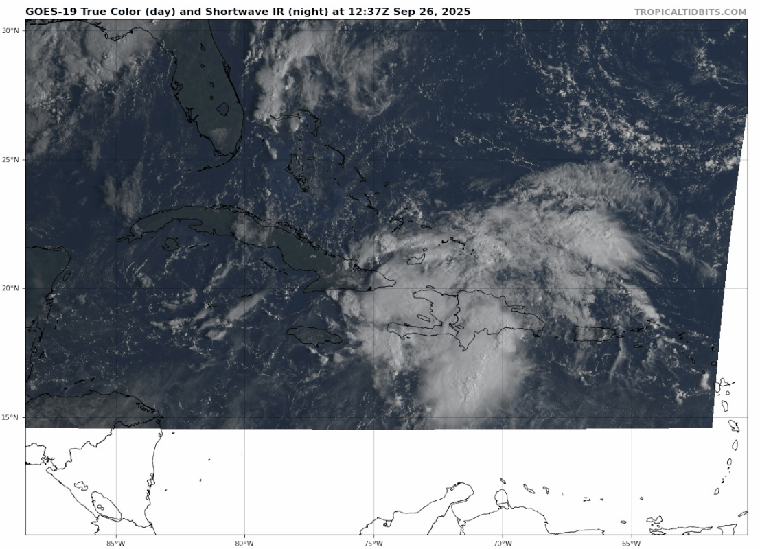
94L is now moving away from Hispaniola but is now getting disrupted by Cuba, as it moves north west over Bahamas later today it should be come more organised. I get the feeling that we are going to have some rapid intensification with the hot waters is about to move over.
GEOS-19 GeoSST 2 Hour Loop

GEOS-19 GeoSST 2 Hour Loop
0 likes
Re: NATL: INVEST 94L - Discussion (80/90)
Buck wrote:I get the point of expecting a PTC, but some of y’all are acting like NHC is trying to keep this from people when they are very specific every 6 hours with a a TWO that details their expectations and warns people in the path. It would be nice for more clarity on why/when the issue PTCs… but they have other tools and perhaps they’ve received feedback that the PTC seems unnecessary. *shrug*
I think part of the issue is the PTC product has been around for a while now and during all this time it has been utilized inconsistently. It isnt quite clear why sometimes a PTC advisory is issued or not. Like wxman said, theyve done it for waves in the past but now they are waiting for a consistent low level vortex in regards to 94L. With such a low-confidence forecast situation, I can understand not wanting to issue cones for the public just yet but we all know the public does not heed local warnings or TWOs compared to actual advisories.
It is quite the conundrum and I dont envy them or other forecasters dealing with this situation.
4 likes
Andrew (1992), Irene (1999), Frances (2004), Katrina (2005), Wilma (2005), Fay (2008), Irma (2017), Eta (2020), Ian (2022)
-
Blown Away

- S2K Supporter

- Posts: 10253
- Joined: Wed May 26, 2004 6:17 am
Re: NATL: INVEST 94L - Discussion (80/90)
The western flank of 94L over Central Cuba is moistening up nicely, the dry air expected from the west is not impacting as of yet.
0 likes
Hurricane Eye Experience: David 79, Irene 99, Frances 04, Jeanne 04, Wilma 05… Hurricane Brush Experience: Andrew 92, Erin 95, Floyd 99, Matthew 16, Irma 17, Ian 22, Nicole 22…

Re: NATL: INVEST 94L - Discussion (80/90)
Just off the NE shore of Great Inagua
21N 73W
Concentrated convection and lightning.
Nice helicity.
Strongest I've seen so far.
Would coincide with the top of the wave axis.
21N 73W
Concentrated convection and lightning.
Nice helicity.
Strongest I've seen so far.
Would coincide with the top of the wave axis.
1 likes
Re: NATL: INVEST 94L - Discussion (80/90)
GCANE wrote:Just off the NE shore of Great Inagua
21N 73W
Concentrated convection and lightning.
Nice helicity.
Strongest I've seen so far.
Would coincide with the top of the wave axis.
Looks like its building higher cirrus (CDO)
1 likes
-
Sciencerocks
- Category 5

- Posts: 10193
- Age: 40
- Joined: Thu Jul 06, 2017 1:51 am

-
Blown Away
- S2K Supporter
- Posts: 10253
- Joined: Wed May 26, 2004 6:17 am
Re: NATL: INVEST 94L - Discussion (80/90)
GCANE wrote:GCANE wrote:Just off the NE shore of Great Inagua
21N 73W
Concentrated convection and lightning.
Nice helicity.
Strongest I've seen so far.
Would coincide with the top of the wave axis.
Looks like its building higher cirrus (CDO)
That would be a big jump back to the north east from the 12Z position. However, the GFS seems to be persistent on a low forming in that area. Is that what you’re trying to say?
0 likes
Hurricane Eye Experience: David 79, Irene 99, Frances 04, Jeanne 04, Wilma 05… Hurricane Brush Experience: Andrew 92, Erin 95, Floyd 99, Matthew 16, Irma 17, Ian 22, Nicole 22…
-
TampaWxLurker
- Tropical Storm

- Posts: 196
- Joined: Thu Aug 01, 2024 8:20 am
Re: NATL: INVEST 94L - Discussion (80/90)
With models showing this approaching/hitting South Carolina in ~90ish hours, NHC needs to tag this as a PTC now before the general public is caught flat-footed.
4 likes


Re: NATL: INVEST 94L - Discussion (80/90)
TampaWxLurker wrote:With models showing this approaching/hitting South Carolina in ~90ish hours, NHC needs to tag this as a PTC now before the general public is caught flat-footed.
My workplace in CHS is holding meetings & engaging in hurricane prep right now - not waiting for warnings/advisories/"the cone". Those whose job it is to pay attention are responding appropriately, I think, but for many it will not feel "real" until the NHC issues graphics. Watches/warnings in SC might not be needed for another 36h or so (if at all) but if nothing else, advisories for the Bahamas & some official comment on track for those in the US southeast would be welcome.
7 likes

Re: NATL: INVEST 94L - Discussion (80/90)
Tough to give a warning when you don't really know who to warn.
4 likes
I'm not a meteorologist, I'm an electronics engineer. While I can probably fix your toaster oven, you're not going to learn about storms from me!
New Mexico had no hurricanes. Then I moved to NC right before Fran.....
New Mexico had no hurricanes. Then I moved to NC right before Fran.....
Re: NATL: INVEST 94L - Discussion (80/90)
Blown Away wrote:GCANE wrote:GCANE wrote:Just off the NE shore of Great Inagua
21N 73W
Concentrated convection and lightning.
Nice helicity.
Strongest I've seen so far.
Would coincide with the top of the wave axis.
Looks like its building higher cirrus (CDO)
That would be a big jump back to the north east from the 12Z position. However, the GFS seems to be persistent on a low forming in that area. Is that what you’re trying to say?
I would say this still a strong wave and is just clearing land interactions.
This convective blow up is a good sign something is trying to form,
0 likes
-
Blown Away
- S2K Supporter
- Posts: 10253
- Joined: Wed May 26, 2004 6:17 am
Re: NATL: INVEST 94L - Discussion (80/90)
GCANE wrote:Blown Away wrote:GCANE wrote: Looks like its building higher cirrus (CDO)
That would be a big jump back to the north east from the 12Z position. However, the GFS seems to be persistent on a low forming in that area. Is that what you’re trying to say?
I would say this still a strong wave and is just clearing land interactions.
This convective blow up is a good sign something is trying to form,
Where would you put the most likely area for it to form now? Would it be farther NW than the 12Z position?
0 likes
Hurricane Eye Experience: David 79, Irene 99, Frances 04, Jeanne 04, Wilma 05… Hurricane Brush Experience: Andrew 92, Erin 95, Floyd 99, Matthew 16, Irma 17, Ian 22, Nicole 22…
Re: NATL: INVEST 94L - Discussion (80/90)
Blown Away wrote:GCANE wrote:Blown Away wrote:
That would be a big jump back to the north east from the 12Z position. However, the GFS seems to be persistent on a low forming in that area. Is that what you’re trying to say?
I would say this still a strong wave and is just clearing land interactions.
This convective blow up is a good sign something is trying to form,
Where would you put the most likely area for it to form now? Would it be farther NW than the 12Z position?
Maybe somewhere west of the island ~21.5N 74.5W around early Saturday morning.
What are your thoughts?
0 likes
-
cycloneye

- Admin
- Posts: 149736
- Age: 69
- Joined: Thu Oct 10, 2002 10:54 am
- Location: San Juan, Puerto Rico
Re: NATL: INVEST 94L - Discussion (90/90) 2 PM= PTC later today
PTC advisories later today.
Tropical Weather Outlook
NWS National Hurricane Center Miami FL
200 PM EDT Fri Sep 26 2025
For the North Atlantic...Caribbean Sea and the Gulf of America:
Active Systems:
The National Hurricane Center is issuing advisories on Hurricane
Humberto, located over the subtropical central Atlantic, and has
issued the last advisory on Post-Tropical cyclone Gabrielle over
the northeastern Atlantic.
1. Southwestern Atlantic (AL94):
Satellite data and surface observations indicate that a low pressure
system appears to be forming near eastern Cuba and the southeastern
Bahamas. This system is producing a large area of disorganized
showers and thunderstorms, and gusty winds. Gradual development of
this system is expected, and it will likely become a tropical
depression during the next day or so while it moves northwestward or
northward across the central and northwestern Bahamas.
Regardless of development, heavy rains and gusty winds are ongoing
in the Dominican Republic, Haiti, the Turks and Caicos Islands, the
southeastern Bahamas and eastern Cuba, and are likely to spread
across the remainder of the Bahamas over the weekend. Interests in
all of these areas should monitor the progress of the system.
Tropical storm watches or warnings could be required for portions of
the Bahamas and advisories on a potential tropical cyclone could be
issued as early as later today. While there remains considerable
uncertainty in the long-range track and intensity of the system,
there is a significant risk of wind, rainfall, and storm surge
impacts for a portion of the southeast U.S. coast early next week.
Interests in this area should also monitor the progress of the
system.
* Formation chance through 48 hours...high...90 percent.
* Formation chance through 7 days...high...90 percent.
Forecaster Cangialosi/Reinhart/Hagen
5 likes
Visit the Caribbean-Central America Weather Thread where you can find at first post web cams,radars
and observations from Caribbean basin members Click Here
and observations from Caribbean basin members Click Here
-
ScottNAtlanta

- Category 5
- Posts: 2535
- Joined: Sat May 25, 2013 3:11 pm
- Location: Atlanta, GA
Re: NATL: INVEST 94L - Discussion (90/90) 2 PM= PTC later today
0 likes
The posts in this forum are NOT official forecast and should not be used as such. They are just the opinion of the poster and may or may not be backed by sound meteorological data. They are NOT endorsed by any professional institution or storm2k.org. For official information, please refer to the NHC and NWS products.
-
DorkyMcDorkface

- Category 5
- Posts: 1046
- Age: 28
- Joined: Mon Sep 30, 2019 1:32 pm
- Location: Mid-Atlantic
Re: NATL: INVEST 94L - Discussion (90/90) 2 PM= PTC later today
2 likes
Please note the thoughts expressed by this account are solely those of the user and are from a hobbyist perspective. For more comprehensive analysis, consult an actual professional meteorologist or meteorological agency.
Floyd 1999 | Isabel 2003 | Hanna 2008 | Irene 2011 | Sandy 2012 | Isaias 2020
Who is online
Users browsing this forum: No registered users and 74 guests