NATL: IMELDA - Models

Moderator: S2k Moderators

Message
Author
shah83
Category 1
Category 1
Posts: 306
Joined: Sun Jul 31, 2016 4:55 pm

Re: NATL: INVEST 94L - Models

#241 Postby shah83 » Fri Sep 26, 2025 11:24 am

Teban54 wrote:Looks like the slowdown on 12z GFS (compared to its own runs earlier) makes things even more problematic, as it (1) gives 94L more time to strengthen before landfall, and (2) allows for a more explicit stall due to shorter distance to Humberto, while maintaining higher intensity and thus rainfall potential during the stall.


Yeah, you're right. 12z GFZ essentially replicates the 2015 SC flood situation with Hurricane Joaquin providing the moisture.
0 likes   

tolakram
Admin
Admin
Posts: 20126
Age: 62
Joined: Sun Aug 27, 2006 8:23 pm
Location: Florence, KY (name is Mark)

Re: NATL: INVEST 94L - Models

#242 Postby tolakram » Fri Sep 26, 2025 11:32 am

12Z GFS
Image
2 likes   
M a r k
- - - - -
Join us in chat: Storm2K Chatroom Invite. Android and IOS apps also available.

The posts in this forum are NOT official forecasts and should not be used as such. Posts are NOT endorsed by any professional institution or STORM2K.org. For official information and forecasts, please refer to NHC and NWS products.

Stratton23
Category 5
Category 5
Posts: 2827
Joined: Fri Jul 21, 2023 10:59 pm
Location: Katy, Tx

Re: NATL: INVEST 94L - Models

#243 Postby Stratton23 » Fri Sep 26, 2025 11:38 am

CMC is wonky, very complex pattern with ridging trying to trap/ stall out 94L
0 likes   

LarryWx
S2K Supporter
S2K Supporter
Posts: 6830
Joined: Sun Sep 07, 2003 2:04 pm
Location: GA

Re: NATL: INVEST 94L - Models

#244 Postby LarryWx » Fri Sep 26, 2025 11:54 am

12Z:
CMC hits NC after the loop.

UKMET goes OTS again like the Icon

NEW TROPICAL CYCLONE FORECAST TO DEVELOP AFTER 42 HOURS
FORECAST POSITION AT T+ 42 : 23.3N 76.7W

LEAD CENTRAL MAXIMUM WIND
VERIFYING TIME TIME POSITION PRESSURE (MB) SPEED (KNOTS)
-------------- ---- -------- ------------- -------------
1200UTC 28.09.2025 48 24.2N 76.7W 1007 33
0000UTC 29.09.2025 60 25.2N 77.4W 1004 34
1200UTC 29.09.2025 72 26.7N 77.8W 1003 38
0000UTC 30.09.2025 84 28.2N 77.6W 1001 36
1200UTC 30.09.2025 96 28.9N 78.5W 996 42
0000UTC 01.10.2025 108 28.7N 77.8W 994 40
1200UTC 01.10.2025 120 28.5N 76.6W 992 38
0000UTC 02.10.2025 132 28.7N 74.3W 991 46
1200UTC 02.10.2025 144 28.9N 72.2W 991 54
0000UTC 03.10.2025 156 28.7N 69.6W 992 63
1200UTC 03.10.2025 168 28.6N 68.4W 995 52
0 likes   
Personal Forecast Disclaimer:
The posts in this forum are NOT official forecasts and should not be used as such. They are just the opinion of the poster and may or may not be backed by sound meteorological data. They are NOT endorsed by any professional institution or storm2k.org. For official information, please refer to the NHC and NWS products.

BobHarlem
Category 5
Category 5
Posts: 2535
Joined: Thu Oct 20, 2005 6:11 pm

Re: NATL: INVEST 94L - Models

#245 Postby BobHarlem » Fri Sep 26, 2025 12:09 pm

12z cmc delayed landfall

Image
1 likes   

MEANINGLESS_NUMBERS
Category 1
Category 1
Posts: 450
Joined: Mon Nov 02, 2020 1:43 pm

Re: NATL: INVEST 94L - Models

#246 Postby MEANINGLESS_NUMBERS » Fri Sep 26, 2025 12:26 pm


That’s 24 inches of rain in Wilmington, NC.

GFS has 24++ on Atlanta though so idk which is worse.
1 likes   
Emily '87, Felix '95, Gert '99, Fabian '03, Humberto '19, Paulette '20, Teddy '20, Fiona '22, Lee '23, Ernesto '24, Humberto/Imelda '25

LarryWx
S2K Supporter
S2K Supporter
Posts: 6830
Joined: Sun Sep 07, 2003 2:04 pm
Location: GA

Re: NATL: INVEST 94L - Models

#247 Postby LarryWx » Fri Sep 26, 2025 12:53 pm

12Z Euro gets close to CHS, but does it then stall? I’m not sure.
0 likes   
Personal Forecast Disclaimer:
The posts in this forum are NOT official forecasts and should not be used as such. They are just the opinion of the poster and may or may not be backed by sound meteorological data. They are NOT endorsed by any professional institution or storm2k.org. For official information, please refer to the NHC and NWS products.

tolakram
Admin
Admin
Posts: 20126
Age: 62
Joined: Sun Aug 27, 2006 8:23 pm
Location: Florence, KY (name is Mark)

Re: NATL: INVEST 94L - Models

#248 Postby tolakram » Fri Sep 26, 2025 12:58 pm

0 likes   
M a r k
- - - - -
Join us in chat: Storm2K Chatroom Invite. Android and IOS apps also available.

The posts in this forum are NOT official forecasts and should not be used as such. Posts are NOT endorsed by any professional institution or STORM2K.org. For official information and forecasts, please refer to NHC and NWS products.

User avatar
SFLcane
S2K Supporter
S2K Supporter
Posts: 10279
Age: 47
Joined: Sat Jun 05, 2010 1:44 pm
Location: Lake Worth Florida

Re: NATL: INVEST 94L - Models

#249 Postby SFLcane » Fri Sep 26, 2025 1:03 pm

New hafs gets fairly close to the florida eastcoast. One of those times to stress a tc is not a dot on a map the affects always extend far out from any given center. The cone only covers were the center is going to be.

Could potential bring squally rainbands onshore depending how close it gets.

Image

Image
Last edited by SFLcane on Fri Sep 26, 2025 1:29 pm, edited 1 time in total.
7 likes   

shah83
Category 1
Category 1
Posts: 306
Joined: Sun Jul 31, 2016 4:55 pm

Re: NATL: INVEST 94L - Models

#250 Postby shah83 » Fri Sep 26, 2025 1:07 pm

dynamic models showing stalls
0 likes   

User avatar
Travorum
Category 2
Category 2
Posts: 547
Joined: Tue Sep 05, 2023 9:36 am
Location: Dunedin, FL

Re: NATL: INVEST 94L - Models

#251 Postby Travorum » Fri Sep 26, 2025 1:08 pm

12z Euro drops 20+ inches along most of the coast of the Carolinas including a monstrous 27.5 inches on Charleston.

Image
4 likes   

User avatar
chaser1
S2K Supporter
S2K Supporter
Posts: 5718
Age: 64
Joined: Sat Oct 15, 2005 5:59 pm
Location: Longwood, Fl

Re: NATL: INVEST 94L - Models

#252 Postby chaser1 » Fri Sep 26, 2025 1:29 pm

dexterlabio wrote:I don't really follow the ATL basin that much but I'm interested in the cases of classic Fujiwara effect between two hurricanes in this part of the world. The examples that I often see are those from the Western Pacific, but with future Imelda and Humberto there is a chance of having one for the Atlantic. Although the latest model runs do not show the "dancing TCs" scenario, yet.


Welcome! Come for the fujiwhara; stay for the drinks lol.
Let me ask you.... considering your particular interest and focus on tropical cyclone fujiwhara events (primarily from other basins), do you find that one particular model seems to excel in terms of better forecasting their interaction?
1 likes   
Andy D

(For official information, please refer to the NHC and NWS products.)

User avatar
wzrgirl1
S2K Supporter
S2K Supporter
Posts: 1360
Joined: Sat Sep 04, 2004 6:44 am
Location: Pembroke Pines, Florida

Re: NATL: INVEST 94L - Models

#253 Postby wzrgirl1 » Fri Sep 26, 2025 1:29 pm

SFLcane wrote:New hafs gets fairly close to the florida eastcoast. One of those times to stress a tc is not a dot on a map the affects always extend far out from any given center. The cone only covers were the center is going to be.

Potential squally rainbands..

https://i.postimg.cc/y8rth3pk/vvvvvvll.png

https://i.postimg.cc/gjDBxx62/ccc.png


That has been my concern is a stall and the ridge building back in forcing the storm west before it makes the north trajectory.
4 likes   

User avatar
boca
Category 5
Category 5
Posts: 6398
Age: 61
Joined: Mon Dec 15, 2003 8:49 am
Location: Boca Raton,FL

Re: NATL: INVEST 94L - Models

#254 Postby boca » Fri Sep 26, 2025 1:45 pm

wzrgirl1 wrote:
SFLcane wrote:New hafs gets fairly close to the florida eastcoast. One of those times to stress a tc is not a dot on a map the affects always extend far out from any given center. The cone only covers were the center is going to be.

Potential squally rainbands..

https://i.postimg.cc/y8rth3pk/vvvvvvll.png

https://i.postimg.cc/gjDBxx62/ccc.png


That has been my concern is a stall and the ridge building back in forcing the storm west before it makes the north trajectory.


The cold front advancing thru N Florida so hopefully that will maybe deflect it away.
2 likes   

User avatar
Blown Away
S2K Supporter
S2K Supporter
Posts: 10225
Joined: Wed May 26, 2004 6:17 am

Re: NATL: INVEST 94L - Models

#255 Postby Blown Away » Fri Sep 26, 2025 1:57 pm

Image

AL, 94, 2025092618, , BEST, 0, 207N, 744W, 30, 1008, DB


GFS has been persistent with that 18-24 position run after run and it initializes near the 18z position then jumps NE??
1 likes   
Hurricane Eye Experience: David 79, Irene 99, Frances 04, Jeanne 04, Wilma 05… Hurricane Brush Experience: Andrew 92, Erin 95, Floyd 99, Matthew 16, Irma 17, Ian 22, Nicole 22…

CycloysisNegative
Tropical Low
Tropical Low
Posts: 27
Joined: Fri Jul 05, 2024 11:36 am
Location: Summerville, SC

Re: NATL: INVEST 94L - Models

#256 Postby CycloysisNegative » Fri Sep 26, 2025 2:33 pm

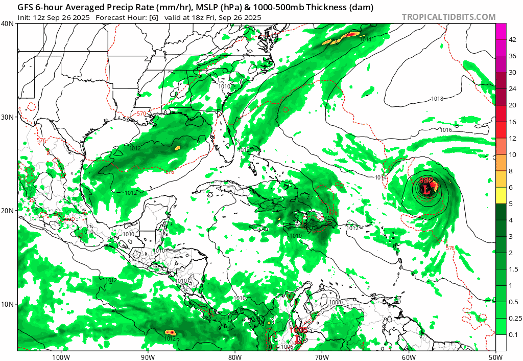
Blown Away wrote: https://i.postimg.cc/v813V8p8/gfs-mslp- ... fh6-24.gif

AL, 94, 2025092618, , BEST, 0, 207N, 744W, 30, 1008, DB


GFS has been persistent with that 18-24 position run after run and it initializes near the 18z position then jumps NE??


That’s probably an artifact of the algorithm used by TT (or any site for that matter). I’ve been building my own application that grabs the GFS data and plots it.

For displaying the “L” and the pressure, he has it coded somewhere to display it under some circumstance (e.g., If mslp < 1010mb), to avoid a bunch of them popping up all over it likely also sets a boundary, something like display the lowest pressure under a certain threshold in a 100mi radius (made up those numbers but you get the idea).

So it’s not that the system jumps, or that the GFS is doing something wonky, it’s that the area to the NE becomes the dominant mslp/vorticity position in that “boundary”. Hence the L disappears and reappears to the NE.


The GFS and any other model just provides the raw numbers, it’s up to a programmer on how to display it.
4 likes   

User avatar
Blown Away
S2K Supporter
S2K Supporter
Posts: 10225
Joined: Wed May 26, 2004 6:17 am

Re: NATL: INVEST 94L - Models

#257 Postby Blown Away » Fri Sep 26, 2025 3:30 pm

CycloysisNegative wrote:
Blown Away wrote:[url]https://i.postimg.cc/v813V8p8/gfs-mslp-pcpn-watl-fh6-24.gif [/url]

AL, 94, 2025092618, , BEST, 0, 207N, 744W, 30, 1008, DB


GFS has been persistent with that 18-24 position run after run and it initializes near the 18z position then jumps NE??


That’s probably an artifact of the algorithm used by TT (or any site for that matter). I’ve been building my own application that grabs the GFS data and plots it.

For displaying the “L” and the pressure, he has it coded somewhere to display it under some circumstance (e.g., If mslp < 1010mb), to avoid a bunch of them popping up all over it likely also sets a boundary, something like display the lowest pressure under a certain threshold in a 100mi radius (made up those numbers but you get the idea).

So it’s not that the system jumps, or that the GFS is doing something wonky, it’s that the area to the NE becomes the dominant mslp/vorticity position in that “boundary”. Hence the L disappears and reappears to the NE.


The GFS and any other model just provides the raw numbers, it’s up to a programmer on how to display it.


Wow, thank you for this great summary!
1 likes   
Hurricane Eye Experience: David 79, Irene 99, Frances 04, Jeanne 04, Wilma 05… Hurricane Brush Experience: Andrew 92, Erin 95, Floyd 99, Matthew 16, Irma 17, Ian 22, Nicole 22…

User avatar
ScottNAtlanta
Category 5
Category 5
Posts: 2484
Joined: Sat May 25, 2013 3:11 pm
Location: Atlanta, GA

Re: NATL: INVEST 94L - Models

#258 Postby ScottNAtlanta » Fri Sep 26, 2025 3:34 pm

MEANINGLESS_NUMBERS wrote:


That’s 24 inches of rain in Wilmington, NC.

GFS has 24++ on Atlanta though so idk which is worse.

Where did you see 24 ++ in Atlanta??? I think that was 2.4
0 likes   
The posts in this forum are NOT official forecast and should not be used as such. They are just the opinion of the poster and may or may not be backed by sound meteorological data. They are NOT endorsed by any professional institution or storm2k.org. For official information, please refer to the NHC and NWS products.

User avatar
ScottNAtlanta
Category 5
Category 5
Posts: 2484
Joined: Sat May 25, 2013 3:11 pm
Location: Atlanta, GA

Re: NATL: NINE - Models

#259 Postby ScottNAtlanta » Fri Sep 26, 2025 3:40 pm

I think the gist of the track is that if 94L has a higher latitude than Humberto, your odds of a landfall are relatively high. If it is at a lower latitude, those odds go down quite a bit, but a landfall is still possible. Every scenario I've seem in the models with the first scenario landfall
3 likes   
The posts in this forum are NOT official forecast and should not be used as such. They are just the opinion of the poster and may or may not be backed by sound meteorological data. They are NOT endorsed by any professional institution or storm2k.org. For official information, please refer to the NHC and NWS products.

User avatar
cycloneye
Admin
Admin
Posts: 148043
Age: 69
Joined: Thu Oct 10, 2002 10:54 am
Location: San Juan, Puerto Rico

Re: NATL: NINE - Models

#260 Postby cycloneye » Fri Sep 26, 2025 3:47 pm

Important part of the 5 PM discussion regarding the models.


It should be emphasized that the long-range intensity forecast depends
largely on where the system is and the degree of land interaction at those
periods, and therefore, is of low confidence. Given the higher-than-usual
uncertainty in the forecast track and intensity of the system, NOAA Hurricane
Hunter aircraft have been collecting data over the western Atlantic since
yesterday, and additional upper-air launches are occurring. This data collection
will continue through the weekend to help improve the model guidance for this
system.
2 likes   
Visit the Caribbean-Central America Weather Thread where you can find at first post web cams,radars
and observations from Caribbean basin members Click Here


Return to “2025”

Who is online

Users browsing this forum: No registered users and 43 guests