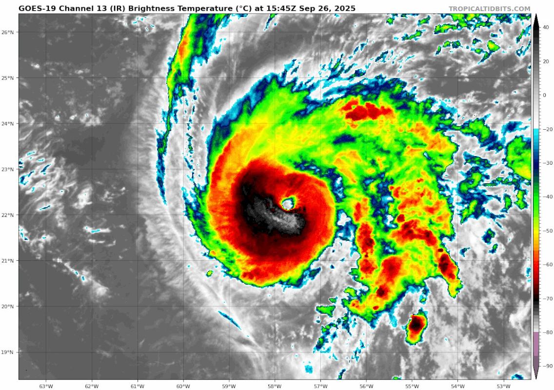
NATL: HUMBERTO - Remnants - Discussion

Moderator: S2k Moderators

Message
Author
MarioProtVI
Category 5
Category 5
Posts: 1002
Age: 24
Joined: Sun Sep 29, 2019 7:33 pm
Location: New Jersey

Re: NATL: HUMBERTO - Hurricane - Discussion

#161 Postby MarioProtVI » Fri Sep 26, 2025 3:29 pm

USTropics wrote:
tolakram wrote:
aspen wrote:The lack of attention Humberto — and 94L, to a lesser extent — are getting is so odd. No posted recon plans for Humberto nor meso sectors for either yet. At least we had a low-level and an upper-level flight, but I’d expect much more recon activity than what we’re seeing.


Why? 94L is more important at the moment as it threatens landfall. These are exciting systems but recon doesn't run just to satisfy our curiosity. They will be VERY busy over the next few days, I would delay as long as possible.


Can confirm this is exactly what NHC is doing. There is an untasked recon flight for Humberto later this evening (per my sources). They will be flying into Humberto as the system approaches Bermuda, but for now 94L remains somewhat more of a mystery (how does it interact with the ULL over the Southeast, how does shear and dry air subsidence dump from Humberto impact development, etc.). A lot of uncertainty in the models, which is why we need moar data.

Is this going to be an untasked center pass? Because if so they could actually catch Humberto as it’s peaking.
2 likes   

User avatar
cycloneye
Admin
Admin
Posts: 147755
Age: 69
Joined: Thu Oct 10, 2002 10:54 am
Location: San Juan, Puerto Rico

Re: NATL: HUMBERTO - Hurricane - Discussion

#162 Postby cycloneye » Fri Sep 26, 2025 3:36 pm

500 PM AST Fri Sep 26 2025

...HUMBERTO RAPIDLY STRENGTHENS TO A MAJOR HURRICANE...
...FURTHER INTENSIFICATION EXPECTED OVER THE CENTRAL ATLANTIC...
5 likes   
Visit the Caribbean-Central America Weather Thread where you can find at first post web cams,radars
and observations from Caribbean basin members Click Here

User avatar
Teban54
Category 5
Category 5
Posts: 3524
Joined: Sat May 19, 2018 1:19 pm

Re: NATL: HUMBERTO - Hurricane - Discussion

#163 Postby Teban54 » Fri Sep 26, 2025 3:46 pm

Image
2 likes   

User avatar
Travorum
Category 2
Category 2
Posts: 536
Joined: Tue Sep 05, 2023 9:36 am
Location: Dunedin, FL

Re: NATL: HUMBERTO - Hurricane - Discussion

#164 Postby Travorum » Fri Sep 26, 2025 3:47 pm

NHC is now forecasting 130kts.

FORECAST POSITIONS AND MAX WINDS

INIT 26/2100Z 22.3N 58.1W 100 KT 115 MPH
12H 27/0600Z 22.4N 59.0W 115 KT 130 MPH
24H 27/1800Z 22.8N 60.5W 125 KT 145 MPH
36H 28/0600Z 23.4N 62.4W 130 KT 150 MPH
48H 28/1800Z 24.6N 64.3W 125 KT 145 MPH
60H 29/0600Z 26.0N 66.0W 120 KT 140 MPH
72H 29/1800Z 27.7N 67.5W 115 KT 130 MPH
96H 30/1800Z 31.7N 68.8W 100 KT 115 MPH
120H 01/1800Z 35.5N 63.5W 90 KT 105 MPH
1 likes   

User avatar
StormWeather
Category 1
Category 1
Posts: 442
Joined: Wed Jun 05, 2024 2:34 pm

Re: NATL: HUMBERTO - Hurricane - Discussion

#165 Postby StormWeather » Fri Sep 26, 2025 3:50 pm

Travorum wrote:NHC is now forecasting 130kts.

FORECAST POSITIONS AND MAX WINDS

INIT 26/2100Z 22.3N 58.1W 100 KT 115 MPH
12H 27/0600Z 22.4N 59.0W 115 KT 130 MPH
24H 27/1800Z 22.8N 60.5W 125 KT 145 MPH
36H 28/0600Z 23.4N 62.4W 130 KT 150 MPH
48H 28/1800Z 24.6N 64.3W 125 KT 145 MPH
60H 29/0600Z 26.0N 66.0W 120 KT 140 MPH
72H 29/1800Z 27.7N 67.5W 115 KT 130 MPH
96H 30/1800Z 31.7N 68.8W 100 KT 115 MPH
120H 01/1800Z 35.5N 63.5W 90 KT 105 MPH

I was expecting them to do this when the 18Z intensity guidance came out on CyclonicWx.
1 likes   
Just an average cyclone tracker

The posts in this forum are NOT official forecasts and should not be used as such. They are just the opinion of the poster and may or may not be backed by sound meteorological data. They are NOT endorsed by any professional institution or storm2k.org. For official information, please refer to the NHC and NWS products

User avatar
Travorum
Category 2
Category 2
Posts: 536
Joined: Tue Sep 05, 2023 9:36 am
Location: Dunedin, FL

Re: NATL: HUMBERTO - Hurricane - Discussion

#166 Postby Travorum » Fri Sep 26, 2025 4:50 pm

Sunset on Humberto:

Image
6 likes   

User avatar
sasha_B
Tropical Storm
Tropical Storm
Posts: 196
Age: 24
Joined: Sun Jun 30, 2024 4:32 pm
Location: Charleston, SC

Re: NATL: HUMBERTO - Hurricane - Discussion

#167 Postby sasha_B » Fri Sep 26, 2025 5:13 pm

Raw T#s for Humberto are up to 6.4 with the final CI approaching 6.0; it's likely at or near Category 4 despite officially just reaching Category 3 an hour ago. Either way, intensification has been rapid indeed: officially, 50 kts in 24 hours, plausibly closer to 60~65 kts, with the corresponding drop in pressure being somewhere between 38~50 hPa over the same 24h period. This season, despite its below-average ACE/storm count to date, is 3-for-3 on hurricanes dramatically overperforming their initial forecasts.
7 likes   

User avatar
abajan
S2K Supporter
S2K Supporter
Posts: 4292
Age: 61
Joined: Sun Sep 07, 2003 5:10 am
Location: Barbados

Re: NATL: HUMBERTO - Hurricane - Discussion

#168 Postby abajan » Fri Sep 26, 2025 5:15 pm

Dr. Cowan's latest video:


Link: https://youtu.be/pjDQVhvT4Ms
0 likes   

User avatar
Teban54
Category 5
Category 5
Posts: 3524
Joined: Sat May 19, 2018 1:19 pm

Re: NATL: HUMBERTO - Hurricane - Discussion

#169 Postby Teban54 » Fri Sep 26, 2025 5:26 pm

The eye is rapidly improving (again):

Image
4 likes   

User avatar
Travorum
Category 2
Category 2
Posts: 536
Joined: Tue Sep 05, 2023 9:36 am
Location: Dunedin, FL

Re: NATL: HUMBERTO - Hurricane - Discussion

#170 Postby Travorum » Fri Sep 26, 2025 5:40 pm

There's CI# 6.0 on ADT:

UW - CIMSS
ADVANCED DVORAK TECHNIQUE
ADT-Version 9.1
Tropical Cyclone Intensity Algorithm

----- Current Analysis -----
Date : 26 SEP 2025 Time : 221019 UTC
Lat : 22:07:47 N Lon : 58:15:35 W


CI# /Pressure/ Vmax
6.0 / 947.4mb/115.0kt


Final T# Adj T# Raw T#
6.0 6.3 6.4

Estimated radius of max. wind based on IR : 15 km

Center Temp : +13.3C Cloud Region Temp : -68.5C
1 likes   

User avatar
StormWeather
Category 1
Category 1
Posts: 442
Joined: Wed Jun 05, 2024 2:34 pm

Re: NATL: HUMBERTO - Hurricane - Discussion

#171 Postby StormWeather » Fri Sep 26, 2025 5:41 pm

Travorum wrote:There's CI# 6.0 on ADT:

UW - CIMSS
ADVANCED DVORAK TECHNIQUE
ADT-Version 9.1
Tropical Cyclone Intensity Algorithm

----- Current Analysis -----
Date : 26 SEP 2025 Time : 221019 UTC
Lat : 22:07:47 N Lon : 58:15:35 W


CI# /Pressure/ Vmax
6.0 / 947.4mb/115.0kt


Final T# Adj T# Raw T#
6.0 6.3 6.4

Estimated radius of max. wind based on IR : 15 km

Center Temp : +13.3C Cloud Region Temp : -68.5C

So pretty much a raw instantaneous Category 4 off of that?! It literally was just a Tropical Storm this morning!
0 likes   
Just an average cyclone tracker

The posts in this forum are NOT official forecasts and should not be used as such. They are just the opinion of the poster and may or may not be backed by sound meteorological data. They are NOT endorsed by any professional institution or storm2k.org. For official information, please refer to the NHC and NWS products

User avatar
Travorum
Category 2
Category 2
Posts: 536
Joined: Tue Sep 05, 2023 9:36 am
Location: Dunedin, FL

Re: NATL: HUMBERTO - Hurricane - Discussion

#172 Postby Travorum » Fri Sep 26, 2025 5:51 pm

StormWeather wrote:
Travorum wrote:There's CI# 6.0 on ADT:

UW - CIMSS
ADVANCED DVORAK TECHNIQUE
ADT-Version 9.1
Tropical Cyclone Intensity Algorithm

----- Current Analysis -----
Date : 26 SEP 2025 Time : 221019 UTC
Lat : 22:07:47 N Lon : 58:15:35 W


CI# /Pressure/ Vmax
6.0 / 947.4mb/115.0kt


Final T# Adj T# Raw T#
6.0 6.3 6.4

Estimated radius of max. wind based on IR : 15 km

Center Temp : +13.3C Cloud Region Temp : -68.5C

So pretty much a raw instantaneous Category 4 off of that?! It literally was just a Tropical Storm this morning!


Not even raw instantaneous, this is the sustained trend. Raw T# has been above 6.0 (115kts/Cat 4) for 2 hours. Quite the impressive intensification over the day!
4 likes   

User avatar
StormWeather
Category 1
Category 1
Posts: 442
Joined: Wed Jun 05, 2024 2:34 pm

Re: NATL: HUMBERTO - Hurricane - Discussion

#173 Postby StormWeather » Fri Sep 26, 2025 5:54 pm

Travorum wrote:
StormWeather wrote:
Travorum wrote:There's CI# 6.0 on ADT:

UW - CIMSS
ADVANCED DVORAK TECHNIQUE
ADT-Version 9.1
Tropical Cyclone Intensity Algorithm

----- Current Analysis -----
Date : 26 SEP 2025 Time : 221019 UTC
Lat : 22:07:47 N Lon : 58:15:35 W


CI# /Pressure/ Vmax
6.0 / 947.4mb/115.0kt


Final T# Adj T# Raw T#
6.0 6.3 6.4

Estimated radius of max. wind based on IR : 15 km

Center Temp : +13.3C Cloud Region Temp : -68.5C

So pretty much a raw instantaneous Category 4 off of that?! It literally was just a Tropical Storm this morning!


Not even raw instantaneous, this is the sustained trend. Raw T# has been above 6.0 (115kts/Cat 4) for 2 hours. Quite the impressive intensification over the day!

So from 50 kts this morning to potentially 115-120 kts by tomorrow morning UTC? Omg
2 likes   
Just an average cyclone tracker

The posts in this forum are NOT official forecasts and should not be used as such. They are just the opinion of the poster and may or may not be backed by sound meteorological data. They are NOT endorsed by any professional institution or storm2k.org. For official information, please refer to the NHC and NWS products

User avatar
Beef Stew
Category 2
Category 2
Posts: 533
Joined: Sat May 30, 2020 11:31 am
Location: South Florida

Re: NATL: HUMBERTO - Hurricane - Discussion

#174 Postby Beef Stew » Fri Sep 26, 2025 6:03 pm

We’re (quite likely) about to have the first three hurricanes of this season all peak at 120 kts or more… quite an unusual feat.
7 likes   

zzzh
Category 4
Category 4
Posts: 938
Joined: Thu Sep 02, 2021 1:13 pm

Re: NATL: HUMBERTO - Hurricane - Discussion

#175 Postby zzzh » Fri Sep 26, 2025 6:11 pm

Humberto is moving to the SW.
1 likes   

User avatar
Travorum
Category 2
Category 2
Posts: 536
Joined: Tue Sep 05, 2023 9:36 am
Location: Dunedin, FL

Re: NATL: HUMBERTO - Hurricane - Discussion

#176 Postby Travorum » Fri Sep 26, 2025 6:12 pm

If you broke constraints this would be DT6.5. If that W ring gets a little thicker...

Image
Last edited by Travorum on Fri Sep 26, 2025 6:45 pm, edited 1 time in total.
3 likes   

User avatar
storm_in_a_teacup
Category 1
Category 1
Posts: 468
Age: 33
Joined: Wed Aug 16, 2017 5:01 pm
Location: Huntsville, Alabama (originally from Houston)
Contact:

Re: NATL: HUMBERTO - Hurricane - Discussion

#177 Postby storm_in_a_teacup » Fri Sep 26, 2025 6:28 pm

sasha_B wrote:Raw T#s for Humberto are up to 6.4 with the final CI approaching 6.0; it's likely at or near Category 4 despite :eek: officially just reaching Category 3 an hour ago. Either way, intensification has been rapid indeed: officially, 50 kts in 24 hours, plausibly closer to 60~65 kts, with the corresponding drop in pressure being somewhere between 38~50 hPa over the same 24h period. This season, despite its below-average ACE/storm count to date, is 3-for-3 on hurricanes dramatically overperforming their initial forecasts.


Oh wow how my boy has grown :eek:
2 likes   
I know I can't straddle the atmosphere...just a tiny storm in your teacup, girl.

User avatar
cheezyWXguy
Category 5
Category 5
Posts: 6171
Joined: Mon Feb 13, 2006 12:29 am
Location: Dallas, TX

Re: NATL: HUMBERTO - Hurricane - Discussion

#178 Postby cheezyWXguy » Fri Sep 26, 2025 6:31 pm

Shame we won’t have recon for a while, though I understand why. I’d be shocked if this wasn’t officially a cat4 by the 11pm advisory
3 likes   

User avatar
cheezyWXguy
Category 5
Category 5
Posts: 6171
Joined: Mon Feb 13, 2006 12:29 am
Location: Dallas, TX

Re: NATL: HUMBERTO - Hurricane - Discussion

#179 Postby cheezyWXguy » Fri Sep 26, 2025 6:54 pm

I also wonder if Humberto will go through an ewrc soon. IR seems to give hints that it might happen soon? Plus I recall some model runs from earlier that show Humberto transitioning to an annular structure at some point with a larger eye, so it seems plausible to me.
0 likes   

zzzh
Category 4
Category 4
Posts: 938
Joined: Thu Sep 02, 2021 1:13 pm

Re: NATL: HUMBERTO - Hurricane - Discussion

#180 Postby zzzh » Fri Sep 26, 2025 6:59 pm

cheezyWXguy wrote:I also wonder if Humberto will go through an ewrc soon. IR seems to give hints that it might happen soon? Plus I recall some model runs from earlier that show Humberto transitioning to an annular structure at some point with a larger eye, so it seems plausible to me.

Image
7 likes   


Return to “2025”

Who is online

Users browsing this forum: No registered users and 52 guests