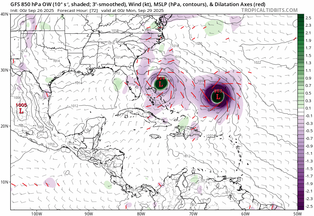
NATL: IMELDA - Models

Moderator: S2k Moderators

Message
Author
Coolcruiseman
Tropical Depression
Tropical Depression
Posts: 97
Age: 51
Joined: Wed Sep 21, 2022 8:10 pm
Location: Melbourne, FL

Re: NATL: INVEST 94L - Models

#261 Postby Coolcruiseman » Fri Sep 26, 2025 3:54 pm

boca wrote:
wzrgirl1 wrote:
SFLcane wrote:New hafs gets fairly close to the florida eastcoast. One of those times to stress a tc is not a dot on a map the affects always extend far out from any given center. The cone only covers were the center is going to be.

Potential squally rainbands..

https://i.postimg.cc/y8rth3pk/vvvvvvll.png

https://i.postimg.cc/gjDBxx62/ccc.png


That has been my concern is a stall and the ridge building back in forcing the storm west before it makes the north trajectory.


The cold front advancing thru N Florida so hopefully that will maybe deflect it away.


The front is forecast to stall late Saturday so where it stalls is going to determine to what degree it deflects.
0 likes   

BobHarlem
Category 5
Category 5
Posts: 2535
Joined: Thu Oct 20, 2005 6:11 pm

Re: NATL: NINE - Models

#262 Postby BobHarlem » Fri Sep 26, 2025 5:07 pm

18z GFS is stalling the system offshore (similar to the NHC track) May be leaning toward icon/cmc now.
2 likes   

User avatar
JtSmarts
S2K Supporter
S2K Supporter
Posts: 1442
Age: 39
Joined: Thu Jul 10, 2003 1:29 pm
Location: Columbia, South Carolina

Re: NATL: NINE - Models

#263 Postby JtSmarts » Fri Sep 26, 2025 5:13 pm

This could end up being another big win for the icon, still a few more days of models cycles to go.
4 likes   

TampaWxLurker
Tropical Storm
Tropical Storm
Posts: 195
Joined: Thu Aug 01, 2024 8:20 am

Re: NATL: NINE - Models

#264 Postby TampaWxLurker » Fri Sep 26, 2025 5:13 pm

The trend is your friend in this instance. First GFS slowed it down and stalled inland, now slows it down further enough for Humberto to catch up.

If that solution ends up verifying, but kudos to the Icon.
1 likes   

Pelicane
Tropical Storm
Tropical Storm
Posts: 184
Joined: Tue Sep 13, 2022 1:52 pm
Location: Lafayette, Louisiana

Re: NATL: NINE - Models

#265 Postby Pelicane » Fri Sep 26, 2025 5:24 pm

That would be far enough offshore that the heaviest rain would be over the ocean.
1 likes   

User avatar
Blown Away
S2K Supporter
S2K Supporter
Posts: 10225
Joined: Wed May 26, 2004 6:17 am

Re: NATL: NINE - Models

#266 Postby Blown Away » Fri Sep 26, 2025 6:06 pm

Image
18z GFS Trend closer to SFL.
0 likes   
Hurricane Eye Experience: David 79, Irene 99, Frances 04, Jeanne 04, Wilma 05… Hurricane Brush Experience: Andrew 92, Erin 95, Floyd 99, Matthew 16, Irma 17, Ian 22, Nicole 22…

BobHarlem
Category 5
Category 5
Posts: 2535
Joined: Thu Oct 20, 2005 6:11 pm

Re: NATL: NINE - Models

#267 Postby BobHarlem » Fri Sep 26, 2025 6:39 pm

18z Euro AI doesn't hit SC, but does make landfall in the OBX and goes up the Chesapeake Bay.

Image
2 likes   

LarryWx
S2K Supporter
S2K Supporter
Posts: 6830
Joined: Sun Sep 07, 2003 2:04 pm
Location: GA

Re: NATL: NINE - Models

#268 Postby LarryWx » Fri Sep 26, 2025 7:07 pm

TampaWxLurker wrote:The trend is your friend in this instance. First GFS slowed it down and stalled inland, now slows it down further enough for Humberto to catch up.

If that solution ends up verifying, but kudos to the Icon.


Not only the Icon but also the UKMET, which has still not yet had a single run with a conus landfall!
4 likes   
Personal Forecast Disclaimer:
The posts in this forum are NOT official forecasts and should not be used as such. They are just the opinion of the poster and may or may not be backed by sound meteorological data. They are NOT endorsed by any professional institution or storm2k.org. For official information, please refer to the NHC and NWS products.

Powellrm
Tropical Storm
Tropical Storm
Posts: 110
Joined: Sun Sep 03, 2017 1:40 pm

Re: NATL: NINE - Models

#269 Postby Powellrm » Fri Sep 26, 2025 7:15 pm

I am a big advocate the ICON model, and this would be another great call by ICON. It’s certainly off here and there, but ICON has had a history of nailing some complex systems early on in the process, and sticking to its data. This would be one of the wildest wins for ICON. Also, as a Carolinian who got 4 feet of water in his house from Chantal, the ICON’s fujiwhara effect solution would be a huge relief.
1 likes   

BobHarlem
Category 5
Category 5
Posts: 2535
Joined: Thu Oct 20, 2005 6:11 pm

Re: NATL: NINE - Models

#270 Postby BobHarlem » Fri Sep 26, 2025 7:21 pm

All the 18z hurricane models but the HWRF make landfall. 18z euro stalls right off the SC coast.
Hafs-A:
Image
Hafs-B:
Image
HWRF:
Image
HMON:
Image
2 likes   

User avatar
cycloneye
Admin
Admin
Posts: 148043
Age: 69
Joined: Thu Oct 10, 2002 10:54 am
Location: San Juan, Puerto Rico

Re: NATL: NINE - Models

#271 Postby cycloneye » Fri Sep 26, 2025 7:39 pm

Models are divided between landfall and no landfall.

Image

Image
3 likes   
Visit the Caribbean-Central America Weather Thread where you can find at first post web cams,radars
and observations from Caribbean basin members Click Here

User avatar
AnnularCane
S2K Supporter
S2K Supporter
Posts: 2940
Joined: Thu Jun 08, 2006 9:18 am
Location: Wytheville, VA

Re: NATL: NINE - Models

#272 Postby AnnularCane » Fri Sep 26, 2025 8:01 pm

cycloneye wrote:Models are divided between landfall and no landfall.

https://i.imgur.com/sH68Ds5.png

https://i.imgur.com/IF3tVqO.png


I'd love to be a fly on the wall at the NHC about now. :lol:
8 likes   
"But it never rained rain. It never snowed snow. And it never blew just wind. It rained things like soup and juice. It snowed mashed potatoes and green peas. And sometimes the wind blew in storms of hamburgers." -- Judi Barrett, Cloudy with a Chance of Meatballs

User avatar
chaser1
S2K Supporter
S2K Supporter
Posts: 5718
Age: 64
Joined: Sat Oct 15, 2005 5:59 pm
Location: Longwood, Fl

Re: NATL: NINE - Models

#273 Postby chaser1 » Fri Sep 26, 2025 10:03 pm

I'll say one thing, thank heaven Humberto is moving slow and not 3 or 4 degrees closer to "9"! I can almost imagine the panic if a Cat 5 Humberto was unexpectedly pumping up and extending the W. Atlantic ridge while continuing a WNW track and at a faster forward motion. S.E. CONUS trough begins to retrograde and suddenly models begin to lock into duel St. Augustine / Savannah hurricane landfalls. Fortunately, that's even less likely to occur then a GFS 280 hr. Naples Fl. landfall forecast! :Door:
1 likes   
Andy D

(For official information, please refer to the NHC and NWS products.)

LarryWx
S2K Supporter
S2K Supporter
Posts: 6830
Joined: Sun Sep 07, 2003 2:04 pm
Location: GA

Re: NATL: NINE - Models

#274 Postby LarryWx » Fri Sep 26, 2025 10:36 pm

0Z Icon is again OTS from the US.
0 likes   
Personal Forecast Disclaimer:
The posts in this forum are NOT official forecasts and should not be used as such. They are just the opinion of the poster and may or may not be backed by sound meteorological data. They are NOT endorsed by any professional institution or storm2k.org. For official information, please refer to the NHC and NWS products.

CycloysisNegative
Tropical Low
Tropical Low
Posts: 27
Joined: Fri Jul 05, 2024 11:36 am
Location: Summerville, SC

Re: NATL: NINE - Models

#275 Postby CycloysisNegative » Fri Sep 26, 2025 10:54 pm

GFS 54hrs out, slower and further SW again. Likely going to miss landfall, maybe even further from the coast this time. It’s also stronger by 8mb.
2 likes   

CycloysisNegative
Tropical Low
Tropical Low
Posts: 27
Joined: Fri Jul 05, 2024 11:36 am
Location: Summerville, SC

Re: NATL: NINE - Models

#276 Postby CycloysisNegative » Fri Sep 26, 2025 11:05 pm

Yeah GFS doesn’t even get close.. king ICON?
1 likes   

User avatar
Kazmit
Category 5
Category 5
Posts: 2215
Age: 22
Joined: Mon Jul 25, 2016 8:49 am
Location: Bermuda

Re: NATL: NINE - Models

#277 Postby Kazmit » Fri Sep 26, 2025 11:06 pm

The GFS has CAVED to the glorious ICON. :double:
4 likes   
Igor 2010, Sandy 2012, Fay 2014, Gonzalo 2014, Joaquin 2015, Nicole 2016, Humberto 2019, Imelda 2025

I am only a tropical weather enthusiast. My predictions are not official and may or may not be backed by sound meteorological data. For official information, please refer to the NHC and NWS products.

LarryWx
S2K Supporter
S2K Supporter
Posts: 6830
Joined: Sun Sep 07, 2003 2:04 pm
Location: GA

Re: NATL: NINE - Models

#278 Postby LarryWx » Fri Sep 26, 2025 11:14 pm

Kazmit wrote:The GFS has CAVED to the glorious ICON. :double:


And to the UKMET, which like the Icon is once again staying away from US:

NEW TROPICAL CYCLONE FORECAST TO DEVELOP AFTER 30 HOURS
FORECAST POSITION AT T+ 30 : 23.5N 77.1W

LEAD CENTRAL MAXIMUM WIND
VERIFYING TIME TIME POSITION PRESSURE (MB) SPEED (KNOTS)
-------------- ---- -------- ------------- -------------
1200UTC 28.09.2025 36 23.5N 77.3W 1004 38
0000UTC 29.09.2025 48 25.0N 77.5W 1002 38
1200UTC 29.09.2025 60 26.5N 78.0W 1001 38
0000UTC 30.09.2025 72 28.1N 78.3W 998 43
1200UTC 30.09.2025 84 28.3N 78.5W 995 42
0000UTC 01.10.2025 96 27.6N 76.9W 993 38
1200UTC 01.10.2025 108 27.4N 74.6W 991 45
0000UTC 02.10.2025 120 27.8N 71.6W 989 45
1200UTC 02.10.2025 132 28.3N 68.0W 987 48
0000UTC 03.10.2025 144 28.8N 63.5W 989 66
1200UTC 03.10.2025 156 29.8N 59.3W 994 54
0000UTC 04.10.2025 168 30.3N 56.7W 997 41
1 likes   
Personal Forecast Disclaimer:
The posts in this forum are NOT official forecasts and should not be used as such. They are just the opinion of the poster and may or may not be backed by sound meteorological data. They are NOT endorsed by any professional institution or storm2k.org. For official information, please refer to the NHC and NWS products.

Weathertracker96
Tropical Storm
Tropical Storm
Posts: 150
Joined: Mon Oct 16, 2023 3:41 pm

Re: NATL: NINE - Models

#279 Postby Weathertracker96 » Fri Sep 26, 2025 11:14 pm

If the gfs keeps trending the way it is, parts of FL east coast could receive rain bands from this. It seems each run gets closer to coast which may help the Carolinas
0 likes   

BobHarlem
Category 5
Category 5
Posts: 2535
Joined: Thu Oct 20, 2005 6:11 pm

Re: NATL: NINE - Models

#280 Postby BobHarlem » Fri Sep 26, 2025 11:24 pm

No US landfall on 0z gfs, although it barely dodges Bermuda on the way out.
0 likes   


Return to “2025”

Who is online

Users browsing this forum: No registered users and 61 guests