Loop from sunrise to now
http://i.imgur.com/Lh2glf3.gifv
NATL: IMELDA - Post-Tropical - Discussion
Moderator: S2k Moderators
-
ScottNAtlanta

- Category 5

- Posts: 2535
- Joined: Sat May 25, 2013 3:11 pm
- Location: Atlanta, GA
Re: NATL: NINE - Tropical Depression - Discussion
1 likes
The posts in this forum are NOT official forecast and should not be used as such. They are just the opinion of the poster and may or may not be backed by sound meteorological data. They are NOT endorsed by any professional institution or storm2k.org. For official information, please refer to the NHC and NWS products.

Re: NATL: NINE - Tropical Depression - Discussion
boca wrote:GCANE wrote:Hmm.
Keeping an eye on the tail of the front in the GOM that just popped up on the 200mb vort product from CIMSS.
Lots of curve balls here.
https://tropic.ssec.wisc.edu/real-time/ ... oom=&time=
What does that mean as far as track of TD9?
Could fling it back for a US landfall.
Actually, I am looking west of the convection in the GOM and it seems dry air is digging further south.
Watching this more closely during the day today.
2 likes
-
Sciencerocks
- Category 5
- Posts: 10193
- Age: 40
- Joined: Thu Jul 06, 2017 1:51 am


Re: NATL: NINE - Tropical Depression - Discussion
GCANE wrote:boca wrote:GCANE wrote:Hmm.
Keeping an eye on the tail of the front in the GOM that just popped up on the 200mb vort product from CIMSS.
Lots of curve balls here.
https://tropic.ssec.wisc.edu/real-time/ ... oom=&time=
What does that mean as far as track of TD9?
Could fling it back for a US landfall.
Actually, I am looking west of the convection in the GOM and it seems dry air is digging further south.
Watching this more closely during the day today.
Models aren't even hinting at a trough split but the storm line is thinning a little towards the middle.
Could just be drier air is limiting cloud formation.
Less chance the front is going to undercut Imelda.
0 likes
-
MGC

- S2K Supporter

- Posts: 5941
- Joined: Sun Mar 23, 2003 9:05 pm
- Location: Pass Christian MS, or what is left.
Re: NATL: NINE - Tropical Depression - Discussion
11AM forecast track is good news for the SE Coast. My goal of no hurricane landfalls in 2025 is still possible. TD9 is slowly coming together this morning. TD9 slow movement along with Hurricane Humberto steady NW progression will erode the ridge allowing future Imelda to follow.......MGC
0 likes
-
weeniepatrol

- Category 5
- Posts: 1345
- Joined: Sat Aug 22, 2020 5:30 pm
- Location: WA State
Re: NATL: NINE - Tropical Depression - Discussion
Excerpt from the 11am NHC discussion #4:
Exceptionally tricky forecast with many moving parts, yielding lower confidence than normal given the timeframe. Many solutions still very much on the table
The track forecast beyond 72 h is still of low confidence, with a
bifurcation of solutions noted in the various deterministic models
and GFS, ECMWF, and Google DeepMind ensemble members. Much depends
on the future track of Hurricane Humberto, the extent to which it
erodes the steering ridge over the Atlantic, and the strength and
timing of an upper trough expected to dig over the northwestern
Atlantic next week. A majority of the deterministic guidance
suggests that the system will slow down or briefly stall offshore of
the southeast U.S. coast before turning sharply eastward. There
remains considerable uncertainty in how quickly this might occur,
and it must be noted that some ensemble solutions still show the
system reaching the coast. For now, the NHC forecast continues to
show an eastward turn at days 4-5, but at a much slower forward
speed than most of the models.
Exceptionally tricky forecast with many moving parts, yielding lower confidence than normal given the timeframe. Many solutions still very much on the table
2 likes

Re: NATL: NINE - Tropical Depression - Discussion
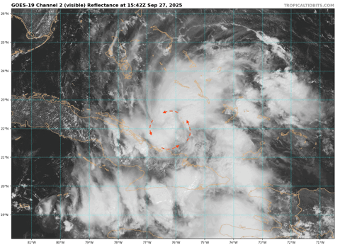
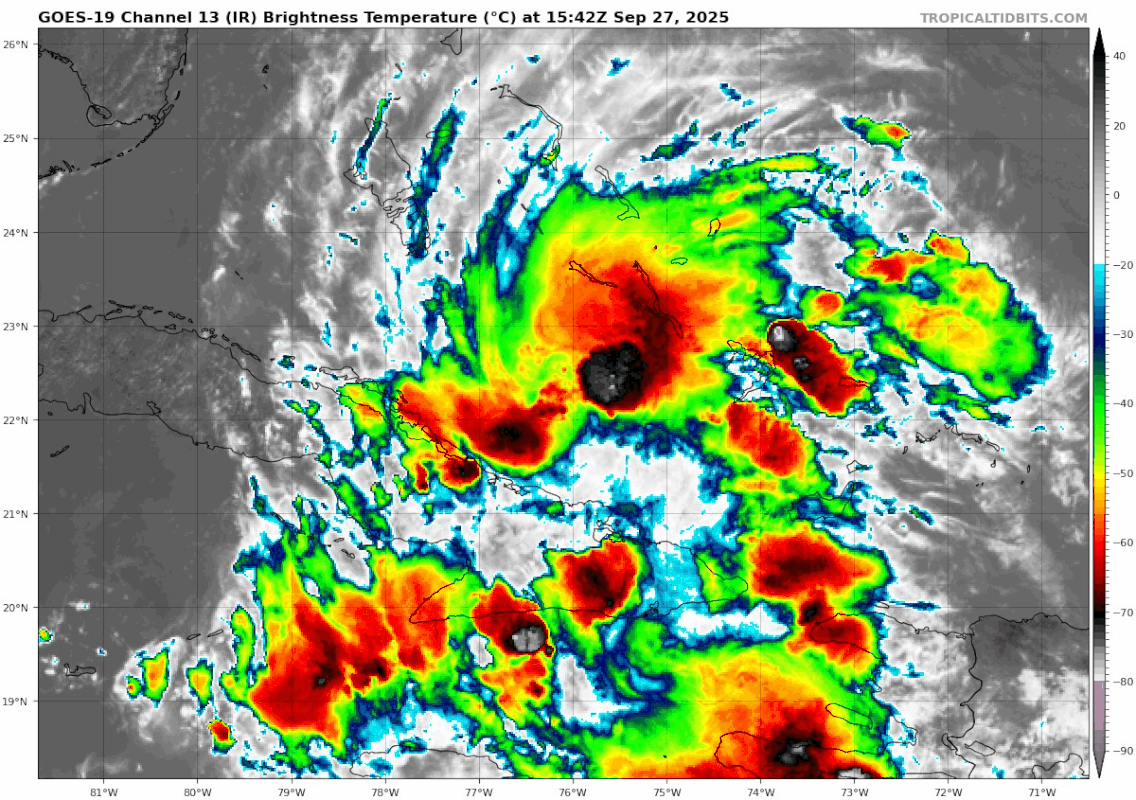
Getting those fanning cirrus clouds suggesting a small anticyclone building over TD9. Looks like she's starting to organize today.
3 likes

Re: NATL: NINE - Tropical Depression - Discussion
Regardless of landfall, extremely dangerous rainfall totals seem to always be a threat for the Carolina coasts in every model run. Some models showing more than we got in 2018 (24in). That washes away highways and left homes here under water.
I'm growing more concerned by the minute.
I'm growing more concerned by the minute.
3 likes
-
tolakram
- Admin

- Posts: 20186
- Age: 62
- Joined: Sun Aug 27, 2006 8:23 pm
- Location: Florence, KY (name is Mark)
Re: NATL: NINE - Tropical Depression - Discussion
I think recon finds a tropical storm, looks to be steadily organizing. As someone mentioned above the upper levels look favorable as well.

4 likes
M a r k
- - - - -
Join us in chat: Storm2K Chatroom Invite. Android and IOS apps also available.
The posts in this forum are NOT official forecasts and should not be used as such. Posts are NOT endorsed by any professional institution or STORM2K.org. For official information and forecasts, please refer to NHC and NWS products.
Re: NATL: NINE - Tropical Depression - Discussion
tolakram wrote:I think recon finds a tropical storm, looks to be steadily organizing. As someone mentioned above the upper levels look favorable as well.
https://i.imgur.com/GqvNws7.gif
Deterministic bifurcation, yeah that was the word we were looking for
0 likes
Re: NATL: NINE - Tropical Depression - Discussion
Nimbus wrote:tolakram wrote:I think recon finds a tropical storm, looks to be steadily organizing. As someone mentioned above the upper levels look favorable as well.
https://i.imgur.com/GqvNws7.gif
Deterministic bifurcation, yeah that was the word we were looking for
0 likes
Re: NATL: NINE - Tropical Depression - Discussion
Seeing a high helicity hot tower quickly fire and then move east to west.
Good sign its picking up steam.
Good sign its picking up steam.
1 likes
-
REDHurricane

- Category 1

- Posts: 438
- Age: 28
- Joined: Sun Jul 03, 2022 2:36 pm
- Location: Northeast Pacific Ocean
-
eastcoastFL

- Category 5
- Posts: 3996
- Age: 44
- Joined: Thu Apr 12, 2007 12:29 pm
- Location: Palm City, FL
Re: NATL: NINE - Tropical Depression - Discussion
is there a tornado threat for east Central Florida from this system?GCANE wrote:Seeing a high helicity hot tower quickly fire and then move east to west.
Good sign its picking up steam.
0 likes
Personal Forecast Disclaimer:
The posts in this forum are NOT official forecast and should not be used as such. They are just the opinion of the poster and may or may not be backed by sound meteorological data. They are NOT endorsed by any professional institution or storm2k.org. For official information, please refer to the NHC and NWS products.
The posts in this forum are NOT official forecast and should not be used as such. They are just the opinion of the poster and may or may not be backed by sound meteorological data. They are NOT endorsed by any professional institution or storm2k.org. For official information, please refer to the NHC and NWS products.

Re: NATL: NINE - Tropical Depression - Discussion
If the gulf trough pulls out or weakens more, would that let the high ridge build west- pushing storm west more?
0 likes
-
skillz305
- Category 1
- Posts: 312
- Joined: Sat Sep 08, 2018 11:10 am
- Location: Miami, Florida --> Vero Beach, Florida
Re: NATL: NINE - Tropical Depression - Discussion
2pm NHC
22.0 N 76.5 W
No northern movement since 11am
22.0 N 76.5 W
No northern movement since 11am
1 likes
 Hurricanes: Andrew 1992 - Irene 1999 - Frances 2004 - Jeanne 2004 - Katrina 2005 - Wilma 2005 - Matthew 2016 - Irma 2017 - Ian 2022 - Nicole 2022 - Milton 2024
Re: NATL: NINE - Tropical Depression - Discussion
skillz305 wrote:2pm NHC
22.0 N 76.5 W
No northern movement since 11am
The latest hot tower is basically right on top of the NHC position.
0 likes
TC naming lists: retirements and intensity
Most aggressive Advisory #1's in North Atlantic (cr. kevin for starting the list)
Most aggressive Advisory #1's in North Atlantic (cr. kevin for starting the list)
-
wxman57

- Moderator-Pro Met

- Posts: 23175
- Age: 68
- Joined: Sat Jun 21, 2003 8:06 pm
- Location: Houston, TX (southwest)
Re: NATL: NINE - Tropical Depression - Discussion
eastcoastFL wrote:is there a tornado threat for east Central Florida from this system?GCANE wrote:Seeing a high helicity hot tower quickly fire and then move east to west.
Good sign its picking up steam.
Very unlikely. First of all dry air will be flowing across Florida through Monday. Second, tornadoes almost always form in the outer bands in the right-front quadrant of a storm.
1 likes
Re: NATL: NINE - Tropical Depression - Discussion
Afternoon popups already firing across Florida.
Will reduce shear ahead of the storm.
Will reduce shear ahead of the storm.
2 likes

Re: NATL: NINE - Tropical Depression - Discussion
GCANE wrote:Afternoon popups already firing across Florida.
Will reduce shear ahead of the storm.
Gcane do you see 9 moving more west towards S Florida than the forecast shows?
1 likes
Who is online
Users browsing this forum: No registered users and 40 guests