NATL: HUMBERTO - Remnants - Discussion

Moderator: S2k Moderators

Message
Author
User avatar
Ubuntwo
Category 5
Category 5
Posts: 1429
Age: 31
Joined: Thu Oct 05, 2017 10:41 pm

Re: NATL: HUMBERTO - Hurricane - Discussion

#261 Postby Ubuntwo » Sat Sep 27, 2025 12:25 pm

CrazyC83 wrote:What is the eye temperature? That can help provide a gauge. Dorian had a similar appearance but an incredible eye temperature.

I'd have to guess we have a cat 5 right now. I'd go 140 kt / 924 mb.

20.8C from GOES. A sentinel pass at 14z measured 24.3C
5 likes   
Kendall -> SLO -> PBC

Memorable Storms: Katrina (for its Florida landfall...) Wilma Matthew Irma

tolakram
Admin
Admin
Posts: 20118
Age: 62
Joined: Sun Aug 27, 2006 8:23 pm
Location: Florence, KY (name is Mark)

Re: NATL: HUMBERTO - Hurricane - Discussion

#262 Postby tolakram » Sat Sep 27, 2025 12:26 pm

Beautiful storm, classic buzzsaw

Image
4 likes   
M a r k
- - - - -
Join us in chat: Storm2K Chatroom Invite. Android and IOS apps also available.

The posts in this forum are NOT official forecasts and should not be used as such. Posts are NOT endorsed by any professional institution or STORM2K.org. For official information and forecasts, please refer to NHC and NWS products.

User avatar
Travorum
Category 2
Category 2
Posts: 536
Joined: Tue Sep 05, 2023 9:36 am
Location: Dunedin, FL

Re: NATL: HUMBERTO - Hurricane - Discussion

#263 Postby Travorum » Sat Sep 27, 2025 12:26 pm

CrazyC83 wrote:What is the eye temperature? That can help provide a gauge. Dorian had a similar appearance but an incredible eye temperature.

I'd have to guess we have a cat 5 right now. I'd go 140 kt / 924 mb.


From goes imagery on cyclonicwx the eye temp has been hovering around 20/21C for the past several hours.
0 likes   

zzzh
Category 4
Category 4
Posts: 938
Joined: Thu Sep 02, 2021 1:13 pm

Re: NATL: HUMBERTO - Hurricane - Discussion

#264 Postby zzzh » Sat Sep 27, 2025 12:27 pm

CrazyC83 wrote:What is the eye temperature? That can help provide a gauge. Dorian had a similar appearance but an incredible eye temperature.

I'd have to guess we have a cat 5 right now. I'd go 140 kt / 924 mb.

Sentinel 3B captured an eye temp of 24.3 at 14:00z (note that the angle was not the best).
1 likes   

User avatar
weeniepatrol
Category 5
Category 5
Posts: 1318
Joined: Sat Aug 22, 2020 5:30 pm
Location: WA State

Re: NATL: HUMBERTO - Hurricane - Discussion

#265 Postby weeniepatrol » Sat Sep 27, 2025 12:42 pm

With an eye temperature over 20 C, 125 kt is a ridiculous estimate. This is not critique of NHC but rather is critique of Dvorak. We've seen countless examples that it underrates major hurricanes. Too much emphasis on cloud top temperatures. The tropopause in the Atlantic is shallower. You're not going to nor are supposed to GET colder cloud tops. We are not the western Pacific. Eye temperature seems to be much more important. I'm not sure there's ever been an instance of a hurricane with a 20 C eye that wasn't stronger than 125 kt before? lol

Laura 2020 is the weakest 20 C eye hurricane I can think of and it was still 130 kt
4 likes   

User avatar
aspen
Category 5
Category 5
Posts: 8917
Joined: Sat Oct 12, 2019 7:10 pm
Location: Connecticut, USA

Re: NATL: HUMBERTO - Hurricane - Discussion

#266 Postby aspen » Sat Sep 27, 2025 12:49 pm

weeniepatrol wrote:With an eye temperature over 20 C, 125 kt is a ridiculous estimate. This is not critique of NHC but rather is critique of Dvorak. We've seen countless examples that it underrates major hurricanes. Too much emphasis on cloud top temperatures. The tropopause in the Atlantic is shallower. You're not going to nor are supposed to GET colder cloud tops. We are not the western Pacific. Eye temperature seems to be much more important. I'm not sure there's ever been an instance of a hurricane with a 20 C eye that wasn't stronger than 125 kt before? lol

Laura 2020 is the weakest 20 C eye hurricane I can think of and it was still 130 kt

Agreed, Dvorak absolutely needs to start giving more weight to eye temperature. Eye shape and overall CDO structure need to be given attention in the model too. They’re something us human forecasters can easily pick out as indicative of an upper-echelon TC, but I’m not aware of how much they’re factored into ADT. Something like Humberto with a sharply defined >20C eye within a near-circular W-ring should be given more weight in ADT than deeper but less even convection around a less symmetrical eye like Lorenzo.

This isn’t just an Atlantic problem. The Pacific has had several offenders since 2020, such as Douglas, Darby, Dora, Gilma, and others. Gilma especially was really bad, with all three peaks being 10-20 kt underestimated due to bad luck with ADT.
3 likes   
Irene '11 Sandy '12 Hermine '16 5/15/2018 Derecho Fay '20 Isaias '20 Elsa '21 Henri '21 Ida '21

I am only a meteorology enthusiast who knows a decent amount about tropical cyclones. Look to the professional mets, the NHC, or your local weather office for the best information.

bob rulz
Category 5
Category 5
Posts: 1709
Age: 35
Joined: Sat Jan 28, 2006 7:30 pm
Location: Salt Lake City, Utah

Re: NATL: HUMBERTO - Hurricane - Discussion

#267 Postby bob rulz » Sat Sep 27, 2025 12:49 pm

So is there just no chance of getting recon into this storm?

I know there has been recons into multiple storms at the same time in the past...has the budget for recon diminished so much they can't spare 1 plane for Humberto?
0 likes   

MarioProtVI
Category 5
Category 5
Posts: 1002
Age: 24
Joined: Sun Sep 29, 2019 7:33 pm
Location: New Jersey

Re: NATL: HUMBERTO - Hurricane - Discussion

#268 Postby MarioProtVI » Sat Sep 27, 2025 12:51 pm

I’m not expecting them to go C5 operationally nor in TCR (see Sam and Jose), mostly because it’s a guarantee ADT will trip up and remain T6.5 while TAFB either is 6.8 or 7.0, with a split down the middle for a 135 kt estimate.
0 likes   

User avatar
weeniepatrol
Category 5
Category 5
Posts: 1318
Joined: Sat Aug 22, 2020 5:30 pm
Location: WA State

Re: NATL: HUMBERTO - Hurricane - Discussion

#269 Postby weeniepatrol » Sat Sep 27, 2025 12:53 pm

Image


bob rulz wrote:So is there just no chance of getting recon into this storm?

I know there has been recons into multiple storms at the same time in the past...has the budget for recon diminished so much they can't spare 1 plane for Humberto?


Recon is scheduled for tomorrow evening.
3 likes   

User avatar
Teban54
Category 5
Category 5
Posts: 3523
Joined: Sat May 19, 2018 1:19 pm

Re: NATL: HUMBERTO - Hurricane - Discussion

#270 Postby Teban54 » Sat Sep 27, 2025 12:53 pm

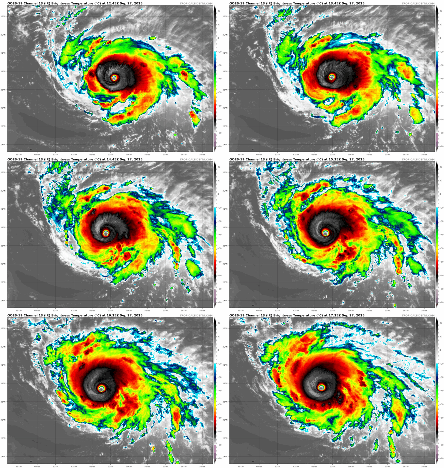
The last few frames seem to show some continued improvement in CDO, even if minor.

Image
2 likes   

User avatar
weeniepatrol
Category 5
Category 5
Posts: 1318
Joined: Sat Aug 22, 2020 5:30 pm
Location: WA State

Re: NATL: HUMBERTO - Hurricane - Discussion

#271 Postby weeniepatrol » Sat Sep 27, 2025 12:53 pm

Image
5 likes   

User avatar
Iceresistance
Category 5
Category 5
Posts: 9312
Age: 22
Joined: Sat Oct 10, 2020 9:45 am
Location: Tecumseh, OK/Norman, OK

Re: NATL: HUMBERTO - Hurricane - Discussion

#272 Postby Iceresistance » Sat Sep 27, 2025 12:55 pm


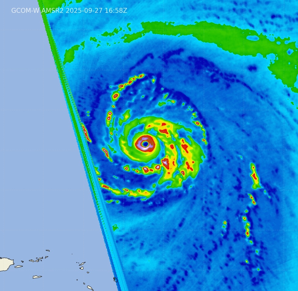
There is also this, but my goodness what a core :eek:
Image
https://s14.gifyu.com/images/bw3zB.png
5 likes   
Bill 2015 & Beta 2020

Winter 2020-2021 :cold:

All observations are in Tecumseh, OK unless otherwise noted.

Winter posts are focused mainly for Oklahoma & Texas.

Take any of my forecasts with a grain of salt, refer to the NWS, SPC, and NHC for official information

Never say Never with weather! Because ANYTHING is possible!

User avatar
aspen
Category 5
Category 5
Posts: 8917
Joined: Sat Oct 12, 2019 7:10 pm
Location: Connecticut, USA

Re: NATL: HUMBERTO - Hurricane - Discussion

#273 Postby aspen » Sat Sep 27, 2025 12:57 pm

bob rulz wrote:So is there just no chance of getting recon into this storm?

I know there has been recons into multiple storms at the same time in the past...has the budget for recon diminished so much they can't spare 1 plane for Humberto?

Recon is scheduled…but not until Monday. So we won’t get a plane in until long after Humberto’s likely Cat 5 peak.

I’m not sure how much of the lack of Humberto recon has to do with budget issues, or the NHC trying to figure out a recon schedule for the highly uncertain TD9. Either way, I agree that it seems feasible for them to have been able to send something into Humberto without interfering with TD9 coverage.
1 likes   
Irene '11 Sandy '12 Hermine '16 5/15/2018 Derecho Fay '20 Isaias '20 Elsa '21 Henri '21 Ida '21

I am only a meteorology enthusiast who knows a decent amount about tropical cyclones. Look to the professional mets, the NHC, or your local weather office for the best information.

User avatar
cycloneye
Admin
Admin
Posts: 147759
Age: 69
Joined: Thu Oct 10, 2002 10:54 am
Location: San Juan, Puerto Rico

Re: NATL: HUMBERTO - Hurricane - Discussion

#274 Postby cycloneye » Sat Sep 27, 2025 1:03 pm

Breaking news= Two planes will go to Humberto on Sunday afternoon/evening and on Monday morning

Hurricane2022, there is the answer to your question.

HURRICANE HUMBERTO

FLIGHT ONE - TEAL 77 FLIGHT TWO - TEAL 78
A. 29/0000Z A. 29/1200Z
B. AFXXX 0108A HUMBERTO B. AFXXX 0208A HUMBERTO
C. 28/2100Z C. 29/0915Z
D. 25.5N 65.3W D. 27.1N 66.8W
E. 28/2330Z TO 29/0300Z E. 29/1130Z TO 29/1500Z
F. SFC TO 15,000 FT F. SFC TO 15,000 FT
G. FIX G. FIX
H. WRA ACTIVATION H. WRA ACTIVATION
2 likes   
Visit the Caribbean-Central America Weather Thread where you can find at first post web cams,radars
and observations from Caribbean basin members Click Here

User avatar
StormWeather
Category 1
Category 1
Posts: 442
Joined: Wed Jun 05, 2024 2:34 pm

Re: NATL: HUMBERTO - Hurricane - Discussion

#275 Postby StormWeather » Sat Sep 27, 2025 1:05 pm

cycloneye wrote:Breaking news= Two planes will go to Humberto on Sunday afternoon/evening and on Monday morning

Hurricane2022, there is the answer to your question.

HURRICANE HUMBERTO

FLIGHT ONE - TEAL 77 FLIGHT TWO - TEAL 78
A. 29/0000Z A. 29/1200Z
B. AFXXX 0108A HUMBERTO B. AFXXX 0208A HUMBERTO
C. 28/2100Z C. 29/0915Z
D. 25.5N 65.3W D. 27.1N 66.8W
E. 28/2330Z TO 29/0300Z E. 29/1130Z TO 29/1500Z
F. SFC TO 15,000 FT F. SFC TO 15,000 FT
G. FIX G. FIX
H. WRA ACTIVATION H. WRA ACTIVATION

Thank the lord!! I didn’t want another Cat 5 debate out of this
0 likes   
Just an average cyclone tracker

The posts in this forum are NOT official forecasts and should not be used as such. They are just the opinion of the poster and may or may not be backed by sound meteorological data. They are NOT endorsed by any professional institution or storm2k.org. For official information, please refer to the NHC and NWS products

User avatar
Kingarabian
S2K Supporter
S2K Supporter
Posts: 16261
Joined: Sat Aug 08, 2009 3:06 am
Location: Honolulu, Hawaii

Re: NATL: HUMBERTO - Hurricane - Discussion

#276 Postby Kingarabian » Sat Sep 27, 2025 1:11 pm

weeniepatrol wrote:https://i.imgur.com/1UHyuPz.png


bob rulz wrote:So is there just no chance of getting recon into this storm?

I know there has been recons into multiple storms at the same time in the past...has the budget for recon diminished so much they can't spare 1 plane for Humberto?


Recon is scheduled for tomorrow evening.


Would go 140kts with that MW presentation. That's extremely impressive.

Humberto seems to be stuck at T6.5 and inner dynamics could stop this from reaching a T7.0.
2 likes   
RIP Kobe Bryant

bob rulz
Category 5
Category 5
Posts: 1709
Age: 35
Joined: Sat Jan 28, 2006 7:30 pm
Location: Salt Lake City, Utah

Re: NATL: HUMBERTO - Hurricane - Discussion

#277 Postby bob rulz » Sat Sep 27, 2025 1:16 pm

Well I guess there's my answer lol
0 likes   

User avatar
Hurricane2022
Category 5
Category 5
Posts: 1750
Joined: Tue Aug 23, 2022 11:38 pm
Location: Araçatuba, Brazil

Re: NATL: HUMBERTO - Hurricane - Discussion

#278 Postby Hurricane2022 » Sat Sep 27, 2025 1:17 pm

cycloneye wrote:Breaking news= Two planes will go to Humberto on Sunday afternoon/evening and on Monday morning

Hurricane2022, there is the answer to your question.

HURRICANE HUMBERTO

FLIGHT ONE - TEAL 77 FLIGHT TWO - TEAL 78
A. 29/0000Z A. 29/1200Z
B. AFXXX 0108A HUMBERTO B. AFXXX 0208A HUMBERTO
C. 28/2100Z C. 29/0915Z
D. 25.5N 65.3W D. 27.1N 66.8W
E. 28/2330Z TO 29/0300Z E. 29/1130Z TO 29/1500Z
F. SFC TO 15,000 FT F. SFC TO 15,000 FT
G. FIX G. FIX
H. WRA ACTIVATION H. WRA ACTIVATION

I was looking for a mission THIS afternoon/evening :cry: but anyway it's better than nothing :wink:
1 likes   
Sorry for the bad English sometimes...!
For reliable and detailed information for any meteorological phenomenon, please consult the National Hurricane Center, Joint Typhoon Warning Center , or your local Meteo Center.

--------

Una cvm Christo, pro Christo, et in Christo. Sit nomen Domini benedictvm.

User avatar
cycloneye
Admin
Admin
Posts: 147759
Age: 69
Joined: Thu Oct 10, 2002 10:54 am
Location: San Juan, Puerto Rico

Re: NATL: HUMBERTO - Hurricane - Discussion

#279 Postby cycloneye » Sat Sep 27, 2025 1:26 pm

AL, 08, 2025092718, , BEST, 0, 228N, 608W, 135, 926, HU
0 likes   
Visit the Caribbean-Central America Weather Thread where you can find at first post web cams,radars
and observations from Caribbean basin members Click Here

Pelicane
Tropical Storm
Tropical Storm
Posts: 176
Joined: Tue Sep 13, 2022 1:52 pm
Location: Lafayette, Louisiana

Re: NATL: HUMBERTO - Hurricane - Discussion

#280 Postby Pelicane » Sat Sep 27, 2025 1:27 pm

CDO keeps getting cooler, hard to imagine this isn't at or near C5 atm.
1 likes   


Return to “2025”

Who is online

Users browsing this forum: No registered users and 42 guests