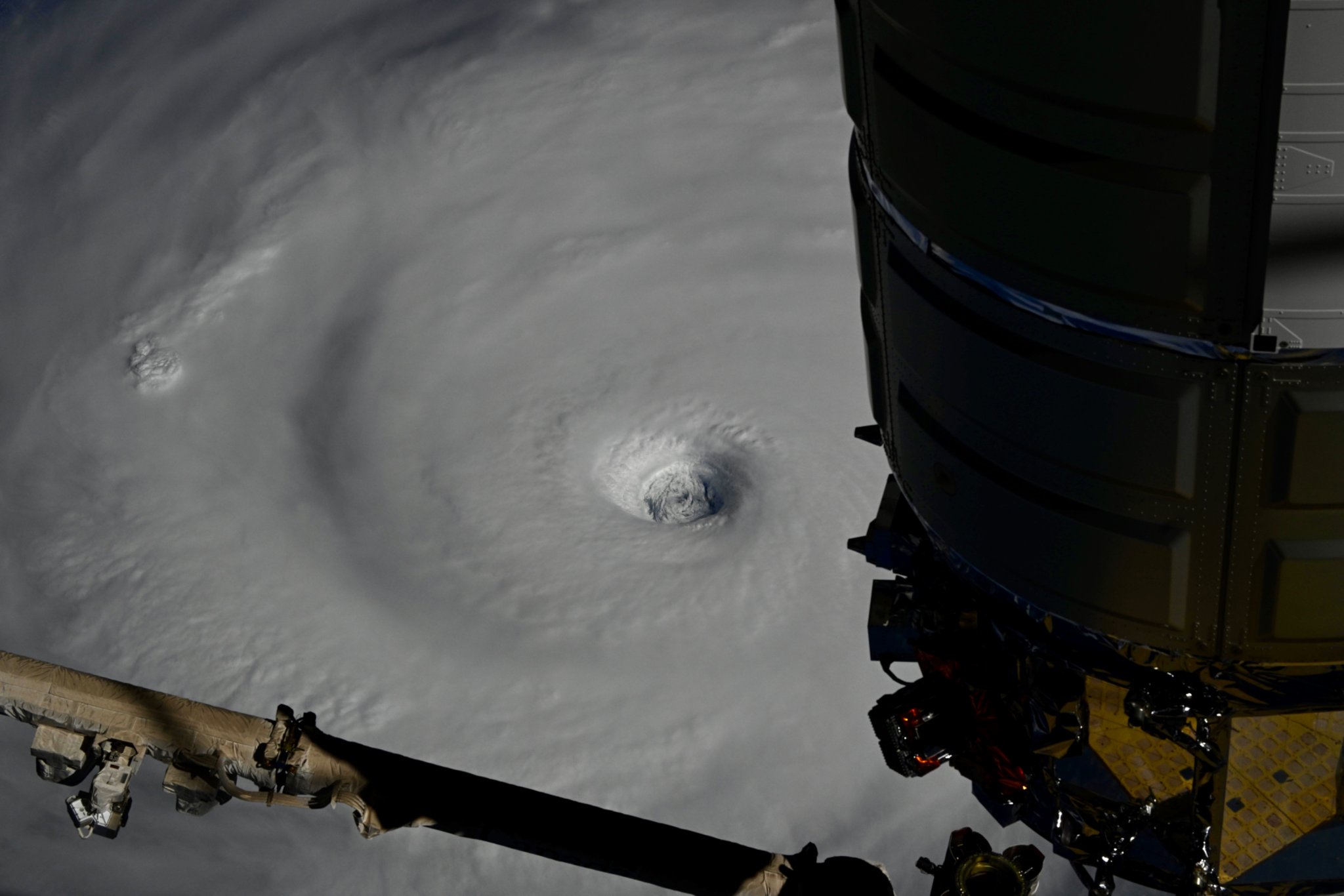
https://x.com/Astro_Kimiya/status/1969631317005402413
WPAC: NEOGURI - Post-Tropical
Moderator: S2k Moderators
- doomhaMwx
- Category 5
- Posts: 2467
- Age: 26
- Joined: Tue Apr 18, 2017 4:01 am
- Location: Baguio/Benguet, Philippines
- Contact:
Re: WPAC: NEOGURI - Typhoon
2 likes
- cycloneye
- Admin
- Posts: 147496
- Age: 69
- Joined: Thu Oct 10, 2002 10:54 am
- Location: San Juan, Puerto Rico
Re: WPAC: NEOGURI - Typhoon

0 likes
Visit the Caribbean-Central America Weather Thread where you can find at first post web cams,radars
and observations from Caribbean basin members Click Here
- Hurricane2022
- Category 5
- Posts: 1734
- Joined: Tue Aug 23, 2022 11:38 pm
- Location: Araçatuba, Brazil
Re: WPAC: NEOGURI - Typhoon
This was indeed a C5 at peak. (Another) huge L from JTWC.
https://x.com/xiaoqianWX/status/1969643789246489074
2 likes
Sorry for the bad English sometimes...!
For reliable and detailed information for any meteorological phenomenon, please consult the National Hurricane Center, Joint Typhoon Warning Center , or your local Meteo Center.
--------
Una cvm Christo, pro Christo, et in Christo. Sit nomen Domini benedictvm.
For reliable and detailed information for any meteorological phenomenon, please consult the National Hurricane Center, Joint Typhoon Warning Center , or your local Meteo Center.
--------
Una cvm Christo, pro Christo, et in Christo. Sit nomen Domini benedictvm.
- cycloneye
- Admin
- Posts: 147496
- Age: 69
- Joined: Thu Oct 10, 2002 10:54 am
- Location: San Juan, Puerto Rico
Re: WPAC: NEOGURI - Typhoon
25W NEOGURI 250921 1200 28.5N 151.4E WPAC 120 939
0 likes
Visit the Caribbean-Central America Weather Thread where you can find at first post web cams,radars
and observations from Caribbean basin members Click Here
- cycloneye
- Admin
- Posts: 147496
- Age: 69
- Joined: Thu Oct 10, 2002 10:54 am
- Location: San Juan, Puerto Rico
Re: WPAC: NEOGURI - Typhoon
All the headlines and sure justified are for Ragasa, but let's not forget Neoguri that has put a show of spectacular photogenic images.


5 likes
Visit the Caribbean-Central America Weather Thread where you can find at first post web cams,radars
and observations from Caribbean basin members Click Here
- cycloneye
- Admin
- Posts: 147496
- Age: 69
- Joined: Thu Oct 10, 2002 10:54 am
- Location: San Juan, Puerto Rico
Re: WPAC: NEOGURI - Typhoon
25W NEOGURI 250921 1800 29.3N 150.9E WPAC 110 947
0 likes
Visit the Caribbean-Central America Weather Thread where you can find at first post web cams,radars
and observations from Caribbean basin members Click Here
-
- Category 5
- Posts: 9708
- Age: 39
- Joined: Thu Jul 06, 2017 1:51 am
- cycloneye
- Admin
- Posts: 147496
- Age: 69
- Joined: Thu Oct 10, 2002 10:54 am
- Location: San Juan, Puerto Rico
Re: WPAC: NEOGURI - Typhoon
The sun rises over Neoguri and still looks great.


1 likes
Visit the Caribbean-Central America Weather Thread where you can find at first post web cams,radars
and observations from Caribbean basin members Click Here
- cycloneye
- Admin
- Posts: 147496
- Age: 69
- Joined: Thu Oct 10, 2002 10:54 am
- Location: San Juan, Puerto Rico
Re: WPAC: NEOGURI - Typhoon
So far, Neoguri has 10.5 of ACE and looks like it will be around for a few more days to get some more.
0 likes
Visit the Caribbean-Central America Weather Thread where you can find at first post web cams,radars
and observations from Caribbean basin members Click Here
- cycloneye
- Admin
- Posts: 147496
- Age: 69
- Joined: Thu Oct 10, 2002 10:54 am
- Location: San Juan, Puerto Rico
Re: WPAC: NEOGURI - Tropical Storm
It has been a long journey for Neoguri that has shown amazing images when it was at peak but is comming to an end soon.


1 likes
Visit the Caribbean-Central America Weather Thread where you can find at first post web cams,radars
and observations from Caribbean basin members Click Here
- cycloneye
- Admin
- Posts: 147496
- Age: 69
- Joined: Thu Oct 10, 2002 10:54 am
- Location: San Juan, Puerto Rico
Re: WPAC: NEOGURI - Typhoon
SATELLITE ANALYSIS, INITIAL POSITION AND INTENSITY DISCUSSION:
REANALYSIS OF WINDSPEED DATA (SMAP, SMOS AND SAR IMAGERY) FROM
240600-1200Z INDICATES THE SYSTEM LIKELY REINTENSIFIED TO MINIMUM
TYPHOON (TY) STRENGTH. ADDITIONALLY, A 241020Z ASCAT-C IMAGE
REVEALED A SWATH OF 60 KNOT WINDS OVER THE EASTERN QUADRANT
SUGGESTING TYPHOON STRENGTH WINDS. ALTHOUGH THE SYSTEM'S CONVECTIVE
APPEARANCE IS NOT OVERLY IMPRESSIVE, ANIMATED ENHANCED INFRARED (EIR)
SATELLITE IMAGERY DEPICTS DEEP CONVECTIVE BANDING WRAPPING AROUND A
RAGGED, WEAK EYE, WHICH SUPPORTS THE INITIAL POSITION WITH HIGH
CONFIDENCE. THE SYSTEM HAS MAINTAINED EXCELLENT POLEWARD OUTFLOW INTO
A SHARP UPPER-LEVEL TROUGH TO THE NORTH, WITH LOW VERTICAL WIND SHEAR
AND WARM SST VALUES. THE INITIAL INTENSITY OF 65 KTS IS ASSESSED WITH
MEDIUM CONFIDENCE BASED ON THE RECENT WINDSPEED DATA CONSISTENT WITH
THE WEAK EYE FEATURE.
0 likes
Visit the Caribbean-Central America Weather Thread where you can find at first post web cams,radars
and observations from Caribbean basin members Click Here
- cycloneye
- Admin
- Posts: 147496
- Age: 69
- Joined: Thu Oct 10, 2002 10:54 am
- Location: San Juan, Puerto Rico
Re: WPAC: NEOGURI - Tropical Storm
Still hanging on after more than 10 days and may be a Typhoon once again.


1 likes
Visit the Caribbean-Central America Weather Thread where you can find at first post web cams,radars
and observations from Caribbean basin members Click Here
- StormWeather
- Category 1
- Posts: 436
- Joined: Wed Jun 05, 2024 2:34 pm
Re: WPAC: NEOGURI - Tropical Storm
cycloneye wrote:Still hanging on after more than 10 days and may be a Typhoon once again.
https://i.imgur.com/H4XYmYr.gif
Neoguri outlasted her twin Ragasa and may also outlast Bualoi potentially
3 likes
Just an average cyclone tracker
The posts in this forum are NOT official forecasts and should not be used as such. They are just the opinion of the poster and may or may not be backed by sound meteorological data. They are NOT endorsed by any professional institution or storm2k.org. For official information, please refer to the NHC and NWS products
- cycloneye
- Admin
- Posts: 147496
- Age: 69
- Joined: Thu Oct 10, 2002 10:54 am
- Location: San Juan, Puerto Rico
Re: WPAC: NEOGURI - Tropical Storm
Like the battery ad, keeps going, and going, and going.....
JTWC has it as Typhoon while JMA is at Severe Tropical Storm.


2 likes
Visit the Caribbean-Central America Weather Thread where you can find at first post web cams,radars
and observations from Caribbean basin members Click Here
- StormWeather
- Category 1
- Posts: 436
- Joined: Wed Jun 05, 2024 2:34 pm
Re: WPAC: NEOGURI - Severe Tropical Storm
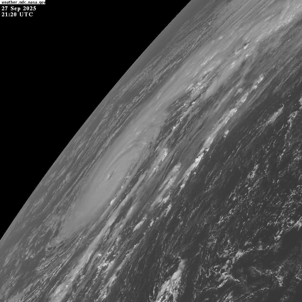
cycloneye wrote:Like the battery ad, keeps going, and going, and going.....JTWC has it as Typhoon while JMA is at Severe Tropical Storm.
https://i.imgur.com/2Dtzg0B.gif
Definitely a resilient storm, I’ll give it that
3 likes
Just an average cyclone tracker
The posts in this forum are NOT official forecasts and should not be used as such. They are just the opinion of the poster and may or may not be backed by sound meteorological data. They are NOT endorsed by any professional institution or storm2k.org. For official information, please refer to the NHC and NWS products
- Hurricane2022
- Category 5
- Posts: 1734
- Joined: Tue Aug 23, 2022 11:38 pm
- Location: Araçatuba, Brazil
Re: WPAC: NEOGURI - Severe Tropical Storm
The last hurrah!


4 likes
Sorry for the bad English sometimes...!
For reliable and detailed information for any meteorological phenomenon, please consult the National Hurricane Center, Joint Typhoon Warning Center , or your local Meteo Center.
--------
Una cvm Christo, pro Christo, et in Christo. Sit nomen Domini benedictvm.
For reliable and detailed information for any meteorological phenomenon, please consult the National Hurricane Center, Joint Typhoon Warning Center , or your local Meteo Center.
--------
Una cvm Christo, pro Christo, et in Christo. Sit nomen Domini benedictvm.
- cycloneye
- Admin
- Posts: 147496
- Age: 69
- Joined: Thu Oct 10, 2002 10:54 am
- Location: San Juan, Puerto Rico
Re: WPAC: NEOGURI - Typhoon
JMA upgrades to Typhoon. Yes, the last hurrah, gas etc.
It was overshadowed by Ragasa but this one was photogenic at it's peak.

T2519(Neoguri)
Issued at 2025/09/27 19:00 UTC
Analysis at 09/27 18 UTC
Grade TY
Scale -
Intensity -
Center position N33°10′ (33.2°)
E160°25′ (160.4°)
Direction and speed of movement ENE 30 km/h (17 kt)
Central pressure 960 hPa
Maximum sustained wind speed near center 40 m/s (80 kt)
Maximum wind gust speed 60 m/s (115 kt)
Radius of 50-kt wind area 110 km (60 NM)
Radius of 30-kt wind area SE330 km (180 NM)
NW220 km (120 NM)
0 likes
Visit the Caribbean-Central America Weather Thread where you can find at first post web cams,radars
and observations from Caribbean basin members Click Here
- cycloneye
- Admin
- Posts: 147496
- Age: 69
- Joined: Thu Oct 10, 2002 10:54 am
- Location: San Juan, Puerto Rico
Re: WPAC: NEOGURI - Typhoon

0 likes
Visit the Caribbean-Central America Weather Thread where you can find at first post web cams,radars
and observations from Caribbean basin members Click Here
- Hurricane2022
- Category 5
- Posts: 1734
- Joined: Tue Aug 23, 2022 11:38 pm
- Location: Araçatuba, Brazil
Re: WPAC: NEOGURI - Typhoon
Still intensifying


2 likes
Sorry for the bad English sometimes...!
For reliable and detailed information for any meteorological phenomenon, please consult the National Hurricane Center, Joint Typhoon Warning Center , or your local Meteo Center.
--------
Una cvm Christo, pro Christo, et in Christo. Sit nomen Domini benedictvm.
For reliable and detailed information for any meteorological phenomenon, please consult the National Hurricane Center, Joint Typhoon Warning Center , or your local Meteo Center.
--------
Una cvm Christo, pro Christo, et in Christo. Sit nomen Domini benedictvm.
- mrbagyo
- Category 5
- Posts: 3811
- Age: 33
- Joined: Thu Apr 12, 2012 9:18 am
- Location: 14.13N 120.98E
- Contact:
Re: WPAC: NEOGURI - Typhoon
eye is full cleared, satellite viewing angle is just not optimal


2 likes
The posts in this forum are NOT official forecast and should not be used as such. They are just the opinion of the poster and may or may not be backed by sound meteorological data. They are NOT endorsed by any professional institution or storm2k.org. For official information, please refer to RSMC, NHC and NWS products.
Who is online
Users browsing this forum: No registered users and 45 guests