EP, 14, 2025092600, , BEST, 0, 163N, 1187W, 80, 980, HU
EPAC: NARDA - Remnants - Discussion
Moderator: S2k Moderators
-
cycloneye

- Admin

- Posts: 149275
- Age: 69
- Joined: Thu Oct 10, 2002 10:54 am
- Location: San Juan, Puerto Rico
Re: EPAC: NARDA - Hurricane - Discussion
Mantains at 80kts.
0 likes
Visit the Caribbean-Central America Weather Thread where you can find at first post web cams,radars
and observations from Caribbean basin members Click Here
and observations from Caribbean basin members Click Here
-
Kingarabian

- S2K Supporter

- Posts: 16348
- Joined: Sat Aug 08, 2009 3:06 am
- Location: Honolulu, Hawaii
Re: EPAC: NARDA - Hurricane - Discussion
Deep CDO forming. LLC is still NE of the CDO. Could briefly attain a CCC scene type which could cut the time it has to restrengthen. But if it remains CDO dominant this can RI into a MH once again.
0 likes
RIP Kobe Bryant
-
Kingarabian
- S2K Supporter
- Posts: 16348
- Joined: Sat Aug 08, 2009 3:06 am
- Location: Honolulu, Hawaii
-
Kingarabian
- S2K Supporter
- Posts: 16348
- Joined: Sat Aug 08, 2009 3:06 am
- Location: Honolulu, Hawaii
Re: EPAC: NARDA - Hurricane - Discussion
Dual outflow channels are set up. Let's see if it will drop the ball or not.
0 likes
RIP Kobe Bryant
-
Sciencerocks
- Category 5

- Posts: 10181
- Age: 40
- Joined: Thu Jul 06, 2017 1:51 am

-
cycloneye
- Admin
- Posts: 149275
- Age: 69
- Joined: Thu Oct 10, 2002 10:54 am
- Location: San Juan, Puerto Rico
Re: EPAC: NARDA - Hurricane - Discussion
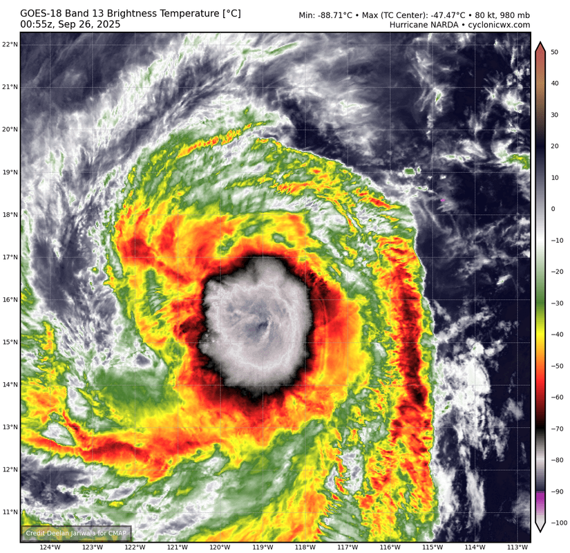
BULLETIN
Hurricane Narda Advisory Number 18
NWS National Hurricane Center Miami FL EP142025
800 PM PDT Thu Sep 25 2025
...NARDA HOLDING STEADY WITH SOME STRENGTHENING POSSIBLE THROUGH
FRIDAY...
SUMMARY OF 800 PM PDT...0300 UTC...INFORMATION
----------------------------------------------
LOCATION...16.4N 119.4W
ABOUT 765 MI...1230 KM SW OF THE SOUTHERN TIP OF BAJA CALIFORNIA
MAXIMUM SUSTAINED WINDS...90 MPH...150 KM/H
PRESENT MOVEMENT...W OR 280 DEGREES AT 16 MPH...26 KM/H
MINIMUM CENTRAL PRESSURE...980 MB...28.94 INCHES
Hurricane Narda Discussion Number 18
NWS National Hurricane Center Miami FL EP142025
800 PM PDT Thu Sep 25 2025
Narda is holding steady this evening despite moderate northeasterly
vertical wind shear of about 15-20 kt. Satellite imagery shows a
well-defined central dense overcast (CDO) with cloud tops to near
-90 C and a convective band wrapping into the center from the south.
The latest subjective Dvorak Current Intensity estimates are 5.0/90
kt from SAB and 4.5/77 kt from TAFB, while objective estimates from
UW-CIMSS range between 65 and 75 kt. Based on a blend of these data
and the satellite presentation, the initial intensity is held at 80
kt for this advisory.
The initial motion is toward the west near 280/14 kt, steered by a
subtropical ridge to its north. This forward speed is expected to
hold steady through early Saturday. After that time, Narda should
begin to slow down as it turns west-northwestward, then
northwestward, and eventually north-northeastward through the
weekend as a weakness develops in the ridge in response to an
upper-level low over California. Beyond 48 h, the forecast track has
been nudged slightly to the left of the previous advisory and lies
close to the multi-model consensus aids.
Some slight strengthening is still possible during the next 12–24 h
while the shear remains moderate and the system stays over warm sea
surface temperatures in a moist mid- to upper-level environment. By
36–48 h, Narda will be moving over cooler waters and into an
increasingly drier mid-level environment with strengthening
southwesterly shear, which should induce a weakening trend. The
system is forecast to fall below hurricane strength by early Sunday
and become a post-tropical remnant low by day 5. The official
intensity forecast is close to the previous one and remains near the
higher end of the guidance envelope.
FORECAST POSITIONS AND MAX WINDS
INIT 26/0300Z 16.4N 119.4W 80 KT 90 MPH
12H 26/1200Z 16.8N 121.4W 85 KT 100 MPH
24H 27/0000Z 17.3N 123.8W 85 KT 100 MPH
36H 27/1200Z 17.8N 125.8W 80 KT 90 MPH
48H 28/0000Z 18.5N 126.9W 65 KT 75 MPH
60H 28/1200Z 19.6N 127.6W 55 KT 65 MPH
72H 29/0000Z 20.6N 127.7W 45 KT 50 MPH
96H 30/0000Z 21.9N 127.0W 35 KT 40 MPH...POST-TROPICAL
120H 01/0000Z 23.1N 126.2W 30 KT 35 MPH...POST-TROP/REMNT LOW
$$
Forecaster Gibbs (CPHC)
0 likes
Visit the Caribbean-Central America Weather Thread where you can find at first post web cams,radars
and observations from Caribbean basin members Click Here
and observations from Caribbean basin members Click Here
-
cycloneye
- Admin
- Posts: 149275
- Age: 69
- Joined: Thu Oct 10, 2002 10:54 am
- Location: San Juan, Puerto Rico
Re: EPAC: NARDA - Hurricane - Discussion
BULLETIN
Hurricane Narda Advisory Number 19
NWS National Hurricane Center Miami FL EP142025
200 AM PDT Fri Sep 26 2025
...NARDA HOLDING STEADY WITH SLIGHT STRENGTHENING POSSIBLE TODAY...
SUMMARY OF 200 AM PDT...0900 UTC...INFORMATION
----------------------------------------------
LOCATION...16.4N 120.7W
ABOUT 835 MI...1340 KM WSW OF THE SOUTHERN TIP OF BAJA CALIFORNIA
MAXIMUM SUSTAINED WINDS...90 MPH...150 KM/H
PRESENT MOVEMENT...W OR 275 DEGREES AT 15 MPH...24 KM/H
MINIMUM CENTRAL PRESSURE...980 MB...28.94 INCHES
Hurricane Narda Discussion Number 19
NWS National Hurricane Center Miami FL EP142025
200 AM PDT Fri Sep 26 2025
Narda has changed little in organization overnight. A 0213 UTC GMI
microwave pass and a coincident SAR RCM-3 NRCS pass revealed a
symmetric eye about 15 n mi wide embedded within the deep
convection, with intermittent bursts producing cloud tops to near
-90 C near and south of the low-level circulation center. A 0520 UTC
METOP-B ASCAT pass depicted a wind field structure similar to that
shown in recent passes over the past 24 h. The latest subjective
Dvorak Current Intensity estimates from SAB and TAFB are both 4.5/77
kt, while objective estimates from UW-CIMSS are in the 58–72 kt
range. Based on these data and the satellite presentation, the
initial intensity is held at 80 kt for this advisory.
The initial motion is toward the west at 275/13 kt, steered by a
subtropical ridge to its north. This motion is expected to continue
through early Saturday. After that time, Narda should begin to slow
down as it turns west-northwestward, then northwestward, and
eventually north-northeastward through the weekend as a weakness
develops in the ridge in response to an upper-level low over
California. The forecast track is very similar to the previous NHC
advisory and lies close to the multi-model consensus aids.
Some slight strengthening can't be ruled out through the day today
while the moderate shear potentially eases and the system remains
over warm sea surface temperatures and within a moist mid- to
upper-level environment. Over the weekend, Narda will be moving over
cooler waters and into an increasingly drier mid-level environment,
which should induce a weakening trend. The system is forecast to
fall below hurricane strength by early Sunday and become a
post-tropical remnant low by day 4. The official intensity forecast
is close to the previous one and remains near the higher end of the
guidance envelope.
FORECAST POSITIONS AND MAX WINDS
INIT 26/0900Z 16.4N 120.7W 80 KT 90 MPH
12H 26/1800Z 16.8N 122.6W 85 KT 100 MPH
24H 27/0600Z 17.3N 124.7W 80 KT 90 MPH
36H 27/1800Z 17.9N 126.2W 70 KT 80 MPH
48H 28/0600Z 18.8N 127.2W 60 KT 70 MPH
60H 28/1800Z 20.0N 127.3W 50 KT 60 MPH
72H 29/0600Z 20.9N 127.1W 40 KT 45 MPH
96H 30/0600Z 21.8N 126.1W 30 KT 35 MPH...POST-TROP/REMNT LOW
120H 01/0600Z 22.9N 125.8W 25 KT 30 MPH...POST-TROP/REMNT LOW
$$
Forecaster Gibbs (CPHC)
0 likes
Visit the Caribbean-Central America Weather Thread where you can find at first post web cams,radars
and observations from Caribbean basin members Click Here
and observations from Caribbean basin members Click Here
-
cycloneye
- Admin
- Posts: 149275
- Age: 69
- Joined: Thu Oct 10, 2002 10:54 am
- Location: San Juan, Puerto Rico
Re: EPAC: NARDA - Hurricane - Discussion
BULLETIN
Hurricane Narda Advisory Number 20
NWS National Hurricane Center Miami FL EP142025
800 AM PDT Fri Sep 26 2025
...NARDA HOLDING STEADY IN STRENGTH WELL OUT TO SEA...
SUMMARY OF 800 AM PDT...1500 UTC...INFORMATION
----------------------------------------------
LOCATION...16.9N 121.9W
ABOUT 880 MI...1420 KM WSW OF THE SOUTHERN TIP OF BAJA CALIFORNIA
MAXIMUM SUSTAINED WINDS...90 MPH...150 KM/H
PRESENT MOVEMENT...WNW OR 285 DEGREES AT 15 MPH...24 KM/H
MINIMUM CENTRAL PRESSURE...980 MB...28.94 INCHES
Hurricane Narda Discussion Number 20
NWS National Hurricane Center Miami FL EP142025
800 AM PDT Fri Sep 26 2025
There has not been much change with Narda over the past several
hours. The hurricane still has a central dense overcast pattern in
satellite images, but there are some dry slots becoming apparent on
the northwest side. The latest satellite intensity estimates have
generally held steady, and the initial wind speed remains 80 kt
using that data.
Narda is moving west-northwestward at 13 kt over the open Pacific
steered by a subtropical ridge to its north-northwest. This ridge
should keep the hurricane on the same general path for about another
day or so. After that time, a significant slow down and gradual
turn to the north and northeast is forecast as the ridge breaks down
due to a series of troughs to its north. The models are in fair
agreement, and only small changes were made to the previous track
forecast.
The hurricane will likely maintain its strength a little longer,
but weakening should begin on Saturday when Narda is forecast to
cross the 26 C SST isotherm. Progressively cooler water and drier
air should cause the system to fall below hurricane strength this
weekend and decay to a post-tropical cyclone in a few days. The
models are in good agreement, and this forecast is a touch lower
than the previous one, trending toward the latest consensus aids.
FORECAST POSITIONS AND MAX WINDS
INIT 26/1500Z 16.9N 121.9W 80 KT 90 MPH
12H 27/0000Z 17.3N 123.6W 80 KT 90 MPH
24H 27/1200Z 17.9N 125.4W 75 KT 85 MPH
36H 28/0000Z 18.6N 126.6W 65 KT 75 MPH
48H 28/1200Z 19.6N 127.1W 55 KT 65 MPH
60H 29/0000Z 20.7N 127.0W 45 KT 50 MPH
72H 29/1200Z 21.4N 126.7W 35 KT 40 MPH...POST-TROPICAL
96H 30/1200Z 21.9N 126.3W 30 KT 35 MPH...POST-TROP/REMNT LOW
120H 01/1200Z 22.8N 126.0W 25 KT 30 MPH...POST-TROP/REMNT LOW
$$
Forecaster Cangialosi
0 likes
Visit the Caribbean-Central America Weather Thread where you can find at first post web cams,radars
and observations from Caribbean basin members Click Here
and observations from Caribbean basin members Click Here
-
Sciencerocks
- Category 5
- Posts: 10181
- Age: 40
- Joined: Thu Jul 06, 2017 1:51 am


Re: EPAC: NARDA - Hurricane - Discussion
Officially just as intense as Humberto, as of 15z.  This needless to say will not be the case for much longer.
2 likes
-
Sciencerocks
- Category 5
- Posts: 10181
- Age: 40
- Joined: Thu Jul 06, 2017 1:51 am
Re: EPAC: NARDA - Hurricane - Discussion
sasha_B wrote:Officially just as intense as Humberto, as of 15z.
Looks like about 60 knts to me. No eye at all. There is no way in hell that this is 80 knts.
2 likes
Re: EPAC: NARDA - Hurricane - Discussion
Sciencerocks wrote:sasha_B wrote:Officially just as intense as Humberto, as of 15z.
Looks like about 60 knts to me. No eye at all. There is no way in hell that this is 80 knts.
Agreed. And Humberto is probably just a bit stronger than 80 kt/979 hPa. Just found the near-identical intensity estimates, for very much not-identical storms, amusing.
1 likes
-
cycloneye
- Admin
- Posts: 149275
- Age: 69
- Joined: Thu Oct 10, 2002 10:54 am
- Location: San Juan, Puerto Rico
Re: EPAC: NARDA - Hurricane - Discussion
Hurricane Narda Discussion Number 21
NWS National Hurricane Center Miami FL EP142025
200 PM PDT Fri Sep 26 2025
There has not been much change with Narda over the past several
hours. The hurricane still has a central dense overcast pattern in
satellite images, but there is an asymmetry to the convection, with
a large area of deep convection colder than -70C over the southern
semicircle, with a somewhat smaller area of moderate convection
with -30 to -50C cloud tops over the northern semicircle. Dry air
appears to be infiltrating into the core via the weaker northwest
quadrant. The latest CI numbers from TAFB and SAB are a consensus
T-4.5/77 kt and objective estimates from UW-CIMSS have been
averaging in the 70-75 kt range over the past few hours. Given the
hurricane force ASCAT-B vectors noted in a recent 1750 UTC pass,
the initial intensity is held at 80 kt.
Narda is moving west-northwestward, or 285 degrees at 11 kt.
A subtropical ridge located to the northwest of Narda will cause
the hurricane to slow down and gradually turn toward the north over
the next 48 hours as a trough located to the north pulls it slowly
northward. The models are in fair agreement, and the NHC track
forecast was shifted slightly east of the previous forecast. This
forecast lies well to the west of the latest HCCA corrected
consensus and Google Deep Mind ensemble mean.
The hurricane is over 27C sea surface temperatures (SSTs) but is
forecast to reach cooler water and cross the 26C isotherm in about
12 hours. Progressively cooler water and drier air should cause the
system to fall below hurricane strength this weekend and decay to a
post-tropical cyclone in a few days. The latest NHC intensity
forecast is near the middle of the guidance envelope, and is
similar to the previous NHC prediction.
FORECAST POSITIONS AND MAX WINDS
INIT 26/2100Z 17.1N 122.7W 80 KT 90 MPH
12H 27/0600Z 17.5N 124.3W 80 KT 90 MPH
24H 27/1800Z 18.1N 125.7W 70 KT 80 MPH
36H 28/0600Z 18.9N 126.5W 60 KT 70 MPH
48H 28/1800Z 19.9N 126.7W 50 KT 60 MPH
60H 29/0600Z 20.9N 126.5W 40 KT 45 MPH
72H 29/1800Z 21.5N 126.2W 30 KT 35 MPH...POST-TROP/REMNT LOW
96H 30/1800Z 22.1N 125.9W 25 KT 30 MPH...POST-TROP/REMNT LOW
120H 01/1800Z 23.0N 126.3W 20 KT 25 MPH...POST-TROP/REMNT LOW
$$
Forecaster Hagen
0 likes
Visit the Caribbean-Central America Weather Thread where you can find at first post web cams,radars
and observations from Caribbean basin members Click Here
and observations from Caribbean basin members Click Here
-
Kingarabian
- S2K Supporter
- Posts: 16348
- Joined: Sat Aug 08, 2009 3:06 am
- Location: Honolulu, Hawaii
Re: EPAC: NARDA - Hurricane - Discussion
Looks like a large eye forming on visible.
0 likes
RIP Kobe Bryant
-
cycloneye
- Admin
- Posts: 149275
- Age: 69
- Joined: Thu Oct 10, 2002 10:54 am
- Location: San Juan, Puerto Rico
Re: EPAC: NARDA - Hurricane - Discussion
BULLETIN
Hurricane Narda Advisory Number 22
NWS National Hurricane Center Miami FL EP142025
800 PM PDT Fri Sep 26 2025
...NARDA HOLDING STEADY WHILE CONTINUING WEST-NORTHWESTWARD...
SUMMARY OF 800 PM PDT...0300 UTC...INFORMATION
----------------------------------------------
LOCATION...17.3N 123.6W
ABOUT 970 MI...1560 KM WSW OF THE SOUTHERN TIP OF BAJA CALIFORNIA
MAXIMUM SUSTAINED WINDS...90 MPH...150 KM/H
PRESENT MOVEMENT...WNW OR 290 DEGREES AT 13 MPH...20 KM/H
MINIMUM CENTRAL PRESSURE...979 MB...28.91 INCHES
Hurricane Narda Discussion Number 22
NWS National Hurricane Center Miami FL EP142025
800 PM PDT Fri Sep 26 2025
Narda’s overall structure has improved slightly during the past
several hours. A 2108 UTC AMSR2 microwave pass revealed a
well-defined inner core with a symmetric eye embedded within the
deep convection. The latest subjective Dvorak Current Intensity
estimates from SAB and TAFB are both 4.5/77 kt, while objective
estimates from UW-CIMSS are in the 67–79 kt range. Based on these
data and the satellite presentation, the initial intensity is held
at 80 kt for this advisory.
Narda is moving west-northwestward at 290/11 kt, which should
persist into early Saturday. Thereafter, the system should gradually
slow down as it turns northwestward, then north to north-northeast
over the weekend as a weakness develops in the subtropical ridge in
response to an upper-level low near California and a shortwave
trough digging southeastward over the northeast Pacific. By early
next week, as Narda moves over cooler waters and into a drier
environment, it is expected to become increasingly influenced by
low-level flow, which should result in a turn back toward the
northwest by day 5. The forecast track is very similar to the
previous advisory and remains close to the multi-model consensus
aids.
Narda is forecast to maintain its current strength into the
overnight hours while it remains over 26–27 C waters with light to
moderate vertical shear and sufficient mid- to upper-level moisture.
By around 12 h, however, it will begin moving over progressively
cooler waters and into a drier and more stable air mass. These
conditions should induce a weakening trend beginning early Saturday
and continuing through the weekend. Narda is expected to fall below
hurricane strength by late Saturday night or early Sunday, and then
degenerate into a post-tropical remnant low early next week. The
official intensity forecast is very similar to the previous one and
lies near the higher end of the guidance envelope into early
Saturday, then trends toward the middle to upper portion of the
guidance thereafter.
FORECAST POSITIONS AND MAX WINDS
INIT 27/0300Z 17.3N 123.6W 80 KT 90 MPH
12H 27/1200Z 17.8N 124.8W 80 KT 90 MPH
24H 28/0000Z 18.5N 125.7W 70 KT 80 MPH
36H 28/1200Z 19.4N 126.2W 55 KT 65 MPH
48H 29/0000Z 20.5N 126.1W 45 KT 50 MPH
60H 29/1200Z 21.2N 125.8W 35 KT 40 MPH...POST-TROPICAL
72H 30/0000Z 21.6N 125.6W 30 KT 35 MPH...POST-TROP/REMNT LOW
96H 01/0000Z 22.8N 125.3W 25 KT 30 MPH...POST-TROP/REMNT LOW
120H 02/0000Z 24.5N 126.1W 20 KT 25 MPH...POST-TROP/REMNT LOW
$$
Forecaster Gibbs (CPHC)
0 likes
Visit the Caribbean-Central America Weather Thread where you can find at first post web cams,radars
and observations from Caribbean basin members Click Here
and observations from Caribbean basin members Click Here
-
cycloneye
- Admin
- Posts: 149275
- Age: 69
- Joined: Thu Oct 10, 2002 10:54 am
- Location: San Juan, Puerto Rico
Re: EPAC: NARDA - Hurricane - Discussion
BULLETIN
Hurricane Narda Advisory Number 23
NWS National Hurricane Center Miami FL EP142025
200 AM PDT Sat Sep 27 2025
...NARDA HOLDING STEADY BUT GRADUAL WEAKENING EXPECTED TO BEGIN
LATER TODAY...
SUMMARY OF 200 AM PDT...0900 UTC...INFORMATION
----------------------------------------------
LOCATION...17.6N 124.7W
ABOUT 1025 MI...1650 KM WSW OF THE SOUTHERN TIP OF BAJA CALIFORNIA
MAXIMUM SUSTAINED WINDS...90 MPH...150 KM/H
PRESENT MOVEMENT...WNW OR 290 DEGREES AT 12 MPH...19 KM/H
MINIMUM CENTRAL PRESSURE...979 MB...28.91 INCHES
Hurricane Narda Discussion Number 23
NWS National Hurricane Center Miami FL EP142025
200 AM PDT Sat Sep 27 2025
Satellite imagery indicates that Narda’s overall cloud pattern has
changed little during the past several hours, although some slight
cloud-top warming has been noted more recently. A well-defined
curved band continues to wrap into the central dense overcast (CDO),
which contains cloud-top temperatures as cold as –75 C. Subjective
Dvorak Current Intensity estimates from TAFB and SAB are both 4.5/77
kt, while peak objective estimates from UW-CIMSS have been holding
just under 80 kt. Based on these data, the initial intensity is held
at 80 kt for this advisory.
Narda is moving west-northwestward at 290/10 kt, and this general
motion is expected to persist this morning. A gradual turn toward
the north, accompanied by a decrease in forward speed, is forecast
later today and continue through the weekend. By early next week, as
Narda remains over cooler waters and moves into a drier environment,
it is expected to become increasingly influenced by low-level flow,
which should result in a turn back toward the northwest by day 5.
The forecast track is very similar to the previous advisory and
remains close to the multi-model consensus aids.
Narda is now over SSTs below 26 C, and is forecast to continue
moving over progressively cooler waters and into a drier and more
stable air mass through the weekend. These conditions should induce
a weakening trend beginning later this morning and continuing
through the weekend. Narda is expected to fall below hurricane
strength by late Sunday, then degenerate into a post-tropical
remnant low early next week. The official intensity forecast is very
similar to the previous one and lies near the higher end of the
guidance envelope through much of the forecast period.
FORECAST POSITIONS AND MAX WINDS
INIT 27/0900Z 17.6N 124.7W 80 KT 90 MPH
12H 27/1800Z 18.2N 125.4W 75 KT 85 MPH
24H 28/0600Z 19.0N 126.0W 65 KT 75 MPH
36H 28/1800Z 20.0N 126.0W 55 KT 65 MPH
48H 29/0600Z 21.0N 125.7W 45 KT 50 MPH...POST-TROPICAL
60H 29/1800Z 21.7N 125.4W 35 KT 40 MPH...POST-TROPICAL
72H 30/0600Z 22.2N 125.2W 30 KT 35 MPH...POST-TROP/REMNT LOW
96H 01/0600Z 23.6N 125.5W 25 KT 30 MPH...POST-TROP/REMNT LOW
120H 02/0600Z 25.7N 126.6W 20 KT 25 MPH...POST-TROP/REMNT LOW
$$
Forecaster Gibbs (CPHC)
0 likes
Visit the Caribbean-Central America Weather Thread where you can find at first post web cams,radars
and observations from Caribbean basin members Click Here
and observations from Caribbean basin members Click Here
-
cycloneye
- Admin
- Posts: 149275
- Age: 69
- Joined: Thu Oct 10, 2002 10:54 am
- Location: San Juan, Puerto Rico
Re: EPAC: NARDA - Hurricane - Discussion
BULLETIN
Hurricane Narda Advisory Number 24
NWS National Hurricane Center Miami FL EP142025
800 AM PDT Sat Sep 27 2025
...NARDA EXPECTED TO BEGIN WEAKENING SOON...
SUMMARY OF 800 AM PDT...1500 UTC...INFORMATION
----------------------------------------------
LOCATION...18.0N 124.9W
ABOUT 1025 MI...1655 KM WSW OF THE SOUTHERN TIP OF BAJA CALIFORNIA
MAXIMUM SUSTAINED WINDS...90 MPH...150 KM/H
PRESENT MOVEMENT...WNW OR 300 DEGREES AT 9 MPH...15 KM/H
MINIMUM CENTRAL PRESSURE...979 MB...28.91 INCHES
Hurricane Narda Discussion Number 24
NWS National Hurricane Center Miami FL EP142025
800 AM PDT Sat Sep 27 2025
Narda is still maintaining its strength with the inner core
remaining intact and convective bands wrapping around it on the
south and east sides. However, dry slots are increasing on the
northwest side of the circulation, an indication that weakening
could commence soon. The initial intensity is again held at 80 kt,
near the upper end of the latest satellite intensity estimates.
The hurricane has just crossed the 26 C SST isotherm and will be
tracking over progressively cooler waters during the next several
days. In addition, the global models show the system moving into a
progressively drier air mass and stronger shear. All of these
factors support steady to rapid weakening, and Narda should fall
below hurricane strength tonight or early Sunday and decay to a
post-tropical low within a couple of days. The NHC intensity
forecast is similar to the previous one and in line with the
majority of the guidance.
As expected, Narda is slowing down and gradually turning to the
right. This trend should continue while the ridge to the north of
the cyclone breaks down due to a large-scale trough moving across
the north Pacific. Narda is forecast turn northward in a day or
so, and continue in that general direction until it dissipates
around the middle of next week. No significant changes were made to
the previous track forecast.
FORECAST POSITIONS AND MAX WINDS
INIT 27/1500Z 18.0N 124.9W 80 KT 90 MPH
12H 28/0000Z 18.5N 125.6W 70 KT 80 MPH
24H 28/1200Z 19.4N 125.9W 60 KT 70 MPH
36H 29/0000Z 20.4N 125.8W 50 KT 60 MPH
48H 29/1200Z 21.3N 125.5W 40 KT 45 MPH...POST-TROPICAL
60H 30/0000Z 21.9N 125.2W 35 KT 40 MPH...POST-TROPICAL
72H 30/1200Z 22.5N 125.1W 30 KT 35 MPH...POST-TROP/REMNT LOW
96H 01/1200Z 23.7N 125.6W 25 KT 30 MPH...POST-TROP/REMNT LOW
120H 02/1200Z...DISSIPATED
$$
Forecaster Cangialosi
0 likes
Visit the Caribbean-Central America Weather Thread where you can find at first post web cams,radars
and observations from Caribbean basin members Click Here
and observations from Caribbean basin members Click Here
-
Kingarabian
- S2K Supporter
- Posts: 16348
- Joined: Sat Aug 08, 2009 3:06 am
- Location: Honolulu, Hawaii
Re: EPAC: NARDA - Hurricane - Discussion
Other than its original peak this thing was a let down. Shame it had to recurve. Would've been a nice long tracker.
6 likes
RIP Kobe Bryant
-
cycloneye
- Admin
- Posts: 149275
- Age: 69
- Joined: Thu Oct 10, 2002 10:54 am
- Location: San Juan, Puerto Rico
Re: EPAC: NARDA - Hurricane - Discussion
BULLETIN
Hurricane Narda Advisory Number 25
NWS National Hurricane Center Miami FL EP142025
200 PM PDT Sat Sep 27 2025
...NARDA BEGINS TO WEAKEN...
SUMMARY OF 200 PM PDT...2100 UTC...INFORMATION
----------------------------------------------
LOCATION...18.2N 125.5W
ABOUT 1060 MI...1705 KM WSW OF THE SOUTHERN TIP OF BAJA CALIFORNIA
MAXIMUM SUSTAINED WINDS...80 MPH...130 KM/H
PRESENT MOVEMENT...WNW OR 300 DEGREES AT 7 MPH...11 KM/H
MINIMUM CENTRAL PRESSURE...985 MB...29.09 INCHES
Hurricane Narda Discussion Number 25
NWS National Hurricane Center Miami FL EP142025
200 PM PDT Sat Sep 27 2025
After holding steady in strength for more than a day, Narda has now
begun the expected weakening trend. Satellite images show that the
inner core has become ragged and the cloud pattern is now notably
more asymmetric. The latest satellite intensity estimates range
from 63 to 77 kt, and based on that data, the initial intensity is
lowered to 70 kt.
A combination of progressively cooler waters, drier air, and a
gradual increase in shear should cause steady to rapid weakening.
Narda is expected to fall below hurricane strength tonight and
decay to a post-tropical low in about 36 hours. The NHC intensity
forecast is a little lower than the previous one and in good
agreement with most of the model guidance.
Narda continues to slow down and is gradually turning to the right.
This trend should continue while the ridge to the north of the
cyclone breaks down due to a large-scale trough moving across the
north Pacific. The system is forecast turn northward in a day or
so, and continue in that general direction until it dissipates
around the middle of next week. This track forecast is similar to
the previous one and near the middle of the guidance envelope.
FORECAST POSITIONS AND MAX WINDS
INIT 27/2100Z 18.2N 125.5W 70 KT 80 MPH
12H 28/0600Z 18.9N 125.9W 60 KT 70 MPH
24H 28/1800Z 19.9N 126.1W 50 KT 60 MPH
36H 29/0600Z 20.8N 125.9W 40 KT 45 MPH...POST-TROPICAL
48H 29/1800Z 21.4N 125.7W 35 KT 40 MPH...POST-TROPICAL
60H 30/0600Z 21.9N 125.6W 30 KT 35 MPH...POST-TROP/REMNT LOW
72H 30/1800Z 22.5N 125.5W 25 KT 30 MPH...POST-TROP/REMNT LOW
96H 01/1800Z 23.8N 126.3W 20 KT 25 MPH...POST-TROP/REMNT LOW
120H 02/1800Z...DISSIPATED
$$
Forecaster Cangialosi
0 likes
Visit the Caribbean-Central America Weather Thread where you can find at first post web cams,radars
and observations from Caribbean basin members Click Here
and observations from Caribbean basin members Click Here
-
cycloneye
- Admin
- Posts: 149275
- Age: 69
- Joined: Thu Oct 10, 2002 10:54 am
- Location: San Juan, Puerto Rico
Re: EPAC: NARDA - Hurricane - Discussion
Kingarabian wrote:Other than its original peak this thing was a let down. Shame it had to recurve. Would've been a nice long tracker.
As the NHC advisory says, sunday will be the last gasp for her. If it would not recurve, IMO it would have reached CPAC.
1 likes
Visit the Caribbean-Central America Weather Thread where you can find at first post web cams,radars
and observations from Caribbean basin members Click Here
and observations from Caribbean basin members Click Here
Who is online
Users browsing this forum: No registered users and 161 guests