2025 Global Model Runs Discussion (Out thru day 16)
Moderator: S2k Moderators
Forum rules

The posts in this forum are NOT official forecasts and should not be used as such. They are just the opinion of the poster and may or may not be backed by sound meteorological data. They are NOT endorsed by any professional institution or STORM2K. For official information, please refer to products from the National Hurricane Center and National Weather Service.
Re: 2025 Global Model Runs Discussion (Out thru day 16)
This thread got quiet. Anyone see any threats for the GOM near or long range? Maybe we get a break this season.
0 likes
-
Category5Kaiju

- Category 5

- Posts: 4345
- Joined: Thu Dec 24, 2020 12:45 pm
- Location: Seattle during the summer, Phoenix during the winter
Re: 2025 Global Model Runs Discussion (Out thru day 16)
caneman wrote:This thread got quiet. Anyone see any threats for the GOM near or long range? Maybe we get a break this season.
Models don't really show anything right now, but in a -ENSO year with still-warm sst anomalies, October is still a tossup. Most likely location for any potential storm would be the west coast of Florida.
Also, I feel like Humberto and 94L are in the spotlight currently, so most people are busy tracking those storms.
2 likes
Unless explicitly stated, all information in my posts is based on my own opinions and observations. Tropical storms and hurricanes can be extremely dangerous. Refer to an accredited weather research agency or meteorologist if you need to make serious decisions regarding an approaching storm.

Re: 2025 Global Model Runs Discussion (Out thru day 16)
DorkyMcDorkface wrote:CMC thinks we might have a shot at MDR development in a few days. This also has modest EPS support. Would continue the theme of October MDR development we've been seeing in recent seasons.
https://i.imgur.com/o24wVeq.gif
https://i.imgur.com/P9KB6bC.png
This has also been on ICON for a while, along with some members from both GEFS and EPS. There's also the possibility of a subsequent wave becoming a brief TD/TS and hugging the African coast while moving due north (similar to Hermine 2022). Both have had faint hints on various models for a few days.
I wouldn't be surprised if a 0/10 or 0/20 lemon start to appear for at least one of the two waves later today.
1 likes
TC naming lists: retirements and intensity
Most aggressive Advisory #1's in North Atlantic (cr. kevin for starting the list)
Most aggressive Advisory #1's in North Atlantic (cr. kevin for starting the list)
-
cajungal

- Category 5
- Posts: 2354
- Age: 49
- Joined: Sun Mar 14, 2004 9:34 pm
- Location: Schriever, Louisiana (60 miles southwest of New Orleans)
Re: 2025 Global Model Runs Discussion (Out thru day 16)
caneman wrote:This thread got quiet. Anyone see any threats for the GOM near or long range? Maybe we get a break this season.
Gulf has high shear and doesn’t seem to be going away. Maybe the gulf coast will get a break this year. Louisiana window is starting to close as it gets less likely after we get into Oct
2 likes
Re: 2025 Global Model Runs Discussion (Out thru day 16)
12z CMC: You thought binary interactions were complex enough? How about... The Three-Body Problem?
2 likes
TC naming lists: retirements and intensity
Most aggressive Advisory #1's in North Atlantic (cr. kevin for starting the list)
Most aggressive Advisory #1's in North Atlantic (cr. kevin for starting the list)
Re: 2025 Global Model Runs Discussion (Out thru day 16)
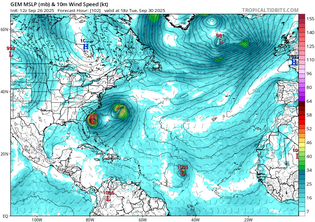
Teban54 wrote:12z CMC: You thought binary interactions were complex enough? How about... The Three-Body Problem?
https://i.postimg.cc/zvYxFFk3/gem-mslp-wind-atl-18.png
Full CMC run. In addition to the obviously wacky path for 94L, there's already the WSW-moving TC that's ready to take a shot at becoming an October Carribean storm.
1 likes
TC naming lists: retirements and intensity
Most aggressive Advisory #1's in North Atlantic (cr. kevin for starting the list)
Most aggressive Advisory #1's in North Atlantic (cr. kevin for starting the list)


Re: 2025 Global Model Runs Discussion (Out thru day 16)
The EPAC has been stealing all the thunder this season for west basin development.
Seems a little late in the game for them. I guess the MJO is not over the Gulf or Caribbean yet if it does happen at all.
Seems a little late in the game for them. I guess the MJO is not over the Gulf or Caribbean yet if it does happen at all.
0 likes
Re: 2025 Global Model Runs Discussion (Out thru day 16)


After EPAC calms down, the Caribbean should be active. Long range GFS and AIFS shows something in the NW Caribbean.
3 likes
Re: 2025 Global Model Runs Discussion (Out thru day 16)
Probably one-off, but 18z GFS randomly popped up a weak MDR TS. 12z CMC technically has something similar.
If this forms (and that's a big if), it would be one of those rare October MDR storms, even though not nearly as anomalous as last year.

If this forms (and that's a big if), it would be one of those rare October MDR storms, even though not nearly as anomalous as last year.
1 likes
TC naming lists: retirements and intensity
Most aggressive Advisory #1's in North Atlantic (cr. kevin for starting the list)
Most aggressive Advisory #1's in North Atlantic (cr. kevin for starting the list)
Re: 2025 Global Model Runs Discussion (Out thru day 16)
ECAI and EC has a tiny circulation forming in the central Gulf and the Bay of Campeche in 3 days.
3 likes
-
tropicwatch

- Category 5
- Posts: 3427
- Age: 62
- Joined: Sat Jun 02, 2007 10:01 am
- Location: The Villages, Florida
- Contact:
Re: 2025 Global Model Runs Discussion (Out thru day 16)
zzzh wrote:ECAI and EC has a tiny circulation forming in the central Gulf and the Bay of Campeche in 3 days.
Might already be happening. 925mb vorticity popped up there this afternoon.
2 likes
Tropicwatch
Agnes 72', Eloise 75, Elena 85', Kate 85', Charley 86', Florence 88', Beryl 94', Dean 95', Erin 95', Opal 95', Earl 98', Georges 98', Ivan 2004', Arlene 2005', Dennis 2005', Ida 2009' Debby 2012' Irma 2017' Michael 2018'
Agnes 72', Eloise 75, Elena 85', Kate 85', Charley 86', Florence 88', Beryl 94', Dean 95', Erin 95', Opal 95', Earl 98', Georges 98', Ivan 2004', Arlene 2005', Dennis 2005', Ida 2009' Debby 2012' Irma 2017' Michael 2018'
Re: 2025 Global Model Runs Discussion (Out thru day 16)
Looks like a low is there now in central gulf and convection popping. Models do anything with it?
1 likes
-
Frank P
- S2K Supporter

- Posts: 2779
- Joined: Fri Aug 29, 2003 10:52 am
- Location: Biloxi Beach, Ms
- Contact:
Re: 2025 Global Model Runs Discussion (Out thru day 16)
caneman wrote:Looks like a low is there now in central gulf and convection popping. Models do anything with it?
I notice that little swirl yesterday, and today it looks a little more interesting and definitely more vigorous. First time in months that anything at all has been in the Gulf. Does not appear to be moving much either.
2 likes
Re: 2025 Global Model Runs Discussion (Out thru day 16)
Per the latest Euro Weeklies: After Humberto and Imelda wind down ~10/4-5, there looks to be a brief break overall.
However, don’t get too comfortable as activity markedly picks up again to above normal on the run in the Gulf, NW Caribbean, and SW Atlantic (including Yucatan, Cuba, NC/NE US Gulf coast, FL/SE US coast, Bahamas, and Bermuda) with 140% of normal 10/13-19 and 160% of normal 10/20-26. This would be a 3rd peak of sorts for 2025 should it verify. This active period would resemble a somewhat toned down version of the freakishly active late seasons of 2020 and 2005 and similar to 1950, 1878, and 1870 for that area.
However, don’t get too comfortable as activity markedly picks up again to above normal on the run in the Gulf, NW Caribbean, and SW Atlantic (including Yucatan, Cuba, NC/NE US Gulf coast, FL/SE US coast, Bahamas, and Bermuda) with 140% of normal 10/13-19 and 160% of normal 10/20-26. This would be a 3rd peak of sorts for 2025 should it verify. This active period would resemble a somewhat toned down version of the freakishly active late seasons of 2020 and 2005 and similar to 1950, 1878, and 1870 for that area.
4 likes
Personal Forecast Disclaimer:
The posts in this forum are NOT official forecasts and should not be used as such. They are just the opinion of the poster and may or may not be backed by sound meteorological data. They are NOT endorsed by any professional institution or storm2k.org. For official information, please refer to the NHC and NWS products.
The posts in this forum are NOT official forecasts and should not be used as such. They are just the opinion of the poster and may or may not be backed by sound meteorological data. They are NOT endorsed by any professional institution or storm2k.org. For official information, please refer to the NHC and NWS products.
Re: 2025 Global Model Runs Discussion (Out thru day 16)
zzzh wrote:ECAI and EC has a tiny circulation forming in the central Gulf and the Bay of Campeche in 3 days.
Good catch! I wasn’t paying any attention to the Gulf at all due to Humberto and TD9. I just noticed on the most recent runs that just about all models have a weak but notable surface low/spin initialized in the C Gulf that then drifts SW to the Bay of Campeche, where it seems to stall just W of the Yucatan at ~hour 96. Interesting.
And lo and behold, there’s a TD on the UKMET (12Z) for the first time in the Bay of Campeche at hour 120 that then drifts N through the end of the run to a threatening position in the W central Gulf. I just saw new UK maps and this UK TD is from the same low that’s now in the C Gulf!
NEW TROPICAL CYCLONE FORECAST TO DEVELOP AFTER 120 HOURS
FORECAST POSITION AT T+120 : 20.7N 93.3W
LEAD CENTRAL MAXIMUM WIND
VERIFYING TIME TIME POSITION PRESSURE (MB) SPEED (KNOTS)
-------------- ---- -------- ------------- -------------
1200UTC 03.10.2025 120 20.7N 93.3W 1009 26
0000UTC 04.10.2025 132 21.1N 93.0W 1007 25
1200UTC 04.10.2025 144 22.3N 93.0W 1005 30
0000UTC 05.10.2025 156 22.8N 92.8W 1004 24
1200UTC 05.10.2025 168 24.4N 92.8W 1005 26
Edit: Check out the 12Z GFS at 168: there’s a TD that forms off of LA that then moves N into that state. That may or may not be directly related to the current C Gulf low, however, based on looking at vorticity maps.
1 likes
Personal Forecast Disclaimer:
The posts in this forum are NOT official forecasts and should not be used as such. They are just the opinion of the poster and may or may not be backed by sound meteorological data. They are NOT endorsed by any professional institution or storm2k.org. For official information, please refer to the NHC and NWS products.
The posts in this forum are NOT official forecasts and should not be used as such. They are just the opinion of the poster and may or may not be backed by sound meteorological data. They are NOT endorsed by any professional institution or storm2k.org. For official information, please refer to the NHC and NWS products.
-
ConvergenceZone
.gif)
- Category 5
- Posts: 5241
- Joined: Fri Jul 29, 2005 1:40 am
- Location: Northern California
Re: 2025 Global Model Runs Discussion (Out thru day 16)
Been a busy few days, but looking at the Global Models, not looking like much development for the next couple of weeks which will put us out to mid October range or so. I think we will get one more storm maybe in mid to late October before the season starts to wind down, maybe a carb cruising tropical storm or hurricane, but we will just have to wait and see.
0 likes
-
Weathertracker96
- Tropical Storm

- Posts: 150
- Joined: Mon Oct 16, 2023 3:41 pm
Re: 2025 Global Model Runs Discussion (Out thru day 16)
The CMC is showing a Gulf/CAG system.
1 likes
Re: 2025 Global Model Runs Discussion (Out thru day 16)
Weathertracker96 wrote:The CMC is showing a Gulf/CAG system.
Just to clarify for others. This 12Z CMC CAG low does not originate from the low that’s now in the C Gulf, which is what the 12Z UKMET forms its WC Gulf TD from.
1 likes
Personal Forecast Disclaimer:
The posts in this forum are NOT official forecasts and should not be used as such. They are just the opinion of the poster and may or may not be backed by sound meteorological data. They are NOT endorsed by any professional institution or storm2k.org. For official information, please refer to the NHC and NWS products.
The posts in this forum are NOT official forecasts and should not be used as such. They are just the opinion of the poster and may or may not be backed by sound meteorological data. They are NOT endorsed by any professional institution or storm2k.org. For official information, please refer to the NHC and NWS products.
-
TomballEd
- Category 5
- Posts: 1319
- Age: 62
- Joined: Wed Aug 16, 2023 4:52 pm
- Location: Spring/Klein area, not Tomball
Re: 2025 Global Model Runs Discussion (Out thru day 16)
Weathertracker96 wrote:The CMC is showing a Gulf/CAG system.
Larry Cosgrove thinks there may be 2 or 3 storms from the CAG, and it is possible one of them develops in the Gulf or crosses Tehuantepec into the Gulf. Florida has been unlucky with late season storms.
https://groups.google.com/g/weatheramerica/c/aauyOY32C94
Current GOMEX feature on the tail end of the trough almost certainly will not develop, it is in a desert.

0 likes
-
Weathertracker96
- Tropical Storm
- Posts: 150
- Joined: Mon Oct 16, 2023 3:41 pm
Re: 2025 Global Model Runs Discussion (Out thru day 16)
TomballEd wrote:Weathertracker96 wrote:The CMC is showing a Gulf/CAG system.
Larry Cosgrove thinks there may be 2 or 3 storms from the CAG, and it is possible one of them develops in the Gulf or crosses Tehuantepec into the Gulf. Florida has been unlucky with late season storms.
https://groups.google.com/g/weatheramerica/c/aauyOY32C94
Current GOMEX feature on the tail end of the trough almost certainly will not develop, it is in a desert.
https://i.imgur.com/0BOlYx4.gif
I agree. It seems October is a month FL has to really watch out for systems. With the way the steering has been, I’m especially on guard
0 likes
Who is online
Users browsing this forum: cycloneye, Majestic-12 [Bot], pepecool20 and 204 guests