NATL: HUMBERTO - Remnants - Discussion

Moderator: S2k Moderators

Message
Author
zhukm29
Category 1
Category 1
Posts: 351
Joined: Tue Aug 28, 2018 2:37 pm

Re: NATL: HUMBERTO - Hurricane - Discussion

#421 Postby zhukm29 » Sun Sep 28, 2025 11:55 pm

Big eye is ready to take over:

Image
Image
1 likes   

zhukm29
Category 1
Category 1
Posts: 351
Joined: Tue Aug 28, 2018 2:37 pm

Re: NATL: HUMBERTO - Hurricane - Discussion

#422 Postby zhukm29 » Mon Sep 29, 2025 12:04 am

Image
0 likes   

Sciencerocks
Category 5
Category 5
Posts: 9781
Age: 39
Joined: Thu Jul 06, 2017 1:51 am

Re: NATL: HUMBERTO - Hurricane - Discussion

#423 Postby Sciencerocks » Mon Sep 29, 2025 2:02 am

Image
1 likes   

User avatar
kevin
Category 5
Category 5
Posts: 2751
Age: 26
Joined: Wed Aug 28, 2019 4:35 am

Re: NATL: HUMBERTO - Hurricane - Discussion

#424 Postby kevin » Mon Sep 29, 2025 2:25 am

This is one of the coolest EWRCs I've seen. Usually they occur when shear and other factors are also becoming less optimal so the hurricane just sort of collapses for a while and you don't really see what's going on. But this time you can see all the inner workings while Humberto just keeps going. More than a full day into an EWRC and still a pressure in the 920s, can't say I've seen that before.
2 likes   

User avatar
kevin
Category 5
Category 5
Posts: 2751
Age: 26
Joined: Wed Aug 28, 2019 4:35 am

Re: NATL: HUMBERTO - Hurricane - Discussion

#425 Postby kevin » Mon Sep 29, 2025 2:27 am

Also based on Dvorak imagery the inner eyewall finally seems to have given up. Its final remains are being absorbed by the larger eyewall right now. And the larger eyewall already has a thin but closed W ring. Imagine what it'll look like if/when the larger eye fully clears out.

Image
0 likes   

User avatar
Hurricane2022
Category 5
Category 5
Posts: 1750
Joined: Tue Aug 23, 2022 11:38 pm
Location: Araçatuba, Brazil

Re: NATL: HUMBERTO - Hurricane - Discussion

#426 Postby Hurricane2022 » Mon Sep 29, 2025 2:31 am

Not sure if the eye will be ever able to clear again. The VWS seems to be already picking up and considerably fast.
0 likes   
Sorry for the bad English sometimes...!
For reliable and detailed information for any meteorological phenomenon, please consult the National Hurricane Center, Joint Typhoon Warning Center , or your local Meteo Center.

--------

Una cvm Christo, pro Christo, et in Christo. Sit nomen Domini benedictvm.

User avatar
aspen
Category 5
Category 5
Posts: 8918
Joined: Sat Oct 12, 2019 7:10 pm
Location: Connecticut, USA

Re: NATL: HUMBERTO - Hurricane - Discussion

#427 Postby aspen » Mon Sep 29, 2025 3:58 am

I’ve never seen such a stubborn inner eyewall. In any other storm, it would’ve been long gone by now and we would’ve seen a second peak.

Humberto is already starting to look a little squashed so it’s probably going to end up crippled and weakening from here on out.
0 likes   
Irene '11 Sandy '12 Hermine '16 5/15/2018 Derecho Fay '20 Isaias '20 Elsa '21 Henri '21 Ida '21

I am only a meteorology enthusiast who knows a decent amount about tropical cyclones. Look to the professional mets, the NHC, or your local weather office for the best information.

User avatar
cheezyWXguy
Category 5
Category 5
Posts: 6171
Joined: Mon Feb 13, 2006 12:29 am
Location: Dallas, TX

Re: NATL: HUMBERTO - Hurricane - Discussion

#428 Postby cheezyWXguy » Mon Sep 29, 2025 6:34 am

aspen wrote:I’ve never seen such a stubborn inner eyewall. In any other storm, it would’ve been long gone by now and we would’ve seen a second peak.

Humberto is already starting to look a little squashed so it’s probably going to end up crippled and weakening from here on out.

Yeah, it looks like the inner eyewall is gone now, but conditions seem to be deteriorating judging by the squashed NW side. Still a chance it could clear, but it may just stay a lumbering grungy monster with a cloud filled eye from this point on. Imelda picking up steam isn’t helping.
0 likes   

User avatar
cheezyWXguy
Category 5
Category 5
Posts: 6171
Joined: Mon Feb 13, 2006 12:29 am
Location: Dallas, TX

Re: NATL: HUMBERTO - Hurricane - Discussion

#429 Postby cheezyWXguy » Mon Sep 29, 2025 6:59 am

Recon finding pressure up another 10mb from last night. A secondary peak seems much less likely today imo
0 likes   

User avatar
cycloneye
Admin
Admin
Posts: 147751
Age: 69
Joined: Thu Oct 10, 2002 10:54 am
Location: San Juan, Puerto Rico

Re: NATL: HUMBERTO - Hurricane - Discussion

#430 Postby cycloneye » Mon Sep 29, 2025 7:03 am

AF plane found Humberto more stronger.

SUMMARY OF 800 AM AST...1200 UTC...INFORMATION

MAXIMUM SUSTAINED WINDS...145 MPH...230 KM/H.
1 likes   
Visit the Caribbean-Central America Weather Thread where you can find at first post web cams,radars
and observations from Caribbean basin members Click Here

MarioProtVI
Category 5
Category 5
Posts: 1002
Age: 24
Joined: Sun Sep 29, 2019 7:33 pm
Location: New Jersey

Re: NATL: HUMBERTO - Hurricane - Discussion

#431 Postby MarioProtVI » Mon Sep 29, 2025 7:10 am

cycloneye wrote:AF plane found Humberto more stronger.

SUMMARY OF 800 AM AST...1200 UTC...INFORMATION

MAXIMUM SUSTAINED WINDS...145 MPH...230 KM/H.

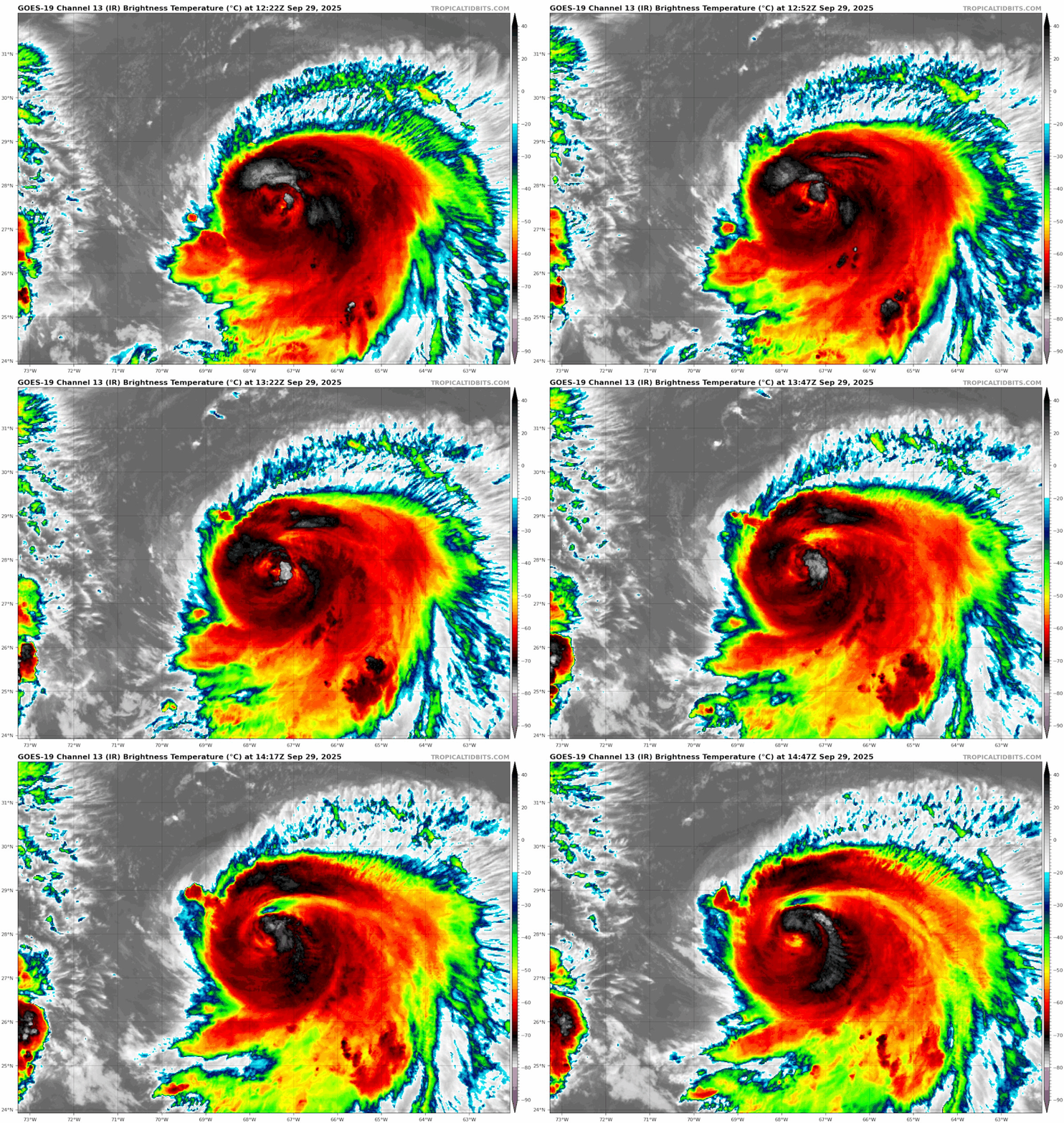
Really shows how critical recon is. Without it this would get at most 90 kt on satellite estimates.

Ironically this Humberto seems to be taking a page from 2019’s Humberto, where despite being sheared and a partially exposed LLC recon still found a solid major.
6 likes   

User avatar
cheezyWXguy
Category 5
Category 5
Posts: 6171
Joined: Mon Feb 13, 2006 12:29 am
Location: Dallas, TX

Re: NATL: HUMBERTO - Hurricane - Discussion

#432 Postby cheezyWXguy » Mon Sep 29, 2025 7:48 am

MarioProtVI wrote:
cycloneye wrote:AF plane found Humberto more stronger.

SUMMARY OF 800 AM AST...1200 UTC...INFORMATION

MAXIMUM SUSTAINED WINDS...145 MPH...230 KM/H.

Really shows how critical recon is. Without it this would get at most 90 kt on satellite estimates.

Ironically this Humberto seems to be taking a page from 2019’s Humberto, where despite being sheared and a partially exposed LLC recon still found a solid major.

No kidding, I never would have guessed they’d find stronger winds this morning. Between that, a pressure rise, and conditions becoming less favorable, I honestly don’t know what to think this will do. Guess I’ll just sit back and watch.
4 likes   

User avatar
sasha_B
Tropical Storm
Tropical Storm
Posts: 196
Age: 24
Joined: Sun Jun 30, 2024 4:32 pm
Location: Charleston, SC

Re: NATL: HUMBERTO - Hurricane - Discussion

#433 Postby sasha_B » Mon Sep 29, 2025 8:06 am

Central pressure filling in, but wind speeds also up, is pretty much the opposite of what I expected recon to find this morning given the observations last night. Very much looking forward to the TCR on Humberto.
0 likes   

zhukm29
Category 1
Category 1
Posts: 351
Joined: Tue Aug 28, 2018 2:37 pm

Re: NATL: HUMBERTO - Hurricane - Discussion

#434 Postby zhukm29 » Mon Sep 29, 2025 9:30 am

This dropsonde from earlier is pretty nuts:
Image
6 likes   

User avatar
Teban54
Category 5
Category 5
Posts: 3524
Joined: Sat May 19, 2018 1:19 pm

Re: NATL: HUMBERTO - Hurricane - Discussion

#435 Postby Teban54 » Mon Sep 29, 2025 10:01 am

One of the ugliest 125 kt Cat 4s that I've seen, which really shows the value of recon.

Image
5 likes   

User avatar
Hurricane2022
Category 5
Category 5
Posts: 1750
Joined: Tue Aug 23, 2022 11:38 pm
Location: Araçatuba, Brazil

Re: NATL: HUMBERTO - Hurricane - Discussion

#436 Postby Hurricane2022 » Mon Sep 29, 2025 10:10 am

zhukm29 wrote:This dropsonde from earlier is pretty nuts:
Image

If we didn't have IMELDA in the Bahamas with its immense outflow now, we possibly would be facing an even stronger Hurricane Humberto in the coming days. What a shame :x
Image
4 likes   
Sorry for the bad English sometimes...!
For reliable and detailed information for any meteorological phenomenon, please consult the National Hurricane Center, Joint Typhoon Warning Center , or your local Meteo Center.

--------

Una cvm Christo, pro Christo, et in Christo. Sit nomen Domini benedictvm.

zhukm29
Category 1
Category 1
Posts: 351
Joined: Tue Aug 28, 2018 2:37 pm

Re: NATL: HUMBERTO - Hurricane - Discussion

#437 Postby zhukm29 » Mon Sep 29, 2025 10:17 am

Hurricane2022 wrote:
zhukm29 wrote:This dropsonde from earlier is pretty nuts:
https://i.ibb.co/ymhfQgYs/HUMBERTO-AF308-0208-A-dropsonde-202509291144.png

If we didn't have IMELDA in the Bahamas with its immense outflow now, we possibly would be facing an even stronger Hurricane Humberto in the coming days. What a shame :x
https://i.imgur.com/74MpydH.jpeg


Imelda first stealing Humberto’s recon, and now stealing Humberto’s second peak - spoiled sibling energy :lol:
8 likes   

snowystar
Tropical Wave
Tropical Wave
Posts: 4
Joined: Thu Sep 17, 2020 3:33 pm

Re: NATL: HUMBERTO - Hurricane - Discussion

#438 Postby snowystar » Mon Sep 29, 2025 1:46 pm

zhukm29 wrote:
Hurricane2022 wrote:
zhukm29 wrote:This dropsonde from earlier is pretty nuts:
https://i.ibb.co/ymhfQgYs/HUMBERTO-AF308-0208-A-dropsonde-202509291144.png

If we didn't have IMELDA in the Bahamas with its immense outflow now, we possibly would be facing an even stronger Hurricane Humberto in the coming days. What a shame :x
https://i.imgur.com/74MpydH.jpeg


Imelda first stealing Humberto’s recon, and now stealing Humberto’s second peak - spoiled sibling energy :lol:


Next she will steal Humberto's Tropical Storm Watch

A Tropical Storm Watch means that tropical storm conditions are
possible within the watch area, generally within 48 hours. This
Tropical Storm Watch may be replaced with a Hurricane Watch later
today due to Imelda.
4 likes   

User avatar
cheezyWXguy
Category 5
Category 5
Posts: 6171
Joined: Mon Feb 13, 2006 12:29 am
Location: Dallas, TX

Re: NATL: HUMBERTO - Hurricane - Discussion

#439 Postby cheezyWXguy » Mon Sep 29, 2025 6:25 pm

MarioProtVI wrote:
cycloneye wrote:AF plane found Humberto more stronger.

SUMMARY OF 800 AM AST...1200 UTC...INFORMATION

MAXIMUM SUSTAINED WINDS...145 MPH...230 KM/H.

Really shows how critical recon is. Without it this would get at most 90 kt on satellite estimates.

Ironically this Humberto seems to be taking a page from 2019’s Humberto, where despite being sheared and a partially exposed LLC recon still found a solid major.

Feel like I need to refer back to this post from earlier today again, as it’s become even more true since. In its current state, this Humberto is less “taking a page” from Humberto 2019 and more “writing the sequel” :lol: Yet another Humberto clinging to major status as its center comes closer to being exposed.
1 likes   

User avatar
aspen
Category 5
Category 5
Posts: 8918
Joined: Sat Oct 12, 2019 7:10 pm
Location: Connecticut, USA

Re: NATL: HUMBERTO - Hurricane - Discussion

#440 Postby aspen » Mon Sep 29, 2025 6:25 pm

Humberto’s intensity has caught up to its structural degradation. Pressure is now in the mid 950s, winds support a mid Cat 3.
2 likes   
Irene '11 Sandy '12 Hermine '16 5/15/2018 Derecho Fay '20 Isaias '20 Elsa '21 Henri '21 Ida '21

I am only a meteorology enthusiast who knows a decent amount about tropical cyclones. Look to the professional mets, the NHC, or your local weather office for the best information.


Return to “2025”

Who is online

Users browsing this forum: No registered users and 28 guests