Tropical Wave well south of the Cabo Verde Islands (Is Invest 95L)
Moderator: S2k Moderators
Forum rules

The posts in this forum are NOT official forecasts and should not be used as such. They are just the opinion of the poster and may or may not be backed by sound meteorological data. They are NOT endorsed by any professional institution or STORM2K. For official information, please refer to products from the National Hurricane Center and National Weather Service.
-
floridasun
- Tropical Storm

- Posts: 245
- Joined: Tue Sep 14, 2021 3:59 pm
Re: Tropical Wave to emerge West Africa in a day or two (0/20)
i not worry about system may form week from now we need see how pay out models runs
0 likes
-
MarioProtVI
- Category 5

- Posts: 1039
- Age: 24
- Joined: Sun Sep 29, 2019 7:33 pm
- Location: New Jersey
Re: Tropical Wave to emerge West Africa in a day or two (0/20)
If that were to pan out that would easily bring 2025 to above average. That’s not even counting what happens beyond the end of the run as it goes into the Gulf
1 likes
-
Coolcruiseman
- Tropical Depression

- Posts: 97
- Age: 52
- Joined: Wed Sep 21, 2022 8:10 pm
- Location: Melbourne, FL
Re: Tropical Wave to emerge West Africa in a day or two (0/20)
Fully get the general “recurve” from CONUS due to fronts based on historical data. However what is the possibility of October being the new September with a MDR storm coming this late?
0 likes
-
TomballEd
- Category 5
- Posts: 1318
- Age: 62
- Joined: Wed Aug 16, 2023 4:52 pm
- Location: Spring/Klein area, not Tomball
Re: Tropical Wave to emerge West Africa in a day or two (0/20)
Coolcruiseman wrote:Fully get the general “recurve” from CONUS due to fronts based on historical data. However what is the possibility of October being the new September with a MDR storm coming this late?
Euro op at 360 hours should be treated like just another ensemble member. But a recurve into the Gulf and to the eastern Gulf seems quite possible.
0 likes
-
Stratton23
- Category 5
- Posts: 3574
- Joined: Fri Jul 21, 2023 10:59 pm
- Location: Katy, Tx
Re: Tropical Wave to emerge from West Africa in a day or two (0/20)
Worth watching this one because the PNA is expected to stay strong negative through the next 2 weeks, that means we likely will not see much troughing off the SE coast because of the SE Ridge , worth watching because this one could get pretty far west
1 likes


Re: Tropical Wave to emerge from West Africa in a day or two (0/20)
if it verified that would mean the force field over the western basin has failed us.

2 likes
-
cycloneye

- Admin

- Posts: 149696
- Age: 69
- Joined: Thu Oct 10, 2002 10:54 am
- Location: San Juan, Puerto Rico
Re: Tropical Wave to emerge from West Africa in a day or two (0/30)
Tropical Weather Outlook
NWS National Hurricane Center Miami FL
800 PM EDT Thu Oct 2 2025
Central Tropical Atlantic:
A tropical wave is expected to move off the coast of Africa over the
next day or two. Thereafter, this wave is forecast to interact with
another disturbance in the eastern tropical Atlantic, and some slow
development of the combined feature is possible as the system moves
westward to west-northwestward at 15 to 20 mph.
* Formation chance through 48 hours...low...near 0 percent.
* Formation chance through 7 days...low...30 percent.
0 likes
Visit the Caribbean-Central America Weather Thread where you can find at first post web cams,radars
and observations from Caribbean basin members Click Here
and observations from Caribbean basin members Click Here

Re: Tropical Wave to emerge from West Africa in a day or two (0/30)
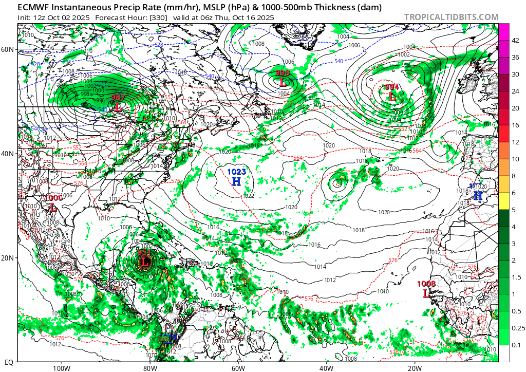
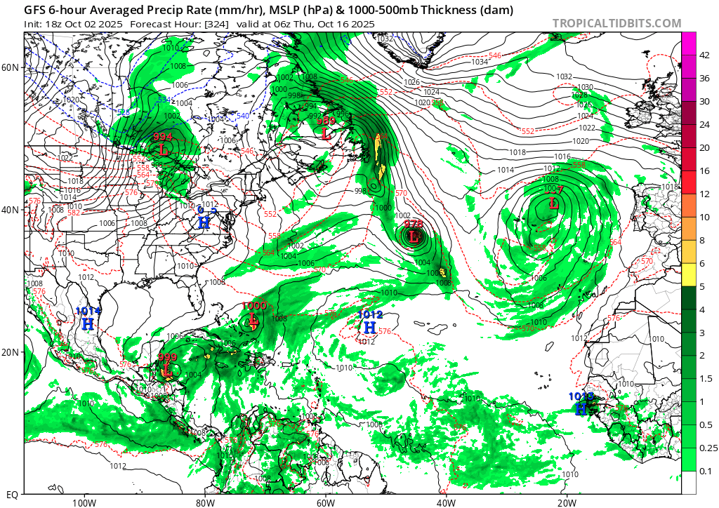
Perhaps the most dramatic display of GFS (18z) vs. Euro (12z)... Same storm, one about to transition to extratropical while the other in the Western Caribbean.
(It's long range, yes I know)
(It's long range, yes I know)
1 likes
TC naming lists: retirements and intensity
Most aggressive Advisory #1's in North Atlantic (cr. kevin for starting the list)
Most aggressive Advisory #1's in North Atlantic (cr. kevin for starting the list)
-
TallyTracker
- Category 2

- Posts: 787
- Joined: Thu Oct 11, 2018 2:46 pm
Re: Tropical Wave to emerge from West Africa in a day or two (0/30)
Teban54 wrote:Perhaps the most dramatic display of GFS (18z) vs. Euro (12z)... Same storm, one about to transition to extratropical while the other in the Western Caribbean.
(It's long range, yes I know)
[url]https://i.postimg.cc/FsCdcc5S/ecmwf-mslp-pcpn-atl-79.png [/url]
[url]https://i.postimg.cc/ZK5vCHg6/gfs-mslp-pcpn-atl-54.png [/url]
When I read this, I expected the GFS to be in the Caribbean and the Euro to be the one out in the North Atlantic…turns out to be the opposite! lol
4 likes
Fran '96, Georges '98, Gordon '00, Gabrielle '01, Charley '04, Frances '04, Jeanne '04, Barry '07, Fay '08, Debby '12, Matthew '16, Emily '17, Irma '17, Michael ‘18, Elsa ‘21, Fred ‘21, Mindy ‘21, Nicole ‘22, Idalia ‘23, Debby ‘24, Helene ‘24


Re: Tropical Wave to emerge from West Africa in a day or two (0/30)
9 likes
Andy D
(For official information, please refer to the NHC and NWS products.)
(For official information, please refer to the NHC and NWS products.)
-
cycloneye
- Admin
- Posts: 149696
- Age: 69
- Joined: Thu Oct 10, 2002 10:54 am
- Location: San Juan, Puerto Rico
Re: Tropical Wave to emerge from West Africa in a day or two (0/30)
Getting ready to make the splash.

3 likes
Visit the Caribbean-Central America Weather Thread where you can find at first post web cams,radars
and observations from Caribbean basin members Click Here
and observations from Caribbean basin members Click Here
Re: Tropical Wave to emerge West Africa in a day or two (0/30)
Coolcruiseman wrote:Fully get the general “recurve” from CONUS due to fronts based on historical data. However what is the possibility of October being the new September with a MDR storm coming this late?
Getting an MDR storm this late isn’t that unusual as I count ~75 storms since 1851 on record as having been born in the MDR at or E of the Lesser Antilles in Oct or later. However, no TC on record (since 1851) located E of 55W after Oct. 4th has ever hit the Conus. Storm #9 of 1893, which formed in the E MDR on Sept. 25th, is the latest on record TCG E of 55W that hit the Conus. This was located at 55W on Oct. 4th and hit SC on Oct. 13th.
There have been several TCs that formed between 55W and 60W on or after Sept. 25th that later hit the Conus. This includes storm 7 of 1898, which formed on Sept. 25th near 58W, and Hazel of 1954, which formed on Oct. 5th near 58W.
Thus based on this very long history, I’d be more concerned about a potential Conus hit from this if it were to become TC W of 55W, which is when many ops/ensemble members have TCG. If it were to become a TC E of 55W, then I’d obviously be less concerned.
Last edited by LarryWx on Thu Oct 02, 2025 10:25 pm, edited 2 times in total.
0 likes
Personal Forecast Disclaimer:
The posts in this forum are NOT official forecasts and should not be used as such. They are just the opinion of the poster and may or may not be backed by sound meteorological data. They are NOT endorsed by any professional institution or storm2k.org. For official information, please refer to the NHC and NWS products.
The posts in this forum are NOT official forecasts and should not be used as such. They are just the opinion of the poster and may or may not be backed by sound meteorological data. They are NOT endorsed by any professional institution or storm2k.org. For official information, please refer to the NHC and NWS products.
-
emeraldislenc
- Category 2
- Posts: 601
- Joined: Fri Aug 24, 2012 4:49 pm
- Location: Emerald Isle NC
Re: Tropical Wave to emerge from West Africa in a day or two (0/30)
We need to remember before Satellites many times storms were not detected as early as they are now.
I think we can't say for certain about where a hurricane began.
I think we can't say for certain about where a hurricane began.
1 likes
-
AutoPenalti
- Category 5
- Posts: 4091
- Age: 29
- Joined: Mon Aug 17, 2015 4:16 pm
- Location: Ft. Lauderdale, Florida
Re: Tropical Wave to emerge from West Africa in a day or two (0/30)
FWIW tail end of the ensembles recurve this away.
1 likes
The posts in this forum are NOT official forecasts and should not be used as such. They are just the opinion of the poster and may or may not be backed by sound meteorological data. They are NOT endorsed by any professional institution or STORM2K. For official information, please refer to products from the NHC and NWS.
Model Runs Cheat Sheet:
GFS (5:30 AM/PM, 11:30 AM/PM)
HWRF, GFDL, UKMET, NAVGEM (6:30-8:00 AM/PM, 12:30-2:00 AM/PM)
ECMWF (1:45 AM/PM)
TCVN is a weighted averaged
Re: Tropical Wave to emerge from West Africa in a day or two (0/30)
emeraldislenc wrote:We need to remember before Satellites many times storms were not detected as early as they are now.
I think we can't say for certain about where a hurricane began.
I agree 100%. However, consider that since 1851 there have been ~150 TCGs E of 55W after Sept 25th and not even one of those 150 made it to the Conus! That by itself says a lot. Also, consider that the satellite era covers 65 years and not one did so during those 65 years, which is still a pretty long period.
That of course isn’t at all saying it’s impossible for an E of 55W TCG in October in the future to later hit the Conus. A first on record is always possible and would inevitably finally occur. Maybe even the 151st on record would be the first to do it. However, what that is saying to me is that the chance of any one doing it is extremely low. Otherwise, there wouldn’t be 150 in a row on record not hitting. It could easily be many decades or more before it finally happens.
1 likes
Personal Forecast Disclaimer:
The posts in this forum are NOT official forecasts and should not be used as such. They are just the opinion of the poster and may or may not be backed by sound meteorological data. They are NOT endorsed by any professional institution or storm2k.org. For official information, please refer to the NHC and NWS products.
The posts in this forum are NOT official forecasts and should not be used as such. They are just the opinion of the poster and may or may not be backed by sound meteorological data. They are NOT endorsed by any professional institution or storm2k.org. For official information, please refer to the NHC and NWS products.
-
AJC3

- Admin
- Posts: 4156
- Age: 62
- Joined: Tue Aug 31, 2004 7:04 pm
- Location: Ballston Spa, New York
- Contact:
Re: Tropical Wave to emerge from West Africa in a day or two (0/30)
Tropical Weather Outlook
NWS National Hurricane Center Miami FL
200 AM EDT Fri Oct 3 2025
Central Tropical Atlantic:
A tropical wave is expected to move off the coast of Africa over the
next day or two. Thereafter, this wave is forecast to interact with
another disturbance in the eastern tropical Atlantic, and some slow
development of the combined feature is possible as the system moves
westward to west-northwestward at 15 to 20 mph.
* Formation chance through 48 hours...low...near 0 percent.
* Formation chance through 7 days...low...30 percent.
1 likes
Re: Tropical Wave to emerge from West Africa in a day or two (0/30)
I didn’t post it. But the 12Z UKMET had a TC form at 162 hours and already recurving/moving NW to 23.7N, 57.2W at 168.
The new one (0Z) forms it 18 hours earlier and it moves WNW instead of NW meaning it ends up much further S than the 12Z run had it at the end of the run (~150 miles NE of the Leewards):
The new one (0Z) forms it 18 hours earlier and it moves WNW instead of NW meaning it ends up much further S than the 12Z run had it at the end of the run (~150 miles NE of the Leewards):
NEW TROPICAL CYCLONE FORECAST TO DEVELOP AFTER 132 HOURS
FORECAST POSITION AT T+132 : 15.7N 53.2W
LEAD CENTRAL MAXIMUM WIND
VERIFYING TIME TIME POSITION PRESSURE (MB) SPEED (KNOTS)
-------------- ---- -------- ------------- -------------
1200UTC 08.10.2025 132 15.7N 53.2W 1009 40
0000UTC 09.10.2025 144 17.5N 56.5W 1009 39
1200UTC 09.10.2025 156 18.8N 59.3W 1009 34
0000UTC 10.10.2025 168 19.7N 61.4W 1008 31
1 likes
Personal Forecast Disclaimer:
The posts in this forum are NOT official forecasts and should not be used as such. They are just the opinion of the poster and may or may not be backed by sound meteorological data. They are NOT endorsed by any professional institution or storm2k.org. For official information, please refer to the NHC and NWS products.
The posts in this forum are NOT official forecasts and should not be used as such. They are just the opinion of the poster and may or may not be backed by sound meteorological data. They are NOT endorsed by any professional institution or storm2k.org. For official information, please refer to the NHC and NWS products.
-
cycloneye
- Admin
- Posts: 149696
- Age: 69
- Joined: Thu Oct 10, 2002 10:54 am
- Location: San Juan, Puerto Rico
Re: Tropical Wave moving off West Africa (0/40)
8 AM:
Central Tropical Atlantic:
A tropical wave is expected to move off the coast of Africa today.
The wave is forecast to interact with another disturbance over the
eastern tropical Atlantic, and then move westward after that.
Environmental conditions are expected to become conducive for some
slow development of the system in a few days, and a tropical
depression could form near or east of the Lesser Antilles by the end
of next week.
* Formation chance through 48 hours...low...near 0 percent.
* Formation chance through 7 days...medium...40 percent.
$$
0 likes
Visit the Caribbean-Central America Weather Thread where you can find at first post web cams,radars
and observations from Caribbean basin members Click Here
and observations from Caribbean basin members Click Here
-
TomballEd
- Category 5
- Posts: 1318
- Age: 62
- Joined: Wed Aug 16, 2023 4:52 pm
- Location: Spring/Klein area, not Tomball
Re: Tropical Wave moving off West Africa (0/40)
This probably recurves, but growing up on Long Island, this gets far enough West, a Sandy scenario of trough capture. Has to reach about 70W, I assume. A few members of both big ensembles get it into the Caribbean.
It looks promising so far. Not on topic, but ensembles suggest this won't be the last AEW to develop. October is the new September, albeit with recurve even more likely.

It looks promising so far. Not on topic, but ensembles suggest this won't be the last AEW to develop. October is the new September, albeit with recurve even more likely.
0 likes
-
cycloneye
- Admin
- Posts: 149696
- Age: 69
- Joined: Thu Oct 10, 2002 10:54 am
- Location: San Juan, Puerto Rico
Re: Tropical Wave moving off West Africa (0/40)
0 likes
Visit the Caribbean-Central America Weather Thread where you can find at first post web cams,radars
and observations from Caribbean basin members Click Here
and observations from Caribbean basin members Click Here
Who is online
Users browsing this forum: No registered users and 189 guests