
94W INVEST 251002 1200 17.1N 149.6E WPAC 15 0
WPAC: HALONG - Post-Tropical
Moderator: S2k Moderators
WPAC: HALONG - Post-Tropical
Last edited by Hayabusa on Mon Oct 06, 2025 7:17 pm, edited 5 times in total.
0 likes
ヤンデレ女が寝取られるているのを見たい!!!
ECMWF ensemble NWPAC plots: https://ecmwfensnwpac.imgbb.com/
Multimodel NWPAC plots: https://multimodelnwpac.imgbb.com/
GFS Ensemble NWPAC plots (16 & 35 day forecast): https://gefsnwpac.imgbb.com/
Plots updated automatically
ECMWF ensemble NWPAC plots: https://ecmwfensnwpac.imgbb.com/
Multimodel NWPAC plots: https://multimodelnwpac.imgbb.com/
GFS Ensemble NWPAC plots (16 & 35 day forecast): https://gefsnwpac.imgbb.com/
Plots updated automatically
Re: WPAC: INVEST 94W
Although not yet in the surface map, JMA is monitoring this through early dvorak analysis since 06z.
0 likes
ヤンデレ女が寝取られるているのを見たい!!!
ECMWF ensemble NWPAC plots: https://ecmwfensnwpac.imgbb.com/
Multimodel NWPAC plots: https://multimodelnwpac.imgbb.com/
GFS Ensemble NWPAC plots (16 & 35 day forecast): https://gefsnwpac.imgbb.com/
Plots updated automatically
ECMWF ensemble NWPAC plots: https://ecmwfensnwpac.imgbb.com/
Multimodel NWPAC plots: https://multimodelnwpac.imgbb.com/
GFS Ensemble NWPAC plots (16 & 35 day forecast): https://gefsnwpac.imgbb.com/
Plots updated automatically
Re: WPAC: INVEST 94W
Now low
ABPW10 PGTW 031500
MSGID/GENADMIN/JOINT TYPHOON WRNCEN PEARL HARBOR HI//
SUBJ/SIGNIFICANT TROPICAL WEATHER ADVISORY FOR THE WESTERN AND SOUTH
PACIFIC OCEANS REISSUED/031500Z-040600ZOCT2025//
REF/A/MSG/JOINT TYPHOON WRNCEN PEARL HARBOR HI/030751ZOCT2025//
AMPN/REF A IS A TROPICAL CYCLONE WARNING.//
RMKS/
1. WESTERN NORTH PACIFIC AREA (180 TO MALAY PENINSULA):
A. TROPICAL CYCLONE SUMMARY:
(1) AT 03OCT25 1200Z, TROPICAL STORM 27W (MATMO) WAS LOCATED
NEAR 17.5N 119.4E, APPROXIMATELY 197 NM NORTH-NORTHWEST OF MANILA,
PHILIPPINES, AND HAD TRACKED WEST- NORTHWESTWARD AT 15 KNOTS OVER THE
PAST SIX HOURS. MAXIMUM SUSTAINED SURFACE WINDS WERE ESTIMATED AT
60 KNOTS GUSTING TO 75 KNOTS. SEE REF A (WTPN31 PGTW 031500)
FOR FURTHER DETAILS.
(2) NO OTHER TROPICAL CYCLONES.
B. TROPICAL DISTURBANCE SUMMARY:
(1) AN AREA OF CONVECTION (INVEST 94W) HAS PERSISTED NEAR 21.6N
144.7E, APPROXIMATELY 264 NM SOUTHEAST OF IWO TO, JAPAN. AANIMATED
ENHANCED INFRARED IMAGERY (EIR) AS WELL AS A 031122Z METOP-B ASCAT PASS
REVEAL A VERY BROAD AREA OF TURNING WITH FLARING CONVECTION OVER THE
EASTERN PERIPHERY WITH NO DISCERNABLE LLCC. THE AFOREMENTIONED ASCAT
PASS FURTHER HIGHLIGHTS THE WAVE LIKE NATURE OF THIS AREA (94W) WITH
WRAPPING 10-15KT WINDS ALONG THE EASTERN BOUNDARY AND WEAK MULTI
DIRECTIONAL WINDS ALONG THE WESTERN BOUNDARY. ENVIRONMENTAL CONDITIONS
FOR THIS SYSTEM INDICATE MARGINALLY FAVORABLE CONDITIONS WITH LOW TO
MODERATE VERTICAL WIND SHEAR (15-20KT), WARM SEA SURFACE TEMPERATURES
(28-29C) AND MODERATE OUTFLOW ALOFT. GLOBAL DETERMINISTIC MODELS ARE IN
GOOD AGREEMENT THAT 94W WILL CONTINUE TO TRACK WEST OVER THE NEXT 48-72
HOURS AND GRADUALLY CONSOLIDATE. MAXIMUM SUSTAINED SURFACE WINDS ARE
ESTIMATED AT 18 TO 23 KNOTS. MINIMUM SEA LEVEL PRESSURE IS ESTIMATED TO
BE NEAR 1011 MB. THE POTENTIAL FOR THE DEVELOPMENT OF A SIGNIFICANT
TROPICAL CYCLONE WITHIN THE NEXT 24 HOURS IS LOW.
(2) NO OTHER SUSPECT AREAS.
C. SUBTROPICAL SYSTEM SUMMARY: NONE.
2. SOUTH PACIFIC AREA (WEST COAST OF SOUTH AMERICA TO 135 EAST):
A. TROPICAL CYCLONE SUMMARY: NONE.
B. TROPICAL DISTURBANCE SUMMARY: NONE.
C. SUBTROPICAL SYSTEM SUMMARY: NONE.
3. JUSTIFICATION FOR REISSUE: ADDED LOW AREA IN PARA 1.B.(1)//
NNNN
0 likes
ヤンデレ女が寝取られるているのを見たい!!!
ECMWF ensemble NWPAC plots: https://ecmwfensnwpac.imgbb.com/
Multimodel NWPAC plots: https://multimodelnwpac.imgbb.com/
GFS Ensemble NWPAC plots (16 & 35 day forecast): https://gefsnwpac.imgbb.com/
Plots updated automatically
ECMWF ensemble NWPAC plots: https://ecmwfensnwpac.imgbb.com/
Multimodel NWPAC plots: https://multimodelnwpac.imgbb.com/
GFS Ensemble NWPAC plots (16 & 35 day forecast): https://gefsnwpac.imgbb.com/
Plots updated automatically
Re: WPAC: INVEST 94W
Up to medium and JMA TD
ABPW10 PGTW 040300
MSGID/GENADMIN/JOINT TYPHOON WRNCEN PEARL HARBOR HI//
SUBJ/SIGNIFICANT TROPICAL WEATHER ADVISORY FOR THE WESTERN AND SOUTH
PACIFIC OCEANS REISSUED/040300Z-040600ZOCT2025//
REF/A/MSG/JOINT TYPHOON WRNCEN PEARL HARBOR HI/040151ZOCT2025//
AMPN/REF A IS A TROPICAL CYCLONE WARNING.//
RMKS/
1. WESTERN NORTH PACIFIC AREA (180 TO MALAY PENINSULA):
A. TROPICAL CYCLONE SUMMARY:
(1) AT 04OCT25 0000Z, TROPICAL STORM 27W (MATMO) WAS LOCATED NEAR
18.2N 116.7E, APPROXIMATELY 283 NM SOUTH-SOUTHEAST OF HONG KONG, AND
HAD TRACKED WEST-NORTHWESTWARD AT 13 KNOTS OVER THE PAST SIX HOURS.
MAXIMUM SUSTAINED SURFACE WINDS WERE ESTIMATED AT 60 KNOTS GUSTING TO
75 KNOTS. SEE REF A (WTPN31 PGTW 040300) FOR FURTHER DETAILS.
(2) NO OTHER TROPICAL CYCLONES.
B. TROPICAL DISTURBANCE SUMMARY:
(1) THE AREA OF CONVECTION (INVEST 94W) PREVIOUSLY LOCATED NEAR
21.6N 144.7E IS NOW LOCATED NEAR 23.4N 143.1E, APPROXIMATELY 129 NM
SOUTHEAST OF IWO TO. ANIMATED MULTISPECTRAL SATELLITE IMAGERY DEPICTS
AN OBSCURED, LOW LEVEL CIRCULATION CENTER (LLCC) WITH PERSISTENT
CONVECTION OVER THE CENTER. A RECENT 040040Z ASCAT-C 25 KM PASS REVEALS
A CIRCULATION WITH 20-25 KNOTS ALONG THE EASTERN QUADRANT AND 5-15 KNOTS
ELSEWHERE. ENVIRONMENTAL ANALYSIS REVEALS A MARGINALLY FAVORABLE
ENVIRONMENT WITH LOW TO MODERATE LEVEL VERTICAL WIND SHEAR OF 15-20
KNOTS, GOOD DUAL CHANNEL UPPER-LEVEL OUTFLOW, AND WARM SEA SURFACE
TEMPERATURES (SST) OF 29-30 C. GLOBAL MODELS ARE NOT IN AGREEMENT UPON
INTENSITY BUT DO CONCUR WITH A WESTWARD TRACK TOWARD TAIWAN. MAXIMUM
SUSTAINED SURFACE WINDS ARE ESTIMATED AT 18 TO 23 KNOTS. MINIMUM SEA
LEVEL PRESSURE IS ESTIMATED TO BE NEAR 1006 MB. THE POTENTIAL FOR THE
DEVELOPMENT OF A SIGNIFICANT TROPICAL CYCLONE WITHIN THE NEXT 24 HOURS
IS UPGRADED TO MEDIUM.
(2) NO OTHER SUSPECT AREAS.
C. SUBTROPICAL SYSTEM SUMMARY: NONE.
2. SOUTH PACIFIC AREA (WEST COAST OF SOUTH AMERICA TO 135 EAST):
A. TROPICAL CYCLONE SUMMARY: NONE.
B. TROPICAL DISTURBANCE SUMMARY: NONE.
C. SUBTROPICAL SYSTEM SUMMARY: NONE.
3. JUSTIFICATION FOR REISSUE: UPGRADED AREA IN PARA 1.B.(1) TO
MEDIUM.//
NNNN
WWJP27 RJTD 040000
WARNING AND SUMMARY 040000.
WARNING VALID 050000.
WARNING IS UPDATED EVERY 6 HOURS.
TROPICAL DEPRESSION 1008 HPA AT 24N 144E WNW SLOWLY.
WARNING AND SUMMARY 040000.
WARNING VALID 050000.
WARNING IS UPDATED EVERY 6 HOURS.
TROPICAL DEPRESSION 1008 HPA AT 24N 144E WNW SLOWLY.
1 likes
ヤンデレ女が寝取られるているのを見たい!!!
ECMWF ensemble NWPAC plots: https://ecmwfensnwpac.imgbb.com/
Multimodel NWPAC plots: https://multimodelnwpac.imgbb.com/
GFS Ensemble NWPAC plots (16 & 35 day forecast): https://gefsnwpac.imgbb.com/
Plots updated automatically
ECMWF ensemble NWPAC plots: https://ecmwfensnwpac.imgbb.com/
Multimodel NWPAC plots: https://multimodelnwpac.imgbb.com/
GFS Ensemble NWPAC plots (16 & 35 day forecast): https://gefsnwpac.imgbb.com/
Plots updated automatically
Re: WPAC: INVEST 94W
Tcfa jtwc
0 likes
ヤンデレ女が寝取られるているのを見たい!!!
ECMWF ensemble NWPAC plots: https://ecmwfensnwpac.imgbb.com/
Multimodel NWPAC plots: https://multimodelnwpac.imgbb.com/
GFS Ensemble NWPAC plots (16 & 35 day forecast): https://gefsnwpac.imgbb.com/
Plots updated automatically
ECMWF ensemble NWPAC plots: https://ecmwfensnwpac.imgbb.com/
Multimodel NWPAC plots: https://multimodelnwpac.imgbb.com/
GFS Ensemble NWPAC plots (16 & 35 day forecast): https://gefsnwpac.imgbb.com/
Plots updated automatically
Re: WPAC: INVEST 94W
Jma tc warning
0 likes
ヤンデレ女が寝取られるているのを見たい!!!
ECMWF ensemble NWPAC plots: https://ecmwfensnwpac.imgbb.com/
Multimodel NWPAC plots: https://multimodelnwpac.imgbb.com/
GFS Ensemble NWPAC plots (16 & 35 day forecast): https://gefsnwpac.imgbb.com/
Plots updated automatically
ECMWF ensemble NWPAC plots: https://ecmwfensnwpac.imgbb.com/
Multimodel NWPAC plots: https://multimodelnwpac.imgbb.com/
GFS Ensemble NWPAC plots (16 & 35 day forecast): https://gefsnwpac.imgbb.com/
Plots updated automatically
Re: WPAC: INVEST 94W
If this enters the PAR it would be named Quedan and the fourth consecutive use of the name that didn't affect the Philippines...or would it?
0 likes
ヤンデレ女が寝取られるているのを見たい!!!
ECMWF ensemble NWPAC plots: https://ecmwfensnwpac.imgbb.com/
Multimodel NWPAC plots: https://multimodelnwpac.imgbb.com/
GFS Ensemble NWPAC plots (16 & 35 day forecast): https://gefsnwpac.imgbb.com/
Plots updated automatically
ECMWF ensemble NWPAC plots: https://ecmwfensnwpac.imgbb.com/
Multimodel NWPAC plots: https://multimodelnwpac.imgbb.com/
GFS Ensemble NWPAC plots (16 & 35 day forecast): https://gefsnwpac.imgbb.com/
Plots updated automatically
Re: WPAC: 94W - Tropical Depression
Pagasa has also upgraded it to a TD
0 likes
ヤンデレ女が寝取られるているのを見たい!!!
ECMWF ensemble NWPAC plots: https://ecmwfensnwpac.imgbb.com/
Multimodel NWPAC plots: https://multimodelnwpac.imgbb.com/
GFS Ensemble NWPAC plots (16 & 35 day forecast): https://gefsnwpac.imgbb.com/
Plots updated automatically
ECMWF ensemble NWPAC plots: https://ecmwfensnwpac.imgbb.com/
Multimodel NWPAC plots: https://multimodelnwpac.imgbb.com/
GFS Ensemble NWPAC plots (16 & 35 day forecast): https://gefsnwpac.imgbb.com/
Plots updated automatically
Re: WPAC: 94W - Tropical Depression
Models differ where it would go, Euro AI and GFS show recurve while Euro a westward track toward east coast of China.
0 likes
ヤンデレ女が寝取られるているのを見たい!!!
ECMWF ensemble NWPAC plots: https://ecmwfensnwpac.imgbb.com/
Multimodel NWPAC plots: https://multimodelnwpac.imgbb.com/
GFS Ensemble NWPAC plots (16 & 35 day forecast): https://gefsnwpac.imgbb.com/
Plots updated automatically
ECMWF ensemble NWPAC plots: https://ecmwfensnwpac.imgbb.com/
Multimodel NWPAC plots: https://multimodelnwpac.imgbb.com/
GFS Ensemble NWPAC plots (16 & 35 day forecast): https://gefsnwpac.imgbb.com/
Plots updated automatically
Re: WPAC: 28W - Tropical Depression
28W TWENTYEIGH 251004 1200 24.8N 143.3E WPAC 30 1003
0 likes
ヤンデレ女が寝取られるているのを見たい!!!
ECMWF ensemble NWPAC plots: https://ecmwfensnwpac.imgbb.com/
Multimodel NWPAC plots: https://multimodelnwpac.imgbb.com/
GFS Ensemble NWPAC plots (16 & 35 day forecast): https://gefsnwpac.imgbb.com/
Plots updated automatically
ECMWF ensemble NWPAC plots: https://ecmwfensnwpac.imgbb.com/
Multimodel NWPAC plots: https://multimodelnwpac.imgbb.com/
GFS Ensemble NWPAC plots (16 & 35 day forecast): https://gefsnwpac.imgbb.com/
Plots updated automatically
Re: WPAC: 28W - Tropical Depression
06z eps

0 likes
ヤンデレ女が寝取られるているのを見たい!!!
ECMWF ensemble NWPAC plots: https://ecmwfensnwpac.imgbb.com/
Multimodel NWPAC plots: https://multimodelnwpac.imgbb.com/
GFS Ensemble NWPAC plots (16 & 35 day forecast): https://gefsnwpac.imgbb.com/
Plots updated automatically
ECMWF ensemble NWPAC plots: https://ecmwfensnwpac.imgbb.com/
Multimodel NWPAC plots: https://multimodelnwpac.imgbb.com/
GFS Ensemble NWPAC plots (16 & 35 day forecast): https://gefsnwpac.imgbb.com/
Plots updated automatically
-
ElectricStorm

- Category 5

- Posts: 5164
- Age: 25
- Joined: Tue Aug 13, 2019 11:23 pm
- Location: Norman, OK
Re: WPAC: 28W - Tropical Depression
105kts at the end of the first JTWC forecast. Looks like this will be the next strong typhoon.
0 likes
B.S Meteorology, University of Oklahoma '25
Please refer to the NHC, NWS, or SPC for official information.
Please refer to the NHC, NWS, or SPC for official information.
-
Sciencerocks
- Category 5
- Posts: 10194
- Age: 40
- Joined: Thu Jul 06, 2017 1:51 am

Re: WPAC: HALONG - Tropical Storm
Halong's back
T2522(Halong)
Issued at 2025/10/04 19:30 UTC
Analysis at 10/04 18 UTC
Grade TS
Scale -
Intensity -
Center position N25°05′ (25.1°)
E143°50′ (143.8°)
Direction and speed of movement W Slow
Central pressure 1002 hPa
Maximum sustained wind speed near center 18 m/s (35 kt)
Maximum wind gust speed 25 m/s (50 kt)
Radius of 30-kt wind area NE330 km (180 NM)
SW220 km (120 NM)
1 likes
ヤンデレ女が寝取られるているのを見たい!!!
ECMWF ensemble NWPAC plots: https://ecmwfensnwpac.imgbb.com/
Multimodel NWPAC plots: https://multimodelnwpac.imgbb.com/
GFS Ensemble NWPAC plots (16 & 35 day forecast): https://gefsnwpac.imgbb.com/
Plots updated automatically
ECMWF ensemble NWPAC plots: https://ecmwfensnwpac.imgbb.com/
Multimodel NWPAC plots: https://multimodelnwpac.imgbb.com/
GFS Ensemble NWPAC plots (16 & 35 day forecast): https://gefsnwpac.imgbb.com/
Plots updated automatically
-
cycloneye

- Admin

- Posts: 149843
- Age: 69
- Joined: Thu Oct 10, 2002 10:54 am
- Location: San Juan, Puerto Rico
Re: WPAC: HALONG - Tropical Storm
0 likes
Visit the Caribbean-Central America Weather Thread where you can find at first post web cams,radars
and observations from Caribbean basin members Click Here
and observations from Caribbean basin members Click Here


Re: WPAC: HALONG - Tropical Storm
Halong has an increasingly evident eye in visible and LWIR imagery. It's likely very close to typhoon status if not already there.
0 likes
Re: WPAC: HALONG - Tropical Storm
Halong seems to be approaching T5.0 with eye temperatures occasionally positive now but the JTWC indicates that Halong is has weakened slightly (or, rather, held intensity) on Best Track. This is a Severe Tropical Storm per JMA, though - sustained winds are up to 60 kts on their latest advisory.
0 likes

Re: WPAC: HALONG - Typhoon
Bombing out.
0 likes
TC naming lists: retirements and intensity
Most aggressive Advisory #1's in North Atlantic (cr. kevin for starting the list)
Most aggressive Advisory #1's in North Atlantic (cr. kevin for starting the list)
-
Hurricane2022

- Category 5
- Posts: 2096
- Joined: Tue Aug 23, 2022 11:38 pm
- Location: Araçatuba, Brazil
Re: WPAC: HALONG - Typhoon
0 likes
Sorry for the bad English sometimes...!
For reliable and detailed information for any meteorological phenomenon, please consult the National Hurricane Center, Joint Typhoon Warning Center , or your local Meteo Center.
--------
ECCE OMNIA NOVA FACIAM (Ap 21,5).
For reliable and detailed information for any meteorological phenomenon, please consult the National Hurricane Center, Joint Typhoon Warning Center , or your local Meteo Center.
--------
ECCE OMNIA NOVA FACIAM (Ap 21,5).
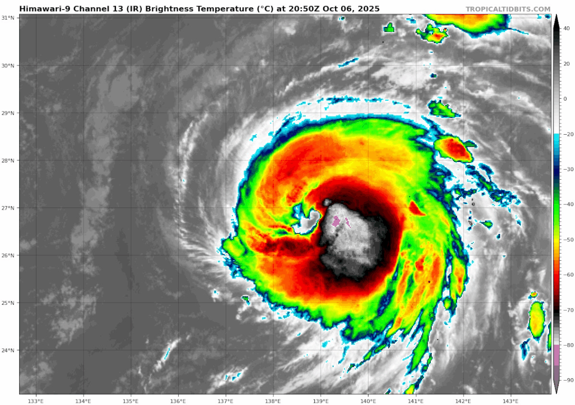
Re: WPAC: HALONG - Typhoon
Cat 4
28W HALONG 251007 1200 28.1N 137.3E WPAC 115 942
1 likes
ヤンデレ女が寝取られるているのを見たい!!!
ECMWF ensemble NWPAC plots: https://ecmwfensnwpac.imgbb.com/
Multimodel NWPAC plots: https://multimodelnwpac.imgbb.com/
GFS Ensemble NWPAC plots (16 & 35 day forecast): https://gefsnwpac.imgbb.com/
Plots updated automatically
ECMWF ensemble NWPAC plots: https://ecmwfensnwpac.imgbb.com/
Multimodel NWPAC plots: https://multimodelnwpac.imgbb.com/
GFS Ensemble NWPAC plots (16 & 35 day forecast): https://gefsnwpac.imgbb.com/
Plots updated automatically
Who is online
Users browsing this forum: No registered users and 24 guests