BULLETIN
Tropical Storm Priscilla Advisory Number 2
NWS National Hurricane Center Miami FL EP162025
800 PM MST Sat Oct 04 2025
...PRISCILLA MOVING SLOWLY NORTHWESTWARD...
...TROPICAL STORM WATCH IN EFFECT FOR PORTIONS OF THE COAST OF
SOUTHWESTERN MEXICO...
SUMMARY OF 800 PM MST...0300 UTC...INFORMATION
----------------------------------------------
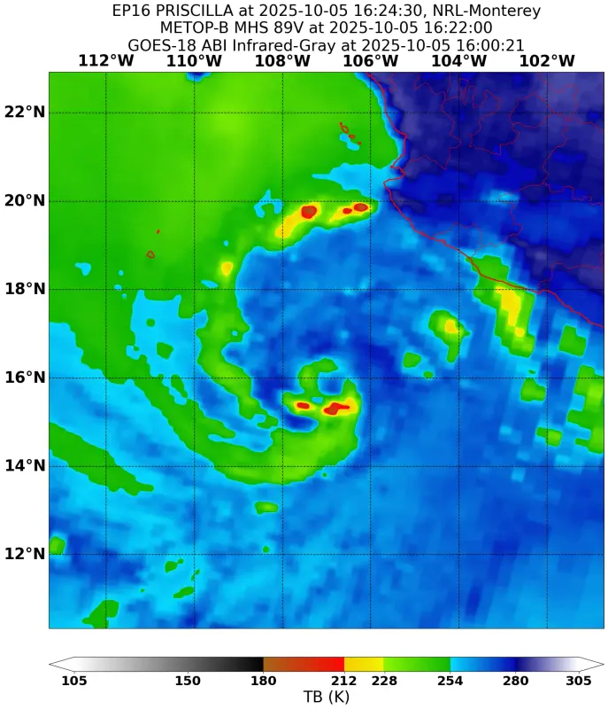
LOCATION...15.6N 106.7W
ABOUT 285 MI...455 KM SW OF MANZANILLO MEXICO
ABOUT 545 MI...880 KM SSE OF THE SOUTHERN TIP OF BAJA CALIFORNIA
MAXIMUM SUSTAINED WINDS...45 MPH...75 KM/H
PRESENT MOVEMENT...NW OR 325 DEGREES AT 3 MPH...6 KM/H
MINIMUM CENTRAL PRESSURE...1000 MB...29.53 INCHES
Tropical Storm Priscilla Discussion Number 2
NWS National Hurricane Center Miami FL EP162025
800 PM MST Sat Oct 04 2025
The satellite presentation of Priscilla suggests the storm is
contending with some shear this evening. The low-level circulation
appears to be partially exposed to the east of the central
convection. Large curved bands wrap around the northern and western
parts of the circulation. The satellite intensity estimates range
from 36-45 kt, and the initial intensity is held at 40 kt based on a
blend of these estimates and the earlier scatterometer data.
The initial motion estimate is an uncertain 325/3 kt. Priscilla has
not moved much since earlier today, and recent satellite images
suggest there could be a couple of small vortices rotating around a
broader system center. While Priscilla continues to organize and the
storm remains in weak steering currents, a slow and erratic
northward to northwestward motion is expected during the next day or
so. By Monday, a somewhat faster northwestward motion is forecast
while Priscilla moves between a strengthening ridge over northern
Mexico and an upper-level trough over the western U.S. The
cross-track model spread increases greatly at days 3-5. This is
likely related to differences in the amplitude of the upper trough
off the U.S. West Coast, and the strength and positioning of the
ridge over northern Mexico during this period. The 96-120 h NHC
track forecast was adjusted a bit slower and farther left, following
the latest model trends and remaining between the simple and
corrected consensus aids.
Despite the storm's large size, most of the intensity guidance
favors steady to even significant strengthening over the next few
days. Warm sea-surface temperatures and strong upper-level
divergence should provide favorable conditions for intensification
once Priscilla consolidates an inner core. There are indications
that moderate easterly shear will persist into early next week, but
the large system should be less susceptible to those negative
effects once its structure improves. The NHC forecast shows
Priscilla reaching hurricane strength by Monday with some continued
strengthening thereafter. A weakening trend is forecast beyond 72 h
as Priscilla is expected to encounter cooler waters and a drier,
more stable environment while gaining latitude.
KEY MESSAGES:
1. Tropical storm conditions are possible along portions of the
coast of southwestern Mexico within the watch area Sunday and
Monday. Interests in the southern portion of Baja California Sur
should monitor the progress of Priscilla.
2. Heavy rainfall associated with Priscilla will impact coastal
sections of southwestern Mexico through Monday, which could result
in flash flooding, particularly in areas of higher terrain.
3. Swells generated by Priscilla are affecting portions of
the coast of southwestern Mexico and will reach the coasts of
west-central Mexico and the southern Baja California peninsula by
Monday. These swells are likely to cause life-threatening surf and
rip current conditions.
FORECAST POSITIONS AND MAX WINDS
INIT 05/0300Z 15.6N 106.7W 40 KT 45 MPH
12H 05/1200Z 16.0N 106.8W 50 KT 60 MPH
24H 06/0000Z 16.6N 107.1W 60 KT 70 MPH
36H 06/1200Z 17.4N 107.8W 65 KT 75 MPH
48H 07/0000Z 18.4N 108.8W 75 KT 85 MPH
60H 07/1200Z 19.3N 110.0W 80 KT 90 MPH
72H 08/0000Z 20.2N 111.4W 80 KT 90 MPH
96H 09/0000Z 22.3N 114.1W 70 KT 80 MPH
120H 10/0000Z 24.5N 116.5W 50 KT 60 MPH
$$
Forecaster Reinhart
Tropical Storm Priscilla Advisory Number 2
NWS National Hurricane Center Miami FL EP162025
800 PM MST Sat Oct 04 2025
...PRISCILLA MOVING SLOWLY NORTHWESTWARD...
...TROPICAL STORM WATCH IN EFFECT FOR PORTIONS OF THE COAST OF
SOUTHWESTERN MEXICO...
SUMMARY OF 800 PM MST...0300 UTC...INFORMATION
----------------------------------------------
LOCATION...15.6N 106.7W
ABOUT 285 MI...455 KM SW OF MANZANILLO MEXICO
ABOUT 545 MI...880 KM SSE OF THE SOUTHERN TIP OF BAJA CALIFORNIA
MAXIMUM SUSTAINED WINDS...45 MPH...75 KM/H
PRESENT MOVEMENT...NW OR 325 DEGREES AT 3 MPH...6 KM/H
MINIMUM CENTRAL PRESSURE...1000 MB...29.53 INCHES
Tropical Storm Priscilla Discussion Number 2
NWS National Hurricane Center Miami FL EP162025
800 PM MST Sat Oct 04 2025
The satellite presentation of Priscilla suggests the storm is
contending with some shear this evening. The low-level circulation
appears to be partially exposed to the east of the central
convection. Large curved bands wrap around the northern and western
parts of the circulation. The satellite intensity estimates range
from 36-45 kt, and the initial intensity is held at 40 kt based on a
blend of these estimates and the earlier scatterometer data.
The initial motion estimate is an uncertain 325/3 kt. Priscilla has
not moved much since earlier today, and recent satellite images
suggest there could be a couple of small vortices rotating around a
broader system center. While Priscilla continues to organize and the
storm remains in weak steering currents, a slow and erratic
northward to northwestward motion is expected during the next day or
so. By Monday, a somewhat faster northwestward motion is forecast
while Priscilla moves between a strengthening ridge over northern
Mexico and an upper-level trough over the western U.S. The
cross-track model spread increases greatly at days 3-5. This is
likely related to differences in the amplitude of the upper trough
off the U.S. West Coast, and the strength and positioning of the
ridge over northern Mexico during this period. The 96-120 h NHC
track forecast was adjusted a bit slower and farther left, following
the latest model trends and remaining between the simple and
corrected consensus aids.
Despite the storm's large size, most of the intensity guidance
favors steady to even significant strengthening over the next few
days. Warm sea-surface temperatures and strong upper-level
divergence should provide favorable conditions for intensification
once Priscilla consolidates an inner core. There are indications
that moderate easterly shear will persist into early next week, but
the large system should be less susceptible to those negative
effects once its structure improves. The NHC forecast shows
Priscilla reaching hurricane strength by Monday with some continued
strengthening thereafter. A weakening trend is forecast beyond 72 h
as Priscilla is expected to encounter cooler waters and a drier,
more stable environment while gaining latitude.
KEY MESSAGES:
1. Tropical storm conditions are possible along portions of the
coast of southwestern Mexico within the watch area Sunday and
Monday. Interests in the southern portion of Baja California Sur
should monitor the progress of Priscilla.
2. Heavy rainfall associated with Priscilla will impact coastal
sections of southwestern Mexico through Monday, which could result
in flash flooding, particularly in areas of higher terrain.
3. Swells generated by Priscilla are affecting portions of
the coast of southwestern Mexico and will reach the coasts of
west-central Mexico and the southern Baja California peninsula by
Monday. These swells are likely to cause life-threatening surf and
rip current conditions.
FORECAST POSITIONS AND MAX WINDS
INIT 05/0300Z 15.6N 106.7W 40 KT 45 MPH
12H 05/1200Z 16.0N 106.8W 50 KT 60 MPH
24H 06/0000Z 16.6N 107.1W 60 KT 70 MPH
36H 06/1200Z 17.4N 107.8W 65 KT 75 MPH
48H 07/0000Z 18.4N 108.8W 75 KT 85 MPH
60H 07/1200Z 19.3N 110.0W 80 KT 90 MPH
72H 08/0000Z 20.2N 111.4W 80 KT 90 MPH
96H 09/0000Z 22.3N 114.1W 70 KT 80 MPH
120H 10/0000Z 24.5N 116.5W 50 KT 60 MPH
$$
Forecaster Reinhart