EPAC: PRISCILLA - Post-Tropical

Moderator: S2k Moderators

Message
Author
User avatar
cycloneye
Admin
Admin
Posts: 147741
Age: 69
Joined: Thu Oct 10, 2002 10:54 am
Location: San Juan, Puerto Rico

Re: EPAC: PRISCILLA - Hurricane

#41 Postby cycloneye » Mon Oct 06, 2025 3:43 pm

BULLETIN
Hurricane Priscilla Advisory Number 9
NWS National Hurricane Center Miami FL EP162025
200 PM MST Mon Oct 06 2025

...HEAVY RAINS AND GUSTY WINDS POSSIBLE THROUGH TODAY OVER PARTS OF
COASTAL WEST-CENTRAL MEXICO...
...TROPICAL STORM CONDITIONS POSSIBLE ACROSS PORTIONS OF BAJA
CALIFORNIA SUR TUESDAY NIGHT AND WEDNESDAY...


SUMMARY OF 200 PM MST...2100 UTC...INFORMATION
----------------------------------------------
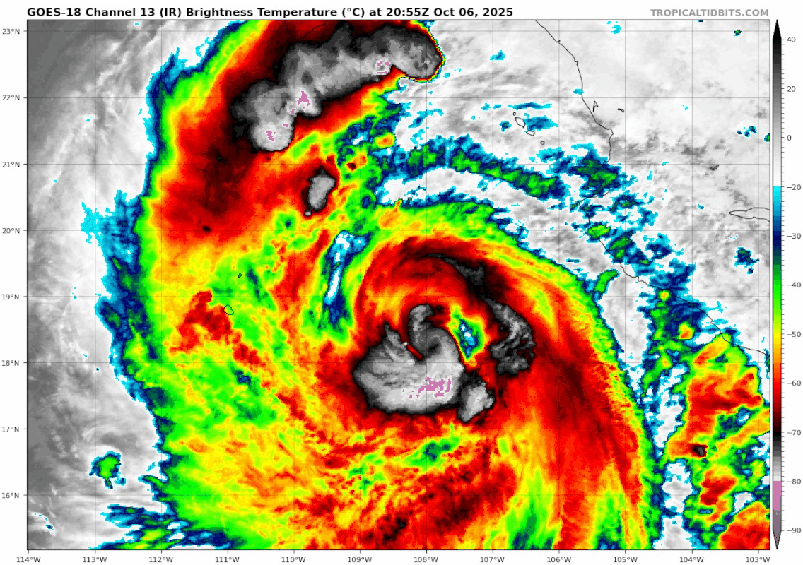
LOCATION...18.3N 108.0W
ABOUT 210 MI...335 KM SW OF CABO CORRIENTES MEXICO
ABOUT 340 MI...550 KM SSE OF THE SOUTHERN TIP OF BAJA CALIFORNIA
MAXIMUM SUSTAINED WINDS...85 MPH...140 KM/H
PRESENT MOVEMENT...NNW OR 340 DEGREES AT 7 MPH...11 KM/H
MINIMUM CENTRAL PRESSURE...972 MB...28.71 INCHES


Hurricane Priscilla Discussion Number 9
NWS National Hurricane Center Miami FL EP162025
200 PM MST Mon Oct 06 2025

Priscilla has a very large area of banded convection that spirals
into a central area that has shown signs of some clearing from
time-to-time. Satellite intensity estimates haven't changed much
from the previous advisory. A recent ASCAT pass from 06/1604 UTC
shows that the system still has a large radius of maximum winds
(RMW). The strongest vectors of 50-55 kt were mainly located in the
eastern semicircle. It's possible that slightly stronger winds
could be located just outside the edge of the scatterometer pass.
The initial intensity is maintained at 75 kt, but this could be a
bit generous.

Priscilla is moving a bit faster toward the north-northwest, or 340
degrees at 6 kt. A more northwestward track with some
slight additional acceleration is expected by this evening as
mid-level ridging becomes better established over Mexico. The model
guidance has come into slightly better agreement through 72 hours.
Beyond 72 hours, a turn toward the north is expected as a trough
just off the coast of California picks up the cyclone. The latest
NHC forecast has been adjusted slightly to the right of the
previous forecast, and is a bit faster at day 4 and 5. The new NHC
track lies slightly to the left of the HFIP Corrected Consensus
(HCCA) and Google DeepMind Ensemble Mean.

The inner core and RMW of Priscilla has not contracted yet, and the
hurricane has also not strengthened over the past 12 hours.
Moderate vertical wind shear and some sneaky dry slots noted on
water vapor imagery could be preventing Priscilla from developing a
tight inner core. Until that happens, only slow strengthening
is anticipated. The NHC intensity forecast is similar to, but
slightly lower than the previous forecast, and lies near the middle
of the guidance envelope. Priscilla is forecast reach colder
waters, and the system is forecast to weaken below hurricane
strength shortly after that time. Priscilla is likely to lose its
deep convection and become a remnant low just beyond 96 h. The
weakening circulation could reach the northern Baja California
peninsula just before it dissipates. Enhanced moisture is likely to
make its way toward portions of the southwestern United States.


KEY MESSAGES:

1. Tropical storm conditions are possible along portions of the
coast of west-central Mexico through today, and in Baja California
Sur Tuesday night into Wednesday, within the watch areas. Interests
elsewhere in the Baja California peninsula should monitor the
progress of Priscilla.

2. Heavy rainfall associated with Priscilla will impact portions of
southern Baja California Sur, which could result in flash flooding,
particularly in areas of higher terrain.

3. Swells generated by Priscilla are affecting portions of the
coast of southwestern and west-central Mexico as well as the coast
of the southern Baja California peninsula. These swells are likely
to cause life-threatening surf and rip current conditions.


FORECAST POSITIONS AND MAX WINDS

INIT 06/2100Z 18.3N 108.0W 75 KT 85 MPH
12H 07/0600Z 19.1N 108.9W 80 KT 90 MPH
24H 07/1800Z 20.0N 110.2W 90 KT 105 MPH
36H 08/0600Z 20.9N 111.5W 90 KT 105 MPH
48H 08/1800Z 22.0N 112.8W 80 KT 90 MPH
60H 09/0600Z 23.1N 114.0W 70 KT 80 MPH
72H 09/1800Z 24.3N 114.8W 55 KT 65 MPH
96H 10/1800Z 27.0N 115.4W 35 KT 40 MPH
120H 11/1800Z 30.0N 114.5W 20 KT 25 MPH...POST-TROP/REMNT LOW

$$
Forecaster Hagen
0 likes   
Visit the Caribbean-Central America Weather Thread where you can find at first post web cams,radars
and observations from Caribbean basin members Click Here

User avatar
Teban54
Category 5
Category 5
Posts: 3521
Joined: Sat May 19, 2018 1:19 pm

Re: EPAC: PRISCILLA - Hurricane

#42 Postby Teban54 » Mon Oct 06, 2025 9:02 pm

Certainly dealing with dry air (which IIRC is not uncommon for storms on this path), but look like Priscilla is still trying.

Image
0 likes   

User avatar
cycloneye
Admin
Admin
Posts: 147741
Age: 69
Joined: Thu Oct 10, 2002 10:54 am
Location: San Juan, Puerto Rico

Re: EPAC: PRISCILLA - Hurricane

#43 Postby cycloneye » Mon Oct 06, 2025 9:50 pm

BULLETIN
Hurricane Priscilla Advisory Number 10
NWS National Hurricane Center Miami FL EP162025
800 PM MST Mon Oct 06 2025

...HEAVY RAINS AND GUSTY WINDS POSSIBLE OVER PORTIONS OF BAJA
CALIFORNIA SUR ON TUESDAY AND WEDNESDAY AS PRISCILLA MOVES NEARBY...


SUMMARY OF 800 PM MST...0300 UTC...INFORMATION
----------------------------------------------
LOCATION...19.1N 108.5W
ABOUT 205 MI...325 KM WSW OF CABO CORRIENTES MEXICO
ABOUT 275 MI...445 KM SSE OF THE SOUTHERN TIP OF BAJA CALIFORNIA
MAXIMUM SUSTAINED WINDS...85 MPH...140 KM/H
PRESENT MOVEMENT...NW OR 320 DEGREES AT 9 MPH...15 KM/H
MINIMUM CENTRAL PRESSURE...972 MB...28.71 INCHES


Hurricane Priscilla Discussion Number 10
NWS National Hurricane Center Miami FL EP162025
800 PM MST Mon Oct 06 2025

Priscilla remains a large hurricane this evening, with broad curved
bands developing and rotating around the center on GOES-18 satellite
imagery. Since the prior advisory, there was a 0057 UTC WSF-M
microwave pass that showed the inner-core starting to tighten up
with a nearly closed 37-GHz cyan ring. This may foreshadow a period
of more intensification in the near future. Subjective Dvorak
estimates from TAFB/SAB remain unchanged from earlier today at
T4.5/77-kt and objective intensity estimates from UW-CIMSS range
from 68-78 kt, so the initial intensity remains 75 kt for this
advisory.

The hurricane appears to finally be moving a little faster to the
northwest, with the estimated motion at 320/8 kt. A continued
northwestward track with a little faster forward motion is expected
over the next 24-48 hours as ridging becomes re-established to the
northeast of Priscilla. After this time, an amplifying shortwave
trough is expected to cutoff just off the Western U.S. coastline,
eroding the ridge north of the hurricane. In response, the majority
of the guidance shows Priscilla turning northward as it moves in the
flow between the ridge and the digging trough. The track guidance
shifted a little more right this cycle, and the NHC track was nudged
in that direction. However, it still remains slower and not as far
right as some of the hurricane-regional models and the ECMWF track
forecast, remaining close to a blend of the HFIP Corrected Consensus
Approach (HCCA) and Google DeepMind ensemble mean (GDMI).

The improving core structure on microwave imagery suggests that
Priscilla might be finally ready to intensify a little more in the
short term. With shear remaining between 15-20 kt, and sea-surface
temperatures (SSTs) remaining above 28 C for the next 24-36 h, the
hurricane is expected to intensify and reach a peak intensity during
this time. Afterwards, Priscilla is expected to cross a sharp SST
gradient into much cooler water, leading to steady weakening beyond
36 hours. The NHC intensity forecast is similar to the prior
advisory, electing to remain close to the HCCA intensity aid. Shear
also increases rapidly after 72 h, and the tropical cyclone could
lose its remaining convection right as it approaches the Baja
California coastline, leading to the system becoming a remnant low.
Regardless, enhanced moisture is likely to make its way toward
portions of the southwestern United States during the latter half
of this week.


KEY MESSAGES:

1. Tropical storm conditions are possible along the Baja California
Sur Pacific coastline Tuesday night into Wednesday, within the
Tropical Storm Watch area. Interests elsewhere in the Baja
California peninsula should monitor the progress of Priscilla.

2. Heavy rainfall associated with Priscilla will impact portions of
southern Baja California Sur, which could result in flash flooding,
particularly in areas of higher terrain.

3. Swells generated by Priscilla are affecting portions of the
coast of southwestern and west-central Mexico as well as the coast
of the southern Baja California peninsula. These swells are likely
to cause life-threatening surf and rip current conditions.


FORECAST POSITIONS AND MAX WINDS

INIT 07/0300Z 19.1N 108.5W 75 KT 85 MPH
12H 07/1200Z 19.8N 109.6W 85 KT 100 MPH
24H 08/0000Z 20.7N 110.9W 90 KT 105 MPH
36H 08/1200Z 21.6N 112.1W 85 KT 100 MPH
48H 09/0000Z 22.8N 113.4W 70 KT 80 MPH
60H 09/1200Z 24.0N 114.5W 55 KT 65 MPH
72H 10/0000Z 25.2N 115.1W 45 KT 50 MPH
96H 11/0000Z 27.4N 115.3W 30 KT 35 MPH
120H 12/0000Z 29.7N 114.3W 20 KT 25 MPH...POST-TROP/REMNT LOW

$$
Forecaster Papin
0 likes   
Visit the Caribbean-Central America Weather Thread where you can find at first post web cams,radars
and observations from Caribbean basin members Click Here

User avatar
cycloneye
Admin
Admin
Posts: 147741
Age: 69
Joined: Thu Oct 10, 2002 10:54 am
Location: San Juan, Puerto Rico

Re: EPAC: PRISCILLA - Hurricane

#44 Postby cycloneye » Tue Oct 07, 2025 3:57 am

BULLETIN
Hurricane Priscilla Advisory Number 11
NWS National Hurricane Center Miami FL EP162025
200 AM MST Tue Oct 07 2025

...PRISCILLA IS STRENGTHENING...
...OUTER BANDS COULD BRING HEAVY RAINS AND GUSTY WINDS TO PORTIONS
OF BAJA CALIFORNIA SUR LATER TODAY AND WEDNESDAY...


SUMMARY OF 200 AM MST...0900 UTC...INFORMATION
----------------------------------------------
LOCATION...19.4N 109.5W
ABOUT 255 MI...410 KM WSW OF CABO CORRIENTES MEXICO
ABOUT 245 MI...390 KM S OF THE SOUTHERN TIP OF BAJA CALIFORNIA
MAXIMUM SUSTAINED WINDS...100 MPH...155 KM/H
PRESENT MOVEMENT...NW OR 310 DEGREES AT 10 MPH...17 KM/H
MINIMUM CENTRAL PRESSURE...967 MB...28.56 INCHES


Hurricane Priscilla Discussion Number 11
NWS National Hurricane Center Miami FL EP162025
200 AM MST Tue Oct 07 2025

Priscilla is strengthening early this morning. The inner core
structure has improved, with deep convective cloud tops surrounding
the center of the hurricane. An eye feature has recently emerged in
proxy-visible and infrared satellite images. ASCAT-C data from 04
UTC show the tropical-storm-force wind field remains quite broad,
but the radius of maximum wind appears to have contracted from prior
estimates. The initial intensity is raised to 85 kt, representing a
blend of recent UW-CIMSS DPRINT estimates (79-87 kt) and a 5.0/90 kt
Dvorak classification from TAFB at 06 UTC.

The intensity of Priscilla is likely to peak in the next 12-24 h
while the hurricane remains over warm waters and in a moist,
moderate shear environment. Given the rapidly improving satellite
structure, the NHC forecast shows Priscilla nearing major hurricane
strength later today, in best agreement with the HAFS regional
models. Thereafter, the hurricane is expected to move over
progressively cooler waters and into a drier mid-level environment
while gaining latitude. Thus, the NHC forecast calls for steady
weakening beginning Wednesday and continuing through the rest of the
week. Southwesterly shear is forecast to increase over Priscilla as
it approaches the Baja California peninsula in 96-120 h, and
Priscilla could become post-tropical by late Friday or Saturday if
its convection is stripped away as shown in the GFS and ECMWF
simulated satellite imagery. This enhanced moisture is likely to be
transported northward over portions of the southwestern U.S. late
this week, resulting in the potential for heavy rainfall.

The hurricane is moving northwestward (310/9 kt) around the
southwestern portion of a mid-level ridge over northern Mexico. This
motion should continue for the next couple of days while the center
of Priscilla moves parallel to, but remains offshore of, the
southern Baja California peninsula. By Thursday, an amplifying
trough off the U.S. West Coast is forecast to erode the steering
ridge to the north of Priscilla. The weakness in the ridge should
induce a northward turn later this week and into the weekend. The
updated NHC track forecast lies slightly to the left of the
previous prediction. This is mostly related to an initial position
adjustment based on earlier microwave and scatterometer data that
indicated Priscilla was slightly south of previous estimates.


KEY MESSAGES:

1. Tropical storm conditions are possible along the Baja California
Sur Pacific coastline within the Tropical Storm Watch area later
today into Wednesday. Interests elsewhere in the Baja California
peninsula should monitor the progress of Priscilla.

2. Heavy rainfall associated with Priscilla will impact portions of
southern Baja California Sur, which could result in flash flooding,
particularly in areas of higher terrain.

3. Swells generated by Priscilla are affecting portions of the
coast of southwestern and west-central Mexico as well as the coast
of the southern Baja California peninsula. These swells are likely
to cause life-threatening surf and rip current conditions.


FORECAST POSITIONS AND MAX WINDS

INIT 07/0900Z 19.4N 109.5W 85 KT 100 MPH
12H 07/1800Z 20.0N 110.4W 95 KT 110 MPH
24H 08/0600Z 20.9N 111.8W 95 KT 110 MPH
36H 08/1800Z 21.9N 113.0W 85 KT 100 MPH
48H 09/0600Z 23.0N 114.2W 70 KT 80 MPH
60H 09/1800Z 24.3N 115.1W 55 KT 65 MPH
72H 10/0600Z 25.5N 115.4W 45 KT 50 MPH
96H 11/0600Z 27.7N 115.5W 30 KT 35 MPH...POST-TROP/REMNT LOW
120H 12/0600Z 30.5N 114.0W 20 KT 25 MPH...POST-TROP/REMNT LOW

$$
Forecaster Reinhart
0 likes   
Visit the Caribbean-Central America Weather Thread where you can find at first post web cams,radars
and observations from Caribbean basin members Click Here

User avatar
sasha_B
Tropical Storm
Tropical Storm
Posts: 196
Age: 24
Joined: Sun Jun 30, 2024 4:32 pm
Location: Charleston, SC

Re: EPAC: PRISCILLA - Hurricane

#45 Postby sasha_B » Tue Oct 07, 2025 9:37 am

ADT estimates for Priscilla have reached 5.5 (final) and 6.5 (instantaneous). It appears to be at or near major hurricane strength.
0 likes   

User avatar
cycloneye
Admin
Admin
Posts: 147741
Age: 69
Joined: Thu Oct 10, 2002 10:54 am
Location: San Juan, Puerto Rico

Re: EPAC: PRISCILLA - Hurricane

#46 Postby cycloneye » Tue Oct 07, 2025 10:08 am

BULLETIN
Hurricane Priscilla Advisory Number 12
NWS National Hurricane Center Miami FL EP162025
800 AM MST Tue Oct 07 2025

...PRISCILLA STRENGTHENS...
...OUTER BANDS ARE AFFECTING THE SOUTHERN BAJA CALIFORNIA
PENINSULA...


SUMMARY OF 800 AM MST...1500 UTC...INFORMATION
----------------------------------------------
LOCATION...19.8N 110.1W
ABOUT 290 MI...465 KM W OF CABO CORRIENTES MEXICO
ABOUT 215 MI...345 KM S OF THE SOUTHERN TIP OF BAJA CALIFORNIA
MAXIMUM SUSTAINED WINDS...110 MPH...175 KM/H
PRESENT MOVEMENT...NW OR 305 DEGREES AT 10 MPH...17 KM/H
MINIMUM CENTRAL PRESSURE...959 MB...28.32 INCHES


Hurricane Priscilla Discussion Number 12
NWS National Hurricane Center Miami FL EP162025
800 AM MST Tue Oct 07 2025

Cloud top temperatures associated with Priscilla's eyewall
convection continue to cool, and the structure of the eye has
gradually been improving over the past 6 h. Subjective Dvorak
classifications from TAFB and SAB range from 90-102 kt, and
objective numbers have risen to the 88-102 kt range. The initial
intensity has been raised to 95 kt, which is an average of the
latest satellite estimates.

Intensity guidance is in good agreement that Priscilla should peak
in strength in about 12 hours or so while the hurricane remains over
warm waters and in a moist, moderate shear environment. Priscilla is
now explicitly forecast to become a category 3 hurricane over the
next 12 hours. After that, the hurricane is forecast to move over
progressively cooler waters, reaching the 26 degree C sea-surface
temperature isotherm around hour 36. Priscilla will also be moving
into a drier environment as it gains latitude. Therefore, the NHC
forecast calls for weakening beginning Wednesday. Southwesterly
vertical wind shear is forecast to increase over the cyclone in 3 to
4 days, and simulated satellite images from the GFS and ECMWF models
indicates that Priscilla should lose its convection and become a
remnant low shortly before the system reaches the Baja California
peninsula. Enhanced moisture is likely to be transported northward
over portions of the southwestern U.S. late this week, resulting in
the potential for heavy rainfall.

The hurricane is moving northwestward (305/9 kt) around the
southwestern portion of a mid-level ridge over northern Mexico. This
motion should continue for the next couple of days while the center
of Priscilla moves parallel to, but remains offshore of, the
southern Baja California peninsula. By Thursday, an amplifying
trough off the U.S. West Coast is forecast to erode the steering
ridge to the north of Priscilla. The weakness in the ridge should
induce a northward turn later this week and into the weekend. The
track models are in fairly good agreement through about 60 h.
Thereafter, spread increases, mainly in the along-track direction.
The new NHC track forecast is nearly on top of the previous
prediction, perhaps a tad faster, and lies in between the faster
HFIP Corrected Consensus (HCCA) and the slower Google Deep Mind
Ensemble Mean.


KEY MESSAGES:

1. Tropical storm conditions are possible along the Baja California
Sur Pacific coastline within the Tropical Storm Watch area later
today into Wednesday. Interests elsewhere in the Baja California
peninsula should monitor the progress of Priscilla.

2. Heavy rainfall associated with Priscilla will impact portions of
Baja California Sur today into Wednesday. Its moisture will lead to
heavy rainfall across west-central Mexico from today into Thursday
morning and across the U.S. Desert Southwest from late this week
into this weekend, which could result in flash flooding,
particularly in areas of higher terrain.

3. Swells generated by Priscilla are affecting portions of the
coast of southwestern and west-central Mexico as well as the coast
of the southern Baja California peninsula. These swells are likely
to cause life-threatening surf and rip current conditions.


FORECAST POSITIONS AND MAX WINDS

INIT 07/1500Z 19.8N 110.1W 95 KT 110 MPH
12H 08/0000Z 20.5N 111.2W 100 KT 115 MPH
24H 08/1200Z 21.5N 112.5W 90 KT 105 MPH
36H 09/0000Z 22.6N 113.8W 75 KT 85 MPH
48H 09/1200Z 23.7N 114.9W 60 KT 70 MPH
60H 10/0000Z 25.1N 115.4W 50 KT 60 MPH
72H 10/1200Z 26.3N 115.5W 40 KT 45 MPH
96H 11/1200Z 28.7N 114.9W 25 KT 30 MPH...POST-TROP/REMNT LOW
120H 12/1200Z 31.5N 113.3W 15 KT 15 MPH...POST-TROP/REMNT LOW

$$
Forecaster Hagen
0 likes   
Visit the Caribbean-Central America Weather Thread where you can find at first post web cams,radars
and observations from Caribbean basin members Click Here

User avatar
Yellow Evan
Professional-Met
Professional-Met
Posts: 16198
Age: 27
Joined: Fri Jul 15, 2011 12:48 pm
Location: Henderson, Nevada/Honolulu, HI
Contact:

Re: EPAC: PRISCILLA - Hurricane

#47 Postby Yellow Evan » Tue Oct 07, 2025 8:26 pm

Was probably a major hurricane this afternoon - a little surprised the NHC didn’t bite.
3 likes   

User avatar
cycloneye
Admin
Admin
Posts: 147741
Age: 69
Joined: Thu Oct 10, 2002 10:54 am
Location: San Juan, Puerto Rico

Re: EPAC: PRISCILLA - Hurricane

#48 Postby cycloneye » Tue Oct 07, 2025 10:16 pm

BULLETIN
Hurricane Priscilla Advisory Number 14
NWS National Hurricane Center Miami FL EP162025
800 PM MST Tue Oct 07 2025

...HIGH SURF EXPECTED AND TROPICAL STORM CONDITIONS POSSIBLE FOR
BAJA CALIFORNIA SUR OVER THE NEXT DAY AS PRISCILLA PARALLELS THE
PACIFIC COAST...


SUMMARY OF 800 PM MST...0300 UTC...INFORMATION
----------------------------------------------
LOCATION...20.6N 111.5W
ABOUT 375 MI...605 KM W OF CABO CORRIENTES MEXICO
ABOUT 190 MI...305 KM SSW OF THE SOUTHERN TIP OF BAJA CALIFORNIA
MAXIMUM SUSTAINED WINDS...105 MPH...165 KM/H
PRESENT MOVEMENT...NW OR 310 DEGREES AT 9 MPH...15 KM/H
MINIMUM CENTRAL PRESSURE...962 MB...28.41 INCHES


Hurricane Priscilla Discussion Number 14
NWS National Hurricane Center Miami FL EP162025
800 PM MST Tue Oct 07 2025

While Priscilla remains a large and formidable hurricane, its
satellite structure is starting to show signs of decay. The eyewall
cloud top temperatures have warmed over the past 3-6 hours, and the
last several microwave passes show that the eye is now open to the
north. Some of these changes could be due to ocean upwelling, which
the hurricane-regional models have been forecasting to occur in the
relatively shallow warm waters the large hurricane has been
traversing through. While both TAFB and SAB Dvorak CI estimates were
constrained at T5.5/102-kt, their data-T numbers have declined, and
based on the further degradation on satellite imagery since that
time, the initial intensity is being set to 90 kt for this advisory,
which is on the lower end of the intensity estimates.

Priscilla has resumed a more northwestward motion, estimated at
310/8 kt. The track philosophy remains unchanged, with a
northwestward motion at a similar pace expected to continue for the
next couple of days as a mid-level ridge remains in place to the
northeast of the hurricane. The ridging then becomes eroded and
shifted east as a shortwave trough, currently over British Columbia,
digs in southward and ultimately cuts off just offshore of the
western U.S. coastline. This synoptic evolution will likely cause
Priscilla to turn northward from 48-72 hours. However, the cyclone
will also become more vertically shallow and may not feel the full
effects of the evolving mid-level steering, ultimately slowing down
substantially by the end of the forecast. The track guidance this
cycle has shifted a little rightward, with the Google DeepMind
ensemble mean (GDMI) aid a notable rightward outlier. The NHC track
was adjusted a little right, but not as far right as GDMI, staying
between it and the reliable HFIP Corrected Consensus Approach (HCCA)
aid. It is worth noting there is quite a bit of along track spread
in the ensemble guidance in 48-72 h, so the forward motion at the
end of the forecast track is more uncertain than usual.

The hurricane appears past its peak tonight with the recent
structural decline on satellite imagery. While SHIPS guidance
indicates sea-surface temperatures (SSTs) under the hurricane should
be in the 28 C range, the HAFS-A/B and HWRF SSTs forecast output
suggests the large hurricane has upwelled much cooler ocean waters
that may take several days for the satellite-based SST methods to
properly depict. With this in mind, the NHC intensity forecast is
lower than the previous cycle, in good agreement with the intensity
aids, showing steady weakening over the next 2-3 days as Priscilla
moves into even cooler SSTs. Shear also increases quickly out of the
southwest beyond 48 hours, and both the GFS/ECMWF show Priscilla's
remaining convection shearing off in 72 h, which will mark when the
NHC forecast shows Priscilla as a remnant low near to the central
Baja California coastline. The global models show the remnant low
dissipating shortly thereafter.


KEY MESSAGES:

1. Tropical storm conditions are possible along the Baja California
Sur Pacific coastline within the Tropical Storm Watch area tonight
into Wednesday. Interests elsewhere in the Baja California peninsula
should monitor the progress of Priscilla.

2. Rainfall associated with Priscilla will impact portions of Baja
California Sur into Wednesday. Moisture associated with Priscilla
will lead to heavy rainfall across west-central Mexico from tonight
into Thursday morning and across the U.S. Desert Southwest from
late this week into this weekend. This could result in flash
flooding, particularly in areas of higher terrain.

3. Swells generated by Priscilla are affecting portions of the
coast of southwestern and west-central Mexico as well as the coast
of the southern Baja California peninsula. These swells are likely
to cause life-threatening surf and rip current conditions, in
addition to some coastal flooding.


FORECAST POSITIONS AND MAX WINDS

INIT 08/0300Z 20.6N 111.5W 90 KT 105 MPH
12H 08/1200Z 21.4N 112.4W 85 KT 100 MPH
24H 09/0000Z 22.6N 113.7W 70 KT 80 MPH
36H 09/1200Z 23.7N 114.7W 60 KT 70 MPH
48H 10/0000Z 24.9N 115.1W 45 KT 50 MPH
60H 10/1200Z 26.3N 115.3W 35 KT 40 MPH
72H 11/0000Z 27.4N 115.1W 25 KT 30 MPH...POST-TROP/REMNT LOW
96H 12/0000Z...DISSIPATED

$$
Forecaster Papin
0 likes   
Visit the Caribbean-Central America Weather Thread where you can find at first post web cams,radars
and observations from Caribbean basin members Click Here

User avatar
cycloneye
Admin
Admin
Posts: 147741
Age: 69
Joined: Thu Oct 10, 2002 10:54 am
Location: San Juan, Puerto Rico

Re: EPAC: PRISCILLA - Hurricane

#49 Postby cycloneye » Wed Oct 08, 2025 3:46 am

BULLETIN
Hurricane Priscilla Advisory Number 15
NWS National Hurricane Center Miami FL EP162025
200 AM MST Wed Oct 08 2025

...PRISCILLA BRINGING HIGH SURF CONDITIONS TO PORTIONS OF THE
PACIFIC COAST OF MEXICO...


SUMMARY OF 200 AM MST...0900 UTC...INFORMATION
----------------------------------------------
LOCATION...21.0N 112.0W
ABOUT 410 MI...660 KM W OF CABO CORRIENTES MEXICO
ABOUT 190 MI...300 KM SW OF THE SOUTHERN TIP OF BAJA CALIFORNIA
MAXIMUM SUSTAINED WINDS...100 MPH...155 KM/H
PRESENT MOVEMENT...NW OR 305 DEGREES AT 8 MPH...13 KM/H
MINIMUM CENTRAL PRESSURE...968 MB...28.59 INCHES


Hurricane Priscilla Discussion Number 15
NWS National Hurricane Center Miami FL EP162025
200 AM MST Wed Oct 08 2025

Although it is still a hurricane, Priscilla is gradually weakening.
Deep convection within the system has diminished significantly,
especially over the eastern portion of the circulation, and the eye
has become poorly-defined. Cloud tops have warmed to -60 to -70 deg
C. Using a blend of subjective Dvorak CI- and T-numbers, the
intensity is set to 85 kt for this advisory. This is also in good
agreement with a blend of objective estimates from UW-CIMSS.

The initial motion estimate is slowly northwestward, or around 305/7
kt. Priscilla is currently moving along the southwestern side of a
mid-level high pressure system centered near Texas. In 48 hours or
so, a large trough or cutoff low near the California coast should
induce a turn toward the north. By 72 hours, Priscilla will likely
have weakened into a shallow cyclone moving in the low-level
environmental flow. The official track forecast lies between the
simple and corrected dynamical model consensus solutions and is
quite close to the previous NHC forecast.

Priscilla has weakened while moving over ocean waters that have
likely been cooled by upwelling beneath the large and slow-moving
tropical cyclone. The system should traverse even cooler waters to
the west of Baja California Sur during the next couple of days,
resulting in steady weakening. Priscilla is expected to degenerate
into a remnant low in about 72 hours. The official intensity
forecast is on the high side of the model guidance suite, suggesting
that the system could weaken even faster than indicated here.

KEY MESSAGES:

1. Tropical storm conditions are possible along the Baja California
Sur Pacific coastline within the Tropical Storm Watch area today.
Interests elsewhere in the Baja California peninsula should monitor
the progress of Priscilla.

2. Moisture associated with Priscilla will lead to heavy rainfall
and a flash flood risk across portions of the southwestern United
States from late this week into this weekend.

3. Swells generated by Priscilla are affecting portions of the
coast of southwestern and west-central Mexico as well as the coast
of the southern Baja California peninsula. These swells are likely
to cause life-threatening surf and rip current conditions, in
addition to some coastal flooding.


FORECAST POSITIONS AND MAX WINDS

INIT 08/0900Z 21.0N 112.0W 85 KT 100 MPH
12H 08/1800Z 21.8N 113.0W 75 KT 85 MPH
24H 09/0600Z 22.9N 114.2W 65 KT 75 MPH
36H 09/1800Z 24.2N 115.1W 55 KT 65 MPH
48H 10/0600Z 25.5N 115.4W 45 KT 50 MPH
60H 10/1800Z 26.8N 115.4W 35 KT 40 MPH
72H 11/0600Z 27.9N 115.2W 25 KT 30 MPH...POST-TROP/REMNT LOW
96H 12/0600Z...DISSIPATED

$$
Forecaster Pasch
0 likes   
Visit the Caribbean-Central America Weather Thread where you can find at first post web cams,radars
and observations from Caribbean basin members Click Here

User avatar
Kingarabian
S2K Supporter
S2K Supporter
Posts: 16261
Joined: Sat Aug 08, 2009 3:06 am
Location: Honolulu, Hawaii

Re: EPAC: PRISCILLA - Hurricane

#50 Postby Kingarabian » Wed Oct 08, 2025 6:49 am

Fell apart faster than advertised. SWCONUS will see less rain unfortunately.
0 likes   
RIP Kobe Bryant

User avatar
cycloneye
Admin
Admin
Posts: 147741
Age: 69
Joined: Thu Oct 10, 2002 10:54 am
Location: San Juan, Puerto Rico

Re: EPAC: PRISCILLA - Hurricane

#51 Postby cycloneye » Wed Oct 08, 2025 10:16 am

BULLETIN
Hurricane Priscilla Advisory Number 16
NWS National Hurricane Center Miami FL EP162025
800 AM MST Wed Oct 08 2025

...PRISCILLA BRINGING HIGH SURF AND GUSTY WINDS TO THE PACIFIC
COAST OF BAJA CALIFORNIA SUR...


SUMMARY OF 800 AM MST...1500 UTC...INFORMATION
----------------------------------------------
LOCATION...21.4N 112.5W
ABOUT 195 MI...315 KM WSW OF THE SOUTHERN TIP OF BAJA CALIFORNIA
MAXIMUM SUSTAINED WINDS...75 MPH...120 KM/H
PRESENT MOVEMENT...NW OR 310 DEGREES AT 7 MPH...11 KM/H
MINIMUM CENTRAL PRESSURE...982 MB...29.00 INCHES


TCDEP1

Hurricane Priscilla Discussion Number 16
NWS National Hurricane Center Miami FL EP162025
800 AM MST Wed Oct 08 2025

Priscilla has rapidly weakened over the past 12 hours. Deep
convection in the northern semicircle has become almost
non-existent, and the convection in the southern semicircle has also
decreased in coverage and intensity. Subjective CI numbers were 75
kt at 12Z, but the final-T numbers were 55 kt. Objective intensity
estimates from UW-CIMSS have decreased to the 60-70 kt range.
Despite the appearance of the deep convection falling apart, a
recent 37 GHz GPM pass suggests that Priscilla may still be fairly
powerful in the low-levels, below the freezing level, so I have only
brought the intensity down to 65 kt, maintaining Priscilla as a
hurricane for this advisory. Priscilla is expected to weaken to a
tropical storm within the next few hours.

The initial motion estimate is slowly northwestward, or 310 degrees
at 6 kt. Priscilla is currently moving along the southwestern
side of a mid-level high pressure ridge near the Texas/Mexico
border. In 36 hours or so, a large trough or cutoff low near the
California coast should induce a turn toward the north. By 60
hours, Priscilla will likely have weakened into a shallow cyclone
moving in the low-level environmental flow. The official track
forecast is very near the previous NHC forecast track through 48 h,
but is notably slower and farther south at 60-72 h, and lies close
to the HFIP Corrected Consensus (HCCA) approach.

Priscilla has weakened faster than anticipated so far, possibly due
to enhanced upwelling of cool water due to the cyclone's slow
motion. Sea-surface temperatures will continue to rapidly decrease
along Priscilla's path, reaching 26 degrees C in about 18 hours.
Priscilla is expected to degenerate into a remnant low in about 60
hours, with dissipation just after 72 hours. The official intensity
forecast has been lowered from the previous NHC forecast due to the
lower initial intensity, and lies near the middle of the model
guidance suite.


KEY MESSAGES:

1. Tropical storm conditions are possible along the Baja California
Sur Pacific coastline within the Tropical Storm Watch area today.
Interests elsewhere in the Baja California peninsula should monitor
the progress of Priscilla.

2. Moisture associated with Priscilla will lead to heavy rainfall
and a flash flood risk across portions of Arizona, Utah, through the
Four Corners into southwest Colorado and far northwest New Mexico
from Thursday into Saturday morning.

3. Swells generated by Priscilla are affecting portions of the
coast of southwestern and west-central Mexico as well as the coast
of the southern Baja California peninsula. These swells are likely
to cause life-threatening surf and rip current conditions, in
addition to some coastal flooding.


FORECAST POSITIONS AND MAX WINDS

INIT 08/1500Z 21.4N 112.5W 65 KT 75 MPH
12H 09/0000Z 22.2N 113.6W 55 KT 65 MPH
24H 09/1200Z 23.3N 114.7W 50 KT 60 MPH
36H 10/0000Z 24.6N 115.3W 45 KT 50 MPH
48H 10/1200Z 25.9N 115.5W 35 KT 40 MPH
60H 11/0000Z 26.8N 115.4W 30 KT 35 MPH...POST-TROP/REMNT LOW
72H 11/1200Z 27.7N 115.2W 25 KT 30 MPH...POST-TROP/REMNT LOW
96H 12/1200Z...DISSIPATED

$$
Forecaster Hagen
0 likes   
Visit the Caribbean-Central America Weather Thread where you can find at first post web cams,radars
and observations from Caribbean basin members Click Here

User avatar
cycloneye
Admin
Admin
Posts: 147741
Age: 69
Joined: Thu Oct 10, 2002 10:54 am
Location: San Juan, Puerto Rico

Re: EPAC: PRISCILLA - Tropical Storm

#52 Postby cycloneye » Wed Oct 08, 2025 12:46 pm

BULLETIN
Tropical Storm Priscilla Intermediate Advisory Number 16A
NWS National Hurricane Center Miami FL EP162025
1100 AM MST Wed Oct 08 2025

...PRISCILLA BRINGING HIGH SURF AND GUSTY WINDS TO THE PACIFIC
COAST OF BAJA CALIFORNIA SUR...
...MOISTURE FROM PRISCILLA WILL INCREASE THE RISK OF FLOODING
ACROSS THE U.S. DESERT SOUTHWEST LATE THIS WEEK THROUGH THE
WEEKEND...


SUMMARY OF 1100 AM MST...1800 UTC...INFORMATION
-----------------------------------------------
LOCATION...21.7N 112.7W
ABOUT 195 MI...315 KM WSW OF THE SOUTHERN TIP OF BAJA CALIFORNIA
MAXIMUM SUSTAINED WINDS...70 MPH...110 KM/H
PRESENT MOVEMENT...NW OR 310 DEGREES AT 7 MPH...11 KM/H
MINIMUM CENTRAL PRESSURE...985 MB...29.09 INCHES
0 likes   
Visit the Caribbean-Central America Weather Thread where you can find at first post web cams,radars
and observations from Caribbean basin members Click Here

User avatar
cycloneye
Admin
Admin
Posts: 147741
Age: 69
Joined: Thu Oct 10, 2002 10:54 am
Location: San Juan, Puerto Rico

Re: EPAC: PRISCILLA - Tropical Storm

#53 Postby cycloneye » Wed Oct 08, 2025 4:01 pm

BULLETIN
Tropical Storm Priscilla Advisory Number 17
NWS National Hurricane Center Miami FL EP162025
200 PM MST Wed Oct 08 2025

...PRISCILLA BRINGING HIGH SURF AND GUSTY WINDS TO THE PACIFIC
COAST OF BAJA CALIFORNIA SUR...
...MOISTURE FROM PRISCILLA WILL INCREASE THE RISK OF FLOODING
ACROSS THE U.S. DESERT SOUTHWEST LATE THIS WEEK THROUGH THE
WEEKEND...


SUMMARY OF 200 PM MST...2100 UTC...INFORMATION
----------------------------------------------
LOCATION...22.0N 113.0W
ABOUT 205 MI...335 KM WSW OF THE SOUTHERN TIP OF BAJA CALIFORNIA
MAXIMUM SUSTAINED WINDS...70 MPH...110 KM/H
PRESENT MOVEMENT...NW OR 315 DEGREES AT 8 MPH...13 KM/H
MINIMUM CENTRAL PRESSURE...985 MB...29.09 INCHES


Tropical Storm Priscilla Discussion Number 17
NWS National Hurricane Center Miami FL EP162025
200 PM MST Wed Oct 08 2025

The satellite presentation of Priscilla has fallen apart quickly
over the past 18 hours. Over the past 6 hours, deep convection has
gradually diminished. The latest CI numbers from TAFB and SAB are
65 kt, while objective intensity estimates from UW-CIMSS have
decreased to the 47-53 kt range. An ASCAT-C pass from 1750 UTC
showed peak vectors of 55 kt. Given the low bias due to the
resolution of this instrument, the initial intensity is maintained
at 60 kt.

The initial motion estimate is northwestward, or 315 degrees at 7
kt. Priscilla is moving along the southwestern side of a mid-level
high pressure ridge near the Texas/Mexico border. In 24-36 hours or
so, a large trough or cutoff low near the California coast should
induce a turn toward the north. By 48 hours, Priscilla will likely
have weakened into a shallow cyclone moving in the low-level
environmental flow. The latest NHC track forecast has been adjusted
very slightly to the right of the previous official forecast, and
lies close to the HFIP Corrected Consensus (HCCA) approach.

Water temperatures along Priscilla's path are quickly decreasing.
The cyclone is expected to cross the 26 degree C isotherm in about
12 hours. Priscilla is also moving into an increasingly dry
environment. The GFS and ECMWF simulated satellite imagery show
the storm losing its convection and degenerating to a remnant low
in about 48 hours, but given how the convection looks now, it
wouldn't be surprising if this occurred sooner. The global and
regional models then show the remnant low dissipating by hour 72.
There are no major changes to the NHC intensity forecast, which is
near the middle of the guidance envelope.


KEY MESSAGES:

1. Tropical storm conditions are possible along the Baja California
Sur Pacific coastline within the Tropical Storm Watch area though
this evening. Interests elsewhere in the Baja California peninsula
should monitor the progress of Priscilla.

2. Moisture associated with Priscilla will lead to heavy rainfall
and a flash flood risk across portions of Arizona, southern Utah,
through the Four Corners into southwest Colorado and far northwest
New Mexico from Thursday into Saturday.

3. Large swells generated by Priscilla are affecting the Pacific
coast of Baja California Sur as well as portions of the coast of
southwestern and west-central Mexico. These swells are likely
to cause life-threatening surf and rip current conditions, in
addition to some coastal flooding.


FORECAST POSITIONS AND MAX WINDS

INIT 08/2100Z 22.0N 113.0W 60 KT 70 MPH
12H 09/0600Z 22.8N 114.0W 50 KT 60 MPH
24H 09/1800Z 24.0N 114.8W 45 KT 50 MPH
36H 10/0600Z 25.3N 115.2W 40 KT 45 MPH
48H 10/1800Z 26.3N 115.3W 30 KT 35 MPH...POST-TROP/REMNT LOW
60H 11/0600Z 27.0N 115.1W 25 KT 30 MPH...POST-TROP/REMNT LOW
72H 11/1800Z...DISSIPATED

$$
Forecaster Hagen
0 likes   
Visit the Caribbean-Central America Weather Thread where you can find at first post web cams,radars
and observations from Caribbean basin members Click Here

User avatar
cycloneye
Admin
Admin
Posts: 147741
Age: 69
Joined: Thu Oct 10, 2002 10:54 am
Location: San Juan, Puerto Rico

Re: EPAC: PRISCILLA - Tropical Storm

#54 Postby cycloneye » Thu Oct 09, 2025 3:53 am

BULLETIN
Tropical Storm Priscilla Advisory Number 19
NWS National Hurricane Center Miami FL EP162025
200 AM MST Thu Oct 09 2025

...PRISCILLA OFF THE COAST OF BAJA CALIFORNIA SUR...
...RISK OF FLASH FLOODING ACROSS THE U.S. SOUTHWEST DURING THE NEXT
FEW DAYS...


SUMMARY OF 200 AM MST...0900 UTC...INFORMATION
----------------------------------------------
LOCATION...23.3N 114.1W
ABOUT 270 MI...430 KM W OF THE SOUTHERN TIP OF BAJA CALIFORNIA
MAXIMUM SUSTAINED WINDS...50 MPH...85 KM/H
PRESENT MOVEMENT...NW OR 320 DEGREES AT 8 MPH...13 KM/H
MINIMUM CENTRAL PRESSURE...994 MB...29.36 INCHES


Tropical Storm Priscilla Discussion Number 19
NWS National Hurricane Center Miami FL EP162025
200 AM MST Thu Oct 09 2025

Priscilla has been gradually losing its organized deep convection
overnight. As a result, objective and subjective satellite
intensity estimates have fallen, and the initial intensity is
lowered to 45 kt for this advisory. While scatterometer data did
not measure the core of the storm, it did show tropical-storm-force
winds about 40 miles offshore of Baja California Sur. The wind
radii have been adjusted accordingly.

The estimated motion is northwestward at 7 kt. As Priscilla becomes
a shallow vortex, it is expected to turn north-northwestward later
this morning in the low-level flow. By Friday, the system should
slow and drift northward, stalling off the coast of the Baja
California Peninsula until the circulation opens into a trough.

The storm has moved over the 26 degree C isotherm toward
progressively cooler waters. Mid-level humidities are also falling,
and vertical wind shear is forecast to increase substantially.
These atmospheric and oceanic conditions should accelerate
Priscilla's transition into a post-tropical cyclone. The latest NHC
intensity forecast now calls for Priscilla to become a post-tropical
cyclone in 24 hours and dissipate off the coast of Baja California
in a couple of days or so.


KEY MESSAGES:

1. Tropical storm conditions are possible along the Baja California
Sur Pacific coastline within the Tropical Storm Watch area for the
next several hours. Interests elsewhere in the Baja California
peninsula should monitor the progress of Priscilla.

2. Moisture associated with Priscilla will lead to heavy rainfall
and a flash flood risk across portions of Arizona, southern Utah,
through the Four Corners into southwest Colorado and far northwest
New Mexico through Saturday.

3. Large swells generated by Priscilla are affecting the Pacific
coast of Baja California Sur as well as portions of the coast of
southwestern and west-central Mexico. These swells are likely to
cause life-threatening surf and rip current conditions, in addition
to some coastal flooding.


FORECAST POSITIONS AND MAX WINDS

INIT 09/0900Z 23.3N 114.1W 45 KT 50 MPH
12H 09/1800Z 24.3N 114.8W 40 KT 45 MPH
24H 10/0600Z 25.5N 115.1W 35 KT 40 MPH...POST-TROPICAL
36H 10/1800Z 26.4N 115.2W 30 KT 35 MPH...POST-TROP/REMNT LOW
48H 11/0600Z 27.0N 114.9W 25 KT 30 MPH...POST-TROP/REMNT LOW
60H 11/1800Z...DISSIPATED

$$
Forecaster Bucci
0 likes   
Visit the Caribbean-Central America Weather Thread where you can find at first post web cams,radars
and observations from Caribbean basin members Click Here

User avatar
cycloneye
Admin
Admin
Posts: 147741
Age: 69
Joined: Thu Oct 10, 2002 10:54 am
Location: San Juan, Puerto Rico

Re: EPAC: PRISCILLA - Tropical Storm

#55 Postby cycloneye » Thu Oct 09, 2025 10:40 am

Tropical Storm Priscilla Discussion Number 20
NWS National Hurricane Center Miami FL EP162025
800 AM MST Thu Oct 09 2025

Infrared and water vapor satellite imagery shows that Priscilla
continues to lose deep convection with warming cloud tops. Water
vapor imagery shows that drier air has wrapped into the inner core,
with only limited convection remaining in outer rainbands. Satellite
intensity estimates have continued to decrease, and the initial
intensity is lowered to 40 kt for this advisory.

Priscilla is moving north-northwestward at an estimated motion of
330/7 kt. As the system continues to spin down and become a shallow
vortex, a turn toward the north and eventually north-northeast
within the low-level flow is anticipated. The storm is expected to
slow down, stall, and dissipate offshore the west coast of Baja
California.

Sea surface temperatures continue to cool along the track of
Priscilla, with drier mid-level air mixing into the center. A
weakening trend is likely to continue and Priscilla is anticipated
to struggle to produce organized convection. This should result in
Priscilla becoming a post-tropical cyclone within 24 hours.
Although, if current trends continue with waning convection
Priscilla could become a post-tropical remnant low earlier than
forecast. The latest NHC intensity forecast follows these latest
trends in the global model suite, and lies near the middle of the
guidance envelope.

Remnant moisture associated with Priscilla remains the primary
hazard associated with the system across portions of Southwestern
United States. Heavy rainfall and flash flooding is likely into the
weekend over portions of central Arizona, with scattered areas of
flash flooding expected across the remainder of Arizona, southern
Utah, southwest Colorado, and far northwest New Mexico. Please
follow forecast updates from local National Weather Service
forecast offices in the southwest U.S. at weather.gov and the
Weather Prediction Center at wpc.ncep.gov


KEY MESSAGES:

1. Moisture associated with Priscilla will lead to a significant
heavy rainfall and a flash flood risk across portions of Arizona,
southern Utah, southwest Colorado, and far northwest New Mexico
through Saturday.

2. Large swells generated by Priscilla are affecting the Pacific
coast of Baja California Sur as well as portions of the coast of
southwestern and west-central Mexico. These swells are likely to
cause life-threatening surf and rip current conditions, in addition
to some coastal flooding.


FORECAST POSITIONS AND MAX WINDS

INIT 09/1500Z 23.8N 114.7W 40 KT 45 MPH
12H 10/0000Z 24.8N 115.1W 35 KT 40 MPH
24H 10/1200Z 25.9N 115.3W 30 KT 35 MPH...POST-TROPICAL
36H 11/0000Z 26.7N 115.2W 25 KT 30 MPH...POST-TROP/REMNT LOW
48H 11/1200Z 27.3N 114.8W 20 KT 25 MPH...POST-TROP/REMNT LOW
60H 12/0000Z...DISSIPATED

$$
Forecaster Kelly
0 likes   
Visit the Caribbean-Central America Weather Thread where you can find at first post web cams,radars
and observations from Caribbean basin members Click Here

User avatar
cycloneye
Admin
Admin
Posts: 147741
Age: 69
Joined: Thu Oct 10, 2002 10:54 am
Location: San Juan, Puerto Rico

Re: EPAC: PRISCILLA - Tropical Storm

#56 Postby cycloneye » Thu Oct 09, 2025 4:02 pm

Tropical Storm Priscilla Discussion Number 21
NWS National Hurricane Center Miami FL EP162025
200 PM MST Thu Oct 09 2025

Deep convection associated with Priscilla has made a slight
comeback over the past few hours, with cloud tops to -60C in a few
clusters over the southern semicircle of the circulation. Data
from a scatterometer overpass from a few hours ago showed highest
winds near 40 kt over the southwestern quadrant of the system. The
advisory intensity is held at 40 kt based on the scatterometer
data and the slight resurgence in convection. This is also close
to the mean of objective and subjective satellite-based intensity
estimates.

The storm continues on a generally north-northwestward track at an
estimated motion of 330/7 kt. As the cyclone gradually spins down
and becomes a shallow vortex, a turn toward the north and
eventually north-northeast within the low-level flow is
anticipated. The storm is expected to slow down and dissipate just
offshore the west coast of Baja California.

Priscilla is moving over SSTs of around 24 deg C and will likely
traverse a little cooler waters to the west of Baja California Sur
tonight and Friday. This, combined with a rather dry low- to
mid-level air mass, should lead to the system weakening into a
remnant low before reaching the Baja California peninsula. The
official intensity forecast is on the high end of the model
guidance suite.

Remnant moisture associated with Priscilla remains the primary
hazard associated with the system across portions of Southwestern
United States. Heavy rainfall and flash flooding is likely into the
weekend over portions of central Arizona, with scattered areas of
flash flooding expected across the remainder of Arizona, southern
Utah, southwest Colorado, and far northwest New Mexico. Please
follow forecast updates from local National Weather Service
forecast offices in the southwest U.S. at weather.gov and the
Weather Prediction Center at wpc.ncep.gov

FORECAST POSITIONS AND MAX WINDS

INIT 09/2100Z 24.4N 114.9W 40 KT 45 MPH
12H 10/0600Z 25.2N 115.1W 35 KT 40 MPH
24H 10/1800Z 26.2N 115.2W 30 KT 35 MPH...POST-TROP/REMNT LOW
36H 11/0600Z 26.9N 115.0W 25 KT 30 MPH...POST-TROP/REMNT LOW
48H 11/1800Z 27.5N 114.8W 20 KT 25 MPH...POST-TROP/REMNT LOW
60H 12/0600Z...DISSIPATED

$$
Forecaster Pasch
0 likes   
Visit the Caribbean-Central America Weather Thread where you can find at first post web cams,radars
and observations from Caribbean basin members Click Here

Sciencerocks
Category 5
Category 5
Posts: 9781
Age: 39
Joined: Thu Jul 06, 2017 1:51 am

Re: EPAC: PRISCILLA - Tropical Storm

#57 Postby Sciencerocks » Thu Oct 09, 2025 4:58 pm

Image
0 likes   

User avatar
cycloneye
Admin
Admin
Posts: 147741
Age: 69
Joined: Thu Oct 10, 2002 10:54 am
Location: San Juan, Puerto Rico

Re: EPAC: PRISCILLA - Tropical Storm

#58 Postby cycloneye » Thu Oct 09, 2025 9:40 pm

BULLETIN
Tropical Storm Priscilla Advisory Number 22
NWS National Hurricane Center Miami FL EP162025
800 PM PDT Thu Oct 09 2025

...PRISCILLA STRENGTHENS SLIGHTLY...
...SIGNIFICANT RISK OF FLASH FLOODING ACROSS THE SOUTHWEST UNITED
STATES THROUGH THE WEEKEND...


SUMMARY OF 800 PM PDT...0300 UTC...INFORMATION
----------------------------------------------
LOCATION...25.1N 115.0W
ABOUT 170 MI...275 KM W OF CABO SAN LAZARO MEXICO
MAXIMUM SUSTAINED WINDS...50 MPH...85 KM/H
PRESENT MOVEMENT...NNW OR 345 DEGREES AT 8 MPH...13 KM/H
MINIMUM CENTRAL PRESSURE...995 MB...29.39 INCHES


Tropical Storm Priscilla Discussion Number 22
NWS National Hurricane Center Miami FL EP162025
800 PM PDT Thu Oct 09 2025

Priscilla has proven to be a resilient tropical cyclone this
evening, despite moving over cool waters near 24C. Since the
previous advisory, the system has maintained a well-defined curved
band that wraps more than halfway around the center. The latest
subjective Dvorak intensity estimates from TAFB and SAB are 2.5/35
kt and 3.5/55 kt, respectively. Based on a blend of these data,
along with the large area of 40-kt winds noted in a scatterometer
pass earlier today and some improvement in the cyclone’s structure,
the initial intensity has been increased to 45 kt.

Priscilla is moving north-northwest, or 345 degrees, at 7 kt. A
turn toward the north and a decrease in forward speed are expected
tonight through Friday as the cyclone moves between a longwave
trough to its northwest and a mid- to upper-level ridge over Texas
and northern Mexico. A turn toward the northeast is forecast after
24 hours as the system becomes shallower and increasingly steered by
the low-level flow. The updated NHC track forecast lies close to a
blend of the previous advisory and the multi-model consensus aids.

Priscilla will be moving over progressively cooler waters and into a
drier mid-level environment during the next day or so, while also
encountering increasing southwesterly vertical wind shear. These
factors should result in steady weakening. Simulated satellite
imagery from the GFS and ECMWF indicates that Priscilla will lose
its deep convection within about 12 hours, with both models showing
the system degenerating into a trough by 48 hours, if not sooner.
The NHC intensity forecast calls for Priscilla to become a
post-tropical remnant low within 24 hours, with dissipation expected
by 48 hours.

Remnant moisture associated with Priscilla remains the primary
hazard across portions of southwestern United States. Heavy
rainfall and flash flooding are likely into the weekend over parts
of central Arizona, with scattered areas of flash flooding possible
across the remainder of Arizona, southern Utah, southwestern
Colorado, and far northwestern New Mexico. Please monitor forecasts
and updates from local National Weather Service offices in the
southwest U.S. at weather.gov and from the Weather Prediction Center
at wpc.ncep.gov.


FORECAST POSITIONS AND MAX WINDS

INIT 10/0300Z 25.1N 115.0W 45 KT 50 MPH
12H 10/1200Z 25.8N 115.1W 40 KT 45 MPH
24H 11/0000Z 26.4N 115.1W 30 KT 35 MPH...POST-TROP/REMNT LOW
36H 11/1200Z 26.8N 114.8W 25 KT 30 MPH...POST-TROP/REMNT LOW
48H 12/0000Z...DISSIPATED

$$
Forecaster Jelsema (CPHC)
0 likes   
Visit the Caribbean-Central America Weather Thread where you can find at first post web cams,radars
and observations from Caribbean basin members Click Here

User avatar
cycloneye
Admin
Admin
Posts: 147741
Age: 69
Joined: Thu Oct 10, 2002 10:54 am
Location: San Juan, Puerto Rico

Re: EPAC: PRISCILLA - Tropical Storm

#59 Postby cycloneye » Fri Oct 10, 2025 5:52 am

BULLETIN
Tropical Storm Priscilla Advisory Number 23
NWS National Hurricane Center Miami FL EP162025
200 AM PDT Fri Oct 10 2025

...PRISCILLA STILL A TROPICAL STORM...
...SIGNIFICANT RISK OF FLASH FLOODING ACROSS THE SOUTHWEST UNITED
STATES THROUGH THE WEEKEND...


SUMMARY OF 200 AM PDT...0900 UTC...INFORMATION
----------------------------------------------
LOCATION...25.5N 115.2W
ABOUT 190 MI...300 KM WNW OF CABO SAN LAZARO MEXICO
MAXIMUM SUSTAINED WINDS...50 MPH...85 KM/H
PRESENT MOVEMENT...N OR 350 DEGREES AT 6 MPH...9 KM/H
MINIMUM CENTRAL PRESSURE...994 MB...29.36 INCHES


Tropical Storm Priscilla Discussion Number 23
NWS National Hurricane Center Miami FL EP162025
200 AM PDT Fri Oct 10 2025

Priscilla remains a resilient tropical cyclone early this morning
despite moving over cool waters near 24C. Since the previous
advisory, the satellite presentation has degraded somewhat, likely
due to about 20 kt of south-southwesterly shear analyzed by
UW-CIMSS, with the low-level center now positioned on the south side
of the deep convection. The latest subjective Dvorak current
intensity estimates from TAFB and SAB were 2.5/35 kt and 3.5/55 kt,
respectively, while objective estimates from UW-CIMSS ranged from 35
to 54 kt. A recent scatterometer pass indicated a broad area of
40-kt winds, with a peak wind vector of 41 kt. These data support
maintaining the initial intensity at 45 kt for this advisory.

Priscilla is now moving northward, or 350 degrees at 5 kt. This
general motion is expected to continue today as the cyclone is
steered between a longwave trough to its northwest and a mid- to
upper-level ridge over Texas and northern Mexico. A turn toward the
northeast is forecast beyond 24 hours as the increasingly shallow
system becomes steered by the low-level flow. The new NHC track
forecast is a blend of the multi-model consensus aids and the
previous track prediction.

Moderate to strong southwesterly shear of 20 to 30 kt, along with
continued passage over cool waters and a dry mid-level environment,
should induce steady weakening of Priscilla during the next day or
so. Simulated satellite imagery from the GFS and ECMWF models shows
Priscilla losing deep convection within about 12 hours, with both
models indicating that the system will open into a trough by 36
hours. The new NHC intensity forecast calls for Priscilla to become
a post-tropical remnant low in 24 hours, with dissipation expected
by 36 hours.

Remnant moisture associated with Priscilla remains the primary
hazard across portions of southwestern United States. Heavy
rainfall and flash flooding are likely into the weekend over parts
of central Arizona and southwest Utah, with scattered areas of flash
flooding possible across the remainder of Arizona, southern Utah,
southwestern Colorado, and far northwestern New Mexico. Please
monitor forecasts and updates from local National Weather Service
offices in the southwest U.S. at weather.gov and from the Weather
Prediction Center at wpc.ncep.gov.


FORECAST POSITIONS AND MAX WINDS

INIT 10/0900Z 25.5N 115.2W 45 KT 50 MPH
12H 10/1800Z 26.0N 115.3W 35 KT 40 MPH
24H 11/0600Z 26.5N 115.2W 30 KT 35 MPH...POST-TROP/REMNT LOW
36H 11/1800Z...DISSIPATED

$$
Forecaster Jelsema (CPHC)
0 likes   
Visit the Caribbean-Central America Weather Thread where you can find at first post web cams,radars
and observations from Caribbean basin members Click Here

User avatar
cycloneye
Admin
Admin
Posts: 147741
Age: 69
Joined: Thu Oct 10, 2002 10:54 am
Location: San Juan, Puerto Rico

Re: EPAC: PRISCILLA - Tropical Storm

#60 Postby cycloneye » Fri Oct 10, 2025 9:48 am

Tropical Storm Priscilla Discussion Number 24
NWS National Hurricane Center Miami FL EP162025
800 AM PDT Fri Oct 10 2025

Satellite imagery shows that the convective structure of Priscilla
has become more ragged this morning. The degradation is due
to increasing southwesterly wind shear, and drier air, as seen on
water vapor imagery, being advected into the system. Satellite
intensity estimates range from 30 to 45 kt. Using these estimates,
in combination with the scatterometer data overnight, and recent
satellite presentation, the intensity is lowered to 40 kt for this
advisory.

Priscilla is moving slowly northward at an estimated motion of
360/5 kt. This general motion with a slight turn to the
north-northeast is anticipated today and tonight. The latest NHC
track forecast is basically an update of the previous.

Although Priscilla has been resilient, it seems to be succumbing to
the unfavorable environment. Moderate to strong southwesterly shear
of 20 to 30 kt, with drier mid-level air being advected into the
circulation and cool sea surface temperatures should induce further
weakening. Convection is already started to dissipate and global
models show that the system will struggle to produce convection by
tonight and open into a trough by Saturday. The new NHC intensity
forecast follows these trends with the system expected to become
post-tropical in 12h, and then dissipate by 24h.

Remnant moisture associated with Priscilla remains the primary
hazard across portions of southwestern United States. Heavy
rainfall and flash flooding are likely into the weekend over parts
of central Arizona and southwest Utah, with scattered areas of flash
flooding possible across the remainder of Arizona, southern Utah,
southwestern Colorado, and far northwestern New Mexico. Please
monitor forecasts and updates from local National Weather Service
offices in the southwest U.S. at weather.gov and from the Weather
Prediction Center at wpc.ncep.gov.


FORECAST POSITIONS AND MAX WINDS

INIT 10/1500Z 25.9N 115.2W 40 KT 45 MPH
12H 11/0000Z 26.5N 115.1W 30 KT 35 MPH...POST-TROP/REMNT LOW
24H 11/1200Z...DISSIPATED

$$
Forecaster Kelly
0 likes   
Visit the Caribbean-Central America Weather Thread where you can find at first post web cams,radars
and observations from Caribbean basin members Click Here


Return to “2025”

Who is online

Users browsing this forum: Google Adsense [Bot] and 37 guests