NATL: JERRY - Models

Current storms and invests:

Moderators: hurricanetrack, S2k Moderators


The posts in this forum are NOT official forecasts and should not be used as such. They are just the opinion of the poster and may or may not be backed by sound meteorological data. They are NOT endorsed by any professional institution or STORM2K. For official information, please refer to products from the National Hurricane Center and National Weather Service.

Help Support Storm2K
Message
Author
User avatar
cycloneye
Admin
Admin
Posts: 147741
Age: 69
Joined: Thu Oct 10, 2002 10:54 am
Location: San Juan, Puerto Rico

Re: NATL: INVEST 95L - Models

#21 Postby cycloneye » Mon Oct 06, 2025 2:09 pm

Image

Image
0 likes   
Visit the Caribbean-Central America Weather Thread where you can find at first post web cams,radars
and observations from Caribbean basin members Click Here

User avatar
Teban54
Category 5
Category 5
Posts: 3521
Joined: Sat May 19, 2018 1:19 pm

Re: NATL: INVEST 95L - Models

#22 Postby Teban54 » Mon Oct 06, 2025 7:51 pm

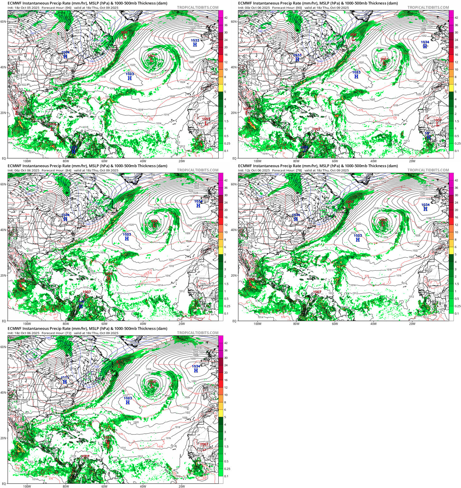
18z Euro peaks at 1001 mb: a nothingburger on paper, until you realize that it's the strongest the model had shown, after days of insisting that 95L won't develop.

Trend:

Image
1 likes   

User avatar
Teban54
Category 5
Category 5
Posts: 3521
Joined: Sat May 19, 2018 1:19 pm

Re: NATL: INVEST 95L - Models

#23 Postby Teban54 » Mon Oct 06, 2025 9:18 pm

Peak intensity on 18z hurricane models:
  • HWRF: 944 mb | 126 kt (Cat 4) | 93 hrs
  • HMON: 952 mb | 120 kt (Cat 4) | 75-78 hrs | Landfalls as a hurricane
  • HAFS-A: 982 mb | 64 kt (Cat 1) | 123-126 hrs | Landfalls as TS
  • HAFS-B: 987 mb | 82 kt (Cat 1) | 63 hrs | Landfalls as TS
It's strange how the HAFS models have been oscillating between Cat 4s (0z, 12z) and TSes or bare minimum hurricanes (6z, 18z). HAFS-A went from a 937 mb peak on the last run to 982 mb now!
1 likes   

LarryWx
S2K Supporter
S2K Supporter
Posts: 6744
Joined: Sun Sep 07, 2003 2:04 pm
Location: GA

Re: NATL: INVEST 95L - Models

#24 Postby LarryWx » Mon Oct 06, 2025 11:49 pm

0Z UKMET: much earlier TCG with TS Tue night; gets to close to Leewards while moving NW; recurves and goes SE of Bermuda as TS:

NEW TROPICAL CYCLONE FORECAST TO DEVELOP AFTER 30 HOURS
FORECAST POSITION AT T+ 30 : 13.6N 49.8W

LEAD CENTRAL MAXIMUM WIND
VERIFYING TIME TIME POSITION PRESSURE (MB) SPEED (KNOTS)
-------------- ---- -------- ------------- -------------
1200UTC 08.10.2025 36 14.1N 51.5W 1010 36
0000UTC 09.10.2025 48 15.6N 55.1W 1010 36
1200UTC 09.10.2025 60 17.3N 58.6W 1010 34
0000UTC 10.10.2025 72 19.1N 61.0W 1009 32
1200UTC 10.10.2025 84 21.8N 63.2W 1011 30
0000UTC 11.10.2025 96 24.7N 64.0W 1010 27
1200UTC 11.10.2025 108 28.7N 63.8W 1010 33
0000UTC 12.10.2025 120 31.9N 62.6W 1009 38
1200UTC 12.10.2025 132 33.9N 61.1W 1006 35
0000UTC 13.10.2025 144 35.6N 57.9W 1005 37
1200UTC 13.10.2025 156 36.6N 54.8W 1003 38
0000UTC 14.10.2025 168 35.9N 47.5W 1003 36
0 likes   
Personal Forecast Disclaimer:
The posts in this forum are NOT official forecasts and should not be used as such. They are just the opinion of the poster and may or may not be backed by sound meteorological data. They are NOT endorsed by any professional institution or storm2k.org. For official information, please refer to the NHC and NWS products.

User avatar
Teban54
Category 5
Category 5
Posts: 3521
Joined: Sat May 19, 2018 1:19 pm

Re: NATL: INVEST 95L - Models

#25 Postby Teban54 » Tue Oct 07, 2025 1:17 am

Peak intensity on 0z hurricane models:
  • HWRF: 930 mb | 135 kt (Cat 4) | 84-105 hrs | No landfall
  • HMON: 971 mb | 106 kt (Cat 3) | 57-60 hrs | Landfalls as TS
  • HAFS-A: 933 mb | 130 kt (Cat 4) | 108-111 hrs | Landfalls as hurricane
  • HAFS-B: 930 mb | 126 kt (Cat 4) | 120-126 hrs | Narrowly avoids landfall
The two HAFS models are back to showing Cat 4s, and HWRF also trended slightly stronger. HMON is the only one that became weaker than 18z. HAFS seems to suggest that the peak would be after the islands, not before.
1 likes   

User avatar
Kazmit
Category 5
Category 5
Posts: 2198
Age: 22
Joined: Mon Jul 25, 2016 8:49 am
Location: Bermuda

Re: NATL: INVEST 95L - Models

#26 Postby Kazmit » Tue Oct 07, 2025 6:09 am

I’m thinking the Euro dropped the ball on this one.
0 likes   
Igor 2010, Sandy 2012, Fay 2014, Gonzalo 2014, Joaquin 2015, Nicole 2016, Humberto 2019, Imelda 2025

I am only a tropical weather enthusiast. My predictions are not official and may or may not be backed by sound meteorological data. For official information, please refer to the NHC and NWS products.

User avatar
kevin
Category 5
Category 5
Posts: 2751
Age: 26
Joined: Wed Aug 28, 2019 4:35 am

Re: NATL: INVEST 95L - Models

#27 Postby kevin » Tue Oct 07, 2025 8:01 am

I wanted to a make a blend of the hurricane models again, but it's of no use. The 06z models are all over the place. A short summary then:

06z HWRF = TD at +3hr, TD at +6hr. Rapidly intensifies into a hurricane at +39hr and becomes a MH just 12 hours later. A big ACE-maker, recurves barely east of the islands but some might still have impacts. Peaks at 938 mb and 121 kt. A weakening recurving MH at the end of the run.
06z HMON = a TS at +3hr. Also rapidly intensifies into a hurricane at +36hr and peaks at 979mb/95kt at +54hr. But then it just falls apart within hours. Makes landfall on the islands and even briefly enters the ECar but as a weak 1000mb TS. Then recurves but never recovers. Ends the run on a recurve east of the Bahamas, barely as a TS/TD.
06z HAFS-A = a TS at +3hr. But afterwards takes a lot longer to get going. Makes landfall on the islands as a TS and then rapidly intensifies (exactly in the same region where HMON has 95L falling apart) into a hurricane at +90hr just east of Puerto Rico. Continues RI'ing the rest of the run and ends as an intensifying 931mb/116kt cat 4. Farther west than HWRF and HMON and might threaten Bermuda if the run would continue.
06z HAFS-B = a TS at +3hr. Similar to HAFS-A, makes landfall on the islands and doesn't really get going until then. Becomes a hurricane at +75hr while making landfall on the islands. Almost makes landfall as hurricane on Puerto Rico, but barely misses it to the east. Afterwards, similar story as HAFS-A, RI until the end of the run. Ends at 942mb/112kt and might be a threat for Bermuda.

So we have 'Short-term RI into a hurricane and MH and becoming a cat 4 ACE monster', 'Short-term RI into a hurricane and then randomly falling apart near the islands', 'Slower intensification and then sudden RI near the islands, becoming a cat 4 recurving monster'. Take your pick. One trend all the hurricane models have is that they show the most western paths of all the models.
1 likes   

User avatar
kevin
Category 5
Category 5
Posts: 2751
Age: 26
Joined: Wed Aug 28, 2019 4:35 am

Re: NATL: INVEST 95L - Models

#28 Postby kevin » Tue Oct 07, 2025 8:04 am

Most models show a recurve. But if the hurricane models are correct there could be TS/hurricane conditions on the islands within 72 hours. Hopefully the next 24 hours will bring more certainty.

Image
2 likes   

User avatar
aspen
Category 5
Category 5
Posts: 8917
Joined: Sat Oct 12, 2019 7:10 pm
Location: Connecticut, USA

Re: NATL: JERRY - Models

#29 Postby aspen » Tue Oct 07, 2025 1:21 pm

The HWRF’s first run of Jerry as a TC takes it right over Antigua/Barbuda as a Cat 4, and continues intensification down into the 920s north of the islands.

The hurricane models remain on the western side of the model guidance. If they verify, we could be looking at one of the most significant impacts to the Lesser Antilles in recent years. Fortunately, the OTS route is still wide open.
1 likes   
Irene '11 Sandy '12 Hermine '16 5/15/2018 Derecho Fay '20 Isaias '20 Elsa '21 Henri '21 Ida '21

I am only a meteorology enthusiast who knows a decent amount about tropical cyclones. Look to the professional mets, the NHC, or your local weather office for the best information.

MEANINGLESS_NUMBERS
Category 1
Category 1
Posts: 435
Joined: Mon Nov 02, 2020 1:43 pm

Re: NATL: JERRY - Models

#30 Postby MEANINGLESS_NUMBERS » Tue Oct 07, 2025 1:43 pm

Big spread in the models. Recon starts in earnest tomorrow. Hopefully that brings clarity
1 likes   
Emily '87, Felix '95, Gert '99, Fabian '03, Humberto '19, Paulette '20, Teddy '20, Fiona '22, Lee '23, Ernesto '24, Humberto/Imelda '25

User avatar
aspen
Category 5
Category 5
Posts: 8917
Joined: Sat Oct 12, 2019 7:10 pm
Location: Connecticut, USA

Re: NATL: JERRY - Models

#31 Postby aspen » Tue Oct 07, 2025 2:14 pm

I’m unable to post model run screenshots at the moment, but the 12z HWRF-P is showing a very scary setup for Jerry if it materializes. The storm gets stacked within 24-36 hours, and by Thursday afternoon/evening, it’s under a very favorable UL anticyclone while running over untapped ~29C SSTs. A favorable UL pattern remains into Saturday before a bit of shear begins to kick in. The ceiling could be quite high if this track and UL pattern materialize.
2 likes   
Irene '11 Sandy '12 Hermine '16 5/15/2018 Derecho Fay '20 Isaias '20 Elsa '21 Henri '21 Ida '21

I am only a meteorology enthusiast who knows a decent amount about tropical cyclones. Look to the professional mets, the NHC, or your local weather office for the best information.

User avatar
cycloneye
Admin
Admin
Posts: 147741
Age: 69
Joined: Thu Oct 10, 2002 10:54 am
Location: San Juan, Puerto Rico

Re: NATL: JERRY - Models

#32 Postby cycloneye » Tue Oct 07, 2025 2:40 pm

AI Google Deep Mind goes a little left thru the Leewards.

Image
0 likes   
Visit the Caribbean-Central America Weather Thread where you can find at first post web cams,radars
and observations from Caribbean basin members Click Here

TomballEd
Category 5
Category 5
Posts: 1025
Age: 61
Joined: Wed Aug 16, 2023 4:52 pm
Location: Spring/Klein area, not Tomball

Re: NATL: JERRY - Models

#33 Postby TomballEd » Tue Oct 07, 2025 2:41 pm

aspen wrote:I’m unable to post model run screenshots at the moment, but the 12z HWRF-P is showing a very scary setup for Jerry if it materializes. The storm gets stacked within 24-36 hours, and by Thursday afternoon/evening, it’s under a very favorable UL anticyclone while running over untapped ~29C SSTs. A favorable UL pattern remains into Saturday before a bit of shear begins to kick in. The ceiling could be quite high if this track and UL pattern materialize.


Image
0 likes   

User avatar
AnnularCane
S2K Supporter
S2K Supporter
Posts: 2934
Joined: Thu Jun 08, 2006 9:18 am
Location: Wytheville, VA

Re: NATL: JERRY - Models

#34 Postby AnnularCane » Tue Oct 07, 2025 2:52 pm

It's not Jerry that that setup would be scary for. :eek:
0 likes   
"But it never rained rain. It never snowed snow. And it never blew just wind. It rained things like soup and juice. It snowed mashed potatoes and green peas. And sometimes the wind blew in storms of hamburgers." -- Judi Barrett, Cloudy with a Chance of Meatballs

MEANINGLESS_NUMBERS
Category 1
Category 1
Posts: 435
Joined: Mon Nov 02, 2020 1:43 pm

Re: NATL: JERRY - Models

#35 Postby MEANINGLESS_NUMBERS » Tue Oct 07, 2025 3:26 pm

TomballEd wrote:
aspen wrote:I’m unable to post model run screenshots at the moment, but the 12z HWRF-P is showing a very scary setup for Jerry if it materializes. The storm gets stacked within 24-36 hours, and by Thursday afternoon/evening, it’s under a very favorable UL anticyclone while running over untapped ~29C SSTs. A favorable UL pattern remains into Saturday before a bit of shear begins to kick in. The ceiling could be quite high if this track and UL pattern materialize.


https://i.imgur.com/iXgaj6E.png


Is that Barbuda landfall?
0 likes   
Emily '87, Felix '95, Gert '99, Fabian '03, Humberto '19, Paulette '20, Teddy '20, Fiona '22, Lee '23, Ernesto '24, Humberto/Imelda '25

TomballEd
Category 5
Category 5
Posts: 1025
Age: 61
Joined: Wed Aug 16, 2023 4:52 pm
Location: Spring/Klein area, not Tomball

Re: NATL: JERRY - Models

#36 Postby TomballEd » Tue Oct 07, 2025 6:02 pm

MEANINGLESS_NUMBERS wrote:
TomballEd wrote:
aspen wrote:I’m unable to post model run screenshots at the moment, but the 12z HWRF-P is showing a very scary setup for Jerry if it materializes. The storm gets stacked within 24-36 hours, and by Thursday afternoon/evening, it’s under a very favorable UL anticyclone while running over untapped ~29C SSTs. A favorable UL pattern remains into Saturday before a bit of shear begins to kick in. The ceiling could be quite high if this track and UL pattern materialize.


https://i.imgur.com/iXgaj6E.png


Is that Barbuda landfall?


That or Antigua. I don't have my Lesser Antilles memorized. I can always spot Barbados and Guadeloupe.
0 likes   

User avatar
AJC3
Admin
Admin
Posts: 4105
Age: 61
Joined: Tue Aug 31, 2004 7:04 pm
Location: Ballston Spa, New York
Contact:

Re: NATL: JERRY - Models

#37 Postby AJC3 » Tue Oct 07, 2025 6:54 pm

TomballEd wrote:
MEANINGLESS_NUMBERS wrote:


Is that Barbuda landfall?


That or Antigua. I don't have my Lesser Antilles memorized. I can always spot Barbados and Guadeloupe.


It's Barbuda. Antigua is the island just to the south. I always found it amusing how St. Kitts looks like a chicken wing (drumette) and Guadeloupe looks like a butterflied pork chop. lol
2 likes   

User avatar
AnnularCane
S2K Supporter
S2K Supporter
Posts: 2934
Joined: Thu Jun 08, 2006 9:18 am
Location: Wytheville, VA

Re: NATL: JERRY - Models

#38 Postby AnnularCane » Tue Oct 07, 2025 7:00 pm

AJC3 wrote:
TomballEd wrote:
MEANINGLESS_NUMBERS wrote:
Is that Barbuda landfall?


That or Antigua. I don't have my Lesser Antilles memorized. I can always spot Barbados and Guadeloupe.


It's Barbuda. Antigua is the island just to the south. I always found it amusing how St. Kitts looks like a chicken wing (drumette) and Guadeloupe looks like a butterflied pork chop. lol


And Nevis is a chicken nugget. :lol:
2 likes   
"But it never rained rain. It never snowed snow. And it never blew just wind. It rained things like soup and juice. It snowed mashed potatoes and green peas. And sometimes the wind blew in storms of hamburgers." -- Judi Barrett, Cloudy with a Chance of Meatballs

MEANINGLESS_NUMBERS
Category 1
Category 1
Posts: 435
Joined: Mon Nov 02, 2020 1:43 pm

Re: NATL: JERRY - Models

#39 Postby MEANINGLESS_NUMBERS » Wed Oct 08, 2025 10:58 am

12z model mean hasn't moved much through 72 hours, but tighter clustering means less threat of landfall in the NE Caribbean. Big eastward shift at the end of the model runs keeps it well east of Bermuda too.
1 likes   
Emily '87, Felix '95, Gert '99, Fabian '03, Humberto '19, Paulette '20, Teddy '20, Fiona '22, Lee '23, Ernesto '24, Humberto/Imelda '25

User avatar
Teban54
Category 5
Category 5
Posts: 3521
Joined: Sat May 19, 2018 1:19 pm

Re: NATL: JERRY - Models

#40 Postby Teban54 » Wed Oct 08, 2025 11:59 pm

:lol: :lol: :lol:

The 18 UTC GFS, and the hurricane-regional models based
on the GFS, all show very little change in strength and even
dissipate Jerry in the 72-96 h time frame. However, a glance at the
short-term model forecast shows the GFS is struggling to correctly
depict the convective structure of Jerry. To make matters more
confusing, the last several ECMWF runs now show a much stronger
Jerry in the 48-96 h time frame, with the 18 UTC run showing a
strengthening hurricane with pressure below 960 mb.
0 likes   


Return to “Active Storms/Invests - Atlantic/EastPAC/CentralPAC/MED”

Who is online

Users browsing this forum: No registered users and 89 guests