NATL: JERRY - Tropical Storm - Discussion

Current storms and invests:

Moderators: hurricanetrack, S2k Moderators


The posts in this forum are NOT official forecasts and should not be used as such. They are just the opinion of the poster and may or may not be backed by sound meteorological data. They are NOT endorsed by any professional institution or STORM2K. For official information, please refer to products from the National Hurricane Center and National Weather Service.

Help Support Storm2K
Message
Author
zzzh
Category 4
Category 4
Posts: 938
Joined: Thu Sep 02, 2021 1:13 pm

Re: NATL: JERRY - Tropical Storm - Discussion

#121 Postby zzzh » Wed Oct 08, 2025 9:14 pm

Image
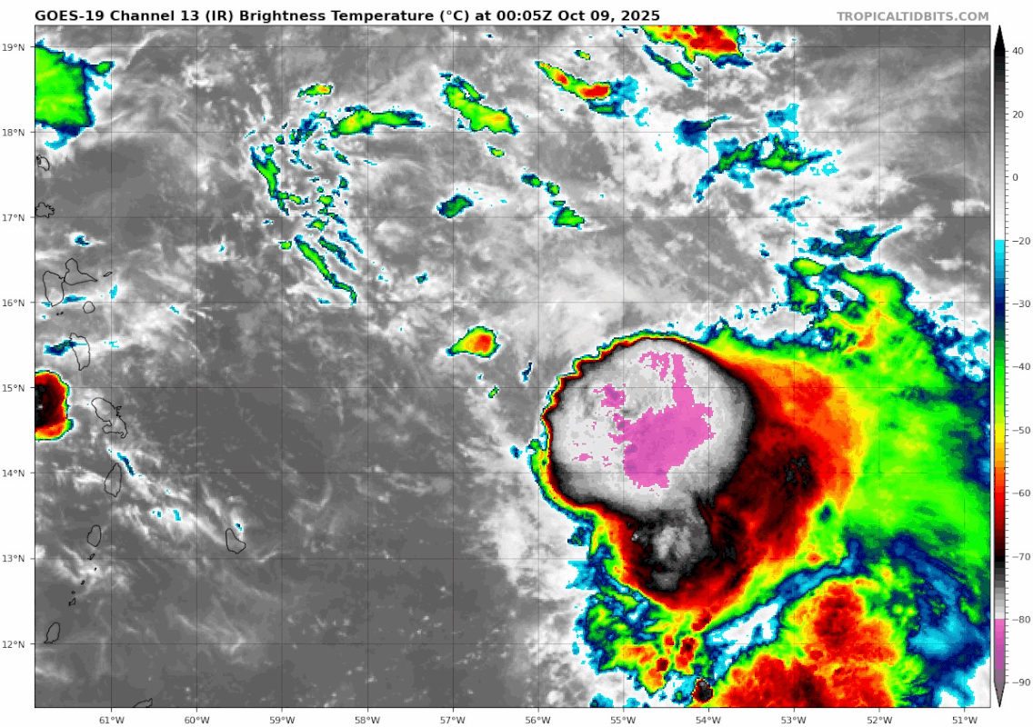
The center just reformed under the convection. The original center went from 1000mb to 1006mb so the new center will soon take full control.
1 likes   

zhukm29
Category 1
Category 1
Posts: 347
Joined: Tue Aug 28, 2018 2:37 pm

Re: NATL: JERRY - Tropical Storm - Discussion

#122 Postby zhukm29 » Thu Oct 09, 2025 12:11 am

Image
0 likes   

User avatar
Hammy
Category 5
Category 5
Posts: 5864
Age: 42
Joined: Fri May 25, 2012 5:25 pm
Contact:

Re: NATL: JERRY - Tropical Storm - Discussion

#123 Postby Hammy » Thu Oct 09, 2025 12:28 am

Image

Seems like there might be multiple centers
0 likes   
The above post is not official and should not be used as such. It is the opinion of the poster and may or may not be backed by sound meteorological data. It is not endorsed by any professional institution or storm2k.org. For official information, please refer to the NHC and NWS products.

Sciencerocks
Category 5
Category 5
Posts: 9781
Age: 39
Joined: Thu Jul 06, 2017 1:51 am

Re: NATL: JERRY - Tropical Storm - Discussion

#124 Postby Sciencerocks » Thu Oct 09, 2025 2:54 am

Image
0 likes   

MEANINGLESS_NUMBERS
Category 1
Category 1
Posts: 435
Joined: Mon Nov 02, 2020 1:43 pm

Re: NATL: JERRY - Tropical Storm - Discussion

#125 Postby MEANINGLESS_NUMBERS » Thu Oct 09, 2025 4:17 am

Is it my imagination or does it look like the LLC’a forward motion has slowed?
0 likes   
Emily '87, Felix '95, Gert '99, Fabian '03, Humberto '19, Paulette '20, Teddy '20, Fiona '22, Lee '23, Ernesto '24, Humberto/Imelda '25

User avatar
wxman57
Moderator-Pro Met
Moderator-Pro Met
Posts: 23068
Age: 68
Joined: Sat Jun 21, 2003 8:06 pm
Location: Houston, TX (southwest)

Re: NATL: JERRY - Tropical Storm - Discussion

#126 Postby wxman57 » Thu Oct 09, 2025 6:28 am

Jerry is a sheared mess this morning. Some of those squalls will likely clip the NE Caribbean islands tonight. Don't know if they'll reach as far west as St. Croix or the BVI, though.
2 likes   

User avatar
wxman57
Moderator-Pro Met
Moderator-Pro Met
Posts: 23068
Age: 68
Joined: Sat Jun 21, 2003 8:06 pm
Location: Houston, TX (southwest)

Re: NATL: JERRY - Tropical Storm - Discussion

#127 Postby wxman57 » Thu Oct 09, 2025 8:37 am

My coworker thinks recon shows Jerry has no circulation. It's very poorly organized, that's for sure.
0 likes   

LarryWx
S2K Supporter
S2K Supporter
Posts: 6744
Joined: Sun Sep 07, 2003 2:04 pm
Location: GA

Re: NATL: JERRY - Tropical Storm - Discussion

#128 Postby LarryWx » Thu Oct 09, 2025 10:02 am

wxman57 wrote:My coworker thinks recon shows Jerry has no circulation. It's very poorly organized, that's for sure.


Tropical Storm Jerry Discussion Number 9
NWS National Hurricane Center Miami FL AL102025
1100 AM AST Thu Oct 09 2025

The NOAA and Air Force Hurricane Hunters have been investigating
Jerry this morning, and the radar and flight-level wind data show
that the storm remains lopsided with nearly all of the strong winds
and convection on the system's east side. The center itself has
been difficult to fix, but the data generally support a position
that is located south-southeast of the previous track. The initial
intensity is held at 55 kt based on a combination of the aircraft
data and satellite estimates.
0 likes   
Personal Forecast Disclaimer:
The posts in this forum are NOT official forecasts and should not be used as such. They are just the opinion of the poster and may or may not be backed by sound meteorological data. They are NOT endorsed by any professional institution or storm2k.org. For official information, please refer to the NHC and NWS products.

User avatar
WaveBreaking
Category 2
Category 2
Posts: 627
Joined: Sun Jun 30, 2024 11:33 am
Location: US

Re: NATL: JERRY - Tropical Storm - Discussion

#129 Postby WaveBreaking » Thu Oct 09, 2025 10:21 am

Jerry might be undergoing a center relocation this morning since its LLC is elongated NW-SE

Image

Image
4 likes   
I am NOT a professional meteorologist, so take all of my posts with a grain of salt. My opinions are mine and mine alone.

hipshot
Category 2
Category 2
Posts: 602
Joined: Tue Jul 06, 2010 9:18 pm
Location: Dallas, Texas

Re: NATL: JERRY - Tropical Storm - Discussion

#130 Postby hipshot » Thu Oct 09, 2025 1:09 pm

WaveBreaking wrote:Jerry might be undergoing a center relocation this morning since its LLC is elongated NW-SE

https://i.imgur.com/z16Oudn.gif

https://i.imgur.com/twMC26A.jpeg


If Jerry is going to slide by to the north east, it had better hurry because it doesn't look like from this satellite view.
0 likes   

User avatar
cycloneye
Admin
Admin
Posts: 147741
Age: 69
Joined: Thu Oct 10, 2002 10:54 am
Location: San Juan, Puerto Rico

Re: NATL: JERRY - Tropical Storm - Discussion

#131 Postby cycloneye » Thu Oct 09, 2025 1:58 pm

Starting to make the turn to NW.

AL, 10, 2025 BEST, 0, 168N, 601W, 55, 1001, TS


Image
2 likes   
Visit the Caribbean-Central America Weather Thread where you can find at first post web cams,radars
and observations from Caribbean basin members Click Here

Sciencerocks
Category 5
Category 5
Posts: 9781
Age: 39
Joined: Thu Jul 06, 2017 1:51 am

Re: NATL: JERRY - Tropical Storm - Discussion

#132 Postby Sciencerocks » Thu Oct 09, 2025 2:49 pm

Image
1 likes   

User avatar
Woofde
Category 2
Category 2
Posts: 537
Joined: Tue Jul 06, 2021 11:33 am

Re: RE: Re: NATL: JERRY - Tropical Storm - Discussion

#133 Postby Woofde » Thu Oct 09, 2025 2:57 pm

Sciencerocks wrote:Image
It doesn't look it on satellite, but Jerry is starting to enter a lesser area of shear now. It's riding a fine line.Image
0 likes   

User avatar
msbee
S2K Supporter
S2K Supporter
Posts: 3042
Joined: Wed Jun 11, 2003 10:11 am
Location: St. Maarten

Re: NATL: JERRY - Tropical Storm - Discussion

#134 Postby msbee » Thu Oct 09, 2025 3:10 pm

Image
3 likes   
Too many hurricanes to remember

User avatar
Blown Away
S2K Supporter
S2K Supporter
Posts: 10204
Joined: Wed May 26, 2004 6:17 am

Re: NATL: JERRY - Tropical Storm - Discussion

#135 Postby Blown Away » Thu Oct 09, 2025 3:27 pm

1 likes   
Hurricane Eye Experience: David 79, Irene 99, Frances 04, Jeanne 04, Wilma 05… Hurricane Brush Experience: Andrew 92, Erin 95, Floyd 99, Matthew 16, Irma 17, Ian 22, Nicole 22…

User avatar
cycloneye
Admin
Admin
Posts: 147741
Age: 69
Joined: Thu Oct 10, 2002 10:54 am
Location: San Juan, Puerto Rico

Re: NATL: JERRY - Tropical Storm - Discussion

#136 Postby cycloneye » Thu Oct 09, 2025 3:29 pm

1 likes   
Visit the Caribbean-Central America Weather Thread where you can find at first post web cams,radars
and observations from Caribbean basin members Click Here

Sciencerocks
Category 5
Category 5
Posts: 9781
Age: 39
Joined: Thu Jul 06, 2017 1:51 am

Re: NATL: JERRY - Tropical Storm - Discussion

#137 Postby Sciencerocks » Thu Oct 09, 2025 5:02 pm

Image
1 likes   

Sciencerocks
Category 5
Category 5
Posts: 9781
Age: 39
Joined: Thu Jul 06, 2017 1:51 am

Re: NATL: JERRY - Tropical Storm - Discussion

#138 Postby Sciencerocks » Thu Oct 09, 2025 6:47 pm

Image
0 likes   

User avatar
Nimbus
Category 5
Category 5
Posts: 5385
Joined: Mon Jul 19, 2004 10:54 am

Re: NATL: JERRY - Tropical Storm - Discussion

#139 Postby Nimbus » Thu Oct 09, 2025 6:59 pm

The center is near Codrington with peak wind gusts expected near 25 MPH and an inch or two of rain.
You can get tropical storm wind gusts in severe thunderstorms but usually not so much on the weak side of the storm.
0 likes   

LarryWx
S2K Supporter
S2K Supporter
Posts: 6744
Joined: Sun Sep 07, 2003 2:04 pm
Location: GA

Re: NATL: JERRY - Tropical Storm - Discussion

#140 Postby LarryWx » Thu Oct 09, 2025 7:54 pm

The lowest SLP is now up to 1007 mb?!?

VORTEX DATA MESSAGE AL102025
A. 09/23:27:20Z
B. 17.47 deg N 061.06 deg W
C. 850 mb 1486 m
D. 1007 mb
E. 240 deg 10 kt
F. NA
G. NA
H. 11 kt
I. 225 deg 35 nm 23:17:00Z
J. 277 deg 20 kt
K. 226 deg 59 nm 23:10:00Z
L. 43 kt
M. 047 deg 61 nm 23:45:30Z
N. 149 deg 56 kt
O. 047 deg 58 nm 23:44:30Z
P. 18 C / 1525 m
Q. 20 C / 1524 m
R. 14 C / NA
S. 1345 / 8
T. 0.02 / 7 nm
U. AF306 0610A JERRY OB 03
MAX FL WIND 56 KT 047 / 58 NM 23:44:30Z
0 likes   
Personal Forecast Disclaimer:
The posts in this forum are NOT official forecasts and should not be used as such. They are just the opinion of the poster and may or may not be backed by sound meteorological data. They are NOT endorsed by any professional institution or storm2k.org. For official information, please refer to the NHC and NWS products.


Return to “Active Storms/Invests - Atlantic/EastPAC/CentralPAC/MED”

Who is online

Users browsing this forum: No registered users and 89 guests