NATL: LORENZO - Tropcial Strom - Discussion

Current storms and invests:

Moderators: hurricanetrack, S2k Moderators


The posts in this forum are NOT official forecasts and should not be used as such. They are just the opinion of the poster and may or may not be backed by sound meteorological data. They are NOT endorsed by any professional institution or STORM2K. For official information, please refer to products from the National Hurricane Center and National Weather Service.

Help Support Storm2K
Message
Author
Subtrop
Category 2
Category 2
Posts: 705
Joined: Sun Feb 21, 2021 9:45 pm

NATL: LORENZO - Tropcial Strom - Discussion

#1 Postby Subtrop » Sat Oct 11, 2025 8:35 pm

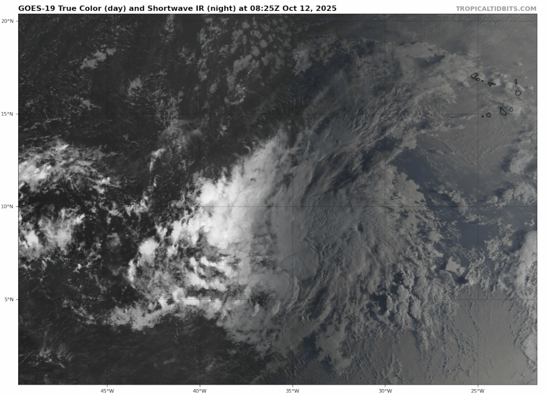
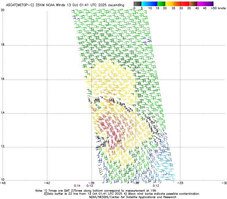
AL, 97, 2025101200, , BEST, 0, 81N, 317W, 25, 1008, DB, 34, NEQ, 0, 0, 0, 0, 1011, 150, 90, 0, 0, L, 0, , 0, 0, INVEST, S, 0, , 0, 0, 0, 0, genesis-num, 034, SPAWNINVEST, al762025 to al972025,

https://ftp.nhc.noaa.gov/atcf/btk/bal972025.dat
Last edited by Subtrop on Mon Oct 13, 2025 3:16 am, edited 1 time in total.
1 likes   

User avatar
Category5Kaiju
Category 5
Category 5
Posts: 4218
Joined: Thu Dec 24, 2020 12:45 pm
Location: Seattle

Re: NATL: INVEST 97L - Discussion (30/50)

#2 Postby Category5Kaiju » Sat Oct 11, 2025 9:00 pm

Maybe not as strong, but it does look like this will end up as a Lorenzo with a very similar track to the 2019 version of the same name.
3 likes   
Unless explicitly stated, all info in my posts is based on my own opinions and observations. Tropical storms and hurricanes can be extremely dangerous. Do not think you can beat Mother Nature. Refer to an accredited weather research agency or meteorologist if you need to make serious decisions regarding an approaching storm.

User avatar
ScottNAtlanta
Category 5
Category 5
Posts: 2470
Joined: Sat May 25, 2013 3:11 pm
Location: Atlanta, GA

Re: NATL: INVEST 97L - Discussion (30/50)

#3 Postby ScottNAtlanta » Sat Oct 11, 2025 10:03 pm

Looks like the first model runs show this making a loop back to the west after it goes north
0 likes   
The posts in this forum are NOT official forecast and should not be used as such. They are just the opinion of the poster and may or may not be backed by sound meteorological data. They are NOT endorsed by any professional institution or storm2k.org. For official information, please refer to the NHC and NWS products.

Sciencerocks
Category 5
Category 5
Posts: 9785
Age: 39
Joined: Thu Jul 06, 2017 1:51 am

Re: NATL: INVEST 97L - Discussion (30/50)

#4 Postby Sciencerocks » Sun Oct 12, 2025 12:06 am

Image
1 likes   

User avatar
AJC3
Admin
Admin
Posts: 4107
Age: 61
Joined: Tue Aug 31, 2004 7:04 pm
Location: Ballston Spa, New York
Contact:

Re: NATL: INVEST 97L - Discussion (40/50)

#5 Postby AJC3 » Sun Oct 12, 2025 1:58 am

Tropical Weather Outlook
NWS National Hurricane Center Miami FL
200 AM EDT Sun Oct 12 2025


Eastern and Central Tropical Atlantic (AL97):
A tropical wave located well to the southwest of the Cabo Verde
Islands continues to produce a large area of disorganized showers
and thunderstorms. Environmental conditions appear conducive for
some development of this system during the next few days, and a
tropical depression could form during the early or middle part of
this week while it moves to the west-northwest or northwest at 15 to
20 mph across the central tropical Atlantic.
* Formation chance through 48 hours...medium...40 percent.
* Formation chance through 7 days...medium...50 percent.
0 likes   

User avatar
cycloneye
Admin
Admin
Posts: 147768
Age: 69
Joined: Thu Oct 10, 2002 10:54 am
Location: San Juan, Puerto Rico

Re: NATL: INVEST 97L - Discussion (40/50)

#6 Postby cycloneye » Sun Oct 12, 2025 6:42 am

Tropical Weather Outlook
NWS National Hurricane Center Miami FL
800 AM EDT Sun Oct 12 2025


Eastern and Central Tropical Atlantic (AL97):
A tropical wave located well to the southwest of the Cabo Verde
Islands continues to produce a large area of disorganized showers
and thunderstorms. Environmental conditions appear conducive for
some development of this system during the next few days, and a
tropical depression could form during the early or middle part of
this week while it moves to the west-northwest or northwest at 15 to
20 mph across the central tropical Atlantic.
* Formation chance through 48 hours...medium...40 percent.
* Formation chance through 7 days...medium...50 percent.
0 likes   
Visit the Caribbean-Central America Weather Thread where you can find at first post web cams,radars
and observations from Caribbean basin members Click Here

User avatar
Teban54
Category 5
Category 5
Posts: 3526
Joined: Sat May 19, 2018 1:19 pm

Re: NATL: INVEST 97L - Discussion (40/50)

#7 Postby Teban54 » Sun Oct 12, 2025 8:30 am

Image
1 likes   

Sciencerocks
Category 5
Category 5
Posts: 9785
Age: 39
Joined: Thu Jul 06, 2017 1:51 am

Re: NATL: INVEST 97L - Discussion (40/50)

#8 Postby Sciencerocks » Sun Oct 12, 2025 12:03 pm

Image
0 likes   

User avatar
cycloneye
Admin
Admin
Posts: 147768
Age: 69
Joined: Thu Oct 10, 2002 10:54 am
Location: San Juan, Puerto Rico

Re: NATL: INVEST 97L - Discussion (40/50)

#9 Postby cycloneye » Sun Oct 12, 2025 12:31 pm

Tropical Weather Outlook
NWS National Hurricane Center Miami FL
200 PM EDT Sun Oct 12 2025


Central Tropical Atlantic (AL97):
An area of low pressure located well west-southwest of the Cabo
Verde Islands continues to produce a large area of disorganized
showers and thunderstorms. Environmental conditions appear conducive
for some development of this system during the next few days, and a
tropical depression could form during the early or middle part of
this week while it moves to the west-northwest or northwest at 15 to
20 mph across the central tropical Atlantic.
* Formation chance through 48 hours...medium...40 percent.
* Formation chance through 7 days...medium...50 percent.
0 likes   
Visit the Caribbean-Central America Weather Thread where you can find at first post web cams,radars
and observations from Caribbean basin members Click Here

TomballEd
Category 5
Category 5
Posts: 1031
Age: 61
Joined: Wed Aug 16, 2023 4:52 pm
Location: Spring/Klein area, not Tomball

Re: NATL: INVEST 97L - Discussion (40/50)

#10 Postby TomballEd » Sun Oct 12, 2025 3:10 pm

Looked better yesterday.
0 likes   

Sciencerocks
Category 5
Category 5
Posts: 9785
Age: 39
Joined: Thu Jul 06, 2017 1:51 am

Re: NATL: INVEST 97L - Discussion (40/50)

#11 Postby Sciencerocks » Sun Oct 12, 2025 3:22 pm

TomballEd wrote:Looked better yesterday.


True, but it certainly has a well defined LLC exposed with 20-25 knots of south-southwesterly shear. Until this decreases I don't expect it to be able to stack convection over the LLC. So probably a sheared mess until it exits the MDR and moves above 20. This is pretty much what intensity models show..

I
0 likes   

User avatar
cycloneye
Admin
Admin
Posts: 147768
Age: 69
Joined: Thu Oct 10, 2002 10:54 am
Location: San Juan, Puerto Rico

Re: NATL: INVEST 97L - Discussion (60/70)

#12 Postby cycloneye » Sun Oct 12, 2025 6:37 pm

Tropical Weather Outlook
NWS National Hurricane Center Miami FL
800 PM EDT Sun Oct 12 2025


Central Tropical Atlantic (AL97):
Showers and thunderstorms have increased in association with a
small area of low pressure located about 900 miles west-southwest of
the Cabo Verde Islands. Environmental conditions are forecast to
become more favorable for further development of this system during
the next few days, and a tropical depression is likely to form by
the middle part of this week while it moves to the west-northwest
then northwest at 15 to 20 mph across the central tropical Atlantic.
* Formation chance through 48 hours...medium...60 percent.
* Formation chance through 7 days...high...70 percent.
1 likes   
Visit the Caribbean-Central America Weather Thread where you can find at first post web cams,radars
and observations from Caribbean basin members Click Here

zhukm29
Category 1
Category 1
Posts: 353
Joined: Tue Aug 28, 2018 2:37 pm

Re: NATL: INVEST 97L - Discussion (60/70)

#13 Postby zhukm29 » Sun Oct 12, 2025 9:02 pm

Has gales, looks close now to becoming a tropical storm.
Image
1 likes   

User avatar
galaxy401
Category 5
Category 5
Posts: 2431
Age: 30
Joined: Sat Aug 25, 2012 9:04 pm
Location: Casa Grande, Arizona

Re: NATL: INVEST 97L - Discussion (70/80)

#14 Postby galaxy401 » Mon Oct 13, 2025 1:24 am

Up to 70/80.

Tropical Weather Outlook
NWS National Hurricane Center Miami FL
200 AM EDT Mon Oct 13 2025


Central Tropical Atlantic (AL97):
Showers and thunderstorms continue to increase near and just east of
a small area of low pressure located more than 900 miles west of the
Cabo Verde Islands. In addition, recent satellite wind data
indicates the system is also producing tropical-storm force winds,
primarily to the east of its center. Environmental conditions are
forecast to become more favorable for further development over the
next couple of days and a tropical storm is likely to form by the
early to middle portion of this week as the system moves
west-northwest to northwest at 15 to 20 mph across the central
tropical Atlantic. For more information on this system, including
gale warnings, please see High Seas Forecasts issued by the National
Weather Service.
* Formation chance through 48 hours...high...70 percent.
* Formation chance through 7 days...high...80 percent.
1 likes   
Got my eyes on moving right into Hurricane Alley: Florida.

Subtrop
Category 2
Category 2
Posts: 705
Joined: Sun Feb 21, 2021 9:45 pm

Re: NATL: LORENZO - Tropcial Strom - Discussion

#15 Postby Subtrop » Mon Oct 13, 2025 2:53 am

AL, 12, 2025101306, , BEST, 0, 138N, 396W, 40, 1006, TS, 34, NEQ, 80, 0, 0, 0, 1010, 140, 50, 0, 0, L, 0, , 0, 0, LORENZO, S, 0, , 0, 0, 0, 0, genesis-num, 034, TRANSITIONED, alB72025 to al122025,
1 likes   

Subtrop
Category 2
Category 2
Posts: 705
Joined: Sun Feb 21, 2021 9:45 pm

Re: NATL: LORENZO - Tropcial Strom - Discussion

#16 Postby Subtrop » Mon Oct 13, 2025 3:16 am

1 likes   

User avatar
abajan
S2K Supporter
S2K Supporter
Posts: 4293
Age: 61
Joined: Sun Sep 07, 2003 5:10 am
Location: Barbados

Re: NATL: LORENZO - Tropcial Strom - Discussion

#17 Postby abajan » Mon Oct 13, 2025 3:58 am

Subtrop wrote:
AL, 12, 2025101306, , BEST, 0, 138N, 396W, 40, 1006, TS, 34, NEQ, 80, 0, 0, 0, 1010, 140, 50, 0, 0, L, 0, , 0, 0, LORENZO, S, 0, , 0, 0, 0, 0, genesis-num, 034, TRANSITIONED, alB72025 to al122025,

Whence did you get this info? The site I check is https://ftp.nhc.noaa.gov/atcf/btk/ but its info isn't as up-to-date as I would like.
0 likes   

User avatar
AJC3
Admin
Admin
Posts: 4107
Age: 61
Joined: Tue Aug 31, 2004 7:04 pm
Location: Ballston Spa, New York
Contact:

Re: NATL: LORENZO - Tropcial Strom - Discussion

#18 Postby AJC3 » Mon Oct 13, 2025 4:53 am

abajan wrote:
Subtrop wrote:
AL, 12, 2025101306, , BEST, 0, 138N, 396W, 40, 1006, TS, 34, NEQ, 80, 0, 0, 0, 1010, 140, 50, 0, 0, L, 0, , 0, 0, LORENZO, S, 0, , 0, 0, 0, 0, genesis-num, 034, TRANSITIONED, alB72025 to al122025,

Whence did you get this info? The site I check is https://ftp.nhc.noaa.gov/atcf/btk/ but its info isn't as up-to-date as I would like.


It was eventually updated when I checked after 5 AM.
0 likes   

User avatar
cycloneye
Admin
Admin
Posts: 147768
Age: 69
Joined: Thu Oct 10, 2002 10:54 am
Location: San Juan, Puerto Rico

Re: NATL: LORENZO - Tropcial Strom - Discussion

#19 Postby cycloneye » Mon Oct 13, 2025 7:17 am

Looking good. Teban54, it may get a few ACE points and the NATL pass the 100 mark and add a few more after that number.

Image
0 likes   
Visit the Caribbean-Central America Weather Thread where you can find at first post web cams,radars
and observations from Caribbean basin members Click Here


Return to “Active Storms/Invests - Atlantic/EastPAC/CentralPAC/MED”

Who is online

Users browsing this forum: No registered users and 59 guests