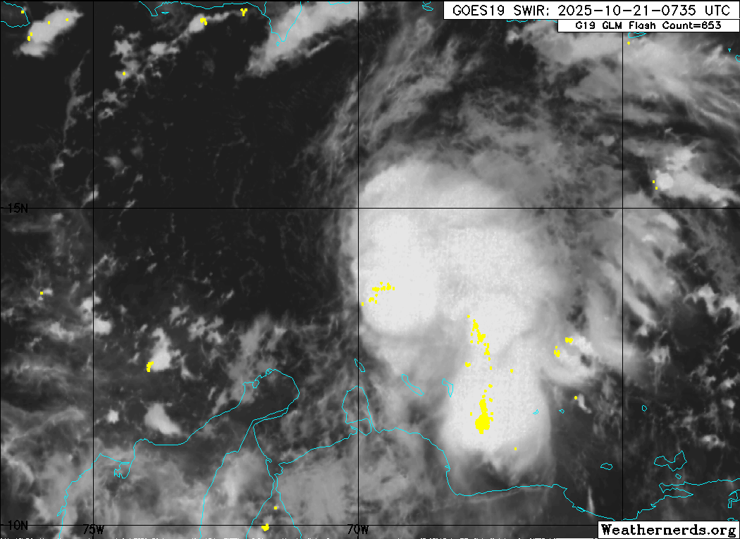
NATL: MELISSA - Tropical Storm - Discussion

Current storms and invests:

Moderators: hurricanetrack, S2k Moderators


The posts in this forum are NOT official forecasts and should not be used as such. They are just the opinion of the poster and may or may not be backed by sound meteorological data. They are NOT endorsed by any professional institution or STORM2K. For official information, please refer to products from the National Hurricane Center and National Weather Service.

Help Support Storm2K
Message
Author
User avatar
Hurricane2022
Category 5
Category 5
Posts: 1761
Joined: Tue Aug 23, 2022 11:38 pm
Location: Araçatuba, Brazil

Re: NATL: INVEST 98L - Discussion (90/90)

#101 Postby Hurricane2022 » Tue Oct 21, 2025 4:08 am

abajan wrote:6z Best Track:
AL, 98, 2025102106, , BEST, 0, 140N, 698W, 40, 1004, DB

This seems to be somewhat ahead of expectations. It appears that we may indeed be facing a strong Hurricane Melissa slowly approaching Hispaniola. That would be a major victory for the GFS, but at the same time, a historic catastrophe for Haiti and the Dominican Republic. But let's just wait and see what happens next.
2 likes   
Sorry for the bad English sometimes...!
For reliable and detailed information for any meteorological phenomenon, please consult the National Hurricane Center, Joint Typhoon Warning Center , or your local Meteo Center.

--------

Una cvm Christo, pro Christo, et in Christo. Sit nomen Domini benedictvm.

User avatar
cycloneye
Admin
Admin
Posts: 147942
Age: 69
Joined: Thu Oct 10, 2002 10:54 am
Location: San Juan, Puerto Rico

Re: NATL: INVEST 98L - Discussion (90/90)

#102 Postby cycloneye » Tue Oct 21, 2025 4:09 am

I think Melissa may be introduced before the plane goes this afternoon. Looks like a closed circulation on the edge of convection. First visible will do the trigger.

Image
5 likes   
Visit the Caribbean-Central America Weather Thread where you can find at first post web cams,radars
and observations from Caribbean basin members Click Here

User avatar
kevin
Category 5
Category 5
Posts: 2781
Age: 27
Joined: Wed Aug 28, 2019 4:35 am

Re: NATL: INVEST 98L - Discussion (90/90)

#103 Postby kevin » Tue Oct 21, 2025 4:25 am

Virtually absent dry air as well as a very warm region with an MPI below 900mb and above 170kt. Shear is still very high and I honestly expected it to keep 98L in check for a while, but it seems to be doing quite well so who knows.
1 likes   

User avatar
cycloneye
Admin
Admin
Posts: 147942
Age: 69
Joined: Thu Oct 10, 2002 10:54 am
Location: San Juan, Puerto Rico

Re: NATL: INVEST 98L - Discussion (90/90)

#104 Postby cycloneye » Tue Oct 21, 2025 4:44 am

0 likes   
Visit the Caribbean-Central America Weather Thread where you can find at first post web cams,radars
and observations from Caribbean basin members Click Here

User avatar
tropicwatch
Category 5
Category 5
Posts: 3423
Age: 61
Joined: Sat Jun 02, 2007 10:01 am
Location: Panama City Florida
Contact:

Re: NATL: INVEST 98L - Discussion (90/90)

#105 Postby tropicwatch » Tue Oct 21, 2025 5:44 am

0 likes   
Tropicwatch


Agnes 72', Eloise 75, Elena 85', Kate 85', Charley 86', Florence 88', Beryl 94', Dean 95', Erin 95', Opal 95', Earl 98', Georges 98', Ivan 2004', Arlene 2005', Dennis 2005', Ida 2009' Debby 2012' Irma 2017' Michael 2018'

User avatar
GCANE
S2K Supporter
S2K Supporter
Posts: 11825
Joined: Mon Oct 22, 2007 8:03 am

Re: NATL: INVEST 98L - Discussion (90/90)

#106 Postby GCANE » Tue Oct 21, 2025 5:53 am

Obviously, a very strong west to east jet is hitting this and GFS is completely ignoring it.
Constant convection indicates a very strong wave or perhaps closed circulation,
IMHO, can pretty much throw out what the models are forecasting at this point.
1 likes   

BobHarlem
Category 5
Category 5
Posts: 2522
Joined: Thu Oct 20, 2005 6:11 pm

Re: NATL: INVEST 98L - Discussion (90/90)

#107 Postby BobHarlem » Tue Oct 21, 2025 5:54 am

tropicwatch wrote:98L appears to have a surface circulation this morning.

https://earth.nullschool.net/#current/wind/surface/level/orthographic=-72.43,13.45,3803


Still elongated axis sw (From around Siapana in Venezuela) to the north where the top curve is, but it looks like it'll develop in a bit -- it's on it's way. It'll be a judgement call to do so before recon. (Personally I'd wait for recon because of how sensitive to details the models are right now). West of the Lightning cluster area north of Aruba is likely where it'll wind up though. Models do not have a great grasp of the setup right now. Even with development you may have an exposed center at times.

Image

Curaçao radar
Image

https://www.meteo.cw/rad_loop_ppi.php?L ... CC&Sws=R11
Last edited by BobHarlem on Tue Oct 21, 2025 7:39 am, edited 7 times in total.
2 likes   

User avatar
GCANE
S2K Supporter
S2K Supporter
Posts: 11825
Joined: Mon Oct 22, 2007 8:03 am

Re: NATL: INVEST 98L - Discussion (90/90)

#108 Postby GCANE » Tue Oct 21, 2025 5:59 am

I think Euro is more realistic given the strong shear at this time.
Interesting that Euro run-to-run is showing a more west track in the Caribbean before crossing Cuba.
0 likes   

User avatar
GCANE
S2K Supporter
S2K Supporter
Posts: 11825
Joined: Mon Oct 22, 2007 8:03 am

Re: NATL: INVEST 98L - Discussion (90/90)

#109 Postby GCANE » Tue Oct 21, 2025 6:07 am

May see a drop in convection today as it gets cut off from the Amazon moisture due to the mountains in South America,
Could refire tomorrow or the next day as it connects to the EPAC moisture thru Panama.
0 likes   

User avatar
tropicwatch
Category 5
Category 5
Posts: 3423
Age: 61
Joined: Sat Jun 02, 2007 10:01 am
Location: Panama City Florida
Contact:

Re: NATL: INVEST 98L - Discussion (90/90)

#110 Postby tropicwatch » Tue Oct 21, 2025 6:11 am

GCANE wrote:May see a drop in convection today as it gets cut off from the Amazon moisture due to the mountains in South America,
Could refire tomorrow or the next day as it connects to the EPAC moisture thru Panama.


Surprised how good it looks with all the wind shear. Pressure is falling, ship reporting 1005mb.
1 likes   
Tropicwatch


Agnes 72', Eloise 75, Elena 85', Kate 85', Charley 86', Florence 88', Beryl 94', Dean 95', Erin 95', Opal 95', Earl 98', Georges 98', Ivan 2004', Arlene 2005', Dennis 2005', Ida 2009' Debby 2012' Irma 2017' Michael 2018'

User avatar
NDG
S2K Supporter
S2K Supporter
Posts: 15493
Joined: Sun Jul 09, 2006 10:14 pm
Location: Orlando, FL

Re: NATL: INVEST 98L - Discussion (90/90)

#111 Postby NDG » Tue Oct 21, 2025 6:24 am

0 likes   

User avatar
NDG
S2K Supporter
S2K Supporter
Posts: 15493
Joined: Sun Jul 09, 2006 10:14 pm
Location: Orlando, FL

Re: NATL: INVEST 98L - Discussion (90/90)

#112 Postby NDG » Tue Oct 21, 2025 6:26 am

BobHarlem wrote:
tropicwatch wrote:98L appears to have a surface circulation this morning.

https://earth.nullschool.net/#current/wind/surface/level/orthographic=-72.43,13.45,3803


Still elongated axis sw (From around Siapana in Venezuela) to the north where the top curve is, but it looks like it'll develop in a bit -- it's on it's way. It'll be a judgement call to do so before recon. (Personally I'd wait for recon because of how sensitive to details the models are right now). Lightning cluster area north of Aruba is likely where it'll wind up though. Models do not have a great grasp of the setup right now.

https://i.postimg.cc/zXWk35Mw/44359327.gif

Curaçao radar
https://i.imgur.com/WKh54ZH.png

https://www.meteo.cw/rad_loop_ppi.php?L ... CC&Sws=R11


I see hints on your posted satellite loop of SW to NE moving low clouds where I think an LLC is or has just formed in the past few hours, west of the deep convection. IMO.
0 likes   

User avatar
cycloneye
Admin
Admin
Posts: 147942
Age: 69
Joined: Thu Oct 10, 2002 10:54 am
Location: San Juan, Puerto Rico

Re: NATL: INVEST 98L - Discussion (100/100)

#113 Postby cycloneye » Tue Oct 21, 2025 6:33 am

Tropical Weather Outlook
NWS National Hurricane Center Miami FL
800 AM EDT Tue Oct 21 2025

For the North Atlantic...Caribbean Sea and the Gulf of America:

Caribbean Sea (AL98):
Satellite, radar, and surface observations indicate that the area
of low pressure over the central Caribbean Sea appears to be
developing a well-defined center, and is already producing winds up
to 45 mph. A tropical storm is expected to form later today while
it slows down over the central Caribbean Sea. Heavy rainfall and
gusty winds are possible over portions of the ABC Islands during the
next day or two. Interests in Puerto Rico, Hispaniola, Jamaica, and
Cuba should monitor the progress of this system as there is a risk
of heavy rain and flooding, strong winds, and rough surf later this
week. The Air Force Hurricane Hunters are scheduled to investigate
the system later today. For additional information on this system,
including Gale Warnings, please see High Seas Forecasts issued by
the National Weather Service.
* Formation chance through 48 hours...high...near 100 percent.
* Formation chance through 7 days...high...near 100 percent.

&&
High Seas Forecasts issued by the National Weather Service
can be found under AWIPS header NFDHSFAT1, WMO header FZNT01
KWBC, and online at ocean.weather.gov/shtml/NFDHSFAT1.php

$$
Forecaster Cangialosi
2 likes   
Visit the Caribbean-Central America Weather Thread where you can find at first post web cams,radars
and observations from Caribbean basin members Click Here

User avatar
Category5Kaiju
Category 5
Category 5
Posts: 4230
Joined: Thu Dec 24, 2020 12:45 pm
Location: Seattle

Re: NATL: INVEST 98L - Discussion (100/100)

#114 Postby Category5Kaiju » Tue Oct 21, 2025 6:45 am

Looks like Melissa is imminent.
2 likes   
Unless explicitly stated, all info in my posts is based on my own opinions and observations. Tropical storms and hurricanes can be extremely dangerous. Do not think you can beat Mother Nature. Refer to an accredited weather research agency or meteorologist if you need to make serious decisions regarding an approaching storm.

User avatar
NDG
S2K Supporter
S2K Supporter
Posts: 15493
Joined: Sun Jul 09, 2006 10:14 pm
Location: Orlando, FL

Re: NATL: INVEST 98L - Discussion (100/100)

#115 Postby NDG » Tue Oct 21, 2025 7:01 am

I have the LLC near 14.1N & 71.3W
0 likes   

jlauderdal
S2K Supporter
S2K Supporter
Posts: 7233
Joined: Wed May 19, 2004 5:46 am
Location: NE Fort Lauderdale
Contact:

Re: NATL: INVEST 98L - Discussion (100/100)

#116 Postby jlauderdal » Tue Oct 21, 2025 7:04 am

GCANE wrote:May see a drop in convection today as it gets cut off from the Amazon moisture due to the mountains in South America,
Could refire tomorrow or the next day as it connects to the EPAC moisture thru Panama.

Would really like to know what is happening at the surface, seen too many really good looking IR presentations and even visible with no LLC, just a sharp trough. This one is a go.
1 likes   

User avatar
NDG
S2K Supporter
S2K Supporter
Posts: 15493
Joined: Sun Jul 09, 2006 10:14 pm
Location: Orlando, FL

Re: NATL: INVEST 98L - Discussion (100/100)

#117 Postby NDG » Tue Oct 21, 2025 7:20 am

Closed circulation is very evident so far on the first few frames of visible satellite.

 https://x.com/NDGMETCHEF/status/1980609319444918590

0 likes   

LarryWx
S2K Supporter
S2K Supporter
Posts: 6822
Joined: Sun Sep 07, 2003 2:04 pm
Location: GA

Re: NATL: INVEST 98L - Discussion (100/100)

#118 Postby LarryWx » Tue Oct 21, 2025 7:31 am

NDG wrote:Closed circulation is very evident so far on the first few frames of visible satellite.

 https://x.com/NDGMETCHEF/status/1980609319444918590


If your coordinates are accurate, that would mean that the 6Z GFS hour 6 position of ~14.2N, 70.4W is ~50 miles too far east and is closer to the rest of the major models.
2 likes   
Personal Forecast Disclaimer:
The posts in this forum are NOT official forecasts and should not be used as such. They are just the opinion of the poster and may or may not be backed by sound meteorological data. They are NOT endorsed by any professional institution or storm2k.org. For official information, please refer to the NHC and NWS products.

User avatar
GCANE
S2K Supporter
S2K Supporter
Posts: 11825
Joined: Mon Oct 22, 2007 8:03 am

Re: NATL: INVEST 98L - Discussion (100/100)

#119 Postby GCANE » Tue Oct 21, 2025 7:35 am

The jet is relentless

https://tropic.ssec.wisc.edu/real-time/ ... wg8shr.GIF

Might see a half-naked or full-on naked swirl later in the day.
1 likes   

User avatar
GCANE
S2K Supporter
S2K Supporter
Posts: 11825
Joined: Mon Oct 22, 2007 8:03 am

Re: NATL: INVEST 98L - Discussion (100/100)

#120 Postby GCANE » Tue Oct 21, 2025 7:47 am

Quick look at core showing a slight warm structure but minimal lapse rate.
Since there will be a cutoff in infeed today, not expecting much until this gets to about 75W.

https://rammb-data.cira.colostate.edu/t ... 4_tano.gif
0 likes   


Return to “Active Storms/Invests - Atlantic/EastPAC/CentralPAC/MED”

Who is online

Users browsing this forum: tronbunny and 106 guests