NATL: MELISSA - Models

Current storms and invests:

Moderators: hurricanetrack, S2k Moderators


The posts in this forum are NOT official forecasts and should not be used as such. They are just the opinion of the poster and may or may not be backed by sound meteorological data. They are NOT endorsed by any professional institution or STORM2K. For official information, please refer to products from the National Hurricane Center and National Weather Service.

Help Support Storm2K
Message
Author
LarryWx
S2K Supporter
S2K Supporter
Posts: 6807
Joined: Sun Sep 07, 2003 2:04 pm
Location: GA

Re: NATL: INVEST 98L - Models

#121 Postby LarryWx » Tue Oct 21, 2025 8:14 am
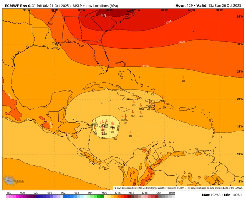
wzrgirl1 wrote:
LarryWx wrote:


Thanks. Yes, the 6Z Euro op is near the most NE 6Z EPS members. The large majority are 300-500 miles WSW to SW of the Euro op!


So in terms of these models, the operational versus the others which is the one we’re supposed to rely on?


At 144 hours out, the ensemble mean is usually though not always a better indicator with this much of a difference.
Regardless, nothing should actually be relied on as models are tools rather than crystal balls.
Last edited by LarryWx on Tue Oct 21, 2025 8:15 am, edited 2 times in total.
1 likes   
Personal Forecast Disclaimer:
The posts in this forum are NOT official forecasts and should not be used as such. They are just the opinion of the poster and may or may not be backed by sound meteorological data. They are NOT endorsed by any professional institution or storm2k.org. For official information, please refer to the NHC and NWS products.

User avatar
SFLcane
S2K Supporter
S2K Supporter
Posts: 10274
Age: 47
Joined: Sat Jun 05, 2010 1:44 pm
Location: Lake Worth Florida

Re: NATL: INVEST 98L - Models

#122 Postby SFLcane » Tue Oct 21, 2025 8:14 am

06z FNV3 also moving away from a quick NE hook.
0 likes   

User avatar
REDHurricane
Category 1
Category 1
Posts: 433
Age: 28
Joined: Sun Jul 03, 2022 2:36 pm
Location: Northeast Pacific Ocean

Re: NATL: INVEST 98L - Models

#123 Postby REDHurricane » Tue Oct 21, 2025 8:15 am

Kazmit wrote:Excited to see an epic fail from either the GFS or the Euro. Remember, the GFS showed Jerry becoming a major hurricane as it was actively dissipating. :lol:


I have a feeling that the GFS is going to take another L here due to its infamous insistence on developing/strengthening systems far too quickly in this part of the Caribbean specifically (something about how it deals with how the nearby mountains affect wind patterns maybe?). Even though I've only been paying close attention to hurricane season for several years now, it seems like storms always struggle to get going down there until they reach ~75ºW and then tend to rapidly intensify given that they survive long enough for the wind shear to abate. I'm guessing that we probably won't see much more development for the next 48-72 hours or so until shear conditions begin to improve a bit, at least according to t h e m o d e l s
0 likes   

TomballEd
Category 5
Category 5
Posts: 1054
Age: 61
Joined: Wed Aug 16, 2023 4:52 pm
Location: Spring/Klein area, not Tomball

Re: NATL: INVEST 98L - Models

#124 Postby TomballEd » Tue Oct 21, 2025 8:46 am

The ensembles all seem to show a split, some weighted more N and NE, some weighted more W or SW. Or minor changes in the initial conditions produce major changes in the output.
0 likes   

User avatar
kevin
Category 5
Category 5
Posts: 2770
Age: 27
Joined: Wed Aug 28, 2019 4:35 am

Re: NATL: INVEST 98L - Models

#125 Postby kevin » Tue Oct 21, 2025 8:51 am

Early 12z guidance trending slightly more west. 06z had TVCN was over western Haiti and then NE. Now it's west of Haiti and on its way to the eastern tip of Cuba at +120hr. Note that due to the enormous solution space and the bifurcation in solutions (AVN is ~750 miles NE of HFAI at +5 days) the exact path of the TVCN consensus is not all that useful to determine the exact path. But of the 4 - 5 models that took this over Haiti/DR just 12 hours ago, now there are only 2 left. Still lots of uncertainty.

Image
2 likes   

LarryWx
S2K Supporter
S2K Supporter
Posts: 6807
Joined: Sun Sep 07, 2003 2:04 pm
Location: GA

Re: NATL: INVEST 98L - Models

#126 Postby LarryWx » Tue Oct 21, 2025 9:03 am

kevin wrote:Early 12z guidance trending slightly more west. 06z had TVCN was over western Haiti and then NE. Now it's west of Haiti and on its way to the eastern tip of Cuba at +120hr. Note that due to the enormous solution space and the bifurcation in solutions (AVN is ~750 miles NE of HFAI at +5 days) the exact path of the TVCN consensus is not all that useful to determine the exact path. But of the 4 - 5 models that took this over Haiti/DR just 12 hours ago, now there are only 2 left. Still lots of uncertainty.

https://i.imgur.com/NHPZOHI.png


A large majority of 6Z Euro ensemble members are hundreds of miles W to WSW of most of these at 144!
0 likes   
Personal Forecast Disclaimer:
The posts in this forum are NOT official forecasts and should not be used as such. They are just the opinion of the poster and may or may not be backed by sound meteorological data. They are NOT endorsed by any professional institution or storm2k.org. For official information, please refer to the NHC and NWS products.

Fancy1002
Category 1
Category 1
Posts: 261
Joined: Sun Dec 25, 2022 3:47 pm

Re: NATL: INVEST 98L - Models

#127 Postby Fancy1002 » Tue Oct 21, 2025 9:21 am

kevin wrote:Early 12z guidance trending slightly more west. 06z had TVCN was over western Haiti and then NE. Now it's west of Haiti and on its way to the eastern tip of Cuba at +120hr. Note that due to the enormous solution space and the bifurcation in solutions (AVN is ~750 miles NE of HFAI at +5 days) the exact path of the TVCN consensus is not all that useful to determine the exact path. But of the 4 - 5 models that took this over Haiti/DR just 12 hours ago, now there are only 2 left. Still lots of uncertainty.

https://i.imgur.com/NHPZOHI.png

I think all you have to do to get someone who doesn’t understand much about hurricanes, to understand why tracking the storm is going to be such a headache, all you have to do is show them that picture
0 likes   

Fancy1002
Category 1
Category 1
Posts: 261
Joined: Sun Dec 25, 2022 3:47 pm

Re: NATL: MELISSA - Models

#128 Postby Fancy1002 » Tue Oct 21, 2025 9:23 am

I can’t remember the last time I’ve seen this much disagreement from the models over a short time period.
1 likes   

User avatar
SFLcane
S2K Supporter
S2K Supporter
Posts: 10274
Age: 47
Joined: Sat Jun 05, 2010 1:44 pm
Location: Lake Worth Florida

Re: NATL: MELISSA - Models

#129 Postby SFLcane » Tue Oct 21, 2025 9:26 am

0 likes   

caneseddy
Category 5
Category 5
Posts: 1192
Joined: Fri Sep 03, 2004 9:31 pm
Location: Plantation, FL

Re: NATL: MELISSA - Models

#130 Postby caneseddy » Tue Oct 21, 2025 9:45 am

FWIW, the Korean model has a hurricane landfalling around the Naples area heading NE on Halloween. It initially landfalls in Honduras/Nicaragua, bounces right back out into water by Belize, reintensifies into a major hurricane while heading towards South Florida....unfortunately don't have the ability to upload right now so..
0 likes   

User avatar
boca
Category 5
Category 5
Posts: 6393
Age: 61
Joined: Mon Dec 15, 2003 8:49 am
Location: Boca Raton,FL

Re: NATL: MELISSA - Models

#131 Postby boca » Tue Oct 21, 2025 9:58 am

caneseddy wrote:FWIW, the Korean model has a hurricane landfalling around the Naples area heading NE on Halloween. It initially landfalls in Honduras/Nicaragua, bounces right back out into water by Belize, reintensifies into a major hurricane while heading towards South Florida....unfortunately don't have the ability to upload right now so..


How is that models track record ?
0 likes   

BobHarlem
Category 5
Category 5
Posts: 2515
Joined: Thu Oct 20, 2005 6:11 pm

Re: NATL: MELISSA - Models

#132 Postby BobHarlem » Tue Oct 21, 2025 10:12 am

boca wrote:
caneseddy wrote:FWIW, the Korean model has a hurricane landfalling around the Naples area heading NE on Halloween. It initially landfalls in Honduras/Nicaragua, bounces right back out into water by Belize, reintensifies into a major hurricane while heading towards South Florida....unfortunately don't have the ability to upload right now so..


How is that models track record ?


Abysmal outside the Philippine Sea.
2 likes   

Pelicane
Tropical Storm
Tropical Storm
Posts: 179
Joined: Tue Sep 13, 2022 1:52 pm
Location: Lafayette, Louisiana

Re: NATL: MELISSA - Models

#133 Postby Pelicane » Tue Oct 21, 2025 10:45 am

ICON trended much weaker.
0 likes   

caneseddy
Category 5
Category 5
Posts: 1192
Joined: Fri Sep 03, 2004 9:31 pm
Location: Plantation, FL

Re: NATL: MELISSA - Models

#134 Postby caneseddy » Tue Oct 21, 2025 10:56 am

12z GFS still sticking to its guns of a hurricane landfall on Hispaniola moving NE on Friday
Last edited by caneseddy on Tue Oct 21, 2025 10:56 am, edited 1 time in total.
0 likes   

Keldeo1997
Category 2
Category 2
Posts: 658
Joined: Fri Oct 11, 2019 11:35 pm

Re: NATL: MELISSA - Models

#135 Postby Keldeo1997 » Tue Oct 21, 2025 10:56 am

 https://x.com/NDGMETCHEF/status/1980644955749073379


We have a long way to go. Everyone including gulf is still in play
0 likes   

AutoPenalti
Category 5
Category 5
Posts: 4088
Age: 29
Joined: Mon Aug 17, 2015 4:16 pm
Location: Ft. Lauderdale, Florida

Re: NATL: MELISSA - Models

#136 Postby AutoPenalti » Tue Oct 21, 2025 11:05 am

12z ensembles will be interesting.
1 likes   
The posts in this forum are NOT official forecasts and should not be used as such. They are just the opinion of the poster and may or may not be backed by sound meteorological data. They are NOT endorsed by any professional institution or STORM2K. For official information, please refer to products from the NHC and NWS.


Model Runs Cheat Sheet:
GFS (5:30 AM/PM, 11:30 AM/PM)
HWRF, GFDL, UKMET, NAVGEM (6:30-8:00 AM/PM, 12:30-2:00 AM/PM)
ECMWF (1:45 AM/PM)

TCVN
is a weighted averaged

User avatar
ScottNAtlanta
Category 5
Category 5
Posts: 2475
Joined: Sat May 25, 2013 3:11 pm
Location: Atlanta, GA

Re: NATL: MELISSA - Models

#137 Postby ScottNAtlanta » Tue Oct 21, 2025 11:06 am

Seeing how this meets the forecast points will be important with this one. If it starts missing to the west, that has implications going forward.
2 likes   
The posts in this forum are NOT official forecast and should not be used as such. They are just the opinion of the poster and may or may not be backed by sound meteorological data. They are NOT endorsed by any professional institution or storm2k.org. For official information, please refer to the NHC and NWS products.

Weathertracker96
Tropical Storm
Tropical Storm
Posts: 148
Joined: Mon Oct 16, 2023 3:41 pm

Re: NATL: MELISSA - Models

#138 Postby Weathertracker96 » Tue Oct 21, 2025 11:33 am

The 12z CMC is surely interesting.
0 likes   

User avatar
wzrgirl1
S2K Supporter
S2K Supporter
Posts: 1359
Joined: Sat Sep 04, 2004 6:44 am
Location: Pembroke Pines, Florida

Re: NATL: MELISSA - Models

#139 Postby wzrgirl1 » Tue Oct 21, 2025 11:46 am

Weathertracker96 wrote:The 12z CMC is surely interesting.


Hi, you can’t make a statement like that and not post the graphic lol
2 likes   

Weathertracker96
Tropical Storm
Tropical Storm
Posts: 148
Joined: Mon Oct 16, 2023 3:41 pm

Re: NATL: MELISSA - Models

#140 Postby Weathertracker96 » Tue Oct 21, 2025 11:51 am

wzrgirl1 wrote:
Weathertracker96 wrote:The 12z CMC is surely interesting.


Hi, you can’t make a statement like that and not post the graphic lol


My apologizes lol. I still get stuck on how to post pictures on here. But the CMC has the system going more west and NE through central Cuba. But looking at the 12z GEFS, the ensembles seem more spread out than before. Hopefully recon will clear all this up.
1 likes   


Return to “Active Storms/Invests - Atlantic/EastPAC/CentralPAC/MED”

Who is online

Users browsing this forum: cycloneye, pepecool20 and 77 guests