NATL: MELISSA - Models

Moderator: S2k Moderators

Message
Author
Cachondo23
Tropical Storm
Tropical Storm
Posts: 131
Joined: Wed May 25, 2022 5:56 am

Re: NATL: MELISSA - Tropical Storm - Discussion

#161 Postby Cachondo23 » Tue Oct 21, 2025 5:51 pm

Kazmit wrote:
GCANE wrote:Chances going down quickly for a hit on Haiti.
Majority has a path to the West Carib

https://rammb-data.cira.colostate.edu/t ... 211800.png

https://rammb-data.cira.colostate.edu/t ... 210600.png

And yet, the 18z GFS has a DR landfall. :lol:

At the beginning of the models, it was a love/hate situation with PR now is DR!
0 likes   

zzzh
Category 5
Category 5
Posts: 1026
Joined: Thu Sep 02, 2021 1:13 pm

Re: NATL: MELISSA - Models

#162 Postby zzzh » Tue Oct 21, 2025 6:31 pm

18z ECAI trended way stronger. It's been the worst model for this system along with GFS.
0 likes   

User avatar
aspen
Category 5
Category 5
Posts: 9041
Joined: Sat Oct 12, 2019 7:10 pm
Location: Connecticut, USA

Re: NATL: MELISSA - Models

#163 Postby aspen » Tue Oct 21, 2025 7:00 pm

All four hurricane models have trended weaker and more SW in the short-term. The HWRF has trended less so and is still comparable to the GFS, but it’s still noticeable.

HMON stalls and RIs just south of Jamaica. Very scary if that pans out.

HAFS-A/B start intensifying a little further away from Jamaica than the HMON.
3 likes   
Irene '11 Sandy '12 Hermine '16 5/15/2018 Derecho Fay '20 Isaias '20 Elsa '21 Henri '21 Ida '21

I am only a meteorology enthusiast who knows a decent amount about tropical cyclones. Look to the professional mets, the NHC, or your local weather office for the best information.

User avatar
SFLcane
S2K Supporter
S2K Supporter
Posts: 10281
Age: 48
Joined: Sat Jun 05, 2010 1:44 pm
Location: Lake Worth Florida

Re: NATL: MELISSA - Models

#164 Postby SFLcane » Tue Oct 21, 2025 7:12 pm

aspen wrote:All four hurricane models have trended weaker and more SW in the short-term. The HWRF has trended less so and is still comparable to the GFS, but it’s still noticeable.

HMON stalls and RIs just south of Jamaica. Very scary if that pans out.

HAFS-A/B start intensifying a little further away from Jamaica than the HMON.


No stall on the HMON it continues on a W/WSW course south of Jamaica.

Image
4 likes   

User avatar
SFLcane
S2K Supporter
S2K Supporter
Posts: 10281
Age: 48
Joined: Sat Jun 05, 2010 1:44 pm
Location: Lake Worth Florida

Re: NATL: MELISSA - Models

#165 Postby SFLcane » Tue Oct 21, 2025 7:20 pm

18z Hafs-b.. see ya Jamaica.

Image
2 likes   

User avatar
SFLcane
S2K Supporter
S2K Supporter
Posts: 10281
Age: 48
Joined: Sat Jun 05, 2010 1:44 pm
Location: Lake Worth Florida

Re: NATL: MELISSA - Models

#166 Postby SFLcane » Tue Oct 21, 2025 7:23 pm

1 likes   

User avatar
WaveBreaking
Category 2
Category 2
Posts: 708
Joined: Sun Jun 30, 2024 11:33 am
Location: US

Re: NATL: MELISSA - Models

#167 Postby WaveBreaking » Tue Oct 21, 2025 7:25 pm

Nothing is obviously set in stone rn but I can’t see a possibility where Melissa doesn’t bomb out in the environment the HAFS models are showing unless convection never fires over the LLC again for some reason.

Image
Image
Image
Image

The posts in this forum are NOT official forecasts and should not be used as such. They are just the opinion of the poster and may or may not be backed by sound meteorological data. They are NOT endorsed by any professional institution or STORM2K. For official information, please refer to products from the NHC and NWS.
5 likes   
I am NOT a professional meteorologist, so take all of my posts with a grain of salt. My opinions are mine and mine alone.

User avatar
Hurricane2022
Category 5
Category 5
Posts: 1949
Joined: Tue Aug 23, 2022 11:38 pm
Location: Araçatuba, Brazil

Re: NATL: MELISSA - Models

#168 Postby Hurricane2022 » Tue Oct 21, 2025 7:55 pm

WaveBreaking wrote:Nothing is obviously set in stone rn but I can’t see a possibility where Melissa doesn’t bomb out in the environment the HAFS models are showing unless convection never fires over the LLC again for some reason.

https://i.imgur.com/yHLF3Kt.png
https://i.imgur.com/18DFG6J.png
https://i.imgur.com/137i1jc.png
https://i.imgur.com/mRztpEs.png

The posts in this forum are NOT official forecasts and should not be used as such. They are just the opinion of the poster and may or may not be backed by sound meteorological data. They are NOT endorsed by any professional institution or STORM2K. For official information, please refer to products from the NHC and NWS.

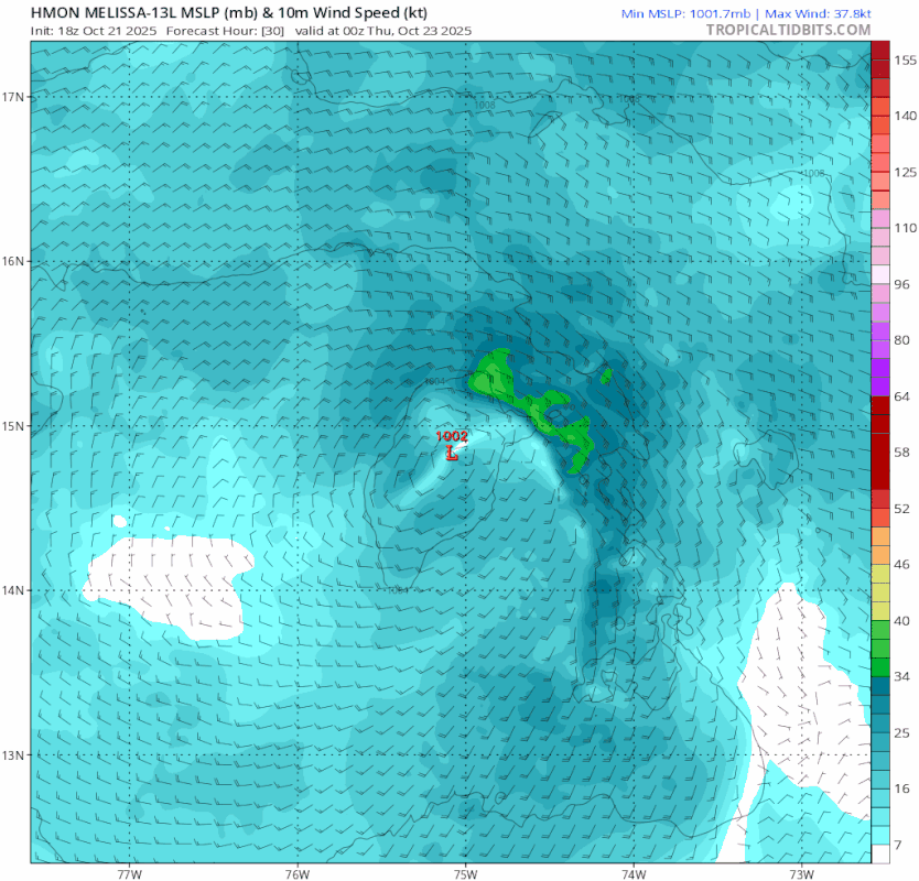
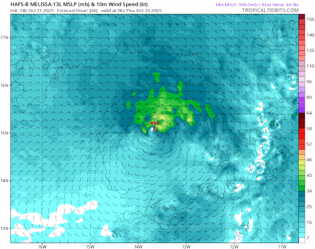
This environment would very easily take Melissa to the highest level of Atlantic hurricanes. There we have more than enough time for the system to rival historic hurricanes like Three '33, Gilbert '88, and Wilma '05, as well as cyclones from other basins, such as Hagibis '19, Jova '23, Olaf '05, and so on.

If it weren’t for the immense uncertainty about its future path, I would have no problem saying that I would expect Melissa to become a record-breaking hurricane.
The posts in this forum are NOT official forecasts and should not be used as such. They are just the opinion of the poster and may or may not be backed by sound meteorological data. They are NOT endorsed by any professional institution or STORM2K. For official information, please refer to products from the NHC and NWS.
4 likes   
Sorry for the bad English sometimes...!
For reliable and detailed information for any meteorological phenomenon, please consult the National Hurricane Center, Joint Typhoon Warning Center , or your local Meteo Center.

--------

ECCE OMNIA NOVA FACIAM (Ap 21,5).

User avatar
Iceresistance
Category 5
Category 5
Posts: 9413
Age: 22
Joined: Sat Oct 10, 2020 9:45 am
Location: Tecumseh, OK/Norman, OK

Re: NATL: MELISSA - Models

#169 Postby Iceresistance » Tue Oct 21, 2025 8:03 pm

Well, the FNV3 is back at it again with insane runs, like this 887 mb member on this 18z
Image
https://s12.gifyu.com/images/b397b.png
5 likes   
Bill 2015 & Beta 2020

Winter 2020-2021 :cold:

All observations are in Tecumseh, OK unless otherwise noted.

Winter posts are focused mainly for Oklahoma & Texas.

Take any of my forecasts with a grain of salt, refer to the NWS, SPC, and NHC for official information

Never say Never with weather! Because ANYTHING is possible!

User avatar
Hurricane2022
Category 5
Category 5
Posts: 1949
Joined: Tue Aug 23, 2022 11:38 pm
Location: Araçatuba, Brazil

Re: NATL: MELISSA - Models

#170 Postby Hurricane2022 » Tue Oct 21, 2025 8:04 pm

One of the things I enjoy most about hurricane forecasting is looking at the IR simulation from the HAFS-A and B models.
It's always wonderful to see how the tropical cyclones are almost perfectly drawn on these maps
ImageImage
8 likes   
Sorry for the bad English sometimes...!
For reliable and detailed information for any meteorological phenomenon, please consult the National Hurricane Center, Joint Typhoon Warning Center , or your local Meteo Center.

--------

ECCE OMNIA NOVA FACIAM (Ap 21,5).

User avatar
ronjon
Category 5
Category 5
Posts: 4890
Joined: Fri Aug 19, 2005 5:17 pm
Location: Hernando Beach, FL

Re: NATL: MELISSA - Models

#171 Postby ronjon » Tue Oct 21, 2025 8:08 pm

The HAFS models show a signicant hurricane on a W-SW course approaching 80W longitude near 14N in 5 days. I don't have tell anyone what longitude Miami sits at. Now future troughs will likely steer it NE but the further west it gets will determine how close it gets to the keys and S FL.
4 likes   

User avatar
Hurricane2022
Category 5
Category 5
Posts: 1949
Joined: Tue Aug 23, 2022 11:38 pm
Location: Araçatuba, Brazil

Re: NATL: MELISSA - Models

#172 Postby Hurricane2022 » Tue Oct 21, 2025 8:21 pm

3 likes   
Sorry for the bad English sometimes...!
For reliable and detailed information for any meteorological phenomenon, please consult the National Hurricane Center, Joint Typhoon Warning Center , or your local Meteo Center.

--------

ECCE OMNIA NOVA FACIAM (Ap 21,5).

Keldeo1997
Category 2
Category 2
Posts: 688
Joined: Fri Oct 11, 2019 11:35 pm

Re: NATL: MELISSA - Models

#173 Postby Keldeo1997 » Tue Oct 21, 2025 8:46 pm

0 likes   

User avatar
SFLcane
S2K Supporter
S2K Supporter
Posts: 10281
Age: 48
Joined: Sat Jun 05, 2010 1:44 pm
Location: Lake Worth Florida

Re: NATL: MELISSA - Models

#174 Postby SFLcane » Tue Oct 21, 2025 9:00 pm

Its think its pretty safe to say at this point the gfs is WRONG !

Image
6 likes   

User avatar
SFLcane
S2K Supporter
S2K Supporter
Posts: 10281
Age: 48
Joined: Sat Jun 05, 2010 1:44 pm
Location: Lake Worth Florida

Re: NATL: MELISSA - Models

#175 Postby SFLcane » Tue Oct 21, 2025 9:07 pm

ronjon wrote:The HAFS models show a signicant hurricane on a W-SW course approaching 80W longitude near 14N in 5 days. I don't have tell anyone what longitude Miami sits at. Now future troughs will likely steer it NE but the further west it gets will determine how close it gets to the keys and S FL.


Image

Image
0 likes   

User avatar
blp
Category 5
Category 5
Posts: 2880
Age: 47
Joined: Thu Sep 09, 2004 7:51 pm
Location: Miami, FL
Contact:

Re: NATL: MELISSA - Models

#176 Postby blp » Tue Oct 21, 2025 9:25 pm

SFLcane wrote:
ronjon wrote:The HAFS models show a signicant hurricane on a W-SW course approaching 80W longitude near 14N in 5 days. I don't have tell anyone what longitude Miami sits at. Now future troughs will likely steer it NE but the further west it gets will determine how close it gets to the keys and S FL.


https://i.imgur.com/HIon03t.png

https://i.imgur.com/BOczOQd.jpeg


Trend on HCCA. :eek:

Image
5 likes   
The following post is NOT an official forecast and should not be used as such. It is just the opinion of the poster and may or may not be backed by sound meteorological data. It is NOT endorsed by any professional institution including storm2k.org For Official Information please refer to the NHC and NWS products.

USTropics
Professional-Met
Professional-Met
Posts: 2731
Joined: Sun Aug 12, 2007 3:45 am
Location: Florida State University

Re: NATL: MELISSA - Models

#177 Postby USTropics » Tue Oct 21, 2025 9:30 pm

SFLcane wrote:Its think its pretty safe to say at this point the gfs is WRONG !

https://i.imgur.com/1xEgE2L.jpeg


Name a more iconic duo than the GFS model and missing Caribbean tropical cyclone forecasts — I’ll wait. :spam:

The ECMWF has had a decent handle on this in conjunction with Google DeepMind ensembles. I would hedge there (they are closely aligned with the HCCA consensus model as well).
4 likes   

User avatar
Teban54
Category 5
Category 5
Posts: 3785
Joined: Sat May 19, 2018 1:19 pm

Re: NATL: MELISSA - Models

#178 Postby Teban54 » Tue Oct 21, 2025 9:33 pm

USTropics wrote:
SFLcane wrote:Its think its pretty safe to say at this point the gfs is WRONG !

https://i.imgur.com/1xEgE2L.jpeg


Name a more iconic duo than the GFS model and missing Caribbean tropical cyclone forecasts — I’ll wait. :spam:

The ECMWF has had a decent handle on this in conjunction with Google DeepMind ensembles. I would hedge there (they are closely aligned with the HCCA consensus model as well).

A possible explanation:
 https://x.com/webberweather/status/1980810036294426797

0 likes   

BobHarlem
Category 5
Category 5
Posts: 2566
Joined: Thu Oct 20, 2005 6:11 pm

Re: NATL: MELISSA - Models

#179 Postby BobHarlem » Tue Oct 21, 2025 10:24 pm

0z Icon is devastating for Jamaica (both long duration impacts and rain) Rain especially bad on the eastern half of the island.
Image
1 likes   

Fancy1002
Category 1
Category 1
Posts: 322
Joined: Sun Dec 25, 2022 3:47 pm

Re: NATL: MELISSA - Models

#180 Postby Fancy1002 » Tue Oct 21, 2025 11:24 pm

It’s stuff like what the CMC is doing. That makes me think south Florida isn’t out of the woodwork.
0 likes   


Return to “2025”

Who is online

Users browsing this forum: No registered users and 21 guests