NATL: MELISSA - Tropical Storm - Discussion
Moderators: hurricanetrack, S2k Moderators

The posts in this forum are NOT official forecasts and should not be used as such. They are just the opinion of the poster and may or may not be backed by sound meteorological data. They are NOT endorsed by any professional institution or STORM2K. For official information, please refer to products from the National Hurricane Center and National Weather Service.

Re: NATL: MELISSA - Tropical Storm - Discussion
She isn’t looking so good at the moment with the shear, but as far west she may get, quite uncertain. Smart money says she will head north east, then east without much ado. But this season has been odd.
0 likes


Re: NATL: MELISSA - Tropical Storm - Discussion
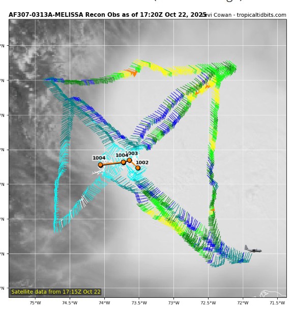
Latest recon fix, less than 10 minutes ago, has center about 35 miles west of forecasted position.
1 likes

Re: NATL: MELISSA - Tropical Storm - Discussion
LarryWx wrote:kevin wrote:I guess this one's for everyone who called the 2025 season boring. This is one of the most difficult (and potentially high-impact) hurricane forecasts in a long time and I say that knowing we also had Humberto/Imelda last month..
Some people who crave destruction consider it “boring” if there are no Conus H landfalls, which looks to continue if Melissa also doesn’t hit there (likely as of now) regardless of how strong it gets. Every storm could get to cat 5 and those folks would still be bored. It’s ingrained in them and it’s hard for that to change. I’ve seen it on other wx boards, too.
To be fair though, there is a major distinction between those with a primarily analytical yet sterile appreciation of meteorological data, graphics, records, and numbers.... and those who quite honestly were turned-on to "severe weather" as a result of seeing or experiencing the ferocious awe of Mother Nature. One cannot be awed by the extreme impact of a hurricane unless one has a frame of reference depicting storm surge and it's effects or the manner in which a major hurricane winds humble ourselves and mankind's mighty construction or technology. Tornado's are potentially a bit different in that one can appreciate a wide angle view of the sky along with the menacing vortex dropping from the sky, potentially over open space with no construction or people around.
Let's be fair though. Most people (myself included) ARE mesmerized when incredible chaser or witness video depicting the manner in which severe weather impacts our world comes forward. I also think that most if not all of us equally cringe at the same time, when witnessing the horribly sad and depressing impact to others where visible. I have zero interest in witnessing a drowning, severe injury occur, or a person whisked away by severe wind.
In the end, it is largely our viewing the world around us which shapes our understanding, appreciation, interest, AND risk mitigation as we move forward.
1 likes
Andy D
(For official information, please refer to the NHC and NWS products.)
(For official information, please refer to the NHC and NWS products.)

Re: NATL: MELISSA - Tropical Storm - Discussion
Latest fix confirms this about to pop out of convection.
0 likes
The following post is NOT an official forecast and should not be used as such. It is just the opinion of the poster and may or may not be backed by sound meteorological data. It is NOT endorsed by any professional institution including storm2k.org For Official Information please refer to the NHC and NWS products.
-
WaveBreaking

- Category 2

- Posts: 640
- Joined: Sun Jun 30, 2024 11:33 am
- Location: US
Re: NATL: MELISSA - Tropical Storm - Discussion
kevin wrote:The stars are aligning for a monster hurricane. But remember that this also was the case with Delta in 2020. Everyone was already calling it a future cat 5 when it was a cat 1. And then last minute unexpected shear caused the pinhole to collapse. Nothing is set in stone yet. Let's at least hope this misses Jamaica and other populated areas during its lifetime, even though that is difficult to achieve in the WCar.
I feel like what sets Delta apart from Melissa is that TS Gamma was in the vicinity of Delta, which probably contributed to dry air getting into Delta’s core due to it shoveling in continental air from the Yucatan. Not trying to say you’re wrong or anything since you’re right in how literally anything could happen to stop Melissa from being record-breaking.
4 likes
I am NOT a professional meteorologist, so take all of my posts with a grain of salt. My opinions are mine and mine alone.
Re: NATL: MELISSA - Tropical Storm - Discussion
chaser1 wrote:LarryWx wrote:kevin wrote:I guess this one's for everyone who called the 2025 season boring. This is one of the most difficult (and potentially high-impact) hurricane forecasts in a long time and I say that knowing we also had Humberto/Imelda last month..
Some people who crave destruction consider it “boring” if there are no Conus H landfalls, which looks to continue if Melissa also doesn’t hit there (likely as of now) regardless of how strong it gets. Every storm could get to cat 5 and those folks would still be bored. It’s ingrained in them and it’s hard for that to change. I’ve seen it on other wx boards, too.
To be fair though, there is a major distinction between those with a primarily analytical yet sterile appreciation of meteorological data, graphics, records, and numbers.... and those who quite honestly were turned-on to "severe weather" as a result of seeing or experiencing the ferocious awe of Mother Nature. One cannot be awed by the extreme impact of a hurricane unless one has a frame of reference depicting storm surge and it's effects or the manner in which a major hurricane winds humble ourselves and mankind's mighty construction or technology. Tornado's are potentially a bit different in that one can appreciate a wide angle view of the sky along with the menacing vortex dropping from the sky, potentially over open space with no construction or people around.
Let's be fair though. Most people (myself included) ARE mesmerized when incredible chaser or witness video depicting the manner in which severe weather impacts our world comes forward. I also think that most if not all of us equally cringe at the same time, when witnessing the horribly sad and depressing impact to others where visible. I have zero interest in witnessing a drowning, severe injury occur, or a person whisked away by severe wind.
In the end, it is largely our viewing the world around us which shapes our understanding, appreciation, interest, AND risk mitigation as we move forward.
Hey Chaser,
For specific examples of what I’m referring to, please go to the link below, if interested, and reply to that there if you’d like to (if you don’t mind). Keep in mind that I’ve followed these 5 folks’ posts for awhile in addition to other posters with similar desires. So, I’m quite familiar with their repeatedly honestly stated desires regarding hurricanes:
https://www.storm2k.org/phpbb2/viewtopi ... 0#p3142975
0 likes
Personal Forecast Disclaimer:
The posts in this forum are NOT official forecasts and should not be used as such. They are just the opinion of the poster and may or may not be backed by sound meteorological data. They are NOT endorsed by any professional institution or storm2k.org. For official information, please refer to the NHC and NWS products.
The posts in this forum are NOT official forecasts and should not be used as such. They are just the opinion of the poster and may or may not be backed by sound meteorological data. They are NOT endorsed by any professional institution or storm2k.org. For official information, please refer to the NHC and NWS products.
-
ElectricStorm

- Category 5

- Posts: 5105
- Age: 24
- Joined: Tue Aug 13, 2019 11:23 pm
- Location: Skiatook, OK / Norman, OK
Re: NATL: MELISSA - Tropical Storm - Discussion
Everyone talks about the I curse and rightfully so, but the M curse is alive and well the last decade or so. Hopefully this one can somehow avoid major impacts, as I don't really see anything stopping this from hitting Cat 4+ in a few days.
5 likes
B.S Meteorology, University of Oklahoma '25
Please refer to the NHC, NWS, or SPC for official information.
Please refer to the NHC, NWS, or SPC for official information.
-
TomballEd
- Category 5
- Posts: 1057
- Age: 61
- Joined: Wed Aug 16, 2023 4:52 pm
- Location: Spring/Klein area, not Tomball
Re: NATL: MELISSA - Tropical Storm - Discussion
The MLC is visible in IR satellite. It is well E of the LLC. Melissa still has time to spin down harmlessly.
0 likes
Re: NATL: MELISSA - Tropical Storm - Discussion
ElectricStorm wrote:Everyone talks about the I curse and rightfully so, but the M curse is alive and well the last decade or so. Hopefully this one can somehow avoid major impacts, as I don't really see anything stopping this from hitting Cat 4+ in a few days.
It’s unsurprising that I and M have some infamous names. I tends to show up around the season peak, while M tends to show up in the late season peak.
2 likes
-
storm_in_a_teacup

- Category 1

- Posts: 474
- Age: 33
- Joined: Wed Aug 16, 2017 5:01 pm
- Location: Huntsville, Alabama (originally from Houston)
- Contact:
Re: NATL: MELISSA - Tropical Storm - Discussion
LarryWx wrote:chaser1 wrote:LarryWx wrote:
Some people who crave destruction consider it “boring” if there are no Conus H landfalls, which looks to continue if Melissa also doesn’t hit there (likely as of now) regardless of how strong it gets. Every storm could get to cat 5 and those folks would still be bored. It’s ingrained in them and it’s hard for that to change. I’ve seen it on other wx boards, too.
To be fair though, there is a major distinction between those with a primarily analytical yet sterile appreciation of meteorological data, graphics, records, and numbers.... and those who quite honestly were turned-on to "severe weather" as a result of seeing or experiencing the ferocious awe of Mother Nature. One cannot be awed by the extreme impact of a hurricane unless one has a frame of reference depicting storm surge and it's effects or the manner in which a major hurricane winds humble ourselves and mankind's mighty construction or technology. Tornado's are potentially a bit different in that one can appreciate a wide angle view of the sky along with the menacing vortex dropping from the sky, potentially over open space with no construction or people around.
Let's be fair though. Most people (myself included) ARE mesmerized when incredible chaser or witness video depicting the manner in which severe weather impacts our world comes forward. I also think that most if not all of us equally cringe at the same time, when witnessing the horribly sad and depressing impact to others where visible. I have zero interest in witnessing a drowning, severe injury occur, or a person whisked away by severe wind.
In the end, it is largely our viewing the world around us which shapes our understanding, appreciation, interest, AND risk mitigation as we move forward.
Hey Chaser,
For specific examples of what I’m referring to, please go to the link below, if interested, and reply to that there if you’d like to (if you don’t mind). Keep in mind that I’ve followed these 5 folks’ posts for awhile in addition to other posters with similar desires. So, I’m quite familiar with their repeatedly honestly stated desires regarding hurricanes:
https://www.storm2k.org/phpbb2/viewtopi ... 0#p3142975
Oh no please don’t start the dreaded r/tropicalweather “how much hurricane enthusiasm is too much???” fight again.
(Also, never post storm personifications on Reddit)
3 likes
I know I can't straddle the atmosphere...just a tiny storm in your teacup, girl.
Re: NATL: MELISSA - Tropical Storm - Discussion
storm_in_a_teacup wrote:LarryWx wrote:chaser1 wrote:
To be fair though, there is a major distinction between those with a primarily analytical yet sterile appreciation of meteorological data, graphics, records, and numbers.... and those who quite honestly were turned-on to "severe weather" as a result of seeing or experiencing the ferocious awe of Mother Nature. One cannot be awed by the extreme impact of a hurricane unless one has a frame of reference depicting storm surge and it's effects or the manner in which a major hurricane winds humble ourselves and mankind's mighty construction or technology. Tornado's are potentially a bit different in that one can appreciate a wide angle view of the sky along with the menacing vortex dropping from the sky, potentially over open space with no construction or people around.
Let's be fair though. Most people (myself included) ARE mesmerized when incredible chaser or witness video depicting the manner in which severe weather impacts our world comes forward. I also think that most if not all of us equally cringe at the same time, when witnessing the horribly sad and depressing impact to others where visible. I have zero interest in witnessing a drowning, severe injury occur, or a person whisked away by severe wind.
In the end, it is largely our viewing the world around us which shapes our understanding, appreciation, interest, AND risk mitigation as we move forward.
Hey Chaser,
For specific examples of what I’m referring to, please go to the link below, if interested, and reply to that there if you’d like to (if you don’t mind). Keep in mind that I’ve followed these 5 folks’ posts for awhile in addition to other posters with similar desires. So, I’m quite familiar with their repeatedly honestly stated desires regarding hurricanes:
https://www.storm2k.org/phpbb2/viewtopi ... 0#p3142975
Oh no please don’t start the dreaded r/tropicalweather “how much hurricane enthusiasm is too much???” fight again.
(Also, never post storm personifications on Reddit)
I didn’t start anything. I was originally responding to the following post that brought up the boredom of some to explain why certain people will continue to be bored thus implying that the intriguingly hard Melissa forecast won’t change a thing for them. I didn’t say anything about “how much enthusiasm is too much” and am not fighting:
I guess this one's for everyone who called the 2025 season boring. This is one of the most difficult (and potentially high-impact) hurricane forecasts in a long time and I say that knowing we also had Humberto/Imelda last month.
0 likes
Personal Forecast Disclaimer:
The posts in this forum are NOT official forecasts and should not be used as such. They are just the opinion of the poster and may or may not be backed by sound meteorological data. They are NOT endorsed by any professional institution or storm2k.org. For official information, please refer to the NHC and NWS products.
The posts in this forum are NOT official forecasts and should not be used as such. They are just the opinion of the poster and may or may not be backed by sound meteorological data. They are NOT endorsed by any professional institution or storm2k.org. For official information, please refer to the NHC and NWS products.

-
KirbyDude25

- Tropical Storm

- Posts: 155
- Age: 20
- Joined: Mon Sep 20, 2021 8:03 am
- Location: Westfield, New Jersey
Re: NATL: MELISSA - Tropical Storm - Discussion
It's fine, I think we all know what you're referring to (either this intensity guidance summary on TT or the last frame of the model run)
0 likes
New Jersey, Rutgers '27
Irene 2011 | Sandy 2012 | Fay 2020 | Isaias 2020 | Ida 2021
Irene 2011 | Sandy 2012 | Fay 2020 | Isaias 2020 | Ida 2021
-
WaveBreaking
- Category 2
- Posts: 640
- Joined: Sun Jun 30, 2024 11:33 am
- Location: US
Re: NATL: MELISSA - Tropical Storm - Discussion
Tried my best at recreating the GeoColor product with the Red, Blue, and Veggie Bands and ended up with this.

3 likes
I am NOT a professional meteorologist, so take all of my posts with a grain of salt. My opinions are mine and mine alone.
-
AJC3

- Admin

- Posts: 4125
- Age: 61
- Joined: Tue Aug 31, 2004 7:04 pm
- Location: Ballston Spa, New York
- Contact:
Re: NATL: MELISSA - Tropical Storm - Discussion
Nuno wrote:AJC3 wrote:al78 wrote:Looking at the latest discussion/advisories from NHC, can someone explain why Haiti is under a hurricane watch whilst Jamaica is only under a tropical storm watch, even though the forecast track has the storm almost landfalling on the eastern tip of Jamaica as a hurricane and is some distance from Haiti through the next five days? I'd have thought the watches would have been the other way around with that forecast track.
That's entirely up to the government of the impacted country. If I had to make an educated guess, Haiti is erring on the side of extreme caution. The forecast track (extreme slowdown in forward speed), intensity and "right sided" wind radii, altogether really only justified a TS watch for them (for now) at the time it was issued . It's hard to see any land (or even marine) area getting Hurricane force winds at T+48 hours from 03Z.
I always thought the NHC made recommendations that countries implemented based on their advice. Formally it is up to the country but do they implement such warnings or watches without the NHC filling them in on it?
You are exactly right. NHC will propose watches/warnings to the met agencies of foreign counties (or, for those without met agencies, other government entities which make those decisions) and it is then entirely their decision on what to do. There have been a few cases in the past where and NHC advisory had verbiage such as "NHC recommends a XXX Watch/Warning for ...." but that hasn't occurred in a very long time, probably ~2 decades, if my memory serves me correctly. I know at least one of those was because they couldn't actually get a hold of a POC there (which can happen , especially for the 09Z package).
Similarly, NHC does not unilaterally issue watches/warnings for the U.S. coastline either. They propose the same watches/warnings to local NWS offices, which are almost always agreed upon. The big difference in this case is that when there is disagreement, NHC has a lot more influence on the final decision, and local WFOs will invariably acquiesce to them. But those cases are very rare. CONUS watches/warnings are hammered out starting in the hour preceding the agency confrence call which, in turn, takes place an hour before the 03Z/09Z/15Z/21Z packages are issued.
5 likes
Re: NATL: MELISSA - Tropical Storm - Discussion
LarryWx wrote:storm_in_a_teacup wrote:LarryWx wrote:
Hey Chaser,
For specific examples of what I’m referring to, please go to the link below, if interested, and reply to that there if you’d like to (if you don’t mind). Keep in mind that I’ve followed these 5 folks’ posts for awhile in addition to other posters with similar desires. So, I’m quite familiar with their repeatedly honestly stated desires regarding hurricanes:
https://www.storm2k.org/phpbb2/viewtopi ... 0#p3142975
Oh no please don’t start the dreaded r/tropicalweather “how much hurricane enthusiasm is too much???” fight again.
(Also, never post storm personifications on Reddit)
I didn’t start anything. I was originally responding to the following post that brought up the boredom of some to explain why certain people will continue to be bored thus implying that the intriguingly hard Melissa forecast won’t change a thing for them. I didn’t say anything about “how much enthusiasm is too much” and am not fighting:
I guess this one's for everyone who called the 2025 season boring. This is one of the most difficult (and potentially high-impact) hurricane forecasts in a long time and I say that knowing we also had Humberto/Imelda last month.
There's no controversy here and I appreciate the point Larry is making. The discussion is not about "enthusiasm", it's primarily about the manner how some people communicate & being socially aware.
Anyway............. back to our regularly scheduled tropical storm
2 likes
Andy D
(For official information, please refer to the NHC and NWS products.)
(For official information, please refer to the NHC and NWS products.)
-
CrazyC83
- Professional-Met

- Posts: 34141
- Joined: Tue Mar 07, 2006 11:57 pm
- Location: Deep South, for the first time!
Re: NATL: MELISSA - Tropical Storm - Discussion
Zonacane wrote:Melissa is going to be weak and disorganized for a couple days, Melissa is still going to be a record breaking storm.
And that is why the models go nuts. If Melissa strengthened to, say category 1 or 2, now in spite of the shear, it would be Hispaniola bound. But instead it's so weak that the first front isn't a factor at all. Hence the current westward movement.
There's little to suggest strengthening in the short term. It's the middle and long term where the questions lie...
4 likes

Re: NATL: MELISSA - Tropical Storm - Discussion
I really want to see what pressure that yielded at the very end. It’s got to be in the 870s, maybe even 860s.
0 likes
Irene '11 Sandy '12 Hermine '16 5/15/2018 Derecho Fay '20 Isaias '20 Elsa '21 Henri '21 Ida '21
I am only a meteorology enthusiast who knows a decent amount about tropical cyclones. Look to the professional mets, the NHC, or your local weather office for the best information.
I am only a meteorology enthusiast who knows a decent amount about tropical cyclones. Look to the professional mets, the NHC, or your local weather office for the best information.
Re: NATL: MELISSA - Tropical Storm - Discussion
CrazyC83 wrote:Zonacane wrote:Melissa is going to be weak and disorganized for a couple days, Melissa is still going to be a record breaking storm.
And that is why the models go nuts. If Melissa strengthened to, say category 1 or 2, now in spite of the shear, it would be Hispaniola bound. But instead it's so weak that the first front isn't a factor at all. Hence the current westward movement.
There's little to suggest strengthening in the short term. It's the middle and long term where the questions lie...
Speaking of weak, that LLC is looking REAL shallow. I'm frankly surprised that there's been any fall in pressure during the day. I would have expected a 2-4 mb rise. Another note, Melissa's current state lends a bit more light on whichever model a few days ago also developing a second further west Caribbean disturbance while Melissa stalled and struggled further east. That particular model representation like illustrated the full LLC detachment from the storm and that LLC continuing westward until itself re-establishing convection and altogether new core.
0 likes
Andy D
(For official information, please refer to the NHC and NWS products.)
(For official information, please refer to the NHC and NWS products.)
-
WaveBreaking
- Category 2
- Posts: 640
- Joined: Sun Jun 30, 2024 11:33 am
- Location: US
Re: NATL: MELISSA - Tropical Storm - Discussion
aspen wrote:
I really want to see what pressure that yielded at the very end. It’s got to be in the 870s, maybe even 860s.
All we gotta do is wait for the 18z run to load. I’m guessing 871 mbar.
2 likes
I am NOT a professional meteorologist, so take all of my posts with a grain of salt. My opinions are mine and mine alone.
Return to “Active Storms/Invests - Atlantic/EastPAC/CentralPAC/MED”
Who is online
Users browsing this forum: islandgirl45, stormchazer and 72 guests