NATL: MELISSA - Aftermath - Discussion
Moderator: S2k Moderators
-
TomballEd
- Category 5

- Posts: 1322
- Age: 62
- Joined: Wed Aug 16, 2023 4:52 pm
- Location: Spring/Klein area, not Tomball
Re: NATL: MELISSA - Tropical Storm - Discussion
Looks like the LLC wants to run away from the convection again.
0 likes
-
Hurricane2022

- Category 5
- Posts: 2092
- Joined: Tue Aug 23, 2022 11:38 pm
- Location: Araçatuba, Brazil
Re: NATL: MELISSA - Tropical Storm - Discussion
Melissa's LLC appears to be running out from the MLC again for a 3rd time 
1 likes
Sorry for the bad English sometimes...!
For reliable and detailed information for any meteorological phenomenon, please consult the National Hurricane Center, Joint Typhoon Warning Center , or your local Meteo Center.
--------
ECCE OMNIA NOVA FACIAM (Ap 21,5).
For reliable and detailed information for any meteorological phenomenon, please consult the National Hurricane Center, Joint Typhoon Warning Center , or your local Meteo Center.
--------
ECCE OMNIA NOVA FACIAM (Ap 21,5).
-
jlauderdal
- S2K Supporter

- Posts: 7240
- Joined: Wed May 19, 2004 5:46 am
- Location: NE Fort Lauderdale
- Contact:
Re: RE: Re: NATL: MELISSA - Tropical Storm - Discussion
Don't discount the effect Jamaica's terrain may have on the intensity and rainfall totals..slow mover can have inflow issues,slow mover mountains yields big rain totals, hurricanes don't like land so they can meander around land masses in spite of the mean flow. There are lots of very sturdy structures that have survived majors, there are lots of zinc roofs too.kevin wrote:At first I thought a Jamaica landfall could prevent Melissa from becoming "too strong" (aka a cat 1 or less) before it inevitably strikes a populated area. But with that latest model cycle showing a cat 4/5 Jamaica landfall, I fear we're looking at a lose/lose and it'll be catastrophic no matter what happens. Maybe the best case scenario is a bombing out phase south of Jamaica and missing the island followed by EWRCs weakening Melissa.
1 likes
Re: NATL: MELISSA - Tropical Storm - Discussion
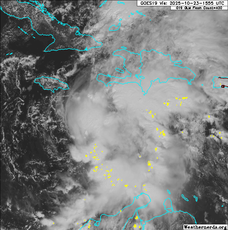
Runaway LLC again, looks like it's due south of the eastern tip of Jamaica now?
3 likes

Re: NATL: MELISSA - Tropical Storm - Discussion
BobHarlem wrote:Runaway LLC again, looks like it's due south of the eastern tip of Jamaica now?
https://i.postimg.cc/2S2Cs3SW/47901760.gif
Looks like it may be at approximately 16N/76.2W, probably rotating within the broader circulation. I have no idea if it’ll tuck back under convection or if a new LLC will establish itself further east.
2 likes
Irene '11 Sandy '12 Hermine '16 5/15/2018 Derecho Fay '20 Isaias '20 Elsa '21 Henri '21 Ida '21
I am only a meteorology enthusiast who knows a decent amount about tropical cyclones. Look to the professional mets, the NHC, or your local weather office for the best information.
I am only a meteorology enthusiast who knows a decent amount about tropical cyclones. Look to the professional mets, the NHC, or your local weather office for the best information.
-
cheezyWXguy

- Category 5
- Posts: 6282
- Joined: Mon Feb 13, 2006 12:29 am
- Location: Dallas, TX
Re: NATL: MELISSA - Tropical Storm - Discussion
aspen wrote:BobHarlem wrote:Runaway LLC again, looks like it's due south of the eastern tip of Jamaica now?
https://i.postimg.cc/2S2Cs3SW/47901760.gif
Looks like it may be at approximately 16N/76.2W, probably rotating within the broader circulation. I have no idea if it’ll tuck back under convection or if a new LLC will establish itself further east.
Yeah it’s hard to tell if that’s an eddy orbiting the parent surface circulation or if the mlc is doing the heavy lifting at the moment. Either way the whole cloud canopy seems to be revolving around a common point east of that swirl. With the persistent deep convection in that eastern area I imagine something will happen at the surface there eventually if it hasn’t already.
3 likes

Re: NATL: MELISSA - Tropical Storm - Discussion
aspen wrote:BobHarlem wrote:Runaway LLC again, looks like it's due south of the eastern tip of Jamaica now?
https://i.postimg.cc/2S2Cs3SW/47901760.gif
Looks like it may be at approximately 16N/76.2W, probably rotating within the broader circulation. I have no idea if it’ll tuck back under convection or if a new LLC will establish itself further east.
Imagine of the number of new LLCs that Melissa forms in its lifetime ends up greater than its peak category number on the SSHWS...
0 likes
TC naming lists: retirements and intensity
Most aggressive Advisory #1's in North Atlantic (cr. kevin for starting the list)
Most aggressive Advisory #1's in North Atlantic (cr. kevin for starting the list)
Re: NATL: MELISSA - Tropical Storm - Discussion
I don't think the feature running away is the LLC.
1 likes
Re: NATL: MELISSA - Tropical Storm - Discussion
I expect the 5pm track will shift a little north, showing either a grazing blow or a direct landfall on Jamaica. I really hope the NHC puts out Hurricane Warnings this advisory.
0 likes
Irene '11 Sandy '12 Hermine '16 5/15/2018 Derecho Fay '20 Isaias '20 Elsa '21 Henri '21 Ida '21
I am only a meteorology enthusiast who knows a decent amount about tropical cyclones. Look to the professional mets, the NHC, or your local weather office for the best information.
I am only a meteorology enthusiast who knows a decent amount about tropical cyclones. Look to the professional mets, the NHC, or your local weather office for the best information.

Re: RE: Re: NATL: MELISSA - Tropical Storm - Discussion
jlauderdal wrote:Don't discount the effect Jamaica's terrain may have on the intensity and rainfall totals..slow mover can have inflow issues,slow mover mountains yields big rain totals, hurricanes don't like land so they can meander around land masses in spite of the mean flow. There are lots of very sturdy structures that have survived majors, there are lots of zinc roofs too.kevin wrote:At first I thought a Jamaica landfall could prevent Melissa from becoming "too strong" (aka a cat 1 or less) before it inevitably strikes a populated area. But with that latest model cycle showing a cat 4/5 Jamaica landfall, I fear we're looking at a lose/lose and it'll be catastrophic no matter what happens. Maybe the best case scenario is a bombing out phase south of Jamaica and missing the island followed by EWRCs weakening Melissa.
Beryl last year simply refused to make landfall on Jamaica. Could easily see something similar here.
1 likes
Igor 2010, Sandy 2012, Fay 2014, Gonzalo 2014, Joaquin 2015, Nicole 2016, Humberto 2019, Imelda 2025
I am only a tropical weather enthusiast. My predictions are not official and may or may not be backed by sound meteorological data. For official information, please refer to the NHC and NWS products.
I am only a tropical weather enthusiast. My predictions are not official and may or may not be backed by sound meteorological data. For official information, please refer to the NHC and NWS products.
Re: NATL: MELISSA - Tropical Storm - Discussion
I checked the coordinates as Gilbert passed over Jamaica:
It went from 17.6N, 75.3W to 18.3N, 78.5W over a 12 hour period. Per a lat/long mileage calculator, that’s 216 statute miles, which means a brisk 18 mph. That’s a whopping 6 times faster than the very slow average of 3 mph that Melissa is forecasted to move by the 11AM NHC advisory while adjacent to Jamaica! So, Gilbert held onto its strength while moving right over it at 18 mph.
How would Melissa do moving a mere 3 mph but just south of the island? I don’t see how it wouldn’t weaken some, possibly significantly, at some point during that 48 hour period even if not immediately due to drier inflow from Jamaica.
Opinions?
0 likes
Personal Forecast Disclaimer:
The posts in this forum are NOT official forecasts and should not be used as such. They are just the opinion of the poster and may or may not be backed by sound meteorological data. They are NOT endorsed by any professional institution or storm2k.org. For official information, please refer to the NHC and NWS products.
The posts in this forum are NOT official forecasts and should not be used as such. They are just the opinion of the poster and may or may not be backed by sound meteorological data. They are NOT endorsed by any professional institution or storm2k.org. For official information, please refer to the NHC and NWS products.
-
MGC

- S2K Supporter
- Posts: 5941
- Joined: Sun Mar 23, 2003 9:05 pm
- Location: Pass Christian MS, or what is left.
Re: NATL: MELISSA - Tropical Storm - Discussion
Interesting to read the next discussion on Melissa from the NHC. Appears the TC is quite disorganized ATM......MGC
0 likes
Re: NATL: MELISSA - Tropical Storm - Discussion
zzzh wrote:New forecast calls for a 125kt peak.
I suspect there is a lot of uncertainty at days 4 and 5 because it depends on how close the storm gets to Jamaica and thus how much land interaction will affect it. Jamaica is quite mountainous so if the core came ashore there I would expect it to get somewhat disrupted and weakened, especially with the forecast slow movement.
1 likes
-
CrazyC83
- Professional-Met

- Posts: 34316
- Joined: Tue Mar 07, 2006 11:57 pm
- Location: Deep South, for the first time!
Re: NATL: MELISSA - Tropical Storm - Discussion
al78 wrote:zzzh wrote:New forecast calls for a 125kt peak.
I suspect there is a lot of uncertainty at days 4 and 5 because it depends on how close the storm gets to Jamaica and thus how much land interaction will affect it. Jamaica is quite mountainous so if the core came ashore there I would expect it to get somewhat disrupted and weakened, especially with the forecast slow movement.
I know Sandy didn't weaken at all over Jamaica, but it was moving at a decent clip.
0 likes
-
CrazyC83
- Professional-Met
- Posts: 34316
- Joined: Tue Mar 07, 2006 11:57 pm
- Location: Deep South, for the first time!
Re: NATL: MELISSA - Tropical Storm - Discussion
Teban54 wrote:kevin wrote:At first I thought a Jamaica landfall could prevent Melissa from becoming "too strong" (aka a cat 1 or less) before it inevitably strikes a populated area. But with that latest model cycle showing a cat 4/5 Jamaica landfall, I fear we're looking at a lose/lose and it'll be catastrophic no matter what happens. Maybe the best case scenario is a bombing out phase south of Jamaica and missing the island followed by EWRCs weakening Melissa.
The best-case scenario for Melissa's impacts seems to be a Delta-esque collapse, from a pinhole Cat 4 to a weakening Cat 2 at its Yucatan landfall (that didn't even warrant retirement).
Absent that... Yeah, Melissa will most likely wreck havoc on someone no matter what, even if the target is unclear.
But if it does a loop around Jamaica staying south and west, it likely hits Cuba as a monster hurricane. It would be far enough away from Jamaica in that case that land interaction would not be a factor - and those runs send the intensity to the stratosphere (a lot of sub-900 scenarios there).
2 likes
-
MGC
- S2K Supporter
- Posts: 5941
- Joined: Sun Mar 23, 2003 9:05 pm
- Location: Pass Christian MS, or what is left.
Re: NATL: MELISSA - Tropical Storm - Discussion
Lets hope Melissa tracks directly over Jamaica and don't achieve Cat-4-5 intensity......MGC
0 likes

Re: NATL: MELISSA - Tropical Storm - Discussion
I am seeing her out pacing the convection. I see it at around 16N 76.4W. Maybe it is a vort.
https://www.tropicaltidbits.com/sat/satlooper.php?region=13L&product=vis
https://www.tropicaltidbits.com/sat/satlooper.php?region=13L&product=vis
0 likes
The following post is NOT an official forecast and should not be used as such. It is just the opinion of the poster and may or may not be backed by sound meteorological data. It is NOT endorsed by any professional institution including storm2k.org For Official Information please refer to the NHC and NWS products.

Re: NATL: MELISSA - Tropical Storm - Discussion
al78 wrote:zzzh wrote:New forecast calls for a 125kt peak.
I suspect there is a lot of uncertainty at days 4 and 5 because it depends on how close the storm gets to Jamaica and thus how much land interaction will affect it. Jamaica is quite mountainous so if the core came ashore there I would expect it to get somewhat disrupted and weakened, especially with the forecast slow movement.
For sure! In fact, I have a theory that Melissa will actually track between WSW and SW by around day 3. Looking at both EURO & GFS 500 MB vorticity forecasts for that period, they both imply a seemingly distinct steering flow from the northeast as a result of the W. Gulf ridging that soon expands eastward through S. Florida and the W Bahamas. In fact, the forecast ridging was discussed in the Discussion as well as by Levi; both instances suggested that a west motion should then ensue.
My two questions are:
- Given the 500mb flow depicted at that time by both Global models, why was there no suggestion or thought that a South of west track might occur?
- My biggest question however is given the forecast influence of the ridge building north of Mellisa, was the westward track and speed over the 2-3 day period so negligible (seemingly near or under 5 mph)?
(Appologies for the model related questions in this thread but was in direct response to the prior post)
1 likes
Andy D
(For official information, please refer to the NHC and NWS products.)
(For official information, please refer to the NHC and NWS products.)
-
Hurricane Mike
- Category 2

- Posts: 675
- Joined: Tue Apr 10, 2018 7:44 am
Re: NATL: MELISSA - Tropical Storm - Discussion
5:30pm Video Update on Melissa
https://www.youtube.com/watch?v=IBNUWOYoLIw
https://www.youtube.com/watch?v=IBNUWOYoLIw
0 likes
Who is online
Users browsing this forum: No registered users and 74 guests