NATL: MELISSA - Aftermath - Discussion
Moderator: S2k Moderators
Re: NATL: MELISSA - Tropical Storm - Discussion
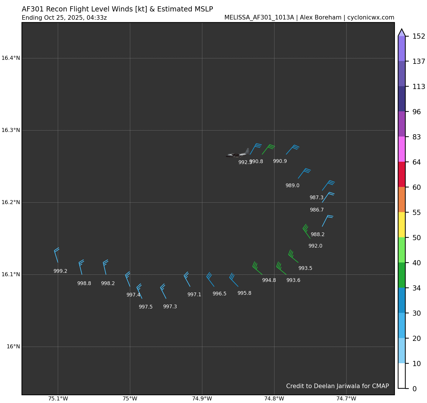
Extrap pressure down to 986.7mb! I did not see that coming
7 likes
-
TomballEd
- Category 5

- Posts: 1318
- Age: 62
- Joined: Wed Aug 16, 2023 4:52 pm
- Location: Spring/Klein area, not Tomball
Re: NATL: MELISSA - Tropical Storm - Discussion
zzzh wrote:Extrap pressure down to 986.7mb! I did not see that coming
Where did you see that?
Edit to add: bedtime. See y'all tomorrow.
2 likes
-
Iceresistance

- Category 5
- Posts: 9606
- Age: 22
- Joined: Sat Oct 10, 2020 9:45 am
- Location: Tecumseh, OK/Norman, OK
Re: NATL: MELISSA - Tropical Storm - Discussion
7 likes
Bill 2015 & Beta 2020
Winter 2020-2021
All observations are in Tecumseh, OK unless otherwise noted.
Winter posts are focused mainly for Oklahoma & Texas.
Take any of my forecasts with a grain of salt, refer to the NWS, SPC, and NHC for official information
Never say Never with weather! Because ANYTHING is possible!
Winter 2020-2021
All observations are in Tecumseh, OK unless otherwise noted.
Winter posts are focused mainly for Oklahoma & Texas.
Take any of my forecasts with a grain of salt, refer to the NWS, SPC, and NHC for official information
Never say Never with weather! Because ANYTHING is possible!
-
cheezyWXguy

- Category 5
- Posts: 6282
- Joined: Mon Feb 13, 2006 12:29 am
- Location: Dallas, TX
Re: NATL: MELISSA - Tropical Storm - Discussion
Iceresistance wrote:986.7 extrapolated, goodness
https://s12.gifyu.com/images/b3daJ.png
https://s12.gifyu.com/images/b3daJ.png
That’s a pretty solid jump. It does coincide with the rebound in appearance on satellite though. What really surprises me though is that the pressure can drop that low with FL winds of less than 40kt
5 likes
-
ElectricStorm

- Category 5
- Posts: 5154
- Age: 25
- Joined: Tue Aug 13, 2019 11:23 pm
- Location: Norman, OK
Re: NATL: MELISSA - Tropical Storm - Discussion
Drop 989/27, supports 986-987mb. Looks to be ramping up, probably for real this time
2 likes
B.S Meteorology, University of Oklahoma '25
Please refer to the NHC, NWS, or SPC for official information.
Please refer to the NHC, NWS, or SPC for official information.
-
WaveBreaking

- Category 2

- Posts: 728
- Joined: Sun Jun 30, 2024 11:33 am
- Location: US
Re: NATL: MELISSA - Tropical Storm - Discussion
Yet another shockwave from the CDO. Not as dramatic as the first one but still there.

3 likes
I am NOT a professional meteorologist, so take all of my posts with a grain of salt. My opinions are mine and mine alone.

Re: NATL: MELISSA - Tropical Storm - Discussion
Simply looking at the CDO (especially in comparison to the last few days), i'm half expecting to suddenly see an eye appear in the next satellite frame smack in the dead middle of it. I'll say this much, it's symmetrical and small shape makes me think of Hurricane Andrew.
3 likes
Andy D
(For official information, please refer to the NHC and NWS products.)
(For official information, please refer to the NHC and NWS products.)
Re: NATL: MELISSA - Tropical Storm - Discussion
One other quick take. Watching this storm for the last 2 days has felt like watching and waiting for an unfertilized egg to hatch.
0 likes
Andy D
(For official information, please refer to the NHC and NWS products.)
(For official information, please refer to the NHC and NWS products.)

Re: NATL: MELISSA - Tropical Storm - Discussion
6z Best Track:
AL, 13, 2025102506, , BEST, 0, 163N, 749W, 60, 986, TS...
0 likes


Re: NATL: MELISSA - Tropical Storm - Discussion
Looks like a "CCC" pattern in Melissa. The GFS's solution is becoming reality, fortunately for Jamaica
0 likes

Re: NATL: MELISSA - Tropical Storm - Discussion
The average CDO temperature has fallen from -65C to -70C within the last 60 minutes. The eyewall is also becoming visible on IR as even colder cloudtops within the CDO. Not sure when I've seen that for the last time. If Melissa is gonna follow those crazy model runs this is when it needs to happen. Let's see what happens, recon is on its way.
1 likes
Re: NATL: MELISSA - Tropical Storm - Discussion
Dry air from the bottom of the trof is quickly being filled in with moist air.
https://www.tropicaltidbits.com/sat/sat ... uct=wv_mid
https://www.tropicaltidbits.com/sat/sat ... uct=wv_mid
0 likes
-
jlauderdal
- S2K Supporter

- Posts: 7240
- Joined: Wed May 19, 2004 5:46 am
- Location: NE Fort Lauderdale
- Contact:
Re: NATL: MELISSA - Tropical Storm - Discussion
GCANE wrote:Dry air from the bottom of the trof is quickly being filled in with moist air.
https://www.tropicaltidbits.com/sat/sat ... uct=wv_mid
Classic Fall setup, look at the flow working on the system keeping it pinned. This was a blockbuster Gulf system two weeks late.
1 likes

Re: NATL: MELISSA - Tropical Storm - Discussion
Definitely moving west now. Incredibly cold cloud tops in CDO. She should RI today.
0 likes
-
cycloneye

- Admin

- Posts: 149703
- Age: 69
- Joined: Thu Oct 10, 2002 10:54 am
- Location: San Juan, Puerto Rico
Re: NATL: MELISSA - Tropical Storm - Discussion
Peak Flight-Level Winds: 68kt at 10:47z
Minimum Extrap. Pressure: 985.3mb at 10:50z
Minimum Extrap. Pressure: 985.3mb at 10:50z
2 likes
Visit the Caribbean-Central America Weather Thread where you can find at first post web cams,radars
and observations from Caribbean basin members Click Here
and observations from Caribbean basin members Click Here

Re: NATL: MELISSA - Tropical Storm - Discussion
ronjon wrote:Definitely moving west now. Incredibly cold cloud tops in CDO. She should RI today.
Recon mission is checking this morning, flying west near 16.18N
Both 00z GFS and ECM have her gaining a little more latitude before a WSW slide into the blue mountains.
Only the UKMET is still showing a hook NE over western Jamaica and that is as the weak storm outlier.
100 year flood map could help officials with evacuation but Jamaican politics being what they are.
0 likes
Re: NATL: MELISSA - Tropical Storm - Discussion
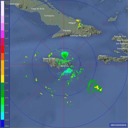
A bit easier to see on radar this morning. (note the mountains cut off angles of the radar there)
4 likes
-
Deshaunrob17
- Tropical Storm

- Posts: 211
- Joined: Tue Aug 18, 2020 7:49 am
Re: NATL: MELISSA - Tropical Storm - Discussion
This is going to be just an easy heavy system ( assuming due to westerly shear) that the hurricane could make landfall in east/ central Jamaica and barely impacts west Jamaica. Meanwhile in these scenarios even Haiti gets hammered with rain bands
0 likes
Who is online
Users browsing this forum: No registered users and 105 guests