NATL: MELISSA - Aftermath - Discussion
Moderator: S2k Moderators
-
galaxy401

- Category 5

- Posts: 2446
- Age: 30
- Joined: Sat Aug 25, 2012 9:04 pm
- Location: Casa Grande, Arizona
Re: NATL: MELISSA - Hurricane - Discussion
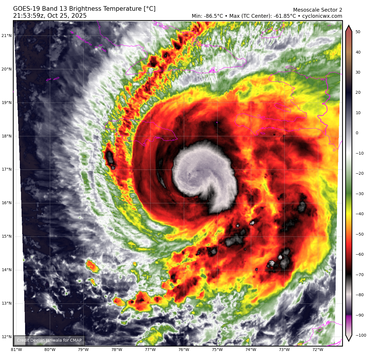
This appears to be an unprecedented hurricane in the making. A monster category 5 that will be crawling towards Jamaica. The closest analogy I can think of is the 1932 Cuba hurricane: Late season, very powerful storm that was crawling the Caribbean. Though that one missed Jamaica.
2 likes
Got my eyes on moving right into Hurricane Alley: Florida.
-
Iceresistance

- Category 5
- Posts: 9608
- Age: 22
- Joined: Sat Oct 10, 2020 9:45 am
- Location: Tecumseh, OK/Norman, OK
Re: NATL: MELISSA - Hurricane - Discussion
That VHT has literally left behind a comma, that was one insane VHT
https://s12.gifyu.com/images/b3nnI.png
https://s12.gifyu.com/images/b3nnI.png
8 likes
Bill 2015 & Beta 2020
Winter 2020-2021
All observations are in Tecumseh, OK unless otherwise noted.
Winter posts are focused mainly for Oklahoma & Texas.
Take any of my forecasts with a grain of salt, refer to the NWS, SPC, and NHC for official information
Never say Never with weather! Because ANYTHING is possible!
Winter 2020-2021
All observations are in Tecumseh, OK unless otherwise noted.
Winter posts are focused mainly for Oklahoma & Texas.
Take any of my forecasts with a grain of salt, refer to the NWS, SPC, and NHC for official information
Never say Never with weather! Because ANYTHING is possible!
-
Hypercane_Kyle

- Category 5
- Posts: 3465
- Joined: Sat Mar 07, 2015 7:58 pm
- Location: Cape Canaveral, FL
Re: NATL: MELISSA - Hurricane - Discussion
Hard to think of a way this could come in at a worse angle too... worst of the storm and surge will be piling right into Kingston. 1.19 million people will be under the worst of a Category 5 hurricane that is crawling.
2 likes
My posts are my own personal opinion, defer to the National Hurricane Center (NHC) and other NOAA products for decision making during hurricane season.
-
Blown Away

- S2K Supporter

- Posts: 10253
- Joined: Wed May 26, 2004 6:17 am
Re: NATL: MELISSA - Hurricane - Discussion
Hypercane_Kyle wrote:Hard to think of a way this could come in at a worse angle too... worst of the storm and surge will be piling right into Kingston. 1.19 million people will be under the worst of a Category 5 hurricane that is crawling.
Terrible, as close as Melissa is now, it’s literally 2-3 days from landfall!

1 likes
Hurricane Eye Experience: David 79, Irene 99, Frances 04, Jeanne 04, Wilma 05… Hurricane Brush Experience: Andrew 92, Erin 95, Floyd 99, Matthew 16, Irma 17, Ian 22, Nicole 22…
-
USTropics
- Professional-Met

- Posts: 2741
- Joined: Sun Aug 12, 2007 3:45 am
- Location: Florida State University
Re: NATL: MELISSA - Hurricane - Discussion
Iceresistance wrote:That VHT has literally left behind a comma, that was one insane VHT
https://s12.gifyu.com/images/b3nnI.png
https://s12.gifyu.com/images/b3nnI.png
Yea it literally rotated upshear, so much energy was being transported it was creating radial mesoscale-gravity waves. Basically the vertical transport of momentum and heat becomes asymmetric, and these rapid changes radiate outward as concentric ripples/wave-like bands emanating from the storm core we see here as the sun goes down. This definitely has been rapidly intensifying:

9 likes
-
ScottNAtlanta

- Category 5
- Posts: 2535
- Joined: Sat May 25, 2013 3:11 pm
- Location: Atlanta, GA
Re: NATL: MELISSA - Hurricane - Discussion
Recon is moving into lower altitude, so it wont be long before we know how much Melissa has strengthened.
0 likes
The posts in this forum are NOT official forecast and should not be used as such. They are just the opinion of the poster and may or may not be backed by sound meteorological data. They are NOT endorsed by any professional institution or storm2k.org. For official information, please refer to the NHC and NWS products.


Re: NATL: MELISSA - Hurricane - Discussion
Not sure what NOAA2 is doing. They’re zig zagging across the southern coast of Jamaica. Perhaps they’ve been called for search and rescue?
Edit, nvm, looks like they’re heading in now.
Edit, nvm, looks like they’re heading in now.
Last edited by aspen on Sat Oct 25, 2025 5:31 pm, edited 1 time in total.
2 likes
Irene '11 Sandy '12 Hermine '16 5/15/2018 Derecho Fay '20 Isaias '20 Elsa '21 Henri '21 Ida '21
I am only a meteorology enthusiast who knows a decent amount about tropical cyclones. Look to the professional mets, the NHC, or your local weather office for the best information.
I am only a meteorology enthusiast who knows a decent amount about tropical cyclones. Look to the professional mets, the NHC, or your local weather office for the best information.
-
Hurricane2022

- Category 5
- Posts: 2093
- Joined: Tue Aug 23, 2022 11:38 pm
- Location: Araçatuba, Brazil
Re: NATL: MELISSA - Hurricane - Discussion
2 likes
Sorry for the bad English sometimes...!
For reliable and detailed information for any meteorological phenomenon, please consult the National Hurricane Center, Joint Typhoon Warning Center , or your local Meteo Center.
--------
ECCE OMNIA NOVA FACIAM (Ap 21,5).
For reliable and detailed information for any meteorological phenomenon, please consult the National Hurricane Center, Joint Typhoon Warning Center , or your local Meteo Center.
--------
ECCE OMNIA NOVA FACIAM (Ap 21,5).

-
ScottNAtlanta
- Category 5
- Posts: 2535
- Joined: Sat May 25, 2013 3:11 pm
- Location: Atlanta, GA
Re: NATL: MELISSA - Hurricane - Discussion
Last edited by ScottNAtlanta on Sat Oct 25, 2025 5:34 pm, edited 1 time in total.
2 likes
The posts in this forum are NOT official forecast and should not be used as such. They are just the opinion of the poster and may or may not be backed by sound meteorological data. They are NOT endorsed by any professional institution or storm2k.org. For official information, please refer to the NHC and NWS products.
-
TallyTracker
- Category 2

- Posts: 787
- Joined: Thu Oct 11, 2018 2:46 pm
Re: NATL: MELISSA - Hurricane - Discussion
The northeasterly flow over Jamaica’s mountains is already inducing rain. 3-4 more days or torrential rains followed by intense winds is nearly the worst case storm I can imagine. I’m thinking my 115 - 125 kts estimate of peak intensity in the poll is going to be very underdone.
2 likes
Fran '96, Georges '98, Gordon '00, Gabrielle '01, Charley '04, Frances '04, Jeanne '04, Barry '07, Fay '08, Debby '12, Matthew '16, Emily '17, Irma '17, Michael ‘18, Elsa ‘21, Fred ‘21, Mindy ‘21, Nicole ‘22, Idalia ‘23, Debby ‘24, Helene ‘24
-
KirbyDude25

- Tropical Storm

- Posts: 162
- Age: 21
- Joined: Mon Sep 20, 2021 8:03 am
- Location: Westfield, New Jersey
Re: NATL: MELISSA - Hurricane - Discussion
aspen wrote:Not sure what NOAA2 is doing. They’re zig zagging across the southern coast of Jamaica. Perhaps they’ve been called for search and rescue?
Edit, nvm, looks like they’re heading in now.
They were deploying a drone (both of today's NOAA flights with TDR did this)
3 likes
New Jersey, Rutgers '27
Irene 2011 | Sandy 2012 | Fay 2020 | Isaias 2020 | Ida 2021
Irene 2011 | Sandy 2012 | Fay 2020 | Isaias 2020 | Ida 2021

Re: NATL: MELISSA - Hurricane - Discussion
Yes and seems to be moving faster. Hopefull gets far enough west to limit impact on Jamaica even after NE turn.
1 likes
The following post is NOT an official forecast and should not be used as such. It is just the opinion of the poster and may or may not be backed by sound meteorological data. It is NOT endorsed by any professional institution including storm2k.org For Official Information please refer to the NHC and NWS products.
-
Hypercane_Kyle
- Category 5
- Posts: 3465
- Joined: Sat Mar 07, 2015 7:58 pm
- Location: Cape Canaveral, FL
Re: NATL: MELISSA - Hurricane - Discussion
The eye will bounce around significantly as the storm explosively intensifies.
3 likes
My posts are my own personal opinion, defer to the National Hurricane Center (NHC) and other NOAA products for decision making during hurricane season.
-
WaveBreaking

- Category 2
- Posts: 728
- Joined: Sun Jun 30, 2024 11:33 am
- Location: US
Re: NATL: MELISSA - Hurricane - Discussion
The current set of VHTs is so tall that sunlight is still hitting them.

9 likes
I am NOT a professional meteorologist, so take all of my posts with a grain of salt. My opinions are mine and mine alone.
-
Hurricane2022
- Category 5
- Posts: 2093
- Joined: Tue Aug 23, 2022 11:38 pm
- Location: Araçatuba, Brazil
Re: NATL: MELISSA - Hurricane - Discussion
ERI may have started now. Recon already reporting 87 kt FL. The eye should appear soon.
4 likes
Sorry for the bad English sometimes...!
For reliable and detailed information for any meteorological phenomenon, please consult the National Hurricane Center, Joint Typhoon Warning Center , or your local Meteo Center.
--------
ECCE OMNIA NOVA FACIAM (Ap 21,5).
For reliable and detailed information for any meteorological phenomenon, please consult the National Hurricane Center, Joint Typhoon Warning Center , or your local Meteo Center.
--------
ECCE OMNIA NOVA FACIAM (Ap 21,5).
-
CrazyC83
- Professional-Met
- Posts: 34316
- Joined: Tue Mar 07, 2006 11:57 pm
- Location: Deep South, for the first time!
Re: NATL: MELISSA - Hurricane - Discussion
Hurricane2022 wrote:ERI may have started now. Recon already reporting 87 kt FL. The eye should appear soon.
That's in the back side of the storm too, although the slow motion likely reduces the differences between the quads. That would on its own support the current 80 kt intensity - and they haven't reached the eyewall yet.
4 likes


Re: NATL: MELISSA - Hurricane - Discussion
Hurricane2022 wrote:ERI may have started now. Recon already reporting 87 kt FL. The eye should appear soon.
I'll wait for an extreme pressure drop between passes or visual cues like vigorous lightning surrounding the eyewall / eye clearing out on satellite imagery before I say "ERI", but that's mincing words....little doubt at this point that Melissa is intensifying fast. Just a question of how fast.
1 likes
Who is online
Users browsing this forum: No registered users and 28 guests