
What also often happens is "stair-stepping": Pressure drops first, then wind catches up, then pressure drops again, etc.
NATL: MELISSA - Aftermath - Discussion
Moderator: S2k Moderators
Re: NATL: MELISSA - Hurricane - Discussion
What also often happens is "stair-stepping": Pressure drops first, then wind catches up, then pressure drops again, etc.
5 likes
TC naming lists: retirements and intensity
Most aggressive Advisory #1's in North Atlantic (cr. kevin for starting the list)
Most aggressive Advisory #1's in North Atlantic (cr. kevin for starting the list)
-
cheezyWXguy

- Category 5

- Posts: 6282
- Joined: Mon Feb 13, 2006 12:29 am
- Location: Dallas, TX
Re: NATL: MELISSA - Hurricane - Discussion
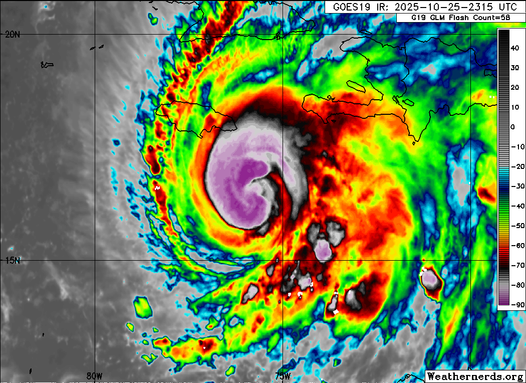
Haven’t had much chance to watch this thing since about 1pm. Wow what a dramatic change in strength and appearance. The leveling off in pressure is clearly temporary. I don’t think I’m gonna get much sleep tonight watching this evolve lol.
5 likes

Re: NATL: MELISSA - Hurricane - Discussion
I've never seen these "jagged" features that are on the SW side of the CDO and inner bands. It's not "ragged" like a struggling system would be, but more like aggressive spikes of energy radiating outwards.

8 likes
Igor 2010, Sandy 2012, Fay 2014, Gonzalo 2014, Joaquin 2015, Nicole 2016, Humberto 2019, Imelda 2025
I am only a tropical weather enthusiast. My predictions are not official and may or may not be backed by sound meteorological data. For official information, please refer to the NHC and NWS products.
I am only a tropical weather enthusiast. My predictions are not official and may or may not be backed by sound meteorological data. For official information, please refer to the NHC and NWS products.
-
Iceresistance

- Category 5
- Posts: 9607
- Age: 22
- Joined: Sat Oct 10, 2020 9:45 am
- Location: Tecumseh, OK/Norman, OK
Re: NATL: MELISSA - Hurricane - Discussion
4 likes
Bill 2015 & Beta 2020
Winter 2020-2021
All observations are in Tecumseh, OK unless otherwise noted.
Winter posts are focused mainly for Oklahoma & Texas.
Take any of my forecasts with a grain of salt, refer to the NWS, SPC, and NHC for official information
Never say Never with weather! Because ANYTHING is possible!
Winter 2020-2021
All observations are in Tecumseh, OK unless otherwise noted.
Winter posts are focused mainly for Oklahoma & Texas.
Take any of my forecasts with a grain of salt, refer to the NWS, SPC, and NHC for official information
Never say Never with weather! Because ANYTHING is possible!
Re: NATL: MELISSA - Hurricane - Discussion
You can just tell this is an absolute beast in the making. Melissa...another M baddie...looks to be the bad one of the 25 season
5 likes

Re: NATL: MELISSA - Hurricane - Discussion
If it goes more south and west, could the next front miss lifting it out to sea?
1 likes
-
CrazyC83
- Professional-Met

- Posts: 34316
- Joined: Tue Mar 07, 2006 11:57 pm
- Location: Deep South, for the first time!
Re: NATL: MELISSA - Hurricane - Discussion
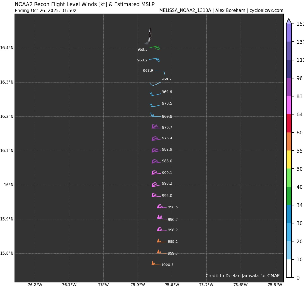
zzzh wrote:750mb FL 111kt!This would support 95-100kt
If that was at 700, this would be a major. But even still I agree 95 kt is the best estimate for the intensity.
1 likes

Re: NATL: MELISSA - Hurricane - Discussion
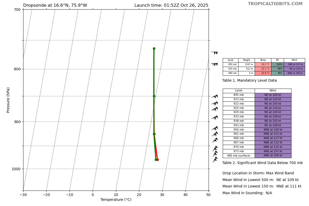
Latest dropsonde has >100 kt winds down the whole profile
2 likes
-
CrazyC83
- Professional-Met
- Posts: 34316
- Joined: Tue Mar 07, 2006 11:57 pm
- Location: Deep South, for the first time!
Re: NATL: MELISSA - Hurricane - Discussion
ljmac75 wrote:Latest dropsonde has >100 kt winds down the whole profile
I saw it with 106 kt at the surface. I wonder if it is accurate? Or a bit overdone?
0 likes
Re: NATL: MELISSA - Hurricane - Discussion
ljmac75 wrote:Latest dropsonde has >100 kt winds down the whole profile
6 likes
TC naming lists: retirements and intensity
Most aggressive Advisory #1's in North Atlantic (cr. kevin for starting the list)
Most aggressive Advisory #1's in North Atlantic (cr. kevin for starting the list)

Re: NATL: MELISSA - Hurricane - Discussion
CrazyC83 wrote:ljmac75 wrote:Latest dropsonde has >100 kt winds down the whole profile
I saw it with 106 kt at the surface. I wonder if it is accurate? Or a bit overdone?
If it’s not accurate right now, it likely will be within an hour or so. Melissa is looking to be a hell of a monster over the next 24 hours unless an eye wall replacement cycle knocks her down, but even then I’m not sure how long that will be, especially if it goes through an eye wall meld instead.
1 likes

Re: NATL: MELISSA - Hurricane - Discussion
Teban54 wrote:ljmac75 wrote:Latest dropsonde has >100 kt winds down the whole profile
https://i.postimg.cc/Gh1BhvXb/recon-NOAA2-1313A-MELISSA-dropsonde20-20251026-0152.png
From that N eyewall dropsonde the WL150 winds support 95kts just like the FL winds do. Melissa is knocking at the door of MH strength.
0 likes
-
CrazyC83
- Professional-Met
- Posts: 34316
- Joined: Tue Mar 07, 2006 11:57 pm
- Location: Deep South, for the first time!
Re: NATL: MELISSA - Hurricane - Discussion
Combined with the SFMR, likely around 105 kt. Pressure looks to be way down this pass too, maybe 964 or so?
6 likes
-
Hurricane2022

- Category 5
- Posts: 2092
- Joined: Tue Aug 23, 2022 11:38 pm
- Location: Araçatuba, Brazil
Re: NATL: MELISSA - Hurricane - Discussion
Habemus Major Hurricane Melissa. I'll wait for the next NHC advisory before going to bed...but as of now, I expect to wake up to an apocalyptic hurricane with winds of 140-160+ mph.
zzzh wrote:700mb FL 115! Easily a MH.
Last edited by Hurricane2022 on Sat Oct 25, 2025 9:38 pm, edited 1 time in total.
2 likes
Sorry for the bad English sometimes...!
For reliable and detailed information for any meteorological phenomenon, please consult the National Hurricane Center, Joint Typhoon Warning Center , or your local Meteo Center.
--------
ECCE OMNIA NOVA FACIAM (Ap 21,5).
For reliable and detailed information for any meteorological phenomenon, please consult the National Hurricane Center, Joint Typhoon Warning Center , or your local Meteo Center.
--------
ECCE OMNIA NOVA FACIAM (Ap 21,5).
Re: NATL: MELISSA - Hurricane - Discussion
115kt 700mb winds plus 108kt SFMR blends and rounds to 105kt and extrap pressure so far is down to 966mb with 20kts wind—we'll see if the next HDOB dump has a bit lower. Regardless I expect to see a MH at the 03z advisory.
Also an interesting note from the last VDM, I'm not sure if this has any implication on intensification as I've never seen it before:
Also an interesting note from the last VDM, I'm not sure if this has any implication on intensification as I've never seen it before:
EYEWALL APPEARS SQUARE ON RADAR SIGNATURE
5 likes
-
Hypercane_Kyle

- Category 5
- Posts: 3465
- Joined: Sat Mar 07, 2015 7:58 pm
- Location: Cape Canaveral, FL
Re: NATL: MELISSA - Hurricane - Discussion
Jeez, Melissa will likely be approaching or at Cat 4 by sunrise at this rate.
0 likes
My posts are my own personal opinion, defer to the National Hurricane Center (NHC) and other NOAA products for decision making during hurricane season.
-
Blown Away

- S2K Supporter

- Posts: 10253
- Joined: Wed May 26, 2004 6:17 am
Re: NATL: MELISSA - Hurricane - Discussion
FORECAST POSITIONS AND MAX WINDS
5pm
INIT 25/2100Z 16.6N 75.5W 80 KT 90 MPH
12H 26/0600Z 16.7N 75.9W 100 KT 115 MPH
24H 26/1800Z 16.7N 76.5W 115 KT 130 MPH
36H 27/0600Z 16.7N 77.2W 135 KT 155 MPH
48H 27/1800Z 16.9N 77.6W 140 KT 160 MPH
60H 28/0600Z 17.6N 77.4W 130 KT 150 MPH
72H 28/1800Z 18.8N 76.7W 115 KT 130 MPH
96H 29/1800Z 22.0N 73.4W 90 KT 105 MPH
120H 30/1800Z 27.0N 69.0W 80 KT 90 MPH
Melissa not supposed to pass 76W until after 06z, my guess she’s pretty close now. I think W adjustments now will result in W adjustments near Jamaica… JMHO
5 likes
Hurricane Eye Experience: David 79, Irene 99, Frances 04, Jeanne 04, Wilma 05… Hurricane Brush Experience: Andrew 92, Erin 95, Floyd 99, Matthew 16, Irma 17, Ian 22, Nicole 22…
Who is online
Users browsing this forum: No registered users and 41 guests