NATL: MELISSA - Aftermath - Discussion
Moderator: S2k Moderators

Re: NATL: MELISSA - Hurricane - Discussion
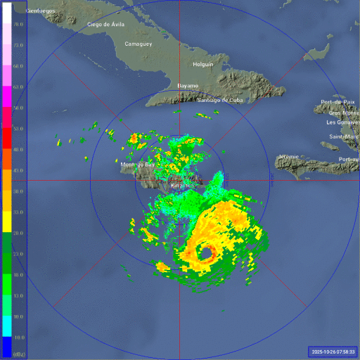
That large band with deep convection to the east is interesting. Must be the “Matthew effect” from being in a similar location at a similar time of year, lol.
1 likes
Igor 2010, Sandy 2012, Fay 2014, Gonzalo 2014, Joaquin 2015, Nicole 2016, Humberto 2019, Imelda 2025
I am only a tropical weather enthusiast. My predictions are not official and may or may not be backed by sound meteorological data. For official information, please refer to the NHC and NWS products.
I am only a tropical weather enthusiast. My predictions are not official and may or may not be backed by sound meteorological data. For official information, please refer to the NHC and NWS products.
-
Hypercane_Kyle

- Category 5

- Posts: 3465
- Joined: Sat Mar 07, 2015 7:58 pm
- Location: Cape Canaveral, FL
Re: NATL: MELISSA - Hurricane - Discussion
I think the size of the eye/pressure gradient resulted in us not seeing Melissa rapidly intensify to a Category 5 overnight, i.e. no pinhole eye. If Melissa had developed a pinhole eye there's no question we'd be looking at 175mph+ Category 5. However, those structures are inherently unstable. Melissa's current structure looks more primed for continued gradual intensification in conjunction with EWRC over the next few days.
4 likes
My posts are my own personal opinion, defer to the National Hurricane Center (NHC) and other NOAA products for decision making during hurricane season.
-
mrbagyo

- Category 5
- Posts: 3998
- Age: 33
- Joined: Thu Apr 12, 2012 9:18 am
- Location: 14.13N 120.98E
- Contact:
Re: NATL: MELISSA - Hurricane - Discussion
Kazmit wrote:That large band with deep convection to the east is interesting. Must be the “Matthew effect” from being in a similar location at a similar time of year, lol.
Could that huge eastern blob of convection hindering the intensification? it appears too "heavy" for small Melissa to carry - like it's dragging the whole circulation not to spin faster.
sort of like a spinning top with uneven weight.
There are very intense storms that had strong spiral bands but their bands look "smooth". Melissa's doesn't look smooth at all
3 likes
The posts in this forum are NOT official forecast and should not be used as such. They are just the opinion of the poster and may or may not be backed by sound meteorological data. They are NOT endorsed by any professional institution or storm2k.org. For official information, please refer to RSMC, NHC and NWS products.
-
hurricaneCW
- Category 5
- Posts: 1799
- Joined: Wed Mar 03, 2010 6:20 am
- Location: Toms River, NJ
Re: NATL: MELISSA - Hurricane - Discussion
Hypercane_Kyle wrote:I think the size of the eye/pressure gradient resulted in us not seeing Melissa rapidly intensify to a Category 5 overnight, i.e. no pinhole eye. If Melissa had developed a pinhole eye there's no question we'd be looking at 175mph+ Category 5. However, those structures are inherently unstable. Melissa's current structure looks more primed for continued gradual intensification in conjunction with EWRC over the next few days.
Huh? It went from a TS to a Cat 4 in like a day. Not sure what else people are looking for here.
5 likes

Re: NATL: MELISSA - Hurricane - Discussion
We now have three consecutive recon passes all supporting a pressure of 952-953 mb with dropsonades. FL winds have also been consistently at 120 kt, supporting an intensity of 110 kt at best. This is despite Melissa having a clear, round eye for hours.
If this continues until 11am EDT -- and that's a big if -- we'll see if NHC will explicitly lower the wind speed from 120 kt that they had at 5am from satellite estimates, and carried over at 8am.
As for why, I have to think shear is part of this. Pretty evident from the loop below.
6z HAFS-A and HAFS-B do show a first peak in wind speed (though not pressure) in the 130-140 kt range today, before a second, even higher peak in both wind and pressure around 150 kt at landfall.
4 likes
TC naming lists: retirements and intensity
Most aggressive Advisory #1's in North Atlantic (cr. kevin for starting the list)
Most aggressive Advisory #1's in North Atlantic (cr. kevin for starting the list)
-
ScottNAtlanta

- Category 5
- Posts: 2535
- Joined: Sat May 25, 2013 3:11 pm
- Location: Atlanta, GA
Re: NATL: MELISSA - Hurricane - Discussion
I want to dispel this thought that a cat 5 requires a pinhole eye. It does not. There is a lot that goes into hurricane dynamics besides the size of the eye


11 likes
The posts in this forum are NOT official forecast and should not be used as such. They are just the opinion of the poster and may or may not be backed by sound meteorological data. They are NOT endorsed by any professional institution or storm2k.org. For official information, please refer to the NHC and NWS products.
-
Hurricane2022

- Category 5
- Posts: 2092
- Joined: Tue Aug 23, 2022 11:38 pm
- Location: Araçatuba, Brazil
Re: NATL: MELISSA - Hurricane - Discussion
2 likes
Sorry for the bad English sometimes...!
For reliable and detailed information for any meteorological phenomenon, please consult the National Hurricane Center, Joint Typhoon Warning Center , or your local Meteo Center.
--------
ECCE OMNIA NOVA FACIAM (Ap 21,5).
For reliable and detailed information for any meteorological phenomenon, please consult the National Hurricane Center, Joint Typhoon Warning Center , or your local Meteo Center.
--------
ECCE OMNIA NOVA FACIAM (Ap 21,5).

Re: NATL: MELISSA - Hurricane - Discussion
1900hurricane wrote:While looking back at some satellite imagery from Maria '17, I noticed an interesting feature around the time of peak intensity. Just before 00Z September 20th, there was a large and cold convective burst near the edge of the CDO (still image below, loop here). I'm not sure this phenomenon has a proper name, so for now, I'm going to call it lobing.
https://www.nrlmry.navy.mil/tcdat/tc2017/AL/AL152017/png/Infrared/201709192330_AL152017_abi_Infrared_80.0_covg100p0_res1km.png
Based on recon data, it appears like it might have coincided with a halt in intensification since the previously falling pressure evened out at 909 mb at the 2219Z pass and only varied by a millibar up and down from that number for the next six hours before rising. This lobing phenomenon could possibly be associated with structural changes. Lobing isn't exclusive to Maria '17 either. It appears it has occurred with a number of intense tropical cyclones across multiple basins. Some of the more clear examples are Nepartak '16, Patricia '15, Usagi '13, and Gilbert '88. Patricia '15 and Gilbert '88 each had recon near the time of lobing (near 18Z October 23rd for Patricia and 00Z September 14th for Gilbert), and both cases were similar to the Maria '17 data which showed no appreciable deepening from that time on. Patricia '15 actually began to weaken rapidly, although land interaction may have played a part in that case. Regardless, it may be a good sign to indicate whether an intense tropical cyclone has peaked.
A quote from 1900hurricane in another thread (Discussion of Intense Tropical Cyclones). This 'lobing' phenomenon also seems to be pressent with Melissa. The big lobe to the east of Melissa prevents her from smoothening out and kinda drags against the rotation of the system. This might be part of the reason (or a symptom of more large-scale structural situation, idk exactly how the 'lobing' phenomenon works) why Melissa isn't really intensifying despite raw T# > 7 for multiple hours. If the lobe persists it might even be a trigger for an EWRC and could thus halt intensification completely. However, since no models show a decrease in wind speed any time soon I'm hesitant to go that far. I think the lobe is simply a temporary cap on Melissa's intensity. The lobe appeared around 5 hours ago and peaked in size about 2 hours ago. It seems to be slowly dissipating now and once it completely disappears within another 2 - 3 hours I expect explosive further intensification. The only good news for Jamaica would be if the lobe manages to take down Melissa's eye with it, but I highly doubt that.
7 likes
-
Hypercane_Kyle
- Category 5
- Posts: 3465
- Joined: Sat Mar 07, 2015 7:58 pm
- Location: Cape Canaveral, FL
Re: NATL: MELISSA - Hurricane - Discussion
ScottNAtlanta wrote:I want to dispel this thought that a cat 5 requires a pinhole eye. It does not. There is a lot that goes into hurricane dynamics besides the size of the eye
https://upload.wikimedia.org/wikipedia/commons/6/6e/Isabel_2003-09-14_1245Z.jpg
https://media.npr.org/assets/img/2018/06/15/gettyimages-843792064_wide-40ed851f4958605f65f2974df45011df5941106c.jpg
That was never implied, but rather when explosive bouts of RI occurs it is very common that pinhole eyes are present, especially for storms of Melissa's size.
2 likes
My posts are my own personal opinion, defer to the National Hurricane Center (NHC) and other NOAA products for decision making during hurricane season.
Re: NATL: MELISSA - Hurricane - Discussion
ScottNAtlanta wrote:I want to dispel this thought that a cat 5 requires a pinhole eye. It does not. There is a lot that goes into hurricane dynamics besides the size of the eye
https://upload.wikimedia.org/wikipedia/commons/6/6e/Isabel_2003-09-14_1245Z.jpg
https://media.npr.org/assets/img/2018/06/15/gettyimages-843792064_wide-40ed851f4958605f65f2974df45011df5941106c.jpg
I'll also add that Rita, a sub-900 and the strongest hurricane in the Gulf (tied with Milton), had an eye even larger than Melissa's right now - very much unlike Milton despite identical peak intensity.
From Rita's TCR:
When the next aircraft arrived, dropwindsondes in the eye measured 898 mb (with a
surface wind of 13 kt) at 0538 UTC and 899 mb (with a surface wind of 35 kt) at 0715 UTC.
[...] the minimum pressure in Rita probably
occurred at about 0300 UTC 22 September and is estimated at 895 mb. [...] The eye diameter as reported by
aircraft contracted from 20 n mi near 0000 UTC to 16 n mi near 0600 UTC, suggesting that
slight strengthening could have occurred during that time.
4 likes
TC naming lists: retirements and intensity
Most aggressive Advisory #1's in North Atlantic (cr. kevin for starting the list)
Most aggressive Advisory #1's in North Atlantic (cr. kevin for starting the list)
-
ScottNAtlanta
- Category 5
- Posts: 2535
- Joined: Sat May 25, 2013 3:11 pm
- Location: Atlanta, GA
Re: NATL: MELISSA - Hurricane - Discussion
Hypercane_Kyle wrote:ScottNAtlanta wrote:I want to dispel this thought that a cat 5 requires a pinhole eye. It does not. There is a lot that goes into hurricane dynamics besides the size of the eye
https://upload.wikimedia.org/wikipedia/commons/6/6e/Isabel_2003-09-14_1245Z.jpg
https://media.npr.org/assets/img/2018/06/15/gettyimages-843792064_wide-40ed851f4958605f65f2974df45011df5941106c.jpg
That was never implied, but rather when explosive bouts of RI occurs it is very common that pinhole eyes are present, especially for storms of Melissa's size.
It wasn't meant to be anything but educational. There are plenty of people here that might not know and when they hear people say some things it gives the wrong impression. You can definitely have an intense hurricane without a pinhole eye.
4 likes
The posts in this forum are NOT official forecast and should not be used as such. They are just the opinion of the poster and may or may not be backed by sound meteorological data. They are NOT endorsed by any professional institution or storm2k.org. For official information, please refer to the NHC and NWS products.
-
USTropics
- Professional-Met

- Posts: 2741
- Joined: Sun Aug 12, 2007 3:45 am
- Location: Florida State University
Re: NATL: MELISSA - Hurricane - Discussion
mrbagyo wrote:Kazmit wrote:That large band with deep convection to the east is interesting. Must be the “Matthew effect” from being in a similar location at a similar time of year, lol.
Could that huge eastern blob of convection hindering the intensification? it appears too "heavy" for small Melissa to carry - like it's dragging the whole circulation not to spin faster.
sort of like a spinning top with uneven weight.
There are very intense storms that had strong spiral bands but their bands look "smooth". Melissa's doesn't look smooth at all
I've done a lot of research in this area, and it's definitely unique to this region like you stated. This all due to how the circulation around Melissa interacts with the prevailing easterly flow at this latitude and essentially establishes this convergence zone, or 'blob of convection' to the east of Melissa. Specifically, this is what is occurring:
1) There is a stationary band complex east of the system, or essentially confluence downshear (i.e., downshear direction is the southeast and northeast quadrant in this instance)
2) There is a surge in trade winds (see images below) coming from east -> west that interacts with this
3) We also have confluence downstream due to the vicinity of landmasses/terrain
4) Finally we have asymmetries due to mixing of drier air and these moist boundary layers
We can best see this by how the flow is completely different based on the level of the atmosphere we are in (and it doesn't impact intensity):
Surface (trade winds)

Mid levels (700mb)

Upper levels (500mb)

Near Troposphere (250mb)

11 likes

Re: NATL: MELISSA - Hurricane - Discussion
Is the blob to the East going to follow Melissa at a short distance or will Melissa absorb it? It looks very impressive .
1 likes
-
USTropics
- Professional-Met
- Posts: 2741
- Joined: Sun Aug 12, 2007 3:45 am
- Location: Florida State University
Re: NATL: MELISSA - Hurricane - Discussion
tulum07 wrote:Is the blob to the East going to follow Melissa at a short distance or will Melissa absorb it? It looks very impressive .
Until Melissa starts to move north and away from the trade wind surge, I'd expect it to be a semi-permanent feature. This is likely to get dragged up into Hispaniola at some point and exacerbate flooding there.
7 likes
-
MEANINGLESS_NUMBERS
- Category 2

- Posts: 503
- Joined: Mon Nov 02, 2020 1:43 pm
Re: NATL: MELISSA - Hurricane - Discussion
I know Jamaica has much bigger problems but Bermuda in the cone for the 6th time this season.
8 likes
Emily '87, Felix '95, Gert '99, Fabian '03, Humberto '19, Paulette '20, Teddy '20, Fiona '22, Lee '23, Ernesto '24, Humberto/Imelda '25
-
USTropics
- Professional-Met
- Posts: 2741
- Joined: Sun Aug 12, 2007 3:45 am
- Location: Florida State University
Re: NATL: MELISSA - Hurricane - Discussion
Hypercane_Kyle wrote:ScottNAtlanta wrote:I want to dispel this thought that a cat 5 requires a pinhole eye. It does not. There is a lot that goes into hurricane dynamics besides the size of the eye
https://upload.wikimedia.org/wikipedia/commons/6/6e/Isabel_2003-09-14_1245Z.jpg
https://media.npr.org/assets/img/2018/06/15/gettyimages-843792064_wide-40ed851f4958605f65f2974df45011df5941106c.jpg
That was never implied, but rather when explosive bouts of RI occurs it is very common that pinhole eyes are present, especially for storms of Melissa's size.
Latitude plays a critical role here, remember we have additional forces to consider (e.g., centrifugal and Coriolis) when we are dealing with radial winds. The analogy is simple here: ice skater pulls arms in -> spins faster; ice skater extends arms out -> decelerates. If the ice rink is spinning faster with the ice skater (i.e., increase latitude -> increase Coriolis -> increase environment vorticity) it's easier to achieve without 'pulling our arms in more'.
Last edited by USTropics on Sun Oct 26, 2025 9:38 am, edited 1 time in total.
2 likes
Re: NATL: MELISSA - Hurricane - Discussion
MEANINGLESS_NUMBERS wrote:I know Jamaica has much bigger problems but Bermuda in the cone for the 6th time this season.
Will probably be another nonevent like Imelda. Moving quick and probably a minimal hurricane by then. Maybe a direct hit of the eastern eyewall would be problematic.
0 likes
Igor 2010, Sandy 2012, Fay 2014, Gonzalo 2014, Joaquin 2015, Nicole 2016, Humberto 2019, Imelda 2025
I am only a tropical weather enthusiast. My predictions are not official and may or may not be backed by sound meteorological data. For official information, please refer to the NHC and NWS products.
I am only a tropical weather enthusiast. My predictions are not official and may or may not be backed by sound meteorological data. For official information, please refer to the NHC and NWS products.
-
cheezyWXguy

- Category 5
- Posts: 6282
- Joined: Mon Feb 13, 2006 12:29 am
- Location: Dallas, TX
Re: NATL: MELISSA - Hurricane - Discussion
USTropics wrote:mrbagyo wrote:Kazmit wrote:That large band with deep convection to the east is interesting. Must be the “Matthew effect” from being in a similar location at a similar time of year, lol.
Could that huge eastern blob of convection hindering the intensification? it appears too "heavy" for small Melissa to carry - like it's dragging the whole circulation not to spin faster.
sort of like a spinning top with uneven weight.
There are very intense storms that had strong spiral bands but their bands look "smooth". Melissa's doesn't look smooth at all
I've done a lot of research in this area, and it's definitely unique to this region like you stated. This all due to how the circulation around Melissa interacts with the prevailing easterly flow at this latitude and essentially establishes this convergence zone, or 'blob of convection' to the east of Melissa. Specifically, this is what is occurring:
1) There is a stationary band complex east of the system, or essentially confluence downshear (i.e., downshear direction is the southeast and northeast quadrant in this instance)
2) There is a surge in trade winds (see images below) coming from east -> west that interacts with this
3) We also have confluence downstream due to the vicinity of landmasses/terrain
4) Finally we have asymmetries due to mixing of drier air and these moist boundary layers
We can best see this by how the flow is completely different based on the level of the atmosphere we are in (and it doesn't impact intensity):
Surface (trade winds)
https://i.imgur.com/dDX27yf.png
Mid levels (700mb)
https://i.imgur.com/tQqTfCq.png
Upper levels (500mb)
https://i.imgur.com/mopPiDz.png
Near Troposphere (250mb)
https://i.imgur.com/xGsP9qV.png
It’s number 4 on your list that I’m suspecting to be the biggest culprit at the moment, although I’m sure it’s a combination of all like you said. Dropsondes from the southeastern half of the storm appear to be less saturated through the measured portion of the column than those from the northwestern half. Each time a band like this appeared the intensity leveled off, and after it weakened a new phase of intensification followed immediately after, which also lends credence to 1900hurricane’s lobing argument. When present, this feature seems to compete with the core for energy in some way.
2 likes
-
MEANINGLESS_NUMBERS
- Category 2
- Posts: 503
- Joined: Mon Nov 02, 2020 1:43 pm
Re: NATL: MELISSA - Hurricane - Discussion
Kazmit wrote:MEANINGLESS_NUMBERS wrote:I know Jamaica has much bigger problems but Bermuda in the cone for the 6th time this season.
Will probably be another nonevent like Imelda. Moving quick and probably a minimal hurricane by then. Maybe a direct hit of the eastern eyewall would be problematic.
Yes, even the worst case scenario for us will be very brief duration winds. And Imelda already cleared the vulnerable trees.
1 likes
Emily '87, Felix '95, Gert '99, Fabian '03, Humberto '19, Paulette '20, Teddy '20, Fiona '22, Lee '23, Ernesto '24, Humberto/Imelda '25
Who is online
Users browsing this forum: No registered users and 43 guests