https://s12.gifyu.com/images/b3ujb.png
Moderator: S2k Moderators


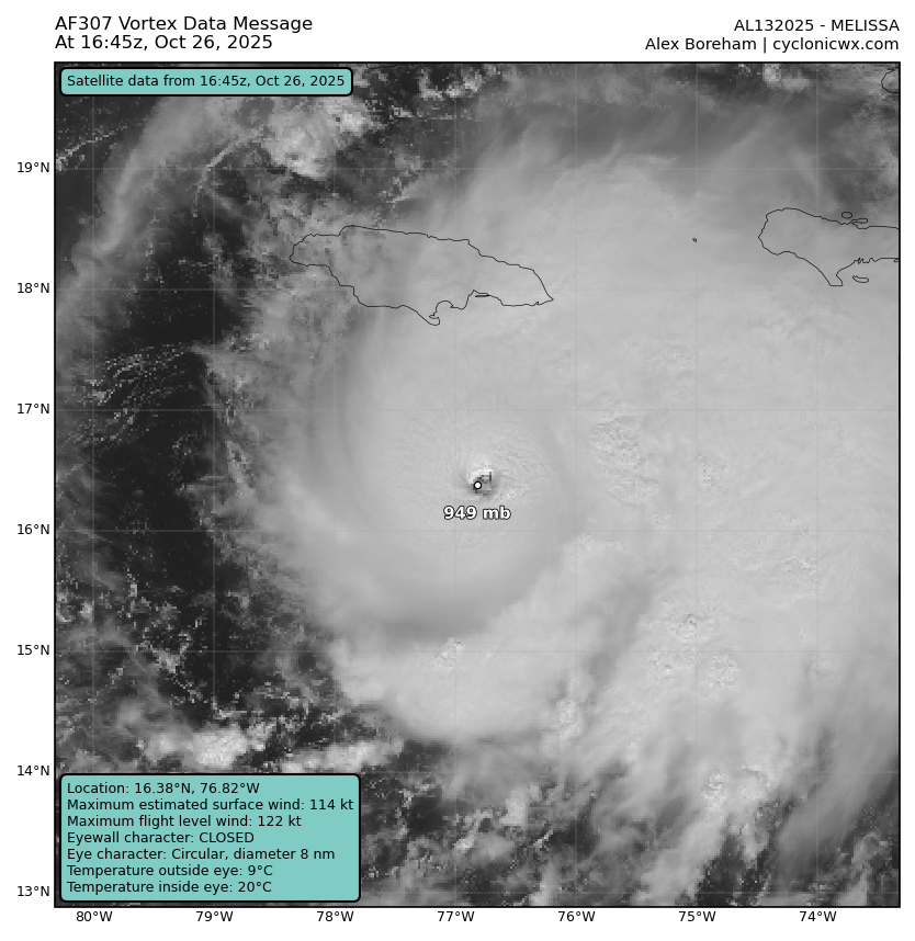
CrazyC83 wrote:Without Recon, this would probably be analyzed at 130-135 kt right now. The best guess on that data is 115 kt for the actual intensity.
It's almost an inverse of Delta 2020, which in the Caribbean never went above T5.0 but aircraft supported 120 kt.


chaser1 wrote:Just want to shout out a quick "THANKS" to fellow members for imparting some really insightful details and analysis regarding a few micro characteristics at hand that play into a major hurricane's subtle fluctuations, RI, and the often occuring "secondary" or appendage blob affect that seems to occur in an number of Atlantic basin storms. The combination of a great satellite and radar presentation along with well explained & concise explanation makes for a great sit-back with popcorn visual learning event
CrazyC83 wrote:Without Recon, this would probably be analyzed at 130-135 kt right now. The best guess on that data is 115 kt for the actual intensity.
It's almost an inverse of Delta 2020, which in the Caribbean never went above T5.0 but aircraft supported 120 kt.


USTropics wrote:It's difficult to ascertain exactly what is going on without some tail doppler radar. While fully closed, the western side of the eyewall hasn't exhibited the same level of depth as the eastern eyewall for much of past 6 hours (with even brief periods of being open). Here is the latest radar image:
https://i.imgur.com/PmrlUJW.png
TROPICS-5 pass from about 2 hours ago:
https://i.imgur.com/h355b8v.jpeg
https://i.imgur.com/ojlfvPv.png

BobHarlem wrote:WaveBreaking wrote:Is Jamaica's met website broken for anyone else too? I was trying to see radar but barely anything's loaded.
This mirror works well and doesnt have any gaps
https://flhurricane.com/imageanimator.php?960


Users browsing this forum: No registered users and 119 guests


