
NATL: MELISSA - Aftermath - Discussion
Moderator: S2k Moderators
-
Hypercane_Kyle

- Category 5

- Posts: 3465
- Joined: Sat Mar 07, 2015 7:58 pm
- Location: Cape Canaveral, FL
Re: NATL: MELISSA - Hurricane - Discussion
1 likes
My posts are my own personal opinion, defer to the National Hurricane Center (NHC) and other NOAA products for decision making during hurricane season.
Re: NATL: MELISSA - Hurricane - Discussion
I think it’s Miss piggy that is south of Cuba and heading towards Melissa. Hopefully it can get there at a good time.
1 likes

-
PavelGaborik10
- Category 1

- Posts: 472
- Joined: Tue Sep 04, 2018 3:23 pm
Re: NATL: MELISSA - Hurricane - Discussion
zzzh wrote:https://i.imgur.com/ihimXjF.png
I think the plane won't catch the peak
This storm is 40 hours away from landfall.
2 likes
-
Iceresistance

- Category 5
- Posts: 9608
- Age: 22
- Joined: Sat Oct 10, 2020 9:45 am
- Location: Tecumseh, OK/Norman, OK
Re: NATL: MELISSA - Hurricane - Discussion
zzzh wrote:https://i.imgur.com/ihimXjF.png
I think the plane won't catch the peak
I mean, a newer scan has this. The moat is much smaller
https://s12.gifyu.com/images/b3uA0.png
3 likes
Bill 2015 & Beta 2020
Winter 2020-2021
All observations are in Tecumseh, OK unless otherwise noted.
Winter posts are focused mainly for Oklahoma & Texas.
Take any of my forecasts with a grain of salt, refer to the NWS, SPC, and NHC for official information
Never say Never with weather! Because ANYTHING is possible!
Winter 2020-2021
All observations are in Tecumseh, OK unless otherwise noted.
Winter posts are focused mainly for Oklahoma & Texas.
Take any of my forecasts with a grain of salt, refer to the NWS, SPC, and NHC for official information
Never say Never with weather! Because ANYTHING is possible!

Re: NATL: MELISSA - Hurricane - Discussion
Iceresistance wrote:zzzh wrote:https://i.imgur.com/ihimXjF.png
I think the plane won't catch the peak
I mean, a newer scan has this. The moat is much smaller
https://s12.gifyu.com/images/b3uA0.png
https://s12.gifyu.com/images/b3uA0.png
I wonder if we may see an eyewall meld. HAFS runs have shown close concentric eyewalls similar to this that don’t trigger a full-blown EWRC.
Either way, recon should be close enough for us to extrapolate backwards if necessary.
2 likes
Irene '11 Sandy '12 Hermine '16 5/15/2018 Derecho Fay '20 Isaias '20 Elsa '21 Henri '21 Ida '21
I am only a meteorology enthusiast who knows a decent amount about tropical cyclones. Look to the professional mets, the NHC, or your local weather office for the best information.
I am only a meteorology enthusiast who knows a decent amount about tropical cyclones. Look to the professional mets, the NHC, or your local weather office for the best information.
-
ScottNAtlanta

- Category 5
- Posts: 2535
- Joined: Sat May 25, 2013 3:11 pm
- Location: Atlanta, GA
Re: NATL: MELISSA - Hurricane - Discussion
Live stream from Jamaica...while it lasts
https://www.youtube.com/watch?v=qvhfvU6SWqc
https://www.youtube.com/watch?v=qvhfvU6SWqc
0 likes
The posts in this forum are NOT official forecast and should not be used as such. They are just the opinion of the poster and may or may not be backed by sound meteorological data. They are NOT endorsed by any professional institution or storm2k.org. For official information, please refer to the NHC and NWS products.
-
Sciencerocks
- Category 5
- Posts: 10193
- Age: 40
- Joined: Thu Jul 06, 2017 1:51 am


Re: NATL: MELISSA - Hurricane - Discussion
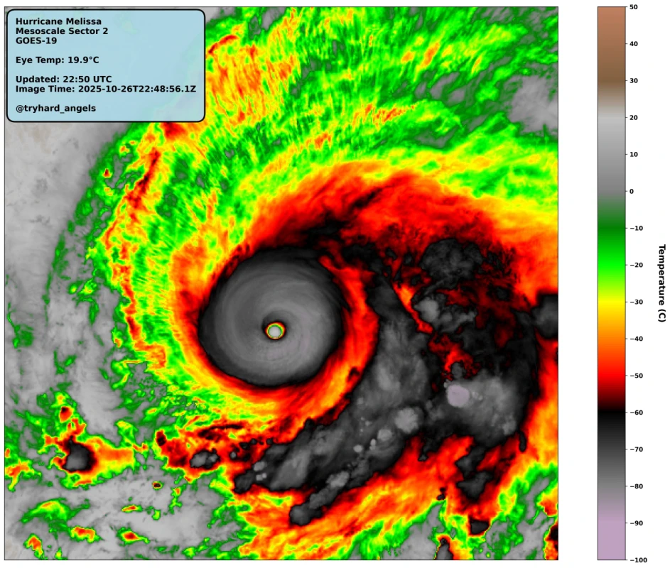
Melissa still looks almost as good as it has been in the past hour -- which is itself the best that it had ever looked all day, with the perfectly round CDO and almost a full CMG ring -- but the recent frames show slight degradation to the west. How much that's related to the mold discussed above is anyone's guess.

3 likes
TC naming lists: retirements and intensity
Most aggressive Advisory #1's in North Atlantic (cr. kevin for starting the list)
Most aggressive Advisory #1's in North Atlantic (cr. kevin for starting the list)
-
WaveBreaking

- Category 2

- Posts: 728
- Joined: Sun Jun 30, 2024 11:33 am
- Location: US
Re: NATL: MELISSA - Hurricane - Discussion
The CDO just started to rotate really quickly like it's vibrating. Hurricane Jova did the same thing when it was rapidly intensifying too.

7 likes
I am NOT a professional meteorologist, so take all of my posts with a grain of salt. My opinions are mine and mine alone.
-
ScottNAtlanta
- Category 5
- Posts: 2535
- Joined: Sat May 25, 2013 3:11 pm
- Location: Atlanta, GA
Re: NATL: MELISSA - Hurricane - Discussion
Recon is about 50 miles NW of Jamaica, so they might arrive to sample the peak
0 likes
The posts in this forum are NOT official forecast and should not be used as such. They are just the opinion of the poster and may or may not be backed by sound meteorological data. They are NOT endorsed by any professional institution or storm2k.org. For official information, please refer to the NHC and NWS products.
-
ScottNAtlanta
- Category 5
- Posts: 2535
- Joined: Sat May 25, 2013 3:11 pm
- Location: Atlanta, GA
Re: NATL: MELISSA - Hurricane - Discussion
WaveBreaking wrote:The CDO just started to rotate really quickly like it's vibrating. Hurricane Jova did the same thing when it was rapidly intensifying too.
https://i.imgur.com/FJGHaTM.gif
Its wild being able to see the eye actually contracting
5 likes
The posts in this forum are NOT official forecast and should not be used as such. They are just the opinion of the poster and may or may not be backed by sound meteorological data. They are NOT endorsed by any professional institution or storm2k.org. For official information, please refer to the NHC and NWS products.
-
cheezyWXguy

- Category 5
- Posts: 6282
- Joined: Mon Feb 13, 2006 12:29 am
- Location: Dallas, TX
Re: NATL: MELISSA - Hurricane - Discussion
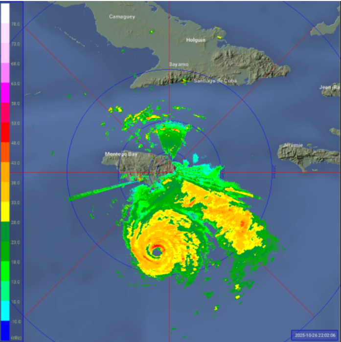
Those radar images suggest the outer eyewall is already very well formed and the moat is very narrow. Should be a smoother than average transition to the new eyewall, if not an outright meld, during the overnight hours. I wonder what intensity recon will find this at shortly.
7 likes
-
USTropics
- Professional-Met

- Posts: 2742
- Joined: Sun Aug 12, 2007 3:45 am
- Location: Florida State University
Re: NATL: MELISSA - Hurricane - Discussion
ScottNAtlanta wrote:Recon is about 50 miles NW of Jamaica, so they might arrive to sample the peak
I honestly think we're looking at a Milton scenario here, recon should get there to sample this peak. If our hurricane models are correct, we're looking at another peak in ~36 hours, HAFS-A and HAFS-B modeled the pressure to get down to 910mb. The only variable that can prevent Melissa from reaching MPI is literally an internal structure change like an EWRC. We'll have to wait and see when that occurs and how it needs to recover after, but definitely a catastrophic scenario that is going to unfold on Tuesday in Jamaica.
7 likes
Re: NATL: MELISSA - Hurricane - Discussion
Long range radar loop (the short range one hasn't been updated in a few hours)
5 likes
Re: NATL: MELISSA - Hurricane - Discussion
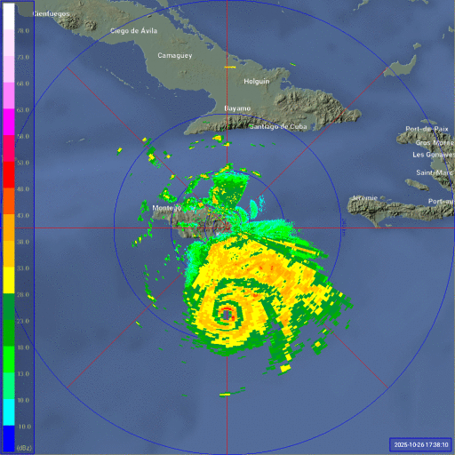
Looks like a perfectly circular donut... with still another day over the warmest waters of the Atlantic.
10 likes
-
cycloneye

- Admin

- Posts: 149751
- Age: 69
- Joined: Thu Oct 10, 2002 10:54 am
- Location: San Juan, Puerto Rico
Re: NATL: MELISSA - Hurricane - Discussion
USTropics wrote:ScottNAtlanta wrote:Recon is about 50 miles NW of Jamaica, so they might arrive to sample the peak
I honestly think we're looking at a Milton scenario here, recon should get there to sample this peak. If our hurricane models are correct, we're looking at another peak in ~36 hours, HAFS-A and HAFS-B modeled the pressure to get down to 910mb. The only variable that can prevent Melissa from reaching MPI is literally an internal structure change like an EWRC. We'll have to wait and see when that occurs and how it needs to recover after, but definitely a catastrophic scenario that is going to unfold on Tuesday in Jamaica.
Sadly no matter what about your last sentence.
5 likes
Visit the Caribbean-Central America Weather Thread where you can find at first post web cams,radars
and observations from Caribbean basin members Click Here
and observations from Caribbean basin members Click Here
-
USTropics
- Professional-Met
- Posts: 2742
- Joined: Sun Aug 12, 2007 3:45 am
- Location: Florida State University
Re: NATL: MELISSA - Hurricane - Discussion
The one thing I am seeing right now, and you have to get a really good high-res longwave IR product going, is a slight degradation in the western inner core. Temperatures have been going up in the last ~90 minutes here in this quadrant:

4 likes
-
eastcoastFL

- Category 5
- Posts: 3996
- Age: 44
- Joined: Thu Apr 12, 2007 12:29 pm
- Location: Palm City, FL
Re: NATL: MELISSA - Hurricane - Discussion
Melissa is looking more and more impressive on radar every minute. Amazing
2 likes
Personal Forecast Disclaimer:
The posts in this forum are NOT official forecast and should not be used as such. They are just the opinion of the poster and may or may not be backed by sound meteorological data. They are NOT endorsed by any professional institution or storm2k.org. For official information, please refer to the NHC and NWS products.
The posts in this forum are NOT official forecast and should not be used as such. They are just the opinion of the poster and may or may not be backed by sound meteorological data. They are NOT endorsed by any professional institution or storm2k.org. For official information, please refer to the NHC and NWS products.
-
Hypercane_Kyle
- Category 5
- Posts: 3465
- Joined: Sat Mar 07, 2015 7:58 pm
- Location: Cape Canaveral, FL
Re: NATL: MELISSA - Hurricane - Discussion
USTropics wrote:The one thing I am seeing right now, and you have to get a really good high-res longwave IR product going, is a slight degradation in the western inner core. Temperatures have been going up in the last ~90 minutes here in this quadrant:
https://i.imgur.com/G1swuUp.gif
You can see quite a tongue of dry air intruding outside of the CDO. No idea if it's mixing in though. Might just be enough to keep it from going sub-920mb or something crazy tonight.
0 likes
My posts are my own personal opinion, defer to the National Hurricane Center (NHC) and other NOAA products for decision making during hurricane season.
Who is online
Users browsing this forum: No registered users and 34 guests