NATL: MELISSA - Aftermath - Discussion
Moderator: S2k Moderators
-
ScottNAtlanta

- Category 5

- Posts: 2535
- Joined: Sat May 25, 2013 3:11 pm
- Location: Atlanta, GA
Re: NATL: MELISSA - Hurricane - Discussion
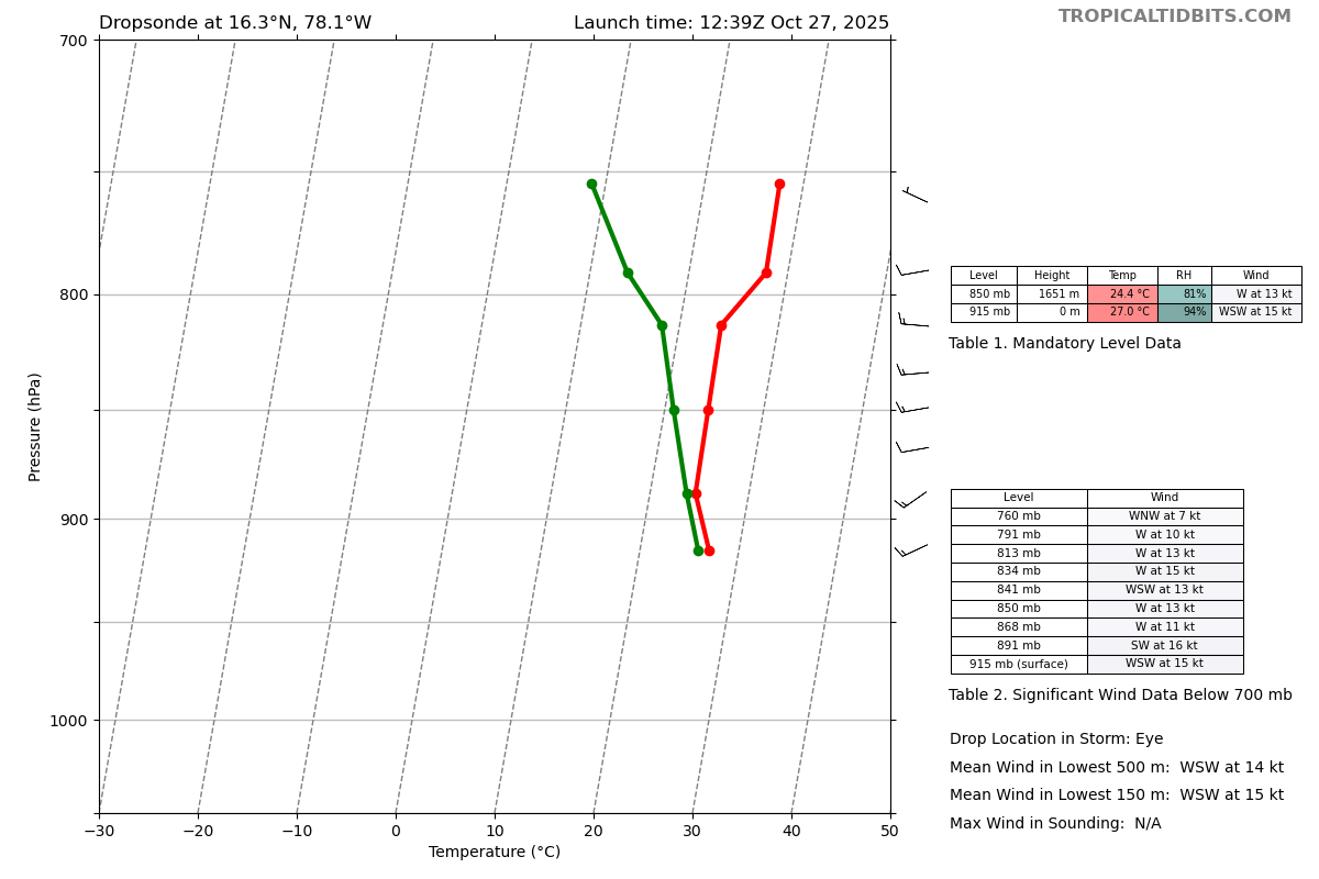
30 degrees C in the eye, that has to be close to a record (the latest reading from vortex msg)
Last edited by ScottNAtlanta on Mon Oct 27, 2025 8:15 am, edited 1 time in total.
4 likes
The posts in this forum are NOT official forecast and should not be used as such. They are just the opinion of the poster and may or may not be backed by sound meteorological data. They are NOT endorsed by any professional institution or storm2k.org. For official information, please refer to the NHC and NWS products.

Re: NATL: MELISSA - Hurricane - Discussion
I am not seeing any WNW component of track over the past several frames. Right now, due west and Melissa is presently passing the NHC recent 5:00 a.m. forecast point.
0 likes
Andy D
(For official information, please refer to the NHC and NWS products.)
(For official information, please refer to the NHC and NWS products.)
-
dukeblue219
- S2K Supporter

- Posts: 556
- Joined: Fri Sep 30, 2016 3:52 pm
Re: NATL: MELISSA - Hurricane - Discussion
It's not just the 194kt reading 12mb off the surface that's amazing - it's 170 and 180kt readings all the way down on that drop. Yikes.
5 likes

Re: NATL: MELISSA - Hurricane - Discussion
wow the surface reduction from the WL150 winds supports 145-150kts, I would lean towards 145kts given that its right on the edge between the two and the gust at the surface is only 151kts.
1 likes
-
Stormgodess

- Category 1

- Posts: 316
- Joined: Mon Sep 14, 2020 1:31 am
Re: NATL: MELISSA - Hurricane - Discussion
eastcoastFL wrote:Does anyone know where Josh is riding out the storm? Any other chasers decide to go to Jamaica?
Not chasers but United Cajun Navy has a crew staged in Kingston for search/rescue/recovery. Not sure how large a group though because they still have a large crew in Alaska
2 likes
-
ScottNAtlanta
- Category 5
- Posts: 2535
- Joined: Sat May 25, 2013 3:11 pm
- Location: Atlanta, GA
Re: NATL: MELISSA - Hurricane - Discussion
ScottNAtlanta wrote:30 degrees C in the eye, that has to be close to a record (the latest reading from vortex msg)
Patricia had 32.2, and Typhoon Judy (current warmest on record) had a temp of 34...so not too far off
Last edited by ScottNAtlanta on Mon Oct 27, 2025 8:23 am, edited 1 time in total.
0 likes
The posts in this forum are NOT official forecast and should not be used as such. They are just the opinion of the poster and may or may not be backed by sound meteorological data. They are NOT endorsed by any professional institution or storm2k.org. For official information, please refer to the NHC and NWS products.

Re: NATL: MELISSA - Hurricane - Discussion
NOAA's eye drop is 915 mb with 15 kt winds, strangely similar to the earlier passes an hour ago, and higher than extrap on both planes from this pass.
No signs of eye drying out yet.
No signs of eye drying out yet.
1 likes
TC naming lists: retirements and intensity
Most aggressive Advisory #1's in North Atlantic (cr. kevin for starting the list)
Most aggressive Advisory #1's in North Atlantic (cr. kevin for starting the list)
-
Keldeo1997
- Category 2

- Posts: 688
- Joined: Fri Oct 11, 2019 11:35 pm

-
ScottNAtlanta
- Category 5
- Posts: 2535
- Joined: Sat May 25, 2013 3:11 pm
- Location: Atlanta, GA
Re: NATL: MELISSA - Hurricane - Discussion
I just looked, and there are 202 guests on this thread...wow
1 likes
The posts in this forum are NOT official forecast and should not be used as such. They are just the opinion of the poster and may or may not be backed by sound meteorological data. They are NOT endorsed by any professional institution or storm2k.org. For official information, please refer to the NHC and NWS products.
Re: NATL: MELISSA - Hurricane - Discussion
Stormgodess wrote:eastcoastFL wrote:Does anyone know where Josh is riding out the storm? Any other chasers decide to go to Jamaica?
Not chasers but United Cajun Navy has a crew staged in Kingston for search/rescue/recovery. Not sure how large a group though because they still have a large crew in Alaska
Thats mindblowing.... and really cool too
I had no clue they as an organization were that large or that organized.
0 likes
Andy D
(For official information, please refer to the NHC and NWS products.)
(For official information, please refer to the NHC and NWS products.)
Re: NATL: MELISSA - Hurricane - Discussion
zzzh wrote:
extrap pressure
The AF plane never measured any sub-910 extrap pressure, though. Even the NOAA didn't go that low (and I wouldn't expect an AF VDM to use NOAA data).
The original VDM message only said 916 mb, and AF's dropsonade data hasn't been available yet. So I have no idea where the 907 could have plausibly come from.
Last edited by Teban54 on Mon Oct 27, 2025 8:32 am, edited 1 time in total.
2 likes

-
Blown Away

- S2K Supporter
- Posts: 10253
- Joined: Wed May 26, 2004 6:17 am
Re: NATL: MELISSA - Hurricane - Discussion
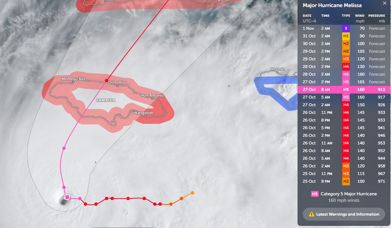
Melissa definitely WSW of the track.
Last edited by Blown Away on Mon Oct 27, 2025 8:33 am, edited 1 time in total.
0 likes
Hurricane Eye Experience: David 79, Irene 99, Frances 04, Jeanne 04, Wilma 05… Hurricane Brush Experience: Andrew 92, Erin 95, Floyd 99, Matthew 16, Irma 17, Ian 22, Nicole 22…
Re: NATL: MELISSA - Hurricane - Discussion
Blown Away wrote:[url]https://i.postimg.cc/sgPtRP8N/Melissa.jpg [/url]
Melissa is supposed to be going N at 78.1W and continues moving WNW. This should move the landfall point farther W on Jamaica.
11pm forecast had it getting to 78.2W. I wish the forecast points were at 6 hour intervals instead of 12 to align better with advisories -- it always gets folks thinking there's a track shift, when there actually wasn't (as is the case here). But it's not really off unless it gets beyond 78.2W.
Last edited by BobHarlem on Mon Oct 27, 2025 8:35 am, edited 1 time in total.
1 likes
Re: NATL: MELISSA - Hurricane - Discussion
Seeing the feeder band creating a number of hot towers as it impinges on the main circulation.
Wonder if this will create a new eyewall.
Wonder if this will create a new eyewall.
0 likes
-
Stormgodess
- Category 1
- Posts: 316
- Joined: Mon Sep 14, 2020 1:31 am
Re: NATL: MELISSA - Hurricane - Discussion
chaser1 wrote:Stormgodess wrote:eastcoastFL wrote:Does anyone know where Josh is riding out the storm? Any other chasers decide to go to Jamaica?
Not chasers but United Cajun Navy has a crew staged in Kingston for search/rescue/recovery. Not sure how large a group though because they still have a large crew in Alaska
Thats mindblowing.... and really cool too.
I had no clue they as an organization were that large or that organized.
The guys that organized around the Aug 2016 Floods then went on to work Harvey in TX. Seemed to have really gotten their stuff together. They spent months and months in North Carolina too.
1 likes
Re: NATL: MELISSA - Hurricane - Discussion
ScottNAtlanta wrote:I just looked, and there are 202 guests on this thread...wow
Perhaps Bing [BOT] & Google [BOT] brought all their [BOT] friends
2 likes
Andy D
(For official information, please refer to the NHC and NWS products.)
(For official information, please refer to the NHC and NWS products.)
Re: NATL: MELISSA - Hurricane - Discussion
Stormgodess wrote:chaser1 wrote:Stormgodess wrote:
Not chasers but United Cajun Navy has a crew staged in Kingston for search/rescue/recovery. Not sure how large a group though because they still have a large crew in Alaska
Thats mindblowing.... and really cool too
I had no clue they as an organization were that large or that organized.
The guys that organized around the Aug 2016 Floods then went on to work Harvey in TX. Seemed to have really gotten their stuff together. They spent months and months in North Carolina too.
Beyond Josh, Jeff Piotrowski is there that I know of. Bryce Shelton and Paige Berdomas. Josh is Mandeville at the Golf View Hotel, but only as a home base he'll wind up wherever the eye goes (Probably close to Treasure Beach) This is an incredibly dangerous one for outsiders to go to because of the mountains, so I suspect this one may wind up with folks stuck for extended periods of time.
Last edited by BobHarlem on Mon Oct 27, 2025 8:41 am, edited 3 times in total.
2 likes
-
Blown Away
- S2K Supporter
- Posts: 10253
- Joined: Wed May 26, 2004 6:17 am
Re: NATL: MELISSA - Hurricane - Discussion
BobHarlem wrote:Blown Away wrote:[url]https://i.postimg.cc/sgPtRP8N/Melissa.jpg [/url]
Melissa is supposed to be going N at 78.1W and continues moving WNW. This should move the landfall point farther W on Jamaica.
11pm forecast had it getting to 78.2W. I wish the forecast points were at 6 hour intervals to align better with advisories. But it's not really off unless it gets beyond 78.2W.
5am had N turn at 78.1W, not a big difference, but that core is not huge, so 10-20 miles here or there will make a difference at landfall for someone.
1 likes
Hurricane Eye Experience: David 79, Irene 99, Frances 04, Jeanne 04, Wilma 05… Hurricane Brush Experience: Andrew 92, Erin 95, Floyd 99, Matthew 16, Irma 17, Ian 22, Nicole 22…
Who is online
Users browsing this forum: No registered users and 116 guests