
Melissa continues moving W of the NHC track...
Moderator: S2k Moderators


 Hurricanes: Andrew 1992 - Irene 1999 - Frances 2004 - Jeanne 2004 - Katrina 2005 - Wilma 2005 - Matthew 2016 - Irma 2017 - Ian 2022 - Nicole 2022 - Milton 2024

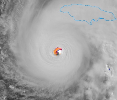
WaveBreaking wrote:One of the most violent CDOs I’ve ever seen, even more so than Jova’s.
https://i.imgur.com/rT4cxPC.gif
WaveBreaking wrote:One of the most violent CDOs I’ve ever seen, even more so than Jova’s.
https://i.imgur.com/rT4cxPC.gif


USTropics wrote:There are a lot of questions on how deep can Melissa get, or in other words what is the theoretical minimum pressure that this system can achieve. The answer is called maximum potential intensity (MPI). This is quite literally the most dangerous part of the Atlantic ocean in terms of MPI due to the sea surface temperatures (and the depth it goes to). Melissa could park over this region for days, and it would not upwell cooler waters:
https://i.imgur.com/iU4gpjr.gif
If you want to know the exact details (it's a bit of a read), but here is a post I made a while ago that outlines the mechanics of a hurricane and how to calculate MPI.
Determining the maximum wind speed a tropical cyclone can reach involves applying some thermodynamics, namely we model the mechanisms of a tropical cyclone as a Carnot heat engine (not too dissimilar from a motor/car engine). This allows us to determine the MPI (maximum potential intensity) as others have mentioned by using the Carnot cycle. But what exactly is a Carnot cycle and how does this physically look?
The Carnot cycle is characterized by four stages of expansion and compression. I created a crude diagram below to better show these stages in a cross-section of a mature hurricane:
The first stage (A→B) is isothermal expansion. In this stage, air flows inward towards the low pressure center for the storm.
The second stage (B→C) is adiabatic expansion. Air begins to rise adiabatically up the eyewall to the top of the atmosphere (TOA).
The third stage (C→D) is isothermal compression. Air now flows outward at this point and radiative cooling begins.
The fourth stage (D→A) is adiabatic compression, as air now sinks and begins to warm. Pressure increases, and the cycle begins again.
https://i.imgur.com/1UYbPBt.jpeg
Now that we can identify the inner mechanisms of a hurricane, what are we really trying to show here? First, we now know the ocean-hurricane interaction provides the fuel pump, and as a hurricane intensifies, a feedback loop begins. As wind speeds begin to increase, this also increases the evaporation rate, which in turn increases the latent heat supply that drives our Carnot engine.
Secondly, we can now apply some math equations to quantify what this value is. From our previous statement, we know our main source of latent heat/warm reservoir is our sea surface temperatures (i.e., through the evaporation process, latent heat is released). If we also treat our TOA as the outflow (think cool reservoir), we can now mathematically model a hurricane using the Carnot efficiency ratio. Skipping some of the setup using the First Law of Thermodynamics and determining work done for each leg of the cycle, we arrive at our most simplified equation:
https://i.imgur.com/ZwQOzhG.png
Where Ts is our inflow surface temperature of the ocean (hot reservoir), To is our TOA outflow temperature (cold reservoir), and E is a ratio of enthalpy and surface drag (i.e., heat exchange coefficients). In this sense, we can state the mechanical energy produced by our heat engine (V, or work done) is the energy of the winds (hurricane intensity)!
If we consider E to be constant (not the safest assumption, but will do for now), our maximum potential intensity, as stated by thermodynamics, is simply governed by the outflow temperature and the inflow temperature. In other words, this means changes in our cloud top convection or sea surface temperature strictly dictates the maximum wind speeds a tropical cyclone can reach.
With all that said, it’s important to note that we’re discussing the theoretical maximum potential intensity. Cyclones rarely reach this intensity because this requires ideal atmosphere and oceanic conditions—in other words, environmental factors rarely allow a system to reach MPI. This includes
Land interaction: this obviously removes our fuel source (latent heat release from the ocean surface)
Vertical wind shear: This causes the cyclones core to become asymmetrical, weakening the convective pattern or even creating an absence of convection on the upshear side of the cyclone (this raises our To)
Ocean interaction: As stated previously, increased wind speed can increase evaporation, but too much wind speed over a very specific area of the ocean can also cause upwelling. This localized cooling of the ocean layer decreases our Ts variable.
Dry air entrainment: If our adiabatic cooling/expansion leg of the cycle becomes disrupted by dry air, this decreases the convective potential of our cyclone and To.
Woofde wrote:If 12z HAFS are to be believed this is likely peaking right now, the meld slows it down a touch afterwards. Very easily could be <900mb, 165kts and we will have no recon to catch it until after its peaks. The current IR presentation does make the theory believable.aspen wrote:Teban54 wrote:The IR (especially its last few frames) do almost look like an EWRC, although that can sometimes be deceiving.
https://i.imgur.com/4HGlter.gif
I think it’s probably another meld. Radar does still show some concentric outer bands, and the 12z HAFS models predict a meld/very brief EWRC before it unfortunately strengthens again into landfall.
michelinj wrote:I do think some eyewall replacement cycle is starting or occurring. The last few frames on imagery just show the CDO not as smooth as before. It would also fit in with the last eye drop just being a fraction drier. Whether it's another merger or a full cycle I'm not sure. Recon a while ago didn't show any double wind maxima so if so then it's come on rather quickly. Radar doesn't have much of a moat either so perhaps more merger than replacement.
If an EWRC of sorts is happening then could be a crucial few hours for Jamaica. Have seen it before where a little dry air or shear at just the wrong time when a storm is vulnerable mid-EWRC and it can really weaken a system. On the other hand a successful cycle and the wind field will expand, bringing some pretty populated areas within reach of stronger winds, and with ample time to strengthen further.
So not saying an EWRC is definitely happening, but certainly a change of some kind on IR imagery atm.


Iceresistance wrote:Around 10-15 minutes ago, but look at the amount of eyewall lightning on the northwestern side
https://s12.gifyu.com/images/b3cTh.png
https://s12.gifyu.com/images/b3cTh.png
Hurricane2022 wrote:Iceresistance wrote:Around 10-15 minutes ago, but look at the amount of eyewall lightning on the northwestern side
https://s12.gifyu.com/images/b3cTh.png
https://s12.gifyu.com/images/b3cTh.png
The CDO is also cooling and the eye apparently shrunk a bit in the last frames. Recon is about to depart!
Users browsing this forum: No registered users and 48 guests


