NATL: MELISSA - Aftermath - Discussion
Moderator: S2k Moderators
-
Hurricane Mike
- Category 2

- Posts: 675
- Joined: Tue Apr 10, 2018 7:44 am
Re: NATL: MELISSA - Hurricane - Discussion
Melissa looks like it strengthened a bit the last few hours. Incredible.
2 likes
-
AxaltaRacing24
- Category 5

- Posts: 1774
- Age: 25
- Joined: Wed Jul 27, 2016 11:14 am
- Location: Jupiter, FL
-
Category5Kaiju

- Category 5
- Posts: 4345
- Joined: Thu Dec 24, 2020 12:45 pm
- Location: Seattle during the summer, Phoenix during the winter
Re: NATL: MELISSA - Hurricane - Discussion
Literally looks like something out of the WPAC, yikes
2 likes
Unless explicitly stated, all information in my posts is based on my own opinions and observations. Tropical storms and hurricanes can be extremely dangerous. Refer to an accredited weather research agency or meteorologist if you need to make serious decisions regarding an approaching storm.
-
TeamPlayersBlue

- Category 5
- Posts: 3531
- Joined: Tue Feb 02, 2010 1:44 am
- Location: Denver/Applewood, CO
Re: NATL: MELISSA - Hurricane - Discussion
IsabelaWeather wrote:galaxy401 wrote:tolakram wrote:It hit the ridge, wobbled a bit, now stationary to just a bit of eastward motion IMO.
I wonder if the NNE motion is now starting with Melissa. She is a real monster tonight. Only good news is that if she continues to drift, she'll soon start upwelling cooler water. That's how Dorian started to weaken.
There wont be any upwelling that matters, 80* goes down to like 600m or something here.
Would need to stay in the same place for almost 24 hours for this to happen.
0 likes
Personal Forecast Disclaimer:
The posts in this forum are NOT official forecast and should not be used as such. They are just the opinion of the poster and may or may not be backed by sound meteorological data. They are NOT endorsed by any professional institution or storm2k.org. For official information, please refer to the NHC and NWS products.
The posts in this forum are NOT official forecast and should not be used as such. They are just the opinion of the poster and may or may not be backed by sound meteorological data. They are NOT endorsed by any professional institution or storm2k.org. For official information, please refer to the NHC and NWS products.

Re: NATL: MELISSA - Hurricane - Discussion
The new record ADT Final T#/CI# is 8.2, at least for this half hour. The satellite presence of Melissa is almost unbelievable, even if it isn't reflected at the surface.
4 likes
-
Hypercane_Kyle

- Category 5
- Posts: 3465
- Joined: Sat Mar 07, 2015 7:58 pm
- Location: Cape Canaveral, FL
Re: NATL: MELISSA - Hurricane - Discussion
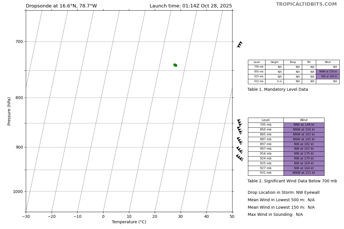
Iceresistance wrote:I think Melissa killed this dropsonde
https://s12.gifyu.com/images/b3c0V.png
https://s12.gifyu.com/images/b3c0V.png
Yeah... not much going to survive 175 knots.
0 likes
My posts are my own personal opinion, defer to the National Hurricane Center (NHC) and other NOAA products for decision making during hurricane season.

Re: NATL: MELISSA - Hurricane - Discussion
Looks like the NOAA plane is heading home. Leaves the AF plane left in there, worth noting that was the one with the 902.8 reading before and dropsonde showed 906 so worth remembering for future passes
2 likes

Re: NATL: MELISSA - Hurricane - Discussion
Just a jaw dropping satellite presentation. It’s hard to get a storm in the Atlantic… or any basin for that matter… that looks this textbook-perfect.
2 likes

Re: NATL: MELISSA - Hurricane - Discussion
Wobbling due east now.
0 likes
Igor 2010, Sandy 2012, Fay 2014, Gonzalo 2014, Joaquin 2015, Nicole 2016, Humberto 2019, Imelda 2025
I am only a tropical weather enthusiast. My predictions are not official and may or may not be backed by sound meteorological data. For official information, please refer to the NHC and NWS products.
I am only a tropical weather enthusiast. My predictions are not official and may or may not be backed by sound meteorological data. For official information, please refer to the NHC and NWS products.
-
eastcoastFL

- Category 5
- Posts: 3996
- Age: 44
- Joined: Thu Apr 12, 2007 12:29 pm
- Location: Palm City, FL
Re: NATL: MELISSA - Hurricane - Discussion
AxaltaRacing24 wrote:This is by far the best Melissa has looked.
And that's saying a lot because she's looked incredible for days now.
1 likes
Personal Forecast Disclaimer:
The posts in this forum are NOT official forecast and should not be used as such. They are just the opinion of the poster and may or may not be backed by sound meteorological data. They are NOT endorsed by any professional institution or storm2k.org. For official information, please refer to the NHC and NWS products.
The posts in this forum are NOT official forecast and should not be used as such. They are just the opinion of the poster and may or may not be backed by sound meteorological data. They are NOT endorsed by any professional institution or storm2k.org. For official information, please refer to the NHC and NWS products.
-
eastcoastFL
- Category 5
- Posts: 3996
- Age: 44
- Joined: Thu Apr 12, 2007 12:29 pm
- Location: Palm City, FL
Re: NATL: MELISSA - Hurricane - Discussion
Kazmit wrote:Wobbling due east now.
She's starting to feel the trough now. Should start seeing movement towards the north pretty soon
0 likes
Personal Forecast Disclaimer:
The posts in this forum are NOT official forecast and should not be used as such. They are just the opinion of the poster and may or may not be backed by sound meteorological data. They are NOT endorsed by any professional institution or storm2k.org. For official information, please refer to the NHC and NWS products.
The posts in this forum are NOT official forecast and should not be used as such. They are just the opinion of the poster and may or may not be backed by sound meteorological data. They are NOT endorsed by any professional institution or storm2k.org. For official information, please refer to the NHC and NWS products.
Re: NATL: MELISSA - Hurricane - Discussion

9 likes
Igor 2010, Sandy 2012, Fay 2014, Gonzalo 2014, Joaquin 2015, Nicole 2016, Humberto 2019, Imelda 2025
I am only a tropical weather enthusiast. My predictions are not official and may or may not be backed by sound meteorological data. For official information, please refer to the NHC and NWS products.
I am only a tropical weather enthusiast. My predictions are not official and may or may not be backed by sound meteorological data. For official information, please refer to the NHC and NWS products.
-
eastcoastFL
- Category 5
- Posts: 3996
- Age: 44
- Joined: Thu Apr 12, 2007 12:29 pm
- Location: Palm City, FL
Re: NATL: MELISSA - Hurricane - Discussion
That pink donut is inching closer to Jamaica now.
2 likes
Personal Forecast Disclaimer:
The posts in this forum are NOT official forecast and should not be used as such. They are just the opinion of the poster and may or may not be backed by sound meteorological data. They are NOT endorsed by any professional institution or storm2k.org. For official information, please refer to the NHC and NWS products.
The posts in this forum are NOT official forecast and should not be used as such. They are just the opinion of the poster and may or may not be backed by sound meteorological data. They are NOT endorsed by any professional institution or storm2k.org. For official information, please refer to the NHC and NWS products.

-
Hypercane_Kyle
- Category 5
- Posts: 3465
- Joined: Sat Mar 07, 2015 7:58 pm
- Location: Cape Canaveral, FL
Re: NATL: MELISSA - Hurricane - Discussion
Looking at the last few frames, I do genuinely believe the N-NNE turn has begun towards Jamaica. No doubt this is looking the best it has its entire life.

10 likes
My posts are my own personal opinion, defer to the National Hurricane Center (NHC) and other NOAA products for decision making during hurricane season.
-
Hurricane2022

- Category 5
- Posts: 2092
- Joined: Tue Aug 23, 2022 11:38 pm
- Location: Araçatuba, Brazil
Re: NATL: MELISSA - Hurricane - Discussion
I will pray hard for the Jamaicans tomorrow at church ...May God help them.
https://x.com/HurricaneJasonX/status/1982988843390320934
https://x.com/HurricaneJasonX/status/1982988843390320934
Last edited by Hurricane2022 on Mon Oct 27, 2025 9:11 pm, edited 1 time in total.
2 likes
Sorry for the bad English sometimes...!
For reliable and detailed information for any meteorological phenomenon, please consult the National Hurricane Center, Joint Typhoon Warning Center , or your local Meteo Center.
--------
ECCE OMNIA NOVA FACIAM (Ap 21,5).
For reliable and detailed information for any meteorological phenomenon, please consult the National Hurricane Center, Joint Typhoon Warning Center , or your local Meteo Center.
--------
ECCE OMNIA NOVA FACIAM (Ap 21,5).
-
eastcoastFL
- Category 5
- Posts: 3996
- Age: 44
- Joined: Thu Apr 12, 2007 12:29 pm
- Location: Palm City, FL
Re: NATL: MELISSA - Hurricane - Discussion
Hypercane_Kyle wrote:Looking at the last few frames, I do genuinely believe the N-NNE turn has begun towards Jamaica. No doubt this is looking the best it has its entire life.
https://i.imgur.com/tjnX91x.png
This about when some of the hurricane models had Melissa making another intensity run before peaking.
3 likes
Personal Forecast Disclaimer:
The posts in this forum are NOT official forecast and should not be used as such. They are just the opinion of the poster and may or may not be backed by sound meteorological data. They are NOT endorsed by any professional institution or storm2k.org. For official information, please refer to the NHC and NWS products.
The posts in this forum are NOT official forecast and should not be used as such. They are just the opinion of the poster and may or may not be backed by sound meteorological data. They are NOT endorsed by any professional institution or storm2k.org. For official information, please refer to the NHC and NWS products.
-
Tireman4

- S2K Supporter

- Posts: 5904
- Age: 60
- Joined: Fri Jun 30, 2006 1:08 pm
- Location: Humble, Texas
- Contact:
Re: NATL: MELISSA - Hurricane - Discussion
I know this is an understatement, but this is bad. This is really bad. Sigh
11 likes
-
Hurricane2022
- Category 5
- Posts: 2092
- Joined: Tue Aug 23, 2022 11:38 pm
- Location: Araçatuba, Brazil
Re: NATL: MELISSA - Hurricane - Discussion
Hurricane2022 wrote:I will pray a rosary for the Jamaicans tomorrow...May God help them.
https://x.com/HurricaneJasonX/status/1982988843390320934
Melissa's excessively slow movement scares me considerably, not to mention that I am thousands of kilometers away from this thing. It's like a monster slowly walking towards our bedroom at midnight, like a scene from a horror movie or perhaps even a childhood fear.
6 likes
Sorry for the bad English sometimes...!
For reliable and detailed information for any meteorological phenomenon, please consult the National Hurricane Center, Joint Typhoon Warning Center , or your local Meteo Center.
--------
ECCE OMNIA NOVA FACIAM (Ap 21,5).
For reliable and detailed information for any meteorological phenomenon, please consult the National Hurricane Center, Joint Typhoon Warning Center , or your local Meteo Center.
--------
ECCE OMNIA NOVA FACIAM (Ap 21,5).
Re: NATL: MELISSA - Hurricane - Discussion
Am I gonna have to set an alarm for 3am? I really wanna see this thing's peak but I have work in the morning.
4 likes
Igor 2010, Sandy 2012, Fay 2014, Gonzalo 2014, Joaquin 2015, Nicole 2016, Humberto 2019, Imelda 2025
I am only a tropical weather enthusiast. My predictions are not official and may or may not be backed by sound meteorological data. For official information, please refer to the NHC and NWS products.
I am only a tropical weather enthusiast. My predictions are not official and may or may not be backed by sound meteorological data. For official information, please refer to the NHC and NWS products.
Who is online
Users browsing this forum: No registered users and 90 guests