NATL: MELISSA - Aftermath - Discussion: Josh Morgerman video of Melissa is up

Moderator: S2k Moderators

Message
Author
User avatar
Teban54
Category 5
Category 5
Posts: 3787
Joined: Sat May 19, 2018 1:19 pm

Re: NATL: MELISSA - Hurricane - Discussion

#2001 Postby Teban54 » Mon Oct 27, 2025 10:21 pm

Nuno wrote:
CrazyC83 wrote:
wx98 wrote:
Weird that despite the “I” curse, there’s no I storms here and 3 M storms.


Strongest of the "I" storms was Ivan at 910 mb, followed by Irma at 914 mb.


Crazy that Irma wasn't lower in her lifespan. Was she just too large?

Higher background pressure in the open Atlantic, especially at an earlier time of the year, would be my guess.
4 likes   

User avatar
Teban54
Category 5
Category 5
Posts: 3787
Joined: Sat May 19, 2018 1:19 pm

Re: NATL: MELISSA - Hurricane - Discussion

#2002 Postby Teban54 » Mon Oct 27, 2025 10:21 pm

CrazyC83 wrote:One thing that is scary: these -90C cloud top outer bands are hitting Jamaica and likely producing massive flooding and mudslides in the mountains...and will continue to do so...

And when they stop doing so, it wouldn't be long before they're replaced with -90C CDO instead, or if you're lucky, a 150 kt eye.
2 likes   

User avatar
Hurricane2022
Category 5
Category 5
Posts: 1957
Joined: Tue Aug 23, 2022 11:38 pm
Location: Araçatuba, Brazil

Re: NATL: MELISSA - Hurricane - Discussion

#2003 Postby Hurricane2022 » Mon Oct 27, 2025 10:22 pm

Did I hear someone saying "next pass"?? :roflmao:
Image
1 likes   
Sorry for the bad English sometimes...!
For reliable and detailed information for any meteorological phenomenon, please consult the National Hurricane Center, Joint Typhoon Warning Center , or your local Meteo Center.

--------

ECCE OMNIA NOVA FACIAM (Ap 21,5).

USTropics
Professional-Met
Professional-Met
Posts: 2732
Joined: Sun Aug 12, 2007 3:45 am
Location: Florida State University

Re: NATL: MELISSA - Hurricane - Discussion

#2004 Postby USTropics » Mon Oct 27, 2025 10:22 pm

REDHurricane wrote:Hurricane models have Melissa strengthening up until landfall -- if that holds true we maaaaaybe could get in the ballpark of Wilma. Maybe.


That's truly the scary part, the satellite presentation and environment are quite literally pristine. The only thing holding Melissa back from reaching MPI is herself basically (e.g., inner core changes, like EWRC). Theoretically, Melissa could push ~875mb if the stars aligned:

Image
8 likes   

User avatar
cheezyWXguy
Category 5
Category 5
Posts: 6242
Joined: Mon Feb 13, 2006 12:29 am
Location: Dallas, TX

Re: NATL: MELISSA - Hurricane - Discussion

#2005 Postby cheezyWXguy » Mon Oct 27, 2025 10:22 pm

REDHurricane wrote:Hurricane models have Melissa strengthening up until landfall -- if that holds true we maaaaaybe could get in the ballpark of Wilma. Maybe.

Shaving off another 20mb could be a stretch, though I suppose it’s not impossible. Rivaling Allen’s wind speed record is also a tall order but seems more achievable to me if it can mix those winds aloft down a bit more efficiently.
0 likes   

CrazyC83
Professional-Met
Professional-Met
Posts: 34308
Joined: Tue Mar 07, 2006 11:57 pm
Location: Deep South, for the first time!

Re: NATL: MELISSA - Hurricane - Discussion

#2006 Postby CrazyC83 » Mon Oct 27, 2025 10:23 pm

Hurricane2022 wrote:Did I hear someone saying "next pass"?? :roflmao:
https://i.imgur.com/XEM9g60.png


It has to move around Jamaica. It won't fly over it due to the mountains unless at cruising altitude.
1 likes   

wx98
Category 5
Category 5
Posts: 1396
Joined: Sat Aug 25, 2018 9:24 pm

Re: NATL: MELISSA - Hurricane - Discussion

#2007 Postby wx98 » Mon Oct 27, 2025 10:23 pm

Nuno wrote:
CrazyC83 wrote:
wx98 wrote:
Weird that despite the “I” curse, there’s no I storms here and 3 M storms.


Strongest of the "I" storms was Ivan at 910 mb, followed by Irma at 914 mb.


Crazy that Irma wasn't lower in her lifespan. Was she just too large?


Probably higher background pressure in the Atlantic making it harder to get lower (but low relative to the surrounding environment).
1 likes   

User avatar
mrbagyo
Category 5
Category 5
Posts: 3962
Age: 33
Joined: Thu Apr 12, 2012 9:18 am
Location: 14.13N 120.98E
Contact:

Re: NATL: MELISSA - Hurricane - Discussion

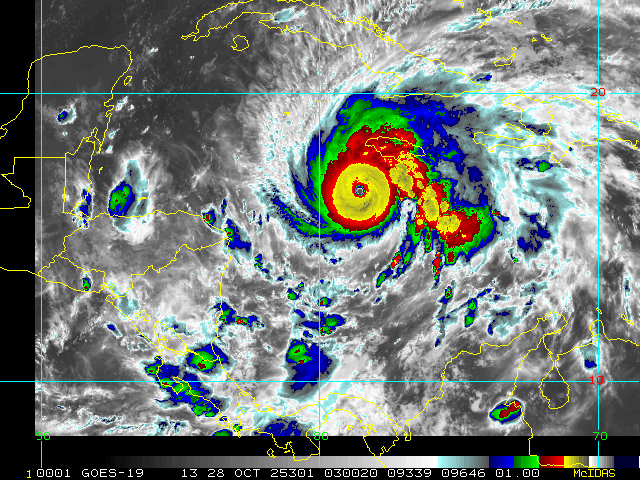
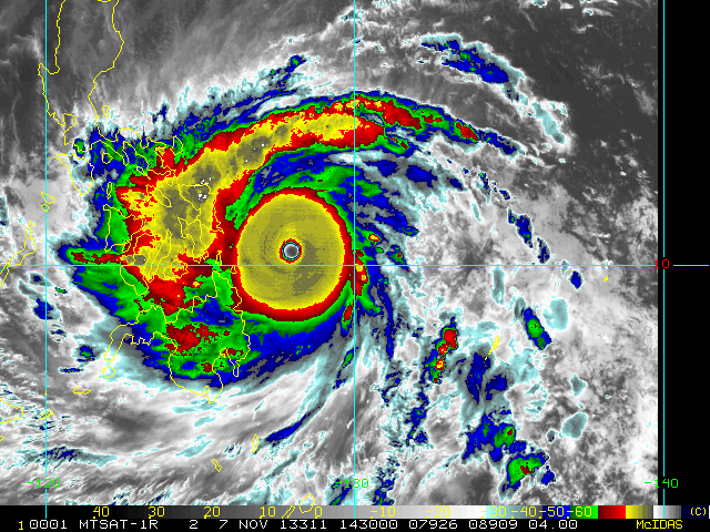
#2008 Postby mrbagyo » Mon Oct 27, 2025 10:25 pm

Image
Image

As good as it gets but ill still give the crown to Haiyan in terms of savage appearance (its pretty close)
11 likes   
The posts in this forum are NOT official forecast and should not be used as such. They are just the opinion of the poster and may or may not be backed by sound meteorological data. They are NOT endorsed by any professional institution or storm2k.org. For official information, please refer to RSMC, NHC and NWS products.

dukeblue219
S2K Supporter
S2K Supporter
Posts: 556
Joined: Fri Sep 30, 2016 3:52 pm

Re: NATL: MELISSA - Hurricane - Discussion

#2009 Postby dukeblue219 » Mon Oct 27, 2025 10:25 pm

Hurricane2022 wrote:Did I hear someone saying "next pass"?? :roflmao:
https://i.imgur.com/XEM9g60.png


The plane didn't turn around, if that's what you're suggesting. There's something weird in the very last data point so the plane looked stationary to the plotting app, which must have defaulted to pointing Eastward.
3 likes   

drewschmaltz
S2K Supporter
S2K Supporter
Posts: 351
Joined: Thu Aug 27, 2015 8:19 pm

Re: NATL: MELISSA - Hurricane - Discussion

#2010 Postby drewschmaltz » Mon Oct 27, 2025 10:26 pm

I just learned a bit about mountain "prominence" while hiking mt rainer. Though it's not the tallest in the lower 48, it has by far the most prominence. Is such a record kept for hurricanes? Their mb differential?
1 likes   
I HAVE ABSOLUTELY NO IDEA WHAT I'M TALKING ABOUT. PLEASE CONSULT SOMEONE WHO DOES. START WITH THE NHC. ALL POSTS ARE FOR ENTERTAINMENT PURPOSES ONLY.

User avatar
ElectricStorm
Category 5
Category 5
Posts: 5121
Age: 24
Joined: Tue Aug 13, 2019 11:23 pm
Location: Skiatook, OK / Norman, OK

Re: NATL: MELISSA - Hurricane - Discussion

#2011 Postby ElectricStorm » Mon Oct 27, 2025 10:26 pm

Hurricane2022 wrote:Did I hear someone saying "next pass"?? :roflmao:
https://i.imgur.com/XEM9g60.png

I think that's just a TT error, it says bearing 90 degrees at 0kts. This happened with last night's mission a couple times as well.
3 likes   
B.S Meteorology, University of Oklahoma '25

Please refer to the NHC, NWS, or SPC for official information.

User avatar
Hurrilurker
Category 2
Category 2
Posts: 738
Joined: Mon Jun 09, 2003 3:32 pm
Location: San Francisco, CA

Re: NATL: MELISSA - Hurricane - Discussion

#2012 Postby Hurrilurker » Mon Oct 27, 2025 10:27 pm

aspen wrote:The CDO is getting even smoother on recent meso floater frames. This is really pushing what is physically possible for an Atlantic storm.

I’m praying enough people in Jamaica have realized how bad this is and have taken all the necessary precautions, because I don’t like how public officials were downplaying Melissa’s threats a few days ago. Bad communication in a situation like this could lead to a devastating loss of life.

Even if they pack the shelters with tons of people, I'm starting to worry that structurally they may not be up to the task of this kind of storm intensity, like we're almost in 5+ territory. I guess the good news is it looks like Kingston will be spared a direct hit from the worst of the storm, if I were on the island I would head as far east as possible (though not on the coast).
2 likes   

User avatar
Category5Kaiju
Category 5
Category 5
Posts: 4305
Joined: Thu Dec 24, 2020 12:45 pm
Location: Seattle and Phoenix

Re: NATL: MELISSA - Hurricane - Discussion

#2013 Postby Category5Kaiju » Mon Oct 27, 2025 10:28 pm

It's honestly crazy to think that Josh Morgerman, let alone quite a few other newer and younger storm chasers, are basically about to experience a top-tier hurricane with not only high-end Category 5 winds but also an extremely low pressure, likely in the 900s or even possibly sub-900 (well, I'm aware that Josh has been through Haiyan, so perhaps this is something more related towards the newer chasers in the field). This isn't an experience that many around the world can say that they've had, so to say that I'm starting to feel a bit nervous on behalf of some of the people who decided to chase this storm, let alone the residents of Jamaica who are in the path, is a bit of an understatement. Hope they're ready for what's to come.
9 likes   
Unless explicitly stated, all info in my posts is based on my own opinions and observations. Tropical storms and hurricanes can be extremely dangerous. Refer to an accredited weather research agency or meteorologist if you need to make serious decisions regarding an approaching storm.

User avatar
eastcoastFL
Category 5
Category 5
Posts: 3996
Age: 43
Joined: Thu Apr 12, 2007 12:29 pm
Location: Palm City, FL

Re: NATL: MELISSA - Hurricane - Discussion

#2014 Postby eastcoastFL » Mon Oct 27, 2025 10:31 pm

Image
7 likes   
Personal Forecast Disclaimer:
The posts in this forum are NOT official forecast and should not be used as such. They are just the opinion of the poster and may or may not be backed by sound meteorological data. They are NOT endorsed by any professional institution or storm2k.org. For official information, please refer to the NHC and NWS products.

USTropics
Professional-Met
Professional-Met
Posts: 2732
Joined: Sun Aug 12, 2007 3:45 am
Location: Florida State University

Re: NATL: MELISSA - Hurricane - Discussion

#2015 Postby USTropics » Mon Oct 27, 2025 10:31 pm

Hurrilurker wrote:
aspen wrote:The CDO is getting even smoother on recent meso floater frames. This is really pushing what is physically possible for an Atlantic storm.

I’m praying enough people in Jamaica have realized how bad this is and have taken all the necessary precautions, because I don’t like how public officials were downplaying Melissa’s threats a few days ago. Bad communication in a situation like this could lead to a devastating loss of life.

Even if they pack the shelters with tons of people, I'm starting to worry that structurally they may not be up to the task of this kind of storm intensity, like we're almost in 5+ territory. I guess the good news is it looks like Kingston will be spared a direct hit from the worst of the storm, if I were on the island I would head as far east as possible (though not on the coast).


When accounting for wind damage, I would strongly suggest heading as far east as possible. 99% of the structures built in Jamaica can only withstand cat3 force winds, not many structures will be left standing where the eyewall crosses imo.

The other issue with Jamaica (and the one I am most concerned with) is that most of these cities/towns are built in the valleys due to the mountainous terrain. The potential for 3-4+ feet of rain and period of significant wind bursts creates an enormous threat for mud and land slides.
2 likes   

User avatar
Owasso
Category 1
Category 1
Posts: 320
Joined: Sat Aug 22, 2020 11:14 pm
Location: Chicago, Illinois

Re: NATL: MELISSA - Hurricane - Discussion

#2016 Postby Owasso » Mon Oct 27, 2025 10:32 pm

Image\

N-S pass?
5 likes   

Keldeo1997
Category 2
Category 2
Posts: 688
Joined: Fri Oct 11, 2019 11:35 pm

Re: NATL: MELISSA - Hurricane - Discussion

#2017 Postby Keldeo1997 » Mon Oct 27, 2025 10:33 pm

Image

Almost broke the record again.
Last edited by Keldeo1997 on Mon Oct 27, 2025 10:34 pm, edited 1 time in total.
6 likes   

User avatar
Teban54
Category 5
Category 5
Posts: 3787
Joined: Sat May 19, 2018 1:19 pm

Re: NATL: MELISSA - Hurricane - Discussion

#2018 Postby Teban54 » Mon Oct 27, 2025 10:33 pm

In addition to the continued CDO cooling, it has also expanded while somehow becoming even more symmetrical:

Image
6 likes   

User avatar
Hurricane2022
Category 5
Category 5
Posts: 1957
Joined: Tue Aug 23, 2022 11:38 pm
Location: Araçatuba, Brazil

Re: NATL: MELISSA - Hurricane - Discussion

#2019 Postby Hurricane2022 » Mon Oct 27, 2025 10:34 pm

7 likes   
Sorry for the bad English sometimes...!
For reliable and detailed information for any meteorological phenomenon, please consult the National Hurricane Center, Joint Typhoon Warning Center , or your local Meteo Center.

--------

ECCE OMNIA NOVA FACIAM (Ap 21,5).

User avatar
Woofde
Category 2
Category 2
Posts: 558
Joined: Tue Jul 06, 2021 11:33 am

Re: RE: Re: NATL: MELISSA - Hurricane - Discussion

#2020 Postby Woofde » Mon Oct 27, 2025 10:35 pm

Teban54 wrote:In addition to the continued CDO cooling, it has also expanded while somehow becoming even more symmetrical:

Image
I was just about to post about this. It's nearly perfectly circular! Truly insane storm.
6 likes   


Return to “2025”

Who is online

Users browsing this forum: No registered users and 31 guests