NATL: MELISSA - Aftermath - Discussion
Moderator: S2k Moderators
-
dukeblue219
- S2K Supporter

- Posts: 556
- Joined: Fri Sep 30, 2016 3:52 pm
Re: NATL: MELISSA - Hurricane - Discussion
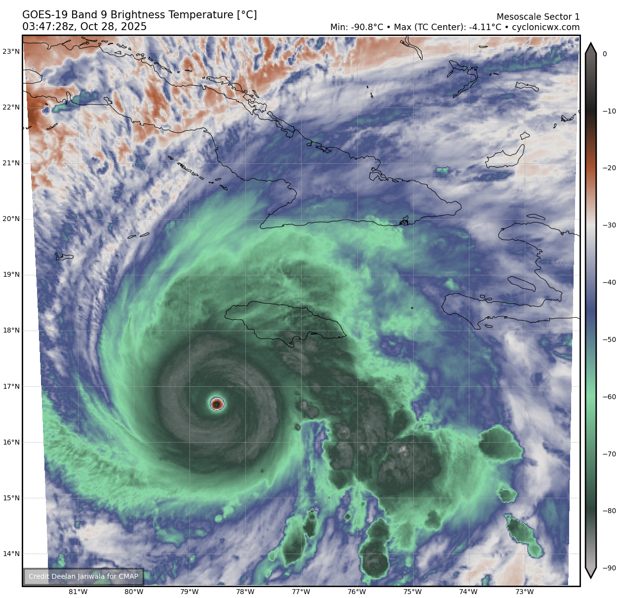
I can't recall ever seeing such a perfectly consistent eye shape for so long.
7 likes
-
disassociated_vort
- Tropical Wave

- Posts: 3
- Joined: Mon Oct 06, 2025 1:56 pm
Re: NATL: MELISSA - Hurricane - Discussion
Curious about a litte S2K history. Has there ever been a thread that hits triple digits in pages before landfall? Always impressed by this forum and collective knowledge.
4 likes
-
Kingarabian

- S2K Supporter
- Posts: 16378
- Joined: Sat Aug 08, 2009 3:06 am
- Location: Honolulu, Hawaii
Re: NATL: MELISSA - Hurricane - Discussion
Loving the IR pics guys.
Jamaica: Thoughts and Prayers. Truly devastating
Jamaica: Thoughts and Prayers. Truly devastating
1 likes
RIP Kobe Bryant
-
InfernoFlameCat

- Category 5

- Posts: 2127
- Age: 22
- Joined: Mon Dec 14, 2020 10:52 am
- Location: Buford, GA
Re: NATL: MELISSA - Hurricane - Discussion
I do think this will surpass Milton at this rate
2 likes
I am by no means a professional. DO NOT look at my forecasts for official information or make decisions based on what I post.
Goal: to become a registered expert over tropical and subtropical cyclones.
Goal: to become a registered expert over tropical and subtropical cyclones.
-
Hurricane Mike
- Category 2

- Posts: 675
- Joined: Tue Apr 10, 2018 7:44 am
Re: NATL: MELISSA - Hurricane - Discussion
Video on Melissa
https://www.youtube.com/watch?v=KY03cvx7R_0
https://www.youtube.com/watch?v=KY03cvx7R_0
Last edited by Hurricane Mike on Mon Oct 27, 2025 10:41 pm, edited 1 time in total.
0 likes
-
eastcoastFL

- Category 5
- Posts: 3996
- Age: 44
- Joined: Thu Apr 12, 2007 12:29 pm
- Location: Palm City, FL
Re: NATL: MELISSA - Hurricane - Discussion
disassociated_vort wrote:Curious about a litte S2K history. Has there ever been a thread that hits triple digits in pages before landfall? Always impressed by this forum and collective knowledge.
I'm pretty sure. The only reason this isn't higher is because it's not a CONUS threat.
3 likes
Personal Forecast Disclaimer:
The posts in this forum are NOT official forecast and should not be used as such. They are just the opinion of the poster and may or may not be backed by sound meteorological data. They are NOT endorsed by any professional institution or storm2k.org. For official information, please refer to the NHC and NWS products.
The posts in this forum are NOT official forecast and should not be used as such. They are just the opinion of the poster and may or may not be backed by sound meteorological data. They are NOT endorsed by any professional institution or storm2k.org. For official information, please refer to the NHC and NWS products.
-
InfernoFlameCat
- Category 5
- Posts: 2127
- Age: 22
- Joined: Mon Dec 14, 2020 10:52 am
- Location: Buford, GA
Re: NATL: MELISSA - Hurricane - Discussion
disassociated_vort wrote:Curious about a litte S2K history. Has there ever been a thread that hits triple digits in pages before landfall? Always impressed by this forum and collective knowledge.
Irma did I believe
1 likes
I am by no means a professional. DO NOT look at my forecasts for official information or make decisions based on what I post.
Goal: to become a registered expert over tropical and subtropical cyclones.
Goal: to become a registered expert over tropical and subtropical cyclones.

Re: NATL: MELISSA - Hurricane - Discussion
Reminder:
Teban54 wrote:Keep in mind that this AF plane's extrap pressure on the last pass was too low: it was extrapolating 903 mb, when two dropsonades from different aircraft confirmed 907 mb.
So hold your breath once you see the pressure, until the dropsonade confirms it.
0 likes
TC naming lists: retirements and intensity
Most aggressive Advisory #1's in North Atlantic (cr. kevin for starting the list)
Most aggressive Advisory #1's in North Atlantic (cr. kevin for starting the list)
-
eastcoastFL
- Category 5
- Posts: 3996
- Age: 44
- Joined: Thu Apr 12, 2007 12:29 pm
- Location: Palm City, FL
Re: NATL: MELISSA - Hurricane - Discussion
Teban54 wrote:Reminder:Teban54 wrote:Keep in mind that this AF plane's extrap pressure on the last pass was too low: it was extrapolating 903 mb, when two dropsonades from different aircraft confirmed 907 mb.
So hold your breath once you see the pressure, until the dropsonade confirms it.
What is that supposed to mean? The NHC went with the 903mb.
0 likes
Personal Forecast Disclaimer:
The posts in this forum are NOT official forecast and should not be used as such. They are just the opinion of the poster and may or may not be backed by sound meteorological data. They are NOT endorsed by any professional institution or storm2k.org. For official information, please refer to the NHC and NWS products.
The posts in this forum are NOT official forecast and should not be used as such. They are just the opinion of the poster and may or may not be backed by sound meteorological data. They are NOT endorsed by any professional institution or storm2k.org. For official information, please refer to the NHC and NWS products.
-
Keldeo1997
- Category 2
- Posts: 688
- Joined: Fri Oct 11, 2019 11:35 pm
-
Hurricane2022

- Category 5
- Posts: 2092
- Joined: Tue Aug 23, 2022 11:38 pm
- Location: Araçatuba, Brazil
Re: NATL: MELISSA - Hurricane - Discussion
AI-VIS Dapiya

1 likes
Sorry for the bad English sometimes...!
For reliable and detailed information for any meteorological phenomenon, please consult the National Hurricane Center, Joint Typhoon Warning Center , or your local Meteo Center.
--------
ECCE OMNIA NOVA FACIAM (Ap 21,5).
For reliable and detailed information for any meteorological phenomenon, please consult the National Hurricane Center, Joint Typhoon Warning Center , or your local Meteo Center.
--------
ECCE OMNIA NOVA FACIAM (Ap 21,5).
Re: NATL: MELISSA - Hurricane - Discussion
eastcoastFL wrote:Teban54 wrote:Reminder:Teban54 wrote:Keep in mind that this AF plane's extrap pressure on the last pass was too low: it was extrapolating 903 mb, when two dropsonades from different aircraft confirmed 907 mb.
So hold your breath once you see the pressure, until the dropsonade confirms it.
What is that supposed to mean? The NHC went with the 903mb.
Oh sorry, that was a quote I posted before the last pass that was already completed. The 907 mb was from two passes ago.
1 likes
TC naming lists: retirements and intensity
Most aggressive Advisory #1's in North Atlantic (cr. kevin for starting the list)
Most aggressive Advisory #1's in North Atlantic (cr. kevin for starting the list)


Re: NATL: MELISSA - Hurricane - Discussion
033830 1649N 07830W 6967 02817 //// +102 //// 099115 119 101 007 01
033900 1648N 07830W 6968 02754 //// +094 //// 098130 135 117 032 01
033930 1647N 07830W 6956 02682 //// +092 //// 098141 144 137 033 01
034000 1645N 07831W 6958 02571 //// +098 //// 098148 152 156 045 01
034030 1644N 07831W 6941 02463 //// +116 //// 097122 151 164 016 01
034100 1643N 07831W 6978 02331 //// +172 //// 096066 097 158 002 01
034130 1641N 07831W 6955 02312 //// +175 //// 089024 049 055 002 01
034200 1639N 07831W 6978 02272 //// +192 //// 313008 019 018 003 01
034230 1637N 07830W 6958 02305 //// +187 //// 260034 047 026 003 05
034300 1636N 07831W 6996 02290 //// +158 //// 270061 068 /// /// 05
1 likes
-
CrazyC83
- Professional-Met

- Posts: 34316
- Joined: Tue Mar 07, 2006 11:57 pm
- Location: Deep South, for the first time!
Re: NATL: MELISSA - Hurricane - Discussion
The heights are down slightly from last pass. Now we wait for the drop...
4 likes

Re: NATL: MELISSA - Hurricane - Discussion
disassociated_vort wrote:Curious about a litte S2K history. Has there ever been a thread that hits triple digits in pages before landfall? Always impressed by this forum and collective knowledge.
yeah, I think Ian was over 250 pages before landfall at least and others that threatened CONUS were over 100 pages...
if this was ANY threat to CONUS at all, this thread would be closer to 200 pages at least right now
Last edited by CronkPSU on Mon Oct 27, 2025 10:48 pm, edited 1 time in total.
2 likes
Just like Jon Snow..."I know nothing" except what I know, and most of what I know is gathered by the fine people of the NHC
Re: NATL: MELISSA - Hurricane - Discussion
From the heights it looks like the pressure is not dropping.
1 likes

Re: NATL: MELISSA - Hurricane - Discussion
disassociated_vort wrote:Curious about a litte S2K history. Has there ever been a thread that hits triple digits in pages before landfall? Always impressed by this forum and collective knowledge.
Yes when big hurricane threat to landfall in usa like katrina, harvey, irma, ian
0 likes
-
Hurricane2022
- Category 5
- Posts: 2092
- Joined: Tue Aug 23, 2022 11:38 pm
- Location: Araçatuba, Brazil
Re: NATL: MELISSA - Hurricane - Discussion
Looks like she has reached her big peak, as both IR and Radar are showing strong hints of an EWRC.
0 likes
Sorry for the bad English sometimes...!
For reliable and detailed information for any meteorological phenomenon, please consult the National Hurricane Center, Joint Typhoon Warning Center , or your local Meteo Center.
--------
ECCE OMNIA NOVA FACIAM (Ap 21,5).
For reliable and detailed information for any meteorological phenomenon, please consult the National Hurricane Center, Joint Typhoon Warning Center , or your local Meteo Center.
--------
ECCE OMNIA NOVA FACIAM (Ap 21,5).
-
Keldeo1997
- Category 2
- Posts: 688
- Joined: Fri Oct 11, 2019 11:35 pm
-
InfernoFlameCat
- Category 5
- Posts: 2127
- Age: 22
- Joined: Mon Dec 14, 2020 10:52 am
- Location: Buford, GA
Re: NATL: MELISSA - Hurricane - Discussion
Hurricane2022 wrote:Looks like she has reached her big peak, as both IR and Radar are showing strong hints of an EWRC.
The plane doesn’t show any sign of a double wind maxima
1 likes
I am by no means a professional. DO NOT look at my forecasts for official information or make decisions based on what I post.
Goal: to become a registered expert over tropical and subtropical cyclones.
Goal: to become a registered expert over tropical and subtropical cyclones.
Who is online
Users browsing this forum: No registered users and 61 guests