NATL: MELISSA - Hurricane - Discussion

Current storms and invests:

Moderators: hurricanetrack, S2k Moderators


The posts in this forum are NOT official forecasts and should not be used as such. They are just the opinion of the poster and may or may not be backed by sound meteorological data. They are NOT endorsed by any professional institution or STORM2K. For official information, please refer to products from the National Hurricane Center and National Weather Service.

Help Support Storm2K
Message
Author
CrazyC83
Professional-Met
Professional-Met
Posts: 34243
Joined: Tue Mar 07, 2006 11:57 pm
Location: Deep South, for the first time!

Re: NATL: MELISSA - Hurricane - Discussion

#2081 Postby CrazyC83 » Mon Oct 27, 2025 11:12 pm

Stormgodess wrote:Can we expect an increase in storm surge forcasts for Mellisa as she strengthens? I realize topography plays a huge role, but I can't help but remember Katrina's 20ft + surge in Mississippi and wonder if 13ft for Melissa is lacking?


Katrina was much larger in size though, especially after the ERC. Now, if Melissa misses Jamaica, goes into an ERC and expands out, then that could be a major issue for Cuba. That is what happened in 1932.
7 likes   

Fancy1002
Category 1
Category 1
Posts: 322
Joined: Sun Dec 25, 2022 3:47 pm

Re: NATL: MELISSA - Hurricane - Discussion

#2082 Postby Fancy1002 » Mon Oct 27, 2025 11:13 pm

Please tell me recon is going to do one last pass. It can’t leave without us knowing for sure.
6 likes   

dukeblue219
S2K Supporter
S2K Supporter
Posts: 553
Joined: Fri Sep 30, 2016 3:52 pm

Re: NATL: MELISSA - Hurricane - Discussion

#2083 Postby dukeblue219 » Mon Oct 27, 2025 11:15 pm

Fancy1002 wrote:Please tell me recon is going to do one last pass. It can’t leave without us knowing for sure.

Know what for sure? There's always nagging interest in one... more... pass!
0 likes   

User avatar
KirbyDude25
Tropical Storm
Tropical Storm
Posts: 159
Age: 20
Joined: Mon Sep 20, 2021 8:03 am
Location: Westfield, New Jersey

Re: NATL: MELISSA - Hurricane - Discussion

#2084 Postby KirbyDude25 » Mon Oct 27, 2025 11:15 pm

Fancy1002 wrote:Please tell me recon is going to do one last pass. It can’t leave without us knowing for sure.

The TCPOD lists it as being on station until 5:30Z, or about 75 minutes from now, and it's turning westward on Flightradar24. To me, that suggests it's going in for one more pass
5 likes   
New Jersey, Rutgers '27
Irene 2011 | Sandy 2012 | Fay 2020 | Isaias 2020 | Ida 2021

User avatar
Travorum
Category 2
Category 2
Posts: 618
Joined: Tue Sep 05, 2023 9:36 am
Location: Dunedin, FL

Re: NATL: MELISSA - Hurricane - Discussion

#2085 Postby Travorum » Mon Oct 27, 2025 11:15 pm

Again this doesn't mean anything as Melissa's intensity is well below what it's appearance would suggest, but ADT CI# just hit 8.5 for the first time ever in the Atlantic:

----- Current Analysis -----
Date : 28 OCT 2025 Time : 034020 UTC
Lat : 16:37:12 N Lon : 78:30:36 W


CI# /Pressure/ Vmax
8.5 / 871.5mb/185.0kt


Final T# Adj T# Raw T#
8.5 8.6 8.6

Estimated radius of max. wind based on IR : 15 km

Center Temp : +19.2C Cloud Region Temp : -81.4C
Last edited by Travorum on Mon Oct 27, 2025 11:23 pm, edited 1 time in total.
13 likes   

Tekken_Guy
Tropical Storm
Tropical Storm
Posts: 150
Joined: Fri Sep 01, 2017 8:08 pm

Re: NATL: MELISSA - Hurricane - Discussion

#2086 Postby Tekken_Guy » Mon Oct 27, 2025 11:17 pm

All I want to know is if Melissa will join the 800 club or not.
7 likes   

User avatar
Jr0d
S2K Supporter
S2K Supporter
Posts: 1468
Joined: Tue Aug 27, 2019 10:52 am
Location: Cayo Hueso

Re: NATL: MELISSA - Hurricane - Discussion

#2087 Postby Jr0d » Mon Oct 27, 2025 11:17 pm

161kts is about 185mph.

That in my amatuer is a reasonable estimation of max sustained surface winds, especially given all the other information.

Even if the drop measured a gust, no reason to believe there are not sustained winds that high reaching the surface.
3 likes   

Fancy1002
Category 1
Category 1
Posts: 322
Joined: Sun Dec 25, 2022 3:47 pm

Re: NATL: MELISSA - Hurricane - Discussion

#2088 Postby Fancy1002 » Mon Oct 27, 2025 11:17 pm

dukeblue219 wrote:
Fancy1002 wrote:Please tell me recon is going to do one last pass. It can’t leave without us knowing for sure.

Know what for sure? There's always nagging interest in one... more... pass!

To know for sure whether it is reached sub 900 pressure. Even if it falls below to 899 or 898 over the next 30 minutes to an hour, it could start to rise before the next recon mission gets there. I would prefer that we have direct evidence rather than speculations.
6 likes   

SconnieCane
Category 5
Category 5
Posts: 1013
Joined: Thu Aug 02, 2018 5:29 pm
Location: Madison, WI

Re: NATL: MELISSA - Hurricane - Discussion

#2089 Postby SconnieCane » Mon Oct 27, 2025 11:17 pm

cheezyWXguy wrote:

A convective structure with virtually no outer banding, just a donut core. Melissa certainly has a donut core, but outer banding is much too prominent. More likely to see a structure like that in the open Atlantic than the Caribbean. See Isabel ‘03 as the textbook example.


Beat me to it. A lot of people seem to be under the impression that any intense TC with a symmetrical CDO is "annular," but there's more to it than that.
4 likes   

User avatar
Hurricane2022
Category 5
Category 5
Posts: 1904
Joined: Tue Aug 23, 2022 11:38 pm
Location: Araçatuba, Brazil

Re: NATL: MELISSA - Hurricane - Discussion

#2090 Postby Hurricane2022 » Mon Oct 27, 2025 11:19 pm

1 likes   
Sorry for the bad English sometimes...!
For reliable and detailed information for any meteorological phenomenon, please consult the National Hurricane Center, Joint Typhoon Warning Center , or your local Meteo Center.

--------

ECCE OMNIA NOVA FACIAM (Ap 21,5).

zzzh
Category 5
Category 5
Posts: 1024
Joined: Thu Sep 02, 2021 1:13 pm

Re: NATL: MELISSA - Hurricane - Discussion

#2091 Postby zzzh » Mon Oct 27, 2025 11:19 pm

Image
Those CDG's in the middle ring of the CDO reminds me of Patricia
6 likes   

CrazyC83
Professional-Met
Professional-Met
Posts: 34243
Joined: Tue Mar 07, 2006 11:57 pm
Location: Deep South, for the first time!

Re: NATL: MELISSA - Hurricane - Discussion

#2092 Postby CrazyC83 » Mon Oct 27, 2025 11:20 pm

Unless an unscheduled mission is added, we will have about a 5 1/2 hour gap without Recon data in the storm. This plane leaves around 0530Z, and the next plane departs at 0800Z to arrive around 1100Z.
3 likes   

Fancy1002
Category 1
Category 1
Posts: 322
Joined: Sun Dec 25, 2022 3:47 pm

Re: NATL: MELISSA - Hurricane - Discussion

#2093 Postby Fancy1002 » Mon Oct 27, 2025 11:21 pm

Is that a fourth CDC ring? How does that make sense? Also, I might be using the wrong term.
2 likes   

User avatar
Hurrilurker
Category 2
Category 2
Posts: 737
Joined: Mon Jun 09, 2003 3:32 pm
Location: San Francisco, CA

Re: NATL: MELISSA - Hurricane - Discussion

#2094 Postby Hurrilurker » Mon Oct 27, 2025 11:22 pm

Ptarmigan wrote:Jamaica in November 1909 had 135 inches of rainfall.
https://ui.adsabs.harvard.edu/abs/2022A ... K/abstract

The slow movement of Melissa is going to dump heavy rain over a large area.

I would think they're already getting lashed pretty good, CDO still offshore but a ton of intense convection bubbling over the island right now. Vegetation and soil will already be loose by the time the Cat 4+ winds get there.
2 likes   

Hurricane Mike
Category 2
Category 2
Posts: 671
Joined: Tue Apr 10, 2018 7:44 am

Re: NATL: MELISSA - Hurricane - Discussion

#2095 Postby Hurricane Mike » Mon Oct 27, 2025 11:24 pm

I am guessing about 180-185 mph is quite possibly the current intensity.
4 likes   

Exalt
Category 1
Category 1
Posts: 344
Joined: Thu Nov 26, 2015 10:55 pm

Re: NATL: MELISSA - Hurricane - Discussion

#2096 Postby Exalt » Mon Oct 27, 2025 11:25 pm

This thing looks like a history-making WPAC typhoon but instead of the Philippines it’s the Caribbean
3 likes   

User avatar
Owasso
Category 1
Category 1
Posts: 320
Joined: Sat Aug 22, 2020 11:14 pm
Location: Chicago, Illinois

Re: NATL: MELISSA - Hurricane - Discussion

#2097 Postby Owasso » Mon Oct 27, 2025 11:25 pm

Hurrilurker wrote:
Ptarmigan wrote:Jamaica in November 1909 had 135 inches of rainfall.
https://ui.adsabs.harvard.edu/abs/2022A ... K/abstract

The slow movement of Melissa is going to dump heavy rain over a large area.

I would think they're already getting lashed pretty good, CDO still offshore but a ton of intense convection bubbling over the island right now. Vegetation and soil will already be loose by the time the Cat 4+ winds get there.


From what I was seeing earlier today, downed trees blocking roads and collapsing house roofs.
1 likes   

User avatar
Owasso
Category 1
Category 1
Posts: 320
Joined: Sat Aug 22, 2020 11:14 pm
Location: Chicago, Illinois

Re: NATL: MELISSA - Hurricane - Discussion

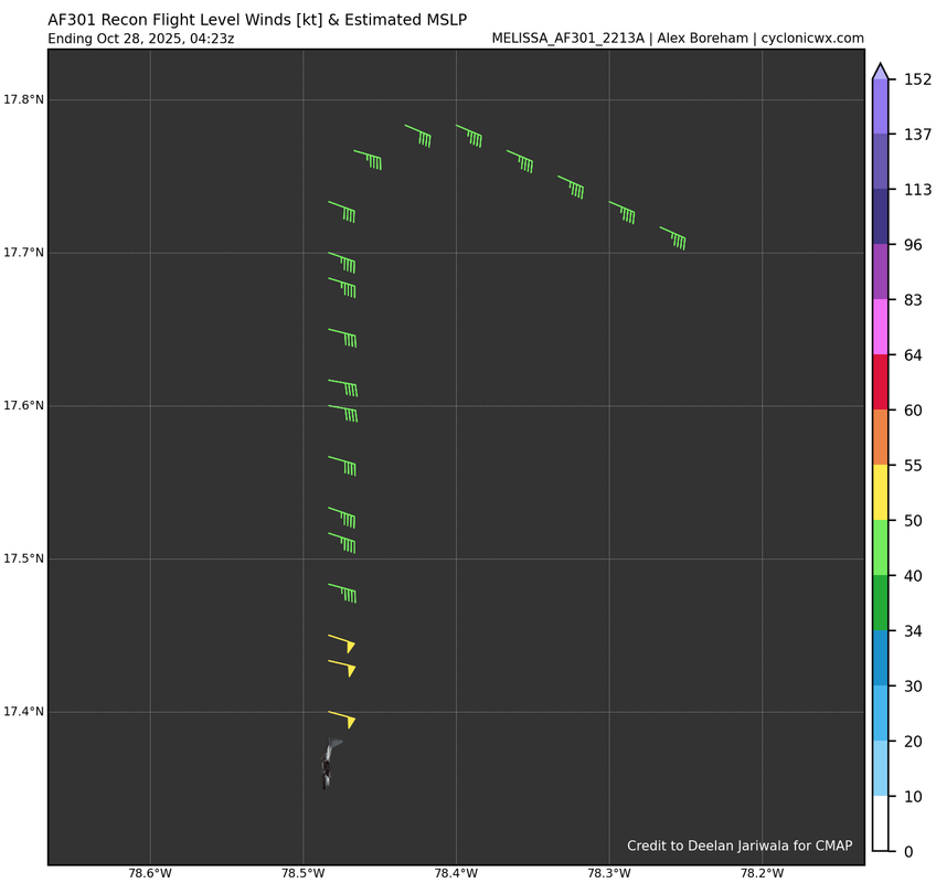
#2098 Postby Owasso » Mon Oct 27, 2025 11:26 pm

Image

Here we go. Another north to south pass.
6 likes   

SconnieCane
Category 5
Category 5
Posts: 1013
Joined: Thu Aug 02, 2018 5:29 pm
Location: Madison, WI

Re: NATL: MELISSA - Hurricane - Discussion

#2099 Postby SconnieCane » Mon Oct 27, 2025 11:33 pm

The subtle (within the cone/margin of error) but definite west-of-track motion today must have given Josh fits, especially if he set up in Treasure Beach. Depending on how much of an east of due north angle it takes, he may have to be at Savanna la Mar or even further west to get the eyewall and it looks like there aren't any really main roads out of Treasure Beach. They're all narrow and either go through mountain passes or right along the coast, so they may have already become impassable earlier today.
1 likes   

User avatar
Owasso
Category 1
Category 1
Posts: 320
Joined: Sat Aug 22, 2020 11:14 pm
Location: Chicago, Illinois

Re: NATL: MELISSA - Hurricane - Discussion

#2100 Postby Owasso » Mon Oct 27, 2025 11:35 pm

132kt FL, not fully through the eyewall though
0 likes   


Return to “Active Storms/Invests - Atlantic/EastPAC/CentralPAC/MED”

Who is online

Users browsing this forum: kevin, Teban54 and 203 guests