
WPAC: FUNG-WONG - Post-Tropical - Discussion
Moderator: S2k Moderators
-
cycloneye

- Admin

- Posts: 149686
- Age: 69
- Joined: Thu Oct 10, 2002 10:54 am
- Location: San Juan, Puerto Rico
Re: WPAC: 32W - Tropical Depression - Discussion
1 likes
Visit the Caribbean-Central America Weather Thread where you can find at first post web cams,radars
and observations from Caribbean basin members Click Here
and observations from Caribbean basin members Click Here
-
mrbagyo

- Category 5

- Posts: 3990
- Age: 33
- Joined: Thu Apr 12, 2012 9:18 am
- Location: 14.13N 120.98E
- Contact:
Re: WPAC: 32W - Tropical Depression - Discussion

Its cloud cover is freaking huge
2 likes
The posts in this forum are NOT official forecast and should not be used as such. They are just the opinion of the poster and may or may not be backed by sound meteorological data. They are NOT endorsed by any professional institution or storm2k.org. For official information, please refer to RSMC, NHC and NWS products.
-
cycloneye
- Admin
- Posts: 149686
- Age: 69
- Joined: Thu Oct 10, 2002 10:54 am
- Location: San Juan, Puerto Rico
Re: WPAC: 32W - Tropical Depression - Discussion
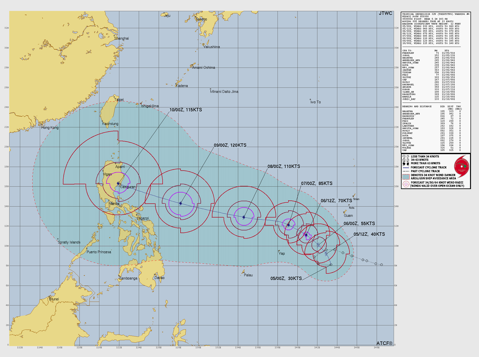
SUMMARY:
INITIAL POSITION: 8.1N 143.4E
INITIAL INTENSITY: 30 KTS
GEOGRAPHIC REFERENCE: 51 NM NORTHWEST OF WOLEAI
MOVEMENT PAST 6 HOURS: EASTWARD AT 13 KTS
SIGNIFICANT WAVE HEIGHT: 12 FEET
SATELLITE ANALYSIS, INITIAL POSITION AND INTENSITY DISCUSSION:
ANIMATED MULTISPECTRAL SATELLITE IMAGERY (MSI) DEPICTS A FULLY
EXPOSED LOW-LEVEL CIRCULATION CENTER (LLCC) WITH CONVECTIVE BANDING
WRAPPING AROUND THE BROAD AND EXPANSIVE TROPICAL DEPRESSION (TD).
DRY AIR REVEALS THE LOW-LEVEL CLOUD BANDS NOW EVIDENT IN DAYLIGHT.
WATER VAPOR IMAGERY REVEALS DRY AIR TO THE NORTHWEST OF THE
CIRCULATION AND TO THE SOUTHEAST. THE INITIAL POSITION IS PLACED
WITH HIGH CONFIDENCE BASED ON A 042342 METOP-C ASCAT IMAGE
DEPICTING AN ELONGATED CIRCULATION ON A WEST-EAST AXIS. THE INITIAL
INTENSITY OF 30 KTS IS ASSESSED WITH HIGH CONFIDENCE BASED ON THE
AFOREMENTIONED SCATTEROMETRY AND THE AGENCY AND OBJECTIVE FIXES
LISTED BELOW, NOTING THE 5-10KT LOW BIAS OF METOP-C.
INITIAL WIND RADII BASIS: NOT APPLICABLE (THERE ARE NO INITIAL WIND
RADII).
CURRENT STEERING MECHANISM: THE SUBTROPICAL RIDGE TO THE NORTH
AGENCY DVORAK AND AUTOMATED FIXES:
PGTW: T2.0 - 30 KTS
RJTD: T1.5 - 25 KTS
KNES: T2.0 - 30 KTS
CIMSS SATCON: 33 KTS AT 042100Z
CIMSS ADT: 34 KTS AT 042030Z
CIMSS AIDT: 34 KTS AT 042030Z
CIMSS D-MINT: 23 KTS AT 042215Z
CIMSS D-PRINT: 19 KTS AT 050020Z
FORECASTER ASSESSMENT OF CURRENT ENVIRONMENT: MARGINALLY FAVORABLE
VWS: 0-5 KTS
SST: 29-30 CELSIUS
OUTFLOW: MODERATE POLEWARD AND EQUATORWARD
ANALYSIS CONFIDENCE:
INITIAL POSITION: HIGH
INITIAL INTENSITY: HIGH
INITIAL WIND RADII: NOT APPLICABLE
3. FORECAST REASONING.
SIGNIFICANT FORECAST CHANGES: THERE ARE NO SIGNIFICANT CHANGES TO
THE FORECAST FROM THE PREVIOUS WARNING.
FORECAST DISCUSSION: THE TRACK FORECAST FOR TD 32W WILL REMAIN
COMPLEX AS THE SYSTEM CONTINUES TO CONSOLIDATE OVER THE NEXT 12
HOURS, AND DURING THAT TIME IRREGULAR MOTION CAN BE ANTICIPATED
DURING A QUASI-STATIONARY PERIOD. ONCE WELL-DEFINED AND COMPACT,
THE SYSTEM WILL COME UNDER THE PRIMARY STEERING INFLUENCE OF THE
SUBTROPICAL RIDGE TO THE NORTH, TRACKING NORTHWESTWARD FOR THE NEXT
48 HOURS. THE STEERING ENVIRONMENT WILL SHIFT SLIGHTLY DUE TO
INFLUENCE OF A WEAKENING RIDGE OVER THE SOUTH CHINA SEA, CAUSING TD
32W TO TRACK WEST-NORTHWESTWARD FOR THE REMAINDER OF THE FORECAST
PERIOD, MAKING LANDFALL ON LUZON IMMEDIATELY PRIOR TO TAU 120. IN
THE EARLY-TERM, THE SYSTEM WILL STRUGGLE TO INTENSIFY DUE TO DRY
AIR EMBEDDED WITHIN THE CIRCULATION CENTER, HOWEVER AS THE SYSTEM
CONSOLIDATES AND MOISTENS, RAPID INTENSIFICATION IS ANTICIPATED DUE
TO FAVORABLY LOW VERTICAL WIND SHEAR, WARM SEA SURFACE
TEMPERATURES, AND EXPANSIVE OUTFLOW, ALLOWING FOR A PEAK INTENSITY
OF 120KTS BY TAU 96. SLIGHT WEAKENING WILL OCCUR BY TAU 120 DUE TO
TOPOGRAPHIC INTERACTION WITH MAINLAND LUZON.
MODEL DISCUSSION: DETERMINISTIC MODEL GUIDANCE CONTINUES TO HAVE A
LARGE SPREAD THROUGHOUT THE FORECAST PERIOD SPANNING APPROXIMATELY
300NM BY TAU 120. THE CROSS-TRACK SPREAD HAS CLOSED SLIGHTLY SINCE
THE PREVIOUS WARNING, HOWEVER THE LOW CONFIDENCE IN THE TRACK
FORECAST REMAINS THE SAME. THE UNCERTAINTY OF EXACTLY WHERE THE
SYSTEM WILL DEVELOP IS DIRECTLY CORRELATED TO THE MODEL
DISAGREEMENT, BUT THERE IS MORE CERTAINTY IN THE 00Z POSITION AND
INTENSITY WHICH WILL ALLOW FOR BETTER CONTRAST AND COMPARISON WITH
THE MODEL SOLUTIONS. GFS CONTINUES TO GIVE THE FALSE APPEARANCE
THAT THERE IS A VORTICITY MAXIMUM TO THE NORTHEAST OF THE BEST
TRACK POSITION WHILE OTHER MODELS, SUCH AS ECMWF, AND REAL-TIME
DATA, SUCH AS THE AFOREMENTIONED 042342Z METOP-C ASCAT IMAGERY,
DISAGREE. THE INTENSITY GUIDANCE IS IN MODERATE AGREEMENT,
INDICATING PEAK INTENSITIES BETWEEN 110-130KTS AT TAU 84. RAPID
INTENSIFICATION GUIDANCE FROM JTWC SHIPS STRONGLY SUGGESTS RAPID
INTENSIFICATION TO OCCUR THROUGH TAU 36-48.
FORECAST CONFIDENCE:
TRACK 00-72 HR: LOW
TRACK 72-120 HR: LOW
INTENSITY 00-72 HR: MEDIUM
INTENSITY 72-120 HR: MEDIUM//

0 likes
Visit the Caribbean-Central America Weather Thread where you can find at first post web cams,radars
and observations from Caribbean basin members Click Here
and observations from Caribbean basin members Click Here
-
WaveBreaking

- Category 2

- Posts: 727
- Joined: Sun Jun 30, 2024 11:33 am
- Location: US
Re: WPAC: 32W - Tropical Depression - Discussion
Very sprawling storm w lots of banding. All that's needed is convection near the core and it'll take off.

0 likes
I am NOT a professional meteorologist, so take all of my posts with a grain of salt. My opinions are mine and mine alone.
-
dexterlabio
- Category 5
- Posts: 3517
- Joined: Sat Oct 24, 2009 11:50 pm
Re: WPAC: 90W - Tropical Depression - Discussion
1900hurricane wrote:1900hurricane wrote:I don't think that will be our final circulation. Watch for propagation/reformation southeastwards near where the more robust convection is setting up. I think we're about to have quite the TC on our hands here, perhaps the strongest in the world for the year of 2025.
After watching the circulation more (there was an outflow boundary crossing it at the time), I am more convinced that it our player, though I still think some propagation could tug it around a little over the next 24 hours or so, perhaps in something resembling a rough counterclockwise loop around/just under 10°N south of Guam.
No changes to general expectations though. Hold on to your butts.
Spot on prediction. PAGASA picked up the center relocation or tugging to the SE.
0 likes
Personal Forecast Disclaimer:
The posts in this forum are NOT official forecast and should not be used as such. They are just the opinion of the poster and may or may not be backed by sound meteorological data. They are NOT endorsed by any professional institution or storm2k.org. For official information, please refer to the NHC and NWS products.
The posts in this forum are NOT official forecast and should not be used as such. They are just the opinion of the poster and may or may not be backed by sound meteorological data. They are NOT endorsed by any professional institution or storm2k.org. For official information, please refer to the NHC and NWS products.
-
mrbagyo
- Category 5
- Posts: 3990
- Age: 33
- Joined: Thu Apr 12, 2012 9:18 am
- Location: 14.13N 120.98E
- Contact:
Re: WPAC: 32W - Tropical Depression - Discussion

1 likes
The posts in this forum are NOT official forecast and should not be used as such. They are just the opinion of the poster and may or may not be backed by sound meteorological data. They are NOT endorsed by any professional institution or storm2k.org. For official information, please refer to RSMC, NHC and NWS products.

Re: WPAC: 32W - Tropical Depression - Discussion
WaveBreaking wrote:Very sprawling storm w lots of banding. All that's needed is convection near the core and it'll take off.
https://i.imgur.com/vVwbIRT.gif
This sprawling structure is probably going to hold it back IMO. HAFS has been trending towards a large core for the last day or so, which would make those crazy high intensity estimates far less likely. Could be very similar to Ragasa in structure and peak intensity (900-910 mb, no greater than 150-155 kt).
Unfortunately, its likely large size as a mature TC will make it a much bigger problem for wherever it hits in the Philippines.
0 likes
Irene '11 Sandy '12 Hermine '16 5/15/2018 Derecho Fay '20 Isaias '20 Elsa '21 Henri '21 Ida '21
I am only a meteorology enthusiast who knows a decent amount about tropical cyclones. Look to the professional mets, the NHC, or your local weather office for the best information.
I am only a meteorology enthusiast who knows a decent amount about tropical cyclones. Look to the professional mets, the NHC, or your local weather office for the best information.
-
dexterlabio
- Category 5
- Posts: 3517
- Joined: Sat Oct 24, 2009 11:50 pm
Re: WPAC: 32W - Tropical Depression - Discussion
Core building seems to be starting atm. While I do agree its enormous size will be the one holding it back, a sprawling and very intense typhoon isn't unprecedented (Tip).
0 likes
Personal Forecast Disclaimer:
The posts in this forum are NOT official forecast and should not be used as such. They are just the opinion of the poster and may or may not be backed by sound meteorological data. They are NOT endorsed by any professional institution or storm2k.org. For official information, please refer to the NHC and NWS products.
The posts in this forum are NOT official forecast and should not be used as such. They are just the opinion of the poster and may or may not be backed by sound meteorological data. They are NOT endorsed by any professional institution or storm2k.org. For official information, please refer to the NHC and NWS products.


Re: WPAC: 32W - Tropical Depression - Discussion
200mb vort is coming together quickly with surroundings clearing out.
https://tropic.ssec.wisc.edu/real-time/ ... oom=&time=
Low level vort seems to be entraining all the high TPW air in the WPAC
It may ingest some dry air in about 36 to 48hrs.
https://tropic.ssec.wisc.edu/real-time/ ... anim=html5
https://rammb-data.cira.colostate.edu/t ... 050900.png
Shear vector appears to be from south to north.
No significant convection near the CoC which is estimated to be at 9N 142.5E at 11:00Z via ADT
JTWC puts it at 8.32N 144.44E at 11:30Z
Watching some convection to the west of the CoC if it moves into upshear-left.
https://tropic.ssec.wisc.edu/real-time/adt/odt32W.html
Magnificent outflow presentation.
https://rammb-data.cira.colostate.edu/t ... 050236.jpg
All models have a bead on the main island of the Philippines.
HFSA is the strongest with forecasted 155knot winds at landfall.
Other models not as aggressive.
https://rammb-data.cira.colostate.edu/t ... 050600.png
Some mid-level drying may ensue in 48hrs which could kick off an EWRC.
Probability of RI seems to have backed off some since yesterday's estimate
https://tropic.ssec.wisc.edu/real-time/ai-ri/
Landfall estimated 11/10/25 00:00Z
https://www.metoc.navy.mil/jtwc/products/wp3225.gif
0 likes
-
cycloneye
- Admin
- Posts: 149686
- Age: 69
- Joined: Thu Oct 10, 2002 10:54 am
- Location: San Juan, Puerto Rico
Re: WPAC: 32W - Tropical Depression - Discussion
Still stucked as TD so the hype is waning. It should had been a Tropical Storm from model runs 24 hours ago.
32W THIRTYTWO 251105 1200 9.0N 142.6E WPAC 30 998
0 likes
Visit the Caribbean-Central America Weather Thread where you can find at first post web cams,radars
and observations from Caribbean basin members Click Here
and observations from Caribbean basin members Click Here

Re: WPAC: 32W - Tropical Depression - Discussion
Latest Ascat pass circulation is near 8.2N, 142.7E
0 likes
ヤンデレ女が寝取られるているのを見たい!!!
ECMWF ensemble NWPAC plots: https://ecmwfensnwpac.imgbb.com/
Multimodel NWPAC plots: https://multimodelnwpac.imgbb.com/
GFS Ensemble NWPAC plots (16 & 35 day forecast): https://gefsnwpac.imgbb.com/
Plots updated automatically
ECMWF ensemble NWPAC plots: https://ecmwfensnwpac.imgbb.com/
Multimodel NWPAC plots: https://multimodelnwpac.imgbb.com/
GFS Ensemble NWPAC plots (16 & 35 day forecast): https://gefsnwpac.imgbb.com/
Plots updated automatically
-
cycloneye
- Admin
- Posts: 149686
- Age: 69
- Joined: Thu Oct 10, 2002 10:54 am
- Location: San Juan, Puerto Rico
Re: WPAC: 32W - Tropical Depression - Discussion
0 likes
Visit the Caribbean-Central America Weather Thread where you can find at first post web cams,radars
and observations from Caribbean basin members Click Here
and observations from Caribbean basin members Click Here
-
cycloneye
- Admin
- Posts: 149686
- Age: 69
- Joined: Thu Oct 10, 2002 10:54 am
- Location: San Juan, Puerto Rico
Re: WPAC: 32W - Tropical Depression - Discussion
Down in peak from 120 kt to 110 kt and weakens before landfall.

0 likes
Visit the Caribbean-Central America Weather Thread where you can find at first post web cams,radars
and observations from Caribbean basin members Click Here
and observations from Caribbean basin members Click Here
-
dexterlabio
- Category 5
- Posts: 3517
- Joined: Sat Oct 24, 2009 11:50 pm
Re: WPAC: 32W - Tropical Depression - Discussion
Yeah might be too early to say that things are not coming together just yet. Especially now that the central convection is filling in.
0 likes
Personal Forecast Disclaimer:
The posts in this forum are NOT official forecast and should not be used as such. They are just the opinion of the poster and may or may not be backed by sound meteorological data. They are NOT endorsed by any professional institution or storm2k.org. For official information, please refer to the NHC and NWS products.
The posts in this forum are NOT official forecast and should not be used as such. They are just the opinion of the poster and may or may not be backed by sound meteorological data. They are NOT endorsed by any professional institution or storm2k.org. For official information, please refer to the NHC and NWS products.
-
cycloneye
- Admin
- Posts: 149686
- Age: 69
- Joined: Thu Oct 10, 2002 10:54 am
- Location: San Juan, Puerto Rico
Re: WPAC: 32W - Tropical Depression - Discussion
WDPN32 PGTW 051500
MSGID/GENADMIN/JOINT TYPHOON WRNCEN PEARL HARBOR HI//
SUBJ/PROGNOSTIC REASONING FOR TROPICAL DEPRESSION 32W (THIRTYTWO)
WARNING NR 006//
RMKS/
1. FOR METEOROLOGISTS.
2. 6 HOUR SUMMARY AND ANALYSIS.
SUMMARY:
INITIAL POSITION: 8.6N 142.5E
INITIAL INTENSITY: 30 KTS
GEOGRAPHIC REFERENCE: 110 NM NORTHWEST OF WOLEAI
MOVEMENT PAST 6 HOURS: WESTWARD AT 07 KTS
SIGNIFICANT WAVE HEIGHT: 12 FEET
SATELLITE ANALYSIS, INITIAL POSITION AND INTENSITY DISCUSSION:
TROPICAL DEPRESSION (TD) 32W CONTINUES TO SLOWLY ATTEMPT TO
ORGANIZE WITH DEEP CONVECTION MAINLY THROUGHOUT THE WESTERN
SEMICIRCLE OF THE CIRCULATION AS DEPICTED ON ANIMATED ENHANCED
INFRARED (EIR) SATELLITE IMAGERY. THE ENVIRONMENT REMAINS FAVORABLE
FOR CONTINUED DEVELOPMENT WITH WARM SEA SURFACE TEMPERATURES (29 C
TO 30 C), LOW VERTICAL WIND SHEAR (10-15 KTS), AND MODERATE
OUTFLOW, THOUGH THESE FACTORS ARE HINDERED SOMEWHAT BY DRY AIR TO
THE NORTHWEST. THE INITIAL POSITION IS PLACED WITH HIGH CONFIDENCE
BASED ON EIR IMAGERY, AGENCY FIXES, AND A PARTIAL 051226Z METOP-C
ASCAT PASS. THE INITIAL INTENSITY OF 30 KTS IS ASSESSED WITH HIGH
CONFIDENCE BASED ON OBJECTIVE AID ESTIMATES AND THE PREVIOUSLY
MENTIONED 051226Z METOP-C ASCAT PASS.
INITIAL WIND RADII BASIS: OBJECTIVE BEST TRACK
CURRENT STEERING MECHANISM: SUBTROPICAL RIDGE TO THE NORTH
AGENCY DVORAK AND AUTOMATED FIXES:
PGTW: T2.0 - 30 KTS
RJTD: T1.5 - 25 KTS
KNES: T2.0 - 30 KTS
CIMSS ADT: 32 KTS AT 051140Z
CIMSS AIDT: 33 KTS AT 051140Z
CIMSS D-MINT: 25 KTS AT 050806Z
CIMSS D-PRINT: 28 KTS AT 051310Z
FORECASTER ASSESSMENT OF CURRENT ENVIRONMENT: FAVORABLE
VWS: 10-15 KTS
SST: 29-30 CELSIUS
OUTFLOW: MODERATE POLEWARD AND EQUATORWARD
ANALYSIS CONFIDENCE:
INITIAL POSITION: HIGH
INITIAL INTENSITY: HIGH
INITIAL WIND RADII: MEDIUM
3. FORECAST REASONING.
SIGNIFICANT FORECAST CHANGES: THERE ARE NO SIGNIFICANT CHANGES TO
THE FORECAST FROM THE PREVIOUS WARNING.
FORECAST DISCUSSION: TD 32W WILL CONTINUE TO SLOWLY ORGANIZE OVER
THE NEXT 12 HOURS BEFORE TRANSITING FURTHER NORTHWEST UNDER THE
INFLUENCE OF THE SUBTROPICAL RIDGE TO THE NORTH. CONDITIONS REMAIN
FAVORABLE FOR CONSIDERABLE DEVELOPMENT AS THE CIRCULATION
APPROACHES THE EASTERN COAST OF THE PHILIPPINES. THE FORECASTED
ENVIRONMENTAL CONDITIONS ARE CHARACTERIZED BY WARM SEA SURFACE
TEMPERATURES AND LOW VERTICAL WIND SHEAR MAGNITUDES. MAXIMUM
INTENSITIES OF 110 KNOTS ARE EXPECTED OVER THE PHILIPPINE SEA
AROUND TAU 72. AFTERWARDS RELATIVELY DRIER AIR AND SLIGHTLY HIGHER
VERTICAL WIND SHEAR WILL LEAD TO BEGINNING OF A WEAKENING TREND AS
THE CENTER PASSES OVER LUZON BETWEEN TAU 72 AND TAU 120. WEAKENING
WILL PROGRESS QUICKLY, WHILE THE SYSTEM TRANSITS OVER LAND,
RESULTING IN EXPECTED INTENSITY OF 65 KTS.
MODEL DISCUSSION: MODEL GUIDANCE IS FAIRLY SPREAD WITH NAVGEM
DEPICTING A MORE NORTHWESTWARD TRACK AND COAMPS-TC PUSHING THE
SYSTEM FURTHER SOUTH OVER LUZON. CROSS TRACK SPREAD IS OVER 200 NM
FOR A MAJORITY OF THE FORECAST PERIOD, BUT ALL MODELS AGREE ON A
GENERAL NORTHWESTWARD TRAJECTORY. THE JTWC FORECASTED TRACK IS
PLACED JUST SOUTH OF THE MULTI-MODEL CONSENSUS WITH MEDIUM
CONFIDENCE. INTENSITY GUIDANCE IS IN FAIR AGREEMENT WITH A SPREAD
OF 25 KTS. THE JTWC FORECAST IS PLACED CLOSE TO THE MULTI-MODEL
CONSENSUS WITH MEDIUM CONFIDENCE.
FORECAST CONFIDENCE:
TRACK 00-72 HR: MEDIUM
TRACK 72-120 HR: MEDIUM
INTENSITY 00-72 HR: MEDIUM
INTENSITY 72-120 HR: MEDIUM//
0 likes
Visit the Caribbean-Central America Weather Thread where you can find at first post web cams,radars
and observations from Caribbean basin members Click Here
and observations from Caribbean basin members Click Here
-
cycloneye
- Admin
- Posts: 149686
- Age: 69
- Joined: Thu Oct 10, 2002 10:54 am
- Location: San Juan, Puerto Rico
Re: WPAC: 32W - Tropical Depression - Discussion
Look at the best track how it has made loops.

0 likes
Visit the Caribbean-Central America Weather Thread where you can find at first post web cams,radars
and observations from Caribbean basin members Click Here
and observations from Caribbean basin members Click Here
Re: WPAC: 32W - Tropical Depression - Discussion
Models have a scenario after landfalling it starts to slow down turning North, could be even more disastrous for the Philippines.
0 likes
ヤンデレ女が寝取られるているのを見たい!!!
ECMWF ensemble NWPAC plots: https://ecmwfensnwpac.imgbb.com/
Multimodel NWPAC plots: https://multimodelnwpac.imgbb.com/
GFS Ensemble NWPAC plots (16 & 35 day forecast): https://gefsnwpac.imgbb.com/
Plots updated automatically
ECMWF ensemble NWPAC plots: https://ecmwfensnwpac.imgbb.com/
Multimodel NWPAC plots: https://multimodelnwpac.imgbb.com/
GFS Ensemble NWPAC plots (16 & 35 day forecast): https://gefsnwpac.imgbb.com/
Plots updated automatically
Re: WPAC: 32W - Tropical Depression - Discussion
JMA 18Z gave CI 2.0, might name it now
0 likes
ヤンデレ女が寝取られるているのを見たい!!!
ECMWF ensemble NWPAC plots: https://ecmwfensnwpac.imgbb.com/
Multimodel NWPAC plots: https://multimodelnwpac.imgbb.com/
GFS Ensemble NWPAC plots (16 & 35 day forecast): https://gefsnwpac.imgbb.com/
Plots updated automatically
ECMWF ensemble NWPAC plots: https://ecmwfensnwpac.imgbb.com/
Multimodel NWPAC plots: https://multimodelnwpac.imgbb.com/
GFS Ensemble NWPAC plots (16 & 35 day forecast): https://gefsnwpac.imgbb.com/
Plots updated automatically
-
Hurricane2022

- Category 5
- Posts: 2090
- Joined: Tue Aug 23, 2022 11:38 pm
- Location: Araçatuba, Brazil
Re: WPAC: 32W - Tropical Depression - Discussion
Absolutely perfect outflow already, can't wait to see how it will look like at peak

5 likes
Sorry for the bad English sometimes...!
For reliable and detailed information for any meteorological phenomenon, please consult the National Hurricane Center, Joint Typhoon Warning Center , or your local Meteo Center.
--------
ECCE OMNIA NOVA FACIAM (Ap 21,5).
For reliable and detailed information for any meteorological phenomenon, please consult the National Hurricane Center, Joint Typhoon Warning Center , or your local Meteo Center.
--------
ECCE OMNIA NOVA FACIAM (Ap 21,5).
Who is online
Users browsing this forum: No registered users and 70 guests