WPAC: FUNG-WONG - Typhoon - Discussion

Detailed discussion and tracking of all WestPac basin storms with special input from staff of our partner site, WesternPacificWeather

Moderators: S2k Moderators, WesternPacificWeatherMods

Forum rules

The posts in this forum are NOT official forecast and should not be used as such. They are just the opinion of the poster and may or may not be backed by sound meteorological data. They are NOT endorsed by any professional institution or STORM2K.

Help Support Storm2K
Message
Author
User avatar
mrbagyo
Category 5
Category 5
Posts: 3953
Age: 33
Joined: Thu Apr 12, 2012 9:18 am
Location: 14.13N 120.98E
Contact:

Re: WPAC: FUNG-WONG - Severe Tropical Storm - Discussion

#141 Postby mrbagyo » Fri Nov 07, 2025 11:19 am

This is the best it has looked so far in its lifetime.
:Image
2 likes   
The posts in this forum are NOT official forecast and should not be used as such. They are just the opinion of the poster and may or may not be backed by sound meteorological data. They are NOT endorsed by any professional institution or storm2k.org. For official information, please refer to RSMC, NHC and NWS products.

User avatar
cycloneye
Admin
Admin
Posts: 148441
Age: 69
Joined: Thu Oct 10, 2002 10:54 am
Location: San Juan, Puerto Rico

Re: WPAC: FUNG-WONG - Severe Tropical Storm - Discussion

#142 Postby cycloneye » Fri Nov 07, 2025 11:40 am

Josh in Manila and from there the chase begins.

 https://x.com/iCyclone/status/1986835175414927647

2 likes   
Visit the Caribbean-Central America Weather Thread where you can find at first post web cams,radars
and observations from Caribbean basin members Click Here

User avatar
GCANE
S2K Supporter
S2K Supporter
Posts: 12071
Joined: Mon Oct 22, 2007 8:03 am

Re: WPAC: FUNG-WONG - Severe Tropical Storm - Discussion

#143 Postby GCANE » Fri Nov 07, 2025 12:16 pm

That escalated quickly
2 likes   

User avatar
Hayabusa
Category 5
Category 5
Posts: 4796
Joined: Sun Sep 16, 2018 1:05 pm

Re: WPAC: FUNG-WONG - Severe Tropical Storm - Discussion

#144 Postby Hayabusa » Fri Nov 07, 2025 1:19 pm

Looks like a CDO now, next step clearing the eye.
2 likes   
ヤンデレ女が寝取られるているのを見たい!!!
ECMWF ensemble NWPAC plots: https://ecmwfensnwpac.imgbb.com/
Multimodel NWPAC plots: https://multimodelnwpac.imgbb.com/
GFS Ensemble NWPAC plots (16 & 35 day forecast): https://gefsnwpac.imgbb.com/
Plots updated automatically

User avatar
cycloneye
Admin
Admin
Posts: 148441
Age: 69
Joined: Thu Oct 10, 2002 10:54 am
Location: San Juan, Puerto Rico

Re: WPAC: FUNG-WONG - Severe Tropical Storm - Discussion

#145 Postby cycloneye » Fri Nov 07, 2025 1:46 pm

32W FUNG-WONG 251107 1800 12.2N 133.8E WPAC 70 980
0 likes   
Visit the Caribbean-Central America Weather Thread where you can find at first post web cams,radars
and observations from Caribbean basin members Click Here

User avatar
Hayabusa
Category 5
Category 5
Posts: 4796
Joined: Sun Sep 16, 2018 1:05 pm

Re: WPAC: FUNG-WONG - Typhoon - Discussion

#146 Postby Hayabusa » Fri Nov 07, 2025 1:50 pm

T2526(Fung-wong)
Issued at 2025/11/07 18:45 UTC
Analysis at 11/07 18 UTC
Grade TY
Scale Large
Intensity -
Center position N12°10′ (12.2°)
E134°10′ (134.2°)
Direction and speed of movement W 25 km/h (13 kt)
Central pressure 970 hPa
Maximum sustained wind speed near center 35 m/s (65 kt)
Maximum wind gust speed 50 m/s (95 kt)
Radius of 50-kt wind area 150 km (80 NM)
Radius of 30-kt wind area 500 km (270 NM)
1 likes   
ヤンデレ女が寝取られるているのを見たい!!!
ECMWF ensemble NWPAC plots: https://ecmwfensnwpac.imgbb.com/
Multimodel NWPAC plots: https://multimodelnwpac.imgbb.com/
GFS Ensemble NWPAC plots (16 & 35 day forecast): https://gefsnwpac.imgbb.com/
Plots updated automatically

User avatar
GCANE
S2K Supporter
S2K Supporter
Posts: 12071
Joined: Mon Oct 22, 2007 8:03 am

Re: WPAC: FUNG-WONG - Typhoon - Discussion

#147 Postby GCANE » Fri Nov 07, 2025 2:01 pm

Very rapid consolidation of the low-level vort

https://tropic.ssec.wisc.edu/real-time/ ... anim=html5
2 likes   

User avatar
Hurricane2022
Category 5
Category 5
Posts: 1931
Joined: Tue Aug 23, 2022 11:38 pm
Location: Araçatuba, Brazil

Re: WPAC: FUNG-WONG - Typhoon - Discussion

#148 Postby Hurricane2022 » Fri Nov 07, 2025 2:33 pm

2 likes   
Sorry for the bad English sometimes...!
For reliable and detailed information for any meteorological phenomenon, please consult the National Hurricane Center, Joint Typhoon Warning Center , or your local Meteo Center.

--------

ECCE OMNIA NOVA FACIAM (Ap 21,5).

User avatar
kevin
Category 5
Category 5
Posts: 2877
Age: 27
Joined: Wed Aug 28, 2019 4:35 am

Re: WPAC: FUNG-WONG - Typhoon - Discussion

#149 Postby kevin » Fri Nov 07, 2025 3:34 pm

Two hours ago the average CDO temperature was -84.8C and approaching -100C in some parts. Even for the WPAC that's pretty much unheard of (especially for a still relatively weak system). Like completely off the scale.
3 likes   

User avatar
sasha_B
Category 1
Category 1
Posts: 263
Age: 24
Joined: Sun Jun 30, 2024 4:32 pm
Location: Charleston, SC

Re: WPAC: FUNG-WONG - Typhoon - Discussion

#150 Postby sasha_B » Fri Nov 07, 2025 4:15 pm

Fung-Wong's center region seems to be warming & the absurdly deep convection around it is still going strong, but if the developing eye is as large as it looks, it'll take a lot to properly clear it out. We're about 36 hours from landfall & the JTWC's forecast peak, so this should be a very interesting system to watch tonight and tomorrow.
0 likes   

User avatar
doomhaMwx
Category 5
Category 5
Posts: 2483
Age: 27
Joined: Tue Apr 18, 2017 4:01 am
Location: Baguio/Benguet, Philippines
Contact:

Re: WPAC: FUNG-WONG - Typhoon - Discussion

#151 Postby doomhaMwx » Fri Nov 07, 2025 4:22 pm

Here comes the eye!

Image
2 likes   

User avatar
cycloneye
Admin
Admin
Posts: 148441
Age: 69
Joined: Thu Oct 10, 2002 10:54 am
Location: San Juan, Puerto Rico

Re: WPAC: FUNG-WONG - Typhoon - Discussion

#152 Postby cycloneye » Fri Nov 07, 2025 6:29 pm

0 likes   
Visit the Caribbean-Central America Weather Thread where you can find at first post web cams,radars
and observations from Caribbean basin members Click Here

User avatar
cycloneye
Admin
Admin
Posts: 148441
Age: 69
Joined: Thu Oct 10, 2002 10:54 am
Location: San Juan, Puerto Rico

Re: WPAC: FUNG-WONG - Typhoon - Discussion

#153 Postby cycloneye » Fri Nov 07, 2025 7:32 pm

1 likes   
Visit the Caribbean-Central America Weather Thread where you can find at first post web cams,radars
and observations from Caribbean basin members Click Here

User avatar
mrbagyo
Category 5
Category 5
Posts: 3953
Age: 33
Joined: Thu Apr 12, 2012 9:18 am
Location: 14.13N 120.98E
Contact:

Re: WPAC: FUNG-WONG - Typhoon - Discussion

#154 Postby mrbagyo » Fri Nov 07, 2025 7:51 pm

90 knots max on the NW quadrant via SAR
ImageImageImage
Image
Image
Image
Image
Image
Last edited by mrbagyo on Fri Nov 07, 2025 8:03 pm, edited 1 time in total.
2 likes   
The posts in this forum are NOT official forecast and should not be used as such. They are just the opinion of the poster and may or may not be backed by sound meteorological data. They are NOT endorsed by any professional institution or storm2k.org. For official information, please refer to RSMC, NHC and NWS products.

User avatar
cycloneye
Admin
Admin
Posts: 148441
Age: 69
Joined: Thu Oct 10, 2002 10:54 am
Location: San Juan, Puerto Rico

Re: WPAC: FUNG-WONG - Typhoon - Discussion

#155 Postby cycloneye » Fri Nov 07, 2025 7:55 pm

T2526(Fung-wong)
Issued at 2025/11/08 00:45 UTC
Analysis at 11/08 00 UTC
Grade TY
Scale Large
Intensity -
Center position N12°35′ (12.6°)
E132°10′ (132.2°)
Direction and speed of movement W 35 km/h (20 kt)
Central pressure 965 hPa
Maximum sustained wind speed near center 35 m/s (70 kt)
Maximum wind gust speed 50 m/s (100 kt)
Radius of 50-kt wind area 150 km (80 NM)
Radius of 30-kt wind area 500 km (270 NM)


32W FUNG-WONG 251108 0000 12.5N 132.1E WPAC 80 975
1 likes   
Visit the Caribbean-Central America Weather Thread where you can find at first post web cams,radars
and observations from Caribbean basin members Click Here

User avatar
sasha_B
Category 1
Category 1
Posts: 263
Age: 24
Joined: Sun Jun 30, 2024 4:32 pm
Location: Charleston, SC

Re: WPAC: FUNG-WONG - Typhoon - Discussion

#156 Postby sasha_B » Fri Nov 07, 2025 9:13 pm

Subjective Dvorak estimates are T5.0 and T4.5 from JTWC and OSPO, respectively. The disparity arises from JTWC adding +0.5 for a banding feature not mentioned in the NOAA fix. Notably, unlike recent ADT estimates, neither satellite bulletin for 2330/0000z mentions an eye.
0 likes   

dexterlabio
Category 5
Category 5
Posts: 3498
Joined: Sat Oct 24, 2009 11:50 pm

Re: WPAC: FUNG-WONG - Typhoon - Discussion

#157 Postby dexterlabio » Fri Nov 07, 2025 9:28 pm

You can just imagine the amount of energy needed to get those giant DHTs spinning around the eye.

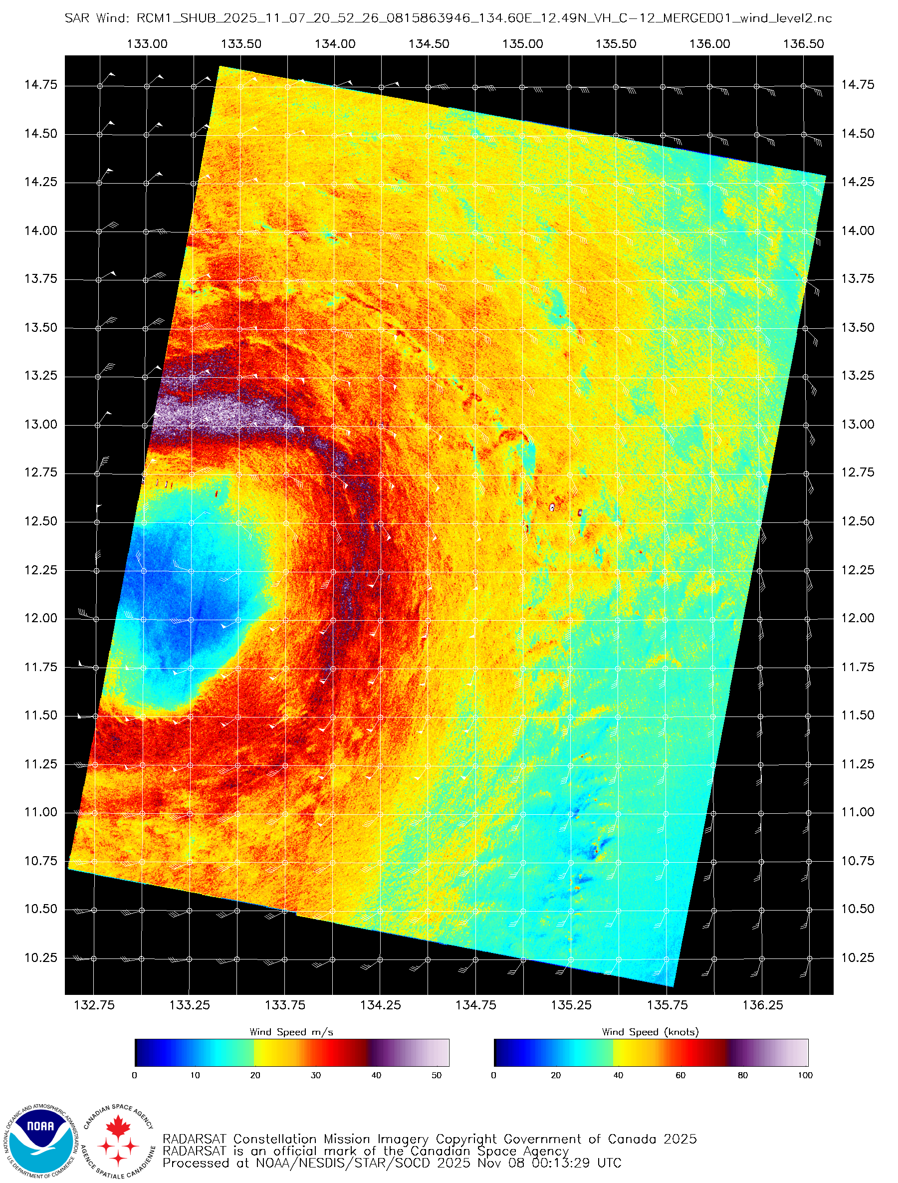
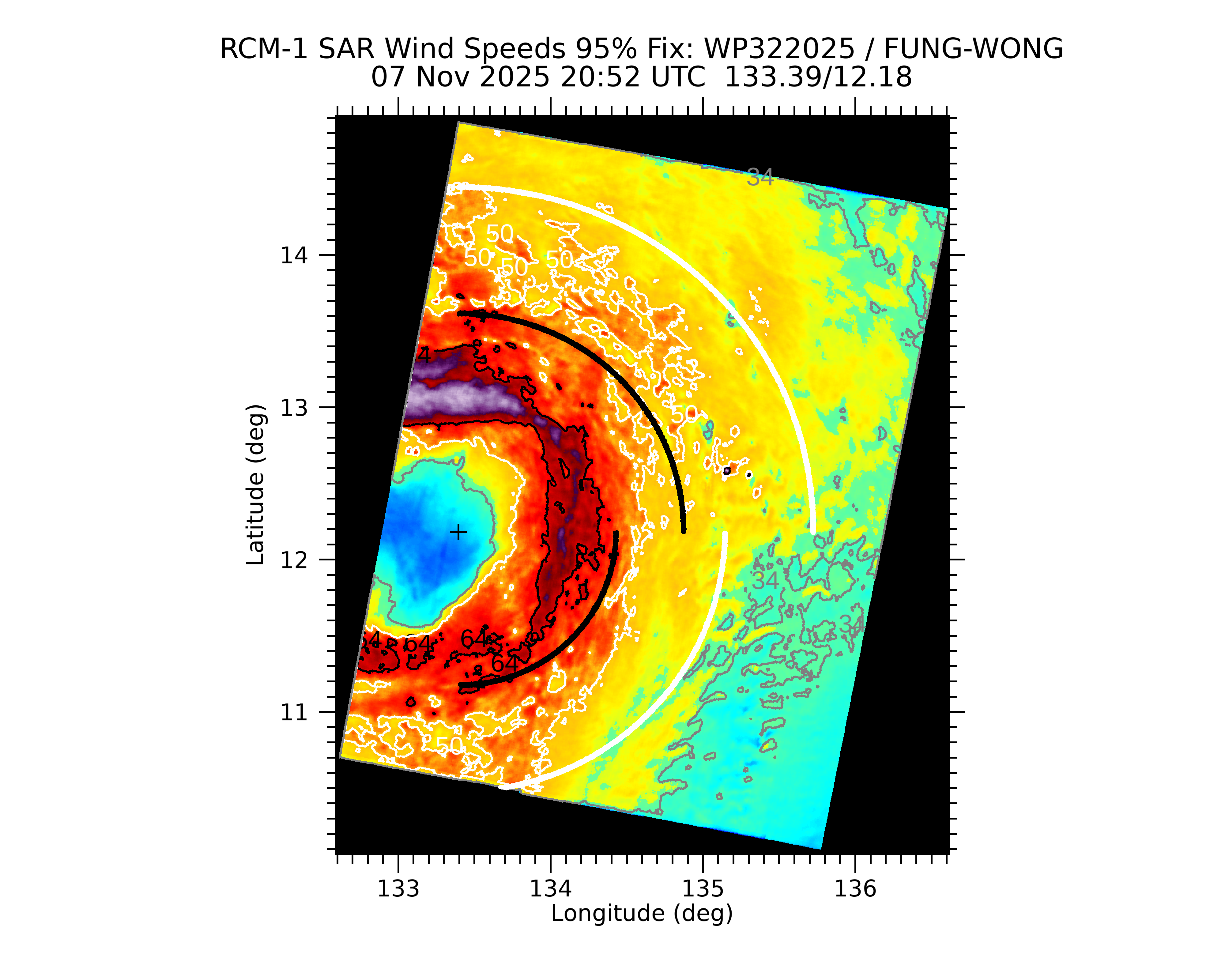
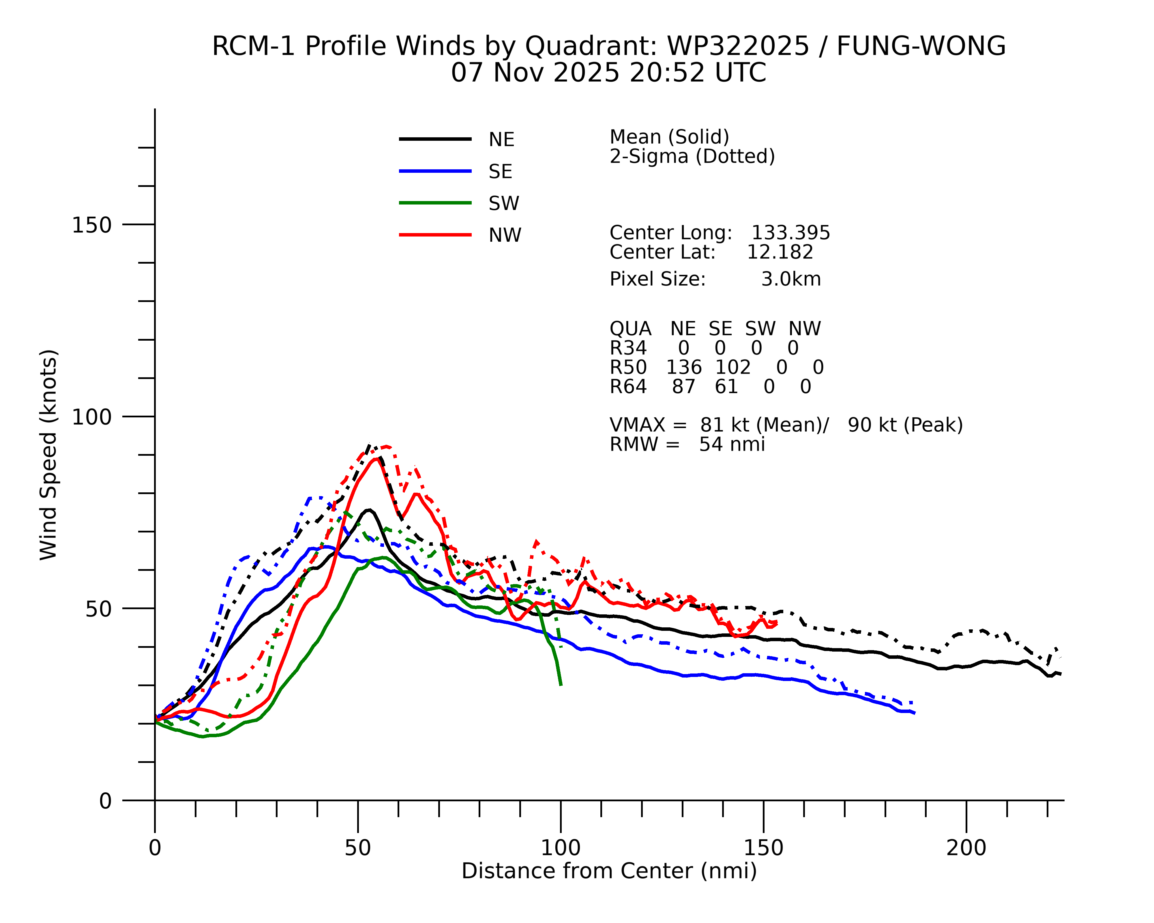
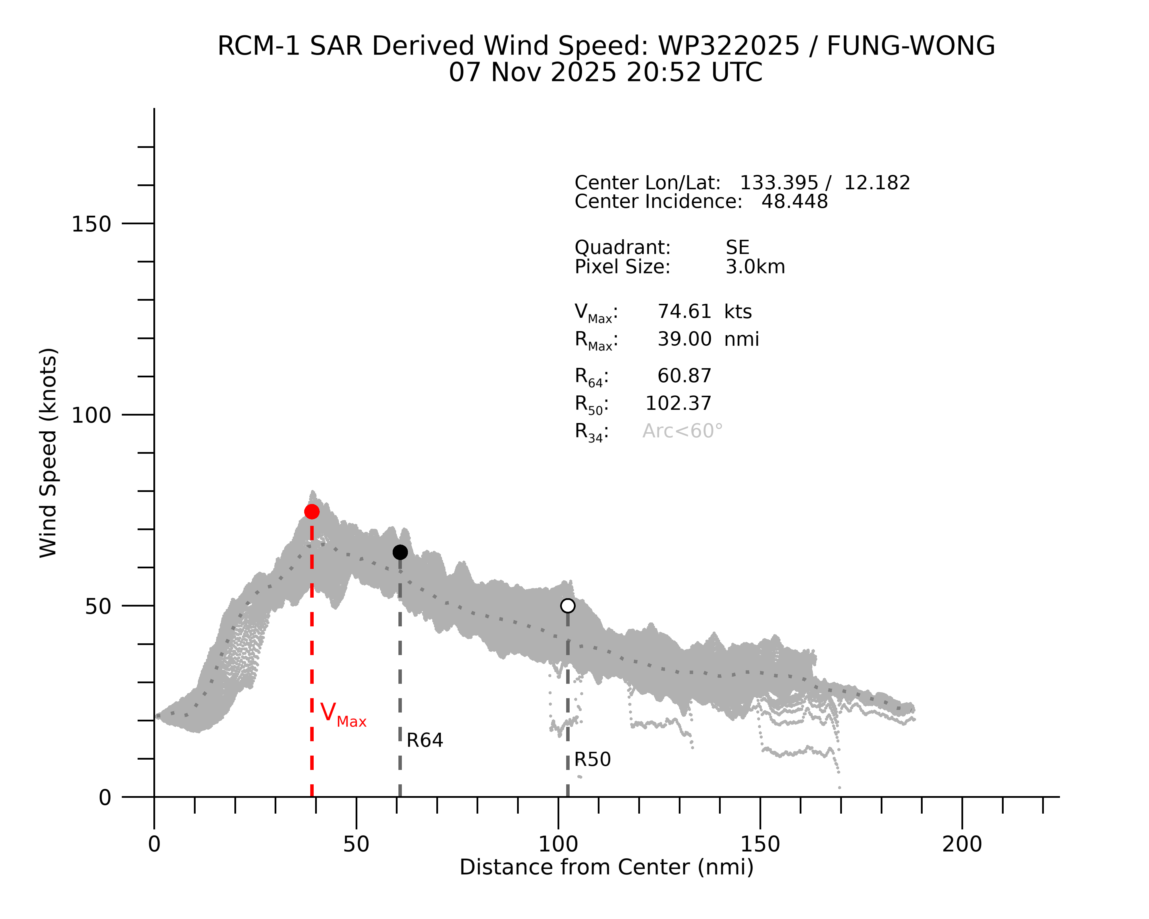
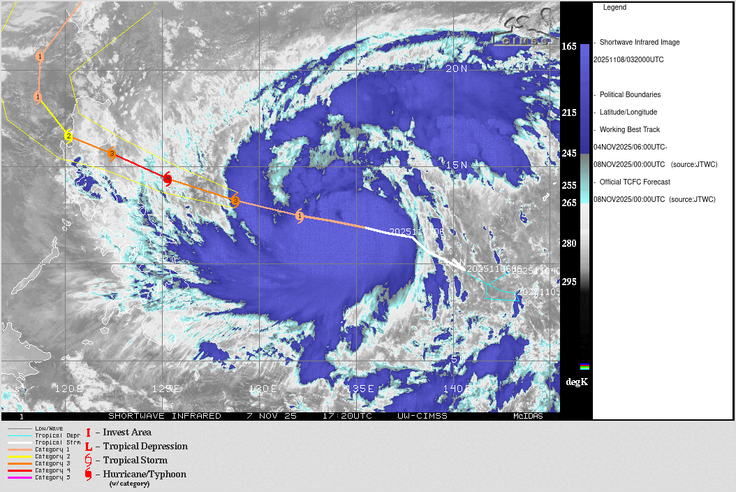
Fung-wong forming a giant eye is a mix of good and bad news. The best news is obviously lowered chances of ERI. That size of an eye would require lots of energy to contract and create a tighter pressure gradient. This storm only has around 30 hours to do so.

The bad news is that typhoons or hurricanes of this proportion tend to bring huge storm surge, and it will not only be in the area where the eye makes landfall (see Nesat 2011 in the Manila Bay area).

Also, very widespread wind and water damage can be expected, even hundreds of miles away from the center.
4 likes   
Personal Forecast Disclaimer:
The posts in this forum are NOT official forecast and should not be used as such. They are just the opinion of the poster and may or may not be backed by sound meteorological data. They are NOT endorsed by any professional institution or storm2k.org. For official information, please refer to the NHC and NWS products.

User avatar
mrbagyo
Category 5
Category 5
Posts: 3953
Age: 33
Joined: Thu Apr 12, 2012 9:18 am
Location: 14.13N 120.98E
Contact:

Re: WPAC: FUNG-WONG - Typhoon - Discussion

#158 Postby mrbagyo » Fri Nov 07, 2025 10:21 pm

18Z Euro is showing a possible direct pass over the Capital of Aurora Province.
0 likes   
The posts in this forum are NOT official forecast and should not be used as such. They are just the opinion of the poster and may or may not be backed by sound meteorological data. They are NOT endorsed by any professional institution or storm2k.org. For official information, please refer to RSMC, NHC and NWS products.

User avatar
cycloneye
Admin
Admin
Posts: 148441
Age: 69
Joined: Thu Oct 10, 2002 10:54 am
Location: San Juan, Puerto Rico

Re: WPAC: FUNG-WONG - Typhoon - Discussion

#159 Postby cycloneye » Fri Nov 07, 2025 10:28 pm

Is moving more west than westnorthwest. That is 270-275 west.

Image
2 likes   
Visit the Caribbean-Central America Weather Thread where you can find at first post web cams,radars
and observations from Caribbean basin members Click Here

User avatar
mrbagyo
Category 5
Category 5
Posts: 3953
Age: 33
Joined: Thu Apr 12, 2012 9:18 am
Location: 14.13N 120.98E
Contact:

Re: WPAC: FUNG-WONG - Typhoon - Discussion

#160 Postby mrbagyo » Fri Nov 07, 2025 11:27 pm

Image
0 likes   
The posts in this forum are NOT official forecast and should not be used as such. They are just the opinion of the poster and may or may not be backed by sound meteorological data. They are NOT endorsed by any professional institution or storm2k.org. For official information, please refer to RSMC, NHC and NWS products.


Return to “Active Storms - WestPAC/Asia”

Who is online

Users browsing this forum: No registered users and 8 guests