https://x.com/BOM_au/status/1991225912185020903
SIO: FINA - Post-Tropical
Moderator: S2k Moderators
-
cycloneye

- Admin

- Posts: 149275
- Age: 69
- Joined: Thu Oct 10, 2002 10:54 am
- Location: San Juan, Puerto Rico
Re: SIO: FINA - Tropical Cyclone
1 likes
Visit the Caribbean-Central America Weather Thread where you can find at first post web cams,radars
and observations from Caribbean basin members Click Here
and observations from Caribbean basin members Click Here


Re: SIO: FINA - Tropical Cyclone
Wow! The 21z forecast from JTWC now calls for continued intensification to an 80 kt peak in 48 hours (with hurricane strength maintained through the end of the forecast period). This is a pretty substantial change from the 15z forecast, which only showed a 65 kt peak at 0z followed by gradual weakening.
1 likes
-
Hurricane2022

- Category 5

- Posts: 2016
- Joined: Tue Aug 23, 2022 11:38 pm
- Location: Araçatuba, Brazil
Re: SIO: FINA - Tropical Cyclone
https://x.com/DerekOrtt/status/1991278387453915309
https://x.com/Sausius_wx/status/1991299401307025437
https://x.com/Sausius_wx/status/1991299401307025437
0 likes
Sorry for the bad English sometimes...!
For reliable and detailed information for any meteorological phenomenon, please consult the National Hurricane Center, Joint Typhoon Warning Center , or your local Meteo Center.
--------
ECCE OMNIA NOVA FACIAM (Ap 21,5).
For reliable and detailed information for any meteorological phenomenon, please consult the National Hurricane Center, Joint Typhoon Warning Center , or your local Meteo Center.
--------
ECCE OMNIA NOVA FACIAM (Ap 21,5).
Re: SIO: FINA - Tropical Cyclone
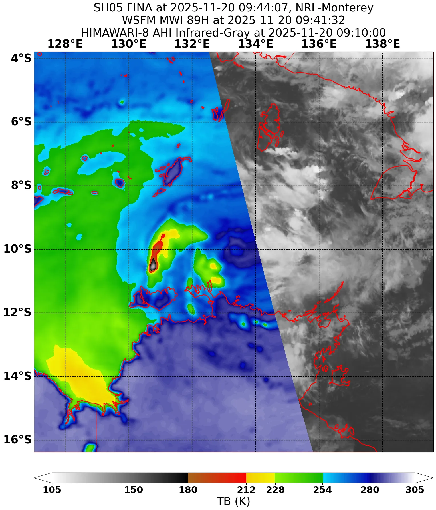
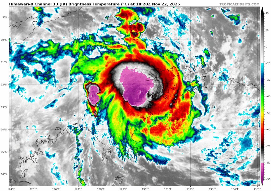
Yeah, Fina seems to have resumed intensification. The eye is evident on radar (after having become indistinct previously) and ADT #s are climbing back towards 4.0 (where subjective Dvorak estimates have been for almost 24 hours); the CDO also is no longer as irregular as it appeared early this afternoon. I think there's plenty of justification for 65 kt / 980 hPa for the 0z best track; it reflects the most recent satellite evidence, doesn't violate constraints, & is consistent with a radar eye. (The eyewall may have been disrupted earlier but the radar imagery is more recent.
Edit [as of 0117z]
Edit [as of 0117z]
05S FINA 251120 0000 9.8S 133.2E SHEM 65 980
1 likes
-
mrbagyo

- Category 5
- Posts: 3963
- Age: 33
- Joined: Thu Apr 12, 2012 9:18 am
- Location: 14.13N 120.98E
- Contact:
Re: SIO: FINA - Tropical Cyclone
microwave from more than 6 hrs ago
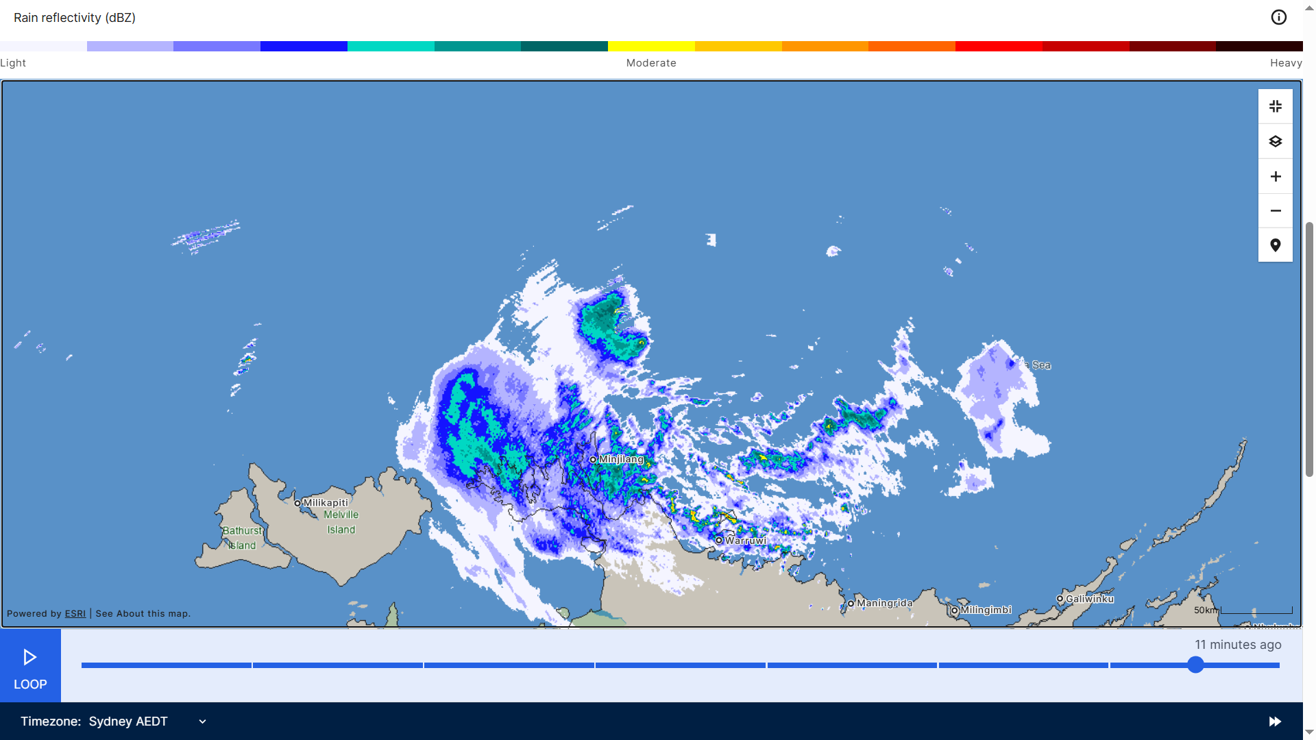
quite an amazing convective detonation an hour after that microwave - BOOM!


quite an amazing convective detonation an hour after that microwave - BOOM!
3 likes
The posts in this forum are NOT official forecast and should not be used as such. They are just the opinion of the poster and may or may not be backed by sound meteorological data. They are NOT endorsed by any professional institution or storm2k.org. For official information, please refer to RSMC, NHC and NWS products.
-
Hurricane2022
- Category 5
- Posts: 2016
- Joined: Tue Aug 23, 2022 11:38 pm
- Location: Araçatuba, Brazil
Re: SIO: FINA - Tropical Cyclone
She's fighting.


0 likes
Sorry for the bad English sometimes...!
For reliable and detailed information for any meteorological phenomenon, please consult the National Hurricane Center, Joint Typhoon Warning Center , or your local Meteo Center.
--------
ECCE OMNIA NOVA FACIAM (Ap 21,5).
For reliable and detailed information for any meteorological phenomenon, please consult the National Hurricane Center, Joint Typhoon Warning Center , or your local Meteo Center.
--------
ECCE OMNIA NOVA FACIAM (Ap 21,5).
-
Hurricane2022
- Category 5
- Posts: 2016
- Joined: Tue Aug 23, 2022 11:38 pm
- Location: Araçatuba, Brazil
Re: SIO: FINA - Tropical Cyclone
Fina seems to have good outflow now but the wind shear still appears to be visibly high at the lower levels

0 likes
Sorry for the bad English sometimes...!
For reliable and detailed information for any meteorological phenomenon, please consult the National Hurricane Center, Joint Typhoon Warning Center , or your local Meteo Center.
--------
ECCE OMNIA NOVA FACIAM (Ap 21,5).
For reliable and detailed information for any meteorological phenomenon, please consult the National Hurricane Center, Joint Typhoon Warning Center , or your local Meteo Center.
--------
ECCE OMNIA NOVA FACIAM (Ap 21,5).
-
cycloneye
- Admin
- Posts: 149275
- Age: 69
- Joined: Thu Oct 10, 2002 10:54 am
- Location: San Juan, Puerto Rico
Re: SIO: FINA - Tropical Cyclone
Time/date from issue (UTC) Latitude and longitude Accurate within Max wind Pressure
+6 hours+6 hr 1200 21 Nov 11.0° SouthS, 132.2° EastE 30 nautical miles 50 kilometres30nm (50km) 50 knots 95 kilometres per hour50 knots (95km/h) 987 hectopascals987 hPa
+12 hours+12 hr 1800 21 Nov 11.3° SouthS, 131.8° EastE 35 nautical miles 65 kilometres35nm (65km) 55 knots 100 kilometres per hour55 knots (100km/h) 983 hectopascals983 hPa
+18 hours+18 hr 0000 22 Nov 11.6° SouthS, 131.4° EastE 45 nautical miles 80 kilometres45nm (80km) 60 knots 110 kilometres per hour60 knots (110km/h) 980 hectopascals980 hPa
+24 hours+24 hr 0600 22 Nov 11.9° SouthS, 131.0° EastE 50 nautical miles 95 kilometres50nm (95km) 60 knots 110 kilometres per hour60 knots (110km/h) 980 hectopascals980 hPa
+36 hours+36 hr 1800 22 Nov 12.2° SouthS, 130.1° EastE 65 nautical miles 120 kilometres65nm (120km) 60 knots 110 kilometres per hour60 knots (110km/h) 980 hectopascals980 hPa
+48 hours+48 hr 0600 23 Nov 12.6° SouthS, 129.4° EastE 65 nautical miles 125 kilometres65nm (125km) 60 knots 110 kilometres per hour60 knots (110km/h) 980 hectopascals980 hPa
+60 hours+60 hr 1800 23 Nov 12.9° SouthS, 128.7° EastE 80 nautical miles 150 kilometres80nm (150km) 65 knots 120 kilometres per hour65 knots (120km/h) 975 hectopascals975 hPa
+72 hours+72 hr 0600 24 Nov 13.0° SouthS, 127.9° EastE 95 nautical miles 175 kilometres95nm (175km) 70 knots 130 kilometres per hour70 knots (130km/h) 972 hectopascals972 hPa
+96 hours+96 hr 0600 25 Nov 13.2° SouthS, 126.8° EastE 135 nautical miles 250 kilometres135nm (250km) 50 knots 95 kilometres per hour50 knots (95km/h) 986 hectopascals986 hPa
+120 hours+120 hr 0600 26 Nov 13.8° SouthS, 126.1° EastE 180 nautical miles 335 kilometres180nm (335km) 35 knots 65 kilometres per hour35 knots (65km/h) 995 hectopascals995 hPa
Tropical Cyclone Fina is located to the north of the Top End coast and moving slowly towards the southwest. Position is good based on radar tracking. Recent visible imagery and radar imagery show improved banding and tighter low level centre and a more vertical structure. Dvorak is based on DT, with a curved band pattern type of 0.7 resulting in a DT of 3.5. A D- trend gives a MET of 3.5, PAT 3.5, and FT/CI of 3.5. Intensity is 50 knots, based on subjective Dvorak and objective guidance. Objective guidance (1-min winds): ADT 61 knots, AiDT 67 knots, DPRINT 47 knots, DMINT 54knots (0459UTC), SATCON 56knots 0600UTC). ADT and AiDT have consistently had estimates significantly higher than other aids. In the case of ADT, a PMW adjust appears to have led to the much higher values. Good agreement with NWP model track for Fina to move generally in a southwest direction towards the north coastline of the NT tonight and then track through the Van Diemen Gulf and north of Darwin, on Saturday. In the longer term, models continue a west southwest track taking Fina back over water in the Timor Sea and towards the northern parts of Western Australia early next week. Vertical shear is weakening and likely remain low into the weekend. This, coupled with other supporting factors including warm SST, outflow to the southwest and sufficient low-level moisture, mean that Fina is expected to strengthen further during Friday, potentially quite quickly overnight tonight. Fina is forecast to reach an intensity of 60 knots during Saturday morning before interaction with land inhibits further development. Once over the open water of the southern Timor Sea, Fina is expected to strengthen further to a category 3 Severe Tropical Cyclone for a period on Monday. Drier air and increasing vertical shear from Monday onwards. are expected to weaken the system in the long term.
0 likes
Visit the Caribbean-Central America Weather Thread where you can find at first post web cams,radars
and observations from Caribbean basin members Click Here
and observations from Caribbean basin members Click Here
-
cycloneye
- Admin
- Posts: 149275
- Age: 69
- Joined: Thu Oct 10, 2002 10:54 am
- Location: San Juan, Puerto Rico
Re: SIO: FINA - Tropical Cyclone
0 likes
Visit the Caribbean-Central America Weather Thread where you can find at first post web cams,radars
and observations from Caribbean basin members Click Here
and observations from Caribbean basin members Click Here
-
mrbagyo
- Category 5
- Posts: 3963
- Age: 33
- Joined: Thu Apr 12, 2012 9:18 am
- Location: 14.13N 120.98E
- Contact:
Re: SIO: FINA - Tropical Cyclone

2 likes
The posts in this forum are NOT official forecast and should not be used as such. They are just the opinion of the poster and may or may not be backed by sound meteorological data. They are NOT endorsed by any professional institution or storm2k.org. For official information, please refer to RSMC, NHC and NWS products.
-
cycloneye
- Admin
- Posts: 149275
- Age: 69
- Joined: Thu Oct 10, 2002 10:54 am
- Location: San Juan, Puerto Rico
Re: SIO: FINA - Tropical Cyclone
0 likes
Visit the Caribbean-Central America Weather Thread where you can find at first post web cams,radars
and observations from Caribbean basin members Click Here
and observations from Caribbean basin members Click Here
Re: SIO: FINA - Tropical Cyclone
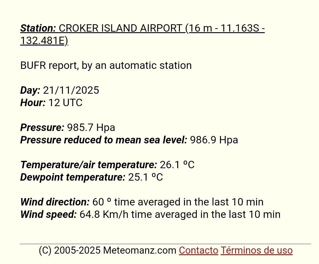
MW eye seems to be getting more defined, not less. Subjective DT remains at 4.0 (and probably will continue to, until/unless we see an eye pop out on VIS or EIR). The JTWC's 18z BT point is 70 kt / 979 hPa (up from 65 kt / 980 hPa at 12z), with 979 hPa being exactly what CKZ yields for Vmax 70 kts, 5 kt forward motion, and P(env) = 1006. The JTWC's forecast of 75 kts around the time of Fina's closest approach to Darwin (12z Saturday) and 85 kts at peak (12z Sunday) seems very reasonable, though probably the storm's proximity to land adds a lot of uncertainty.
1 likes
-
Hurricane2022
- Category 5
- Posts: 2016
- Joined: Tue Aug 23, 2022 11:38 pm
- Location: Araçatuba, Brazil
Re: SIO: FINA - Tropical Cyclone
1 likes
Sorry for the bad English sometimes...!
For reliable and detailed information for any meteorological phenomenon, please consult the National Hurricane Center, Joint Typhoon Warning Center , or your local Meteo Center.
--------
ECCE OMNIA NOVA FACIAM (Ap 21,5).
For reliable and detailed information for any meteorological phenomenon, please consult the National Hurricane Center, Joint Typhoon Warning Center , or your local Meteo Center.
--------
ECCE OMNIA NOVA FACIAM (Ap 21,5).
-
mrbagyo
- Category 5
- Posts: 3963
- Age: 33
- Joined: Thu Apr 12, 2012 9:18 am
- Location: 14.13N 120.98E
- Contact:
Re: SIO: FINA - Tropical Cyclone
2 likes
The posts in this forum are NOT official forecast and should not be used as such. They are just the opinion of the poster and may or may not be backed by sound meteorological data. They are NOT endorsed by any professional institution or storm2k.org. For official information, please refer to RSMC, NHC and NWS products.

Re: SIO: FINA - Tropical Cyclone
0 likes
TC naming lists: retirements and intensity
Most aggressive Advisory #1's in North Atlantic (cr. kevin for starting the list)
Most aggressive Advisory #1's in North Atlantic (cr. kevin for starting the list)
-
mrbagyo
- Category 5
- Posts: 3963
- Age: 33
- Joined: Thu Apr 12, 2012 9:18 am
- Location: 14.13N 120.98E
- Contact:
Re: SIO: FINA - Tropical Cyclone

Looks like Fina has a shot at becoming a major
2 likes
The posts in this forum are NOT official forecast and should not be used as such. They are just the opinion of the poster and may or may not be backed by sound meteorological data. They are NOT endorsed by any professional institution or storm2k.org. For official information, please refer to RSMC, NHC and NWS products.
-
Hurricane2022
- Category 5
- Posts: 2016
- Joined: Tue Aug 23, 2022 11:38 pm
- Location: Araçatuba, Brazil
Re: SIO: FINA - Tropical Cyclone
0 likes
Sorry for the bad English sometimes...!
For reliable and detailed information for any meteorological phenomenon, please consult the National Hurricane Center, Joint Typhoon Warning Center , or your local Meteo Center.
--------
ECCE OMNIA NOVA FACIAM (Ap 21,5).
For reliable and detailed information for any meteorological phenomenon, please consult the National Hurricane Center, Joint Typhoon Warning Center , or your local Meteo Center.
--------
ECCE OMNIA NOVA FACIAM (Ap 21,5).
-
cycloneye
- Admin
- Posts: 149275
- Age: 69
- Joined: Thu Oct 10, 2002 10:54 am
- Location: San Juan, Puerto Rico
Re: SIO: FINA - Tropical Cyclone
Time/date from issue (UTC) Latitude and longitude Accurate within Max wind Pressure
+6 hours+6 hr 0600 23 Nov 12.9° SouthS, 129.4° EastE 25 nautical miles 45 kilometres25nm (45km) 95 knots 175 kilometres per hour95 knots (175km/h) 950 hectopascals950 hPa
+12 hours+12 hr 1200 23 Nov 13.2° SouthS, 129.1° EastE 30 nautical miles 60 kilometres30nm (60km) 100 knots 185 kilometres per hour100 knots (185km/h) 944 hectopascals944 hPa
+18 hours+18 hr 1800 23 Nov 13.4° SouthS, 128.9° EastE 40 nautical miles 80 kilometres40nm (80km) 95 knots 175 kilometres per hour95 knots (175km/h) 950 hectopascals950 hPa
+24 hours+24 hr 0000 24 Nov 13.6° SouthS, 128.5° EastE 50 nautical miles 90 kilometres50nm (90km) 85 knots 155 kilometres per hour85 knots (155km/h) 959 hectopascals959 hPa
+36 hours+36 hr 1200 24 Nov 13.7° SouthS, 127.8° EastE 60 nautical miles 110 kilometres60nm (110km) 60 knots 110 kilometres per hour60 knots (110km/h) 980 hectopascals980 hPa
+48 hours+48 hr 0000 25 Nov 13.5° SouthS, 127.1° EastE 70 nautical miles 135 kilometres70nm (135km) 40 knots 75 kilometres per hour40 knots (75km/h) 994 hectopascals994 hPa
+60 hours+60 hr 1200 25 Nov 13.6° SouthS, 126.4° EastE 95 nautical miles 175 kilometres95nm (175km) 30 knots 55 kilometres per hour30 knots (55km/h) 999 hectopascals999 hPa
+72 hours+72 hr 0000 26 Nov 13.7° SouthS, 126.0° EastE 110 nautical miles 200 kilometres110nm (200km) 30 knots 55 kilometres per hour30 knots (55km/h) 999 hectopascals999 hPa
+96 hours+96 hr 0000 27 Nov 14.4° SouthS, 125.4° EastE 155 nautical miles 285 kilometres155nm (285km) 25 knots 45 kilometres per hour25 knots (45km/h) 1001 hectopascals1001 hPa
Remarks
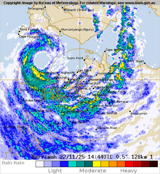
Severe Tropical Cyclone Fina, a very compact category 3 system continues to move away from land and is expected to intensify today. Centre fix is good, based primarily on Darwin (Berrimah) radar. The eye was quite ragged and undiscernible at times between 18 and 23 UTC, however over the last hour, both radar and satellite imagery show an improved eye structure. Intensity is 80 knots based on Dvorak and consistent with most objective aids. Dvorak: 3-hour average DT is 4.5 to 5.0 using an eye pattern (2300UTC image showed LG grey shade surround with LG eye and W surround, resulting in a DT of 4.0). MET is 4.5 with a D- trend, PAT agrees at 5.0. FT/CI 5.0/5.0 based on PAT. Latest available CIMSS objective guidance (1-min winds) have all intensified and become closer to be in line with subjective analysis. Accessed at 0000 UTC: ADT 90 kn (CI=5.0), AiDT 86 kn, DPRINT 77 kn, SATCON 79 kn. There are no surface observations near the core of Fina, but 30 kn winds were being at Charles Point until 2300UTC. Fina appears to be recovering from its earlier weakening and showing further signs of intensification as it moves further away from land. Guidance is generally consistent in Fina continuing on a southwest track during Sunday moving towards the northern part of the Joseph Bonaparte Gulf. Fina should take a more westerly track over water in the southern Timor Sea on Monday and towards the northern parts of Western Australia. There is a chance the system continues its southwest track longer on Monday towards the Kimberley coast before weakening. Latest available CIMSS shear analysis was for 18UTC when it was analysed northerly at less than 10 knots. Models indicate shear is likely to stay low during Sunday. This, coupled with other supporting factors including warm SST, outflow to the southwest and sufficient low-level moisture, means that Fina is expected to strengthen further, and is forecast to reach 100 kn (category 4) intensity on Sunday, when it will be in the southern Timor Sea. From Monday conditions become unfavourable with increased shear and dry air expected to weaken the system. Fina may impact the north Kimberley coast of Western Australia as a tropical cyclone, or weaken while still over water.
+6 hours+6 hr 0600 23 Nov 12.9° SouthS, 129.4° EastE 25 nautical miles 45 kilometres25nm (45km) 95 knots 175 kilometres per hour95 knots (175km/h) 950 hectopascals950 hPa
+12 hours+12 hr 1200 23 Nov 13.2° SouthS, 129.1° EastE 30 nautical miles 60 kilometres30nm (60km) 100 knots 185 kilometres per hour100 knots (185km/h) 944 hectopascals944 hPa
+18 hours+18 hr 1800 23 Nov 13.4° SouthS, 128.9° EastE 40 nautical miles 80 kilometres40nm (80km) 95 knots 175 kilometres per hour95 knots (175km/h) 950 hectopascals950 hPa
+24 hours+24 hr 0000 24 Nov 13.6° SouthS, 128.5° EastE 50 nautical miles 90 kilometres50nm (90km) 85 knots 155 kilometres per hour85 knots (155km/h) 959 hectopascals959 hPa
+36 hours+36 hr 1200 24 Nov 13.7° SouthS, 127.8° EastE 60 nautical miles 110 kilometres60nm (110km) 60 knots 110 kilometres per hour60 knots (110km/h) 980 hectopascals980 hPa
+48 hours+48 hr 0000 25 Nov 13.5° SouthS, 127.1° EastE 70 nautical miles 135 kilometres70nm (135km) 40 knots 75 kilometres per hour40 knots (75km/h) 994 hectopascals994 hPa
+60 hours+60 hr 1200 25 Nov 13.6° SouthS, 126.4° EastE 95 nautical miles 175 kilometres95nm (175km) 30 knots 55 kilometres per hour30 knots (55km/h) 999 hectopascals999 hPa
+72 hours+72 hr 0000 26 Nov 13.7° SouthS, 126.0° EastE 110 nautical miles 200 kilometres110nm (200km) 30 knots 55 kilometres per hour30 knots (55km/h) 999 hectopascals999 hPa
+96 hours+96 hr 0000 27 Nov 14.4° SouthS, 125.4° EastE 155 nautical miles 285 kilometres155nm (285km) 25 knots 45 kilometres per hour25 knots (45km/h) 1001 hectopascals1001 hPa
Remarks
Severe Tropical Cyclone Fina, a very compact category 3 system continues to move away from land and is expected to intensify today. Centre fix is good, based primarily on Darwin (Berrimah) radar. The eye was quite ragged and undiscernible at times between 18 and 23 UTC, however over the last hour, both radar and satellite imagery show an improved eye structure. Intensity is 80 knots based on Dvorak and consistent with most objective aids. Dvorak: 3-hour average DT is 4.5 to 5.0 using an eye pattern (2300UTC image showed LG grey shade surround with LG eye and W surround, resulting in a DT of 4.0). MET is 4.5 with a D- trend, PAT agrees at 5.0. FT/CI 5.0/5.0 based on PAT. Latest available CIMSS objective guidance (1-min winds) have all intensified and become closer to be in line with subjective analysis. Accessed at 0000 UTC: ADT 90 kn (CI=5.0), AiDT 86 kn, DPRINT 77 kn, SATCON 79 kn. There are no surface observations near the core of Fina, but 30 kn winds were being at Charles Point until 2300UTC. Fina appears to be recovering from its earlier weakening and showing further signs of intensification as it moves further away from land. Guidance is generally consistent in Fina continuing on a southwest track during Sunday moving towards the northern part of the Joseph Bonaparte Gulf. Fina should take a more westerly track over water in the southern Timor Sea on Monday and towards the northern parts of Western Australia. There is a chance the system continues its southwest track longer on Monday towards the Kimberley coast before weakening. Latest available CIMSS shear analysis was for 18UTC when it was analysed northerly at less than 10 knots. Models indicate shear is likely to stay low during Sunday. This, coupled with other supporting factors including warm SST, outflow to the southwest and sufficient low-level moisture, means that Fina is expected to strengthen further, and is forecast to reach 100 kn (category 4) intensity on Sunday, when it will be in the southern Timor Sea. From Monday conditions become unfavourable with increased shear and dry air expected to weaken the system. Fina may impact the north Kimberley coast of Western Australia as a tropical cyclone, or weaken while still over water.
0 likes
Visit the Caribbean-Central America Weather Thread where you can find at first post web cams,radars
and observations from Caribbean basin members Click Here
and observations from Caribbean basin members Click Here
Re: SIO: FINA - Severe Tropical Cyclone
I think it's entirely possible that Fina's peak this morning was closer to 105 kt / 950 hPa; it looked awfully similar to TY Danas (from much earlier this year) for a minute there, which was operationally assessed at 110 kt. I overslept and didn't get a chance to comb through all the satellite data I missed but there were a few frames where the eye shade appeared to be B rather than W, which would yield a DT6.0 (before applying constraints) if I'm not mistaken. Either way, Fina overperformed expectations by a fair margin, and it's fortunate that the human impacts were not more severe. Read in the news this morning that she was the strongest cyclone since Tracy '74 to approach Darwin.
2 likes
Re: SIO: FINA - Severe Tropical Cyclone

1 likes
TC naming lists: retirements and intensity
Most aggressive Advisory #1's in North Atlantic (cr. kevin for starting the list)
Most aggressive Advisory #1's in North Atlantic (cr. kevin for starting the list)
Who is online
Users browsing this forum: No registered users and 24 guests