SIO: FINA - Severe Tropical Cyclone


Moderators: hurricanetrack, S2k Moderators

Forum rules

The posts in this forum are NOT official forecast and should not be used as such. They are just the opinion of the poster and may or may not be backed by sound meteorological data. They are NOT endorsed by any professional institution or STORM2K.

Help Support Storm2K
Message
Author
User avatar
sasha_B
Category 1
Category 1
Posts: 279
Age: 24
Joined: Sun Jun 30, 2024 4:32 pm
Location: Charleston, SC

Re: SIO: FINA - Severe Tropical Cyclone

#41 Postby sasha_B » Sun Nov 23, 2025 12:26 pm


Looking real good even now....eye is almost starting to pop out again.

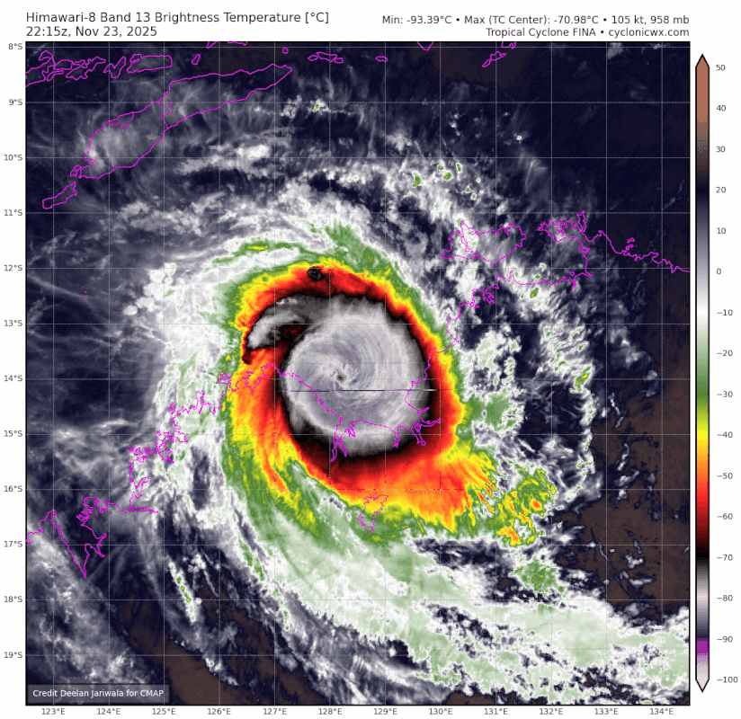
Edit: W eye embedded in CMG @ 1729z yields DT=(6.5-1.0)=5.5, which is equal to the JTWC's CI# on the last satellite bulletin. In the absence of a more recent MW pass to indicate that the eyewall has deteriorated, Fina is arguably still around MH-equivalent strength. Using the position/forward motion/wind radii/env. pressure from the last advisory, CKZ gives us a P(c) range of 953~959 hPa for a Vmax (1-min. sustained) between 95 (JTWC's 12z intensity estimate) and 102 kt (CI 5.5). Weakening is forecast but it doesn't seem to be progressing all that quickly yet, so holding the intensity at 95 / 960 on the next advisory would be justified even if the professionals arrive at FT=5.0 again.
1 likes   

User avatar
Hurricane2022
Category 5
Category 5
Posts: 1947
Joined: Tue Aug 23, 2022 11:38 pm
Location: Araçatuba, Brazil

Re: SIO: FINA - Severe Tropical Cyclone

#42 Postby Hurricane2022 » Sun Nov 23, 2025 1:10 pm

:froze:
Image
2 likes   
Sorry for the bad English sometimes...!
For reliable and detailed information for any meteorological phenomenon, please consult the National Hurricane Center, Joint Typhoon Warning Center , or your local Meteo Center.

--------

ECCE OMNIA NOVA FACIAM (Ap 21,5).

User avatar
Hurricane2022
Category 5
Category 5
Posts: 1947
Joined: Tue Aug 23, 2022 11:38 pm
Location: Araçatuba, Brazil

Re: SIO: FINA - Severe Tropical Cyclone

#43 Postby Hurricane2022 » Sun Nov 23, 2025 1:15 pm

2 likes   
Sorry for the bad English sometimes...!
For reliable and detailed information for any meteorological phenomenon, please consult the National Hurricane Center, Joint Typhoon Warning Center , or your local Meteo Center.

--------

ECCE OMNIA NOVA FACIAM (Ap 21,5).

User avatar
sasha_B
Category 1
Category 1
Posts: 279
Age: 24
Joined: Sun Jun 30, 2024 4:32 pm
Location: Charleston, SC

Re: SIO: FINA - Severe Tropical Cyclone

#44 Postby sasha_B » Sun Nov 23, 2025 3:28 pm

05S FINA 251123 1800 13.9S 128.5E SHEM 105 958


105 kt / 958 hPa at 18z on the JTWC operational best track.

The pressure estimate is a little higher than I expected; often a 10 kt increase in wind speed corresponds to more than a 2 hPa drop in pressure. CKZ for a cyclone with Vmax=105 kt at 13.9S with 34-kt winds extending to an average radius of 60 nm, 6 kt forward motion, and 1004 hPa MSLP at the outermost closed isobar, gives central pressure = (approx.) 950 hPa. (You get closer to 958 if you assume that forward motion has accelerated significantly and that Vmax was rounded up to a 5-kt increment, and use ADT's higher environmental pressure value.)

In any case, Fina continues to exceed expectations.
3 likes   

User avatar
cycloneye
Admin
Admin
Posts: 148503
Age: 69
Joined: Thu Oct 10, 2002 10:54 am
Location: San Juan, Puerto Rico

Re: SIO: FINA - Severe Tropical Cyclone

#45 Postby cycloneye » Sun Nov 23, 2025 4:14 pm

Remarks

Severe Tropical Cyclone Fina is a category 4 system and moving towards the northern WA coastline. Centre fix is good, based on recent scatterometry satellite and radar data with Fina displaying a well-defined circular eye. Intensity is 100 knots based primarily on subjective Dvorak, remaining resonably consistent with most objective aids and earlier SAR imagery. Dvorak: 3-hour average DT is 5.5 to 6.0 using an eye pattern, surrounding shade is CMG with W or B eye and CMG surround. Recently, have seen further warming and consolidation of the eye suggestive of further intensification, and a firmer DT estimate of 6.0. MET is 6.0 with a D trend, PAT agrees at 6.0. FT/CI 6.0/6.0 based on 3 hourly DT. Latest available CIMSS objective guidance (1-min winds) remain somewhat problematic. For 1730 UTC: ADT 84 kn (CI=4.8), AiDT 100 kn, DPRINT 106 kn, SATCON 91 kn. ADT seems to have a low bias with a struggle to recognise the eye pattern/scene, ADT raw T numbers when eye is recognised jump to 6.8 to 7.1. Overall low confidence in ADT and resultant SATCON. While fluctuating in its appearance in EIR imagery in the past six hours, presentation has been more consistent recently. Fina is maintaining its very compact circulation and solid category 4 strength. Guidance is generally consistent in Fina continuing on a southwest track across the Joseph Bonaparte Gulf in the short term taking it towards the northeast Kimberley coast of Western Australia and is likely to cross the Kimberley coast later Monday or early Tuesday as a tropical cyclone, however it is expected to be on a weakening trend as it approaches. Most models have called for increasing vertical shear over the cyclone during Monday, however latest available CIMSS shear analysis at 12UTC indicates northerly shear remaining less than 10 knots. This, coupled with other supporting factors including warm SST, outflow to the southwest and sufficient low-level moisture, means that Fina could maintain intensity for the next six hours or so before weakening begins later on Monday as conditions become less favourable. Although potentially delayed a little, most guidance still indicates an increase in vertical shear, and this in combination with dry mid to upper level air on the northern periphery and eventual land interaction, is expected to weaken the system relatively quickly. Though Fina is expected to weaken as it moves westwards during Monday, it is forecast to impact the northeast Kimberley coast of Western Australia as a severe tropical cyclone and then weaken quickly over land.
2 likes   
Visit the Caribbean-Central America Weather Thread where you can find at first post web cams,radars
and observations from Caribbean basin members Click Here

User avatar
sasha_B
Category 1
Category 1
Posts: 279
Age: 24
Joined: Sun Jun 30, 2024 4:32 pm
Location: Charleston, SC

Re: SIO: FINA - Severe Tropical Cyclone

#46 Postby sasha_B » Sun Nov 23, 2025 4:18 pm

ADT now identifies a "pinhole eye" scene type, so raw T# has spiked to 7.0, which is obviously unrealistic. That said, we do have a storm with a tiny RMW - the JTWC's 21z advisory has 64-kt winds extending only 10 nm from the center in each quadrant. That would suggest that the eye is rather small indeed.
(Adjusting the CKZ parameters for the updated & slightly smaller gale radii still only gives 950~952 hPa central pressure. As of right now, Fina's peak in terms of central pressure was ~12 hours ago, despite the current Vmax representing her overall peak winds.)
1 likes   

User avatar
Hurricane2022
Category 5
Category 5
Posts: 1947
Joined: Tue Aug 23, 2022 11:38 pm
Location: Araçatuba, Brazil

Re: SIO: FINA - Severe Tropical Cyclone

#47 Postby Hurricane2022 » Sun Nov 23, 2025 4:28 pm

Fina looks fine right now. Should intensify a little bit more before shear kicks in 6 - 12 hours.
Image
Image
1 likes   
Sorry for the bad English sometimes...!
For reliable and detailed information for any meteorological phenomenon, please consult the National Hurricane Center, Joint Typhoon Warning Center , or your local Meteo Center.

--------

ECCE OMNIA NOVA FACIAM (Ap 21,5).

User avatar
sasha_B
Category 1
Category 1
Posts: 279
Age: 24
Joined: Sun Jun 30, 2024 4:32 pm
Location: Charleston, SC

Re: SIO: FINA - Severe Tropical Cyclone

#48 Postby sasha_B » Sun Nov 23, 2025 4:36 pm

cycloneye wrote:
Remarks

Severe Tropical Cyclone Fina is a category 4 system and moving towards the northern WA coastline. Centre fix is good, based on recent scatterometry satellite and radar data with Fina displaying a well-defined circular eye. Intensity is 100 knots based primarily on subjective Dvorak, remaining resonably consistent with most objective aids and earlier SAR imagery. Dvorak: 3-hour average DT is 5.5 to 6.0 using an eye pattern, surrounding shade is CMG with W or B eye and CMG surround. Recently, have seen further warming and consolidation of the eye suggestive of further intensification, and a firmer DT estimate of 6.0. MET is 6.0 with a D trend, PAT agrees at 6.0. FT/CI 6.0/6.0 based on 3 hourly DT. Latest available CIMSS objective guidance (1-min winds) remain somewhat problematic. For 1730 UTC: ADT 84 kn (CI=4.8), AiDT 100 kn, DPRINT 106 kn, SATCON 91 kn. ADT seems to have a low bias with a struggle to recognise the eye pattern/scene, ADT raw T numbers when eye is recognised jump to 6.8 to 7.1. Overall low confidence in ADT and resultant SATCON. While fluctuating in its appearance in EIR imagery in the past six hours, presentation has been more consistent recently. Fina is maintaining its very compact circulation and solid category 4 strength. Guidance is generally consistent in Fina continuing on a southwest track across the Joseph Bonaparte Gulf in the short term taking it towards the northeast Kimberley coast of Western Australia and is likely to cross the Kimberley coast later Monday or early Tuesday as a tropical cyclone, however it is expected to be on a weakening trend as it approaches. Most models have called for increasing vertical shear over the cyclone during Monday, however latest available CIMSS shear analysis at 12UTC indicates northerly shear remaining less than 10 knots. This, coupled with other supporting factors including warm SST, outflow to the southwest and sufficient low-level moisture, means that Fina could maintain intensity for the next six hours or so before weakening begins later on Monday as conditions become less favourable. Although potentially delayed a little, most guidance still indicates an increase in vertical shear, and this in combination with dry mid to upper level air on the northern periphery and eventual land interaction, is expected to weaken the system relatively quickly. Though Fina is expected to weaken as it moves westwards during Monday, it is forecast to impact the northeast Kimberley coast of Western Australia as a severe tropical cyclone and then weaken quickly over land.


This seems closer to the mark than the JTWC's evaluation (which is based mostly on the same data but assumes an embedded center pattern at ~18z, capping the FT at 5.0, rather than an eye). It's not often that the Aus. BOM is more aggressive than they are when it comes to intensity estimates and in this case it seems called for. 100 kt (10-minute sustained) equates to about 114 kt (1-minute sustained) using the standard 0.88 conversion factor. Even erring on the low side (due to the fact that there's no longer any B in the eye), there's enough there to justify 110 kt winds (1-minute sustained) and therefor 945~947 hPa central pressure. (115 kts gives you 941, split the difference and you get the BOM's actual estimate of 943). This will be an interesting storm to see reanalysed.
1 likes   

User avatar
Hurricane2022
Category 5
Category 5
Posts: 1947
Joined: Tue Aug 23, 2022 11:38 pm
Location: Araçatuba, Brazil

Re: SIO: FINA - Severe Tropical Cyclone

#49 Postby Hurricane2022 » Sun Nov 23, 2025 4:57 pm

She is very small.
Image
1 likes   
Sorry for the bad English sometimes...!
For reliable and detailed information for any meteorological phenomenon, please consult the National Hurricane Center, Joint Typhoon Warning Center , or your local Meteo Center.

--------

ECCE OMNIA NOVA FACIAM (Ap 21,5).

User avatar
sasha_B
Category 1
Category 1
Posts: 279
Age: 24
Joined: Sun Jun 30, 2024 4:32 pm
Location: Charleston, SC

Re: SIO: FINA - Severe Tropical Cyclone

#50 Postby sasha_B » Sun Nov 23, 2025 7:13 pm

F. T5.5/5.5/D0.5/24HRS STT: S0.0/03HRS

G. IR/EIR/VIS/MSI

H. REMARKS: 11A/PBO RAGGED EYE/ANMTN. W EYE SURROUNDED BY CMG
YIELDS AN E# OF 6.5. SUBTRACTED 1.0 EYE ADJUSTMENT FOR CMG TO YIELD
A DT OF 5.5. MET AND PT AGREE. DBO DT. INTENSITY ESTIMATE MAY NOT
BE REPRESENTATIVE DUE TO PROXIMITY TO LAND.


JTWC has another FT 5.5 subjective fix for 0z. Satellite presentation is perhaps beginning to deteriorate but I'm expecting intensity to be maintained - possibly with a slight reduction in central pressure - for the operational BT point.
The anticipated point of landfall is not in an at all densely populated area, but this is IMO an interesting storm in terms of forecast error. Strengthening up to landfall was not anticipated; fairly rapid weakening was supposed to begin about 12 hours ago, in fact. Certain factors were clearly overlooked here.
2 likes   

User avatar
sasha_B
Category 1
Category 1
Posts: 279
Age: 24
Joined: Sun Jun 30, 2024 4:32 pm
Location: Charleston, SC

Re: SIO: FINA - Severe Tropical Cyclone

#51 Postby sasha_B » Sun Nov 23, 2025 7:54 pm

sasha_B wrote:
F. T5.5/5.5/D0.5/24HRS STT: S0.0/03HRS

G. IR/EIR/VIS/MSI

H. REMARKS: 11A/PBO RAGGED EYE/ANMTN. W EYE SURROUNDED BY CMG
YIELDS AN E# OF 6.5. SUBTRACTED 1.0 EYE ADJUSTMENT FOR CMG TO YIELD
A DT OF 5.5. MET AND PT AGREE. DBO DT. INTENSITY ESTIMATE MAY NOT
BE REPRESENTATIVE DUE TO PROXIMITY TO LAND.


JTWC has another FT 5.5 subjective fix for 0z. Satellite presentation is perhaps beginning to deteriorate but I'm expecting intensity to be maintained - possibly with a slight reduction in central pressure - for the operational BT point.
The anticipated point of landfall is not in an at all densely populated area, but this is IMO an interesting storm in terms of forecast error. Strengthening up to landfall was not anticipated; fairly rapid weakening was supposed to begin about 12 hours ago, in fact. Certain factors were clearly overlooked here.


I stand corrected: JTWC has 100 kt / 960 hPa for 0z. The discrepency in central pressure remains strange: CKZ yields 954 kt for 100 kt Vmax, given the parameters in place on the last advisory. Obviously in situ measurements trump any sort of extrapolation but given that previous advisories (until this morning) were within a few hPa of CKZ outputs I'm a little confused by this. As an amateur tracking this storm, I'd go with 105 kt / 952 hPa, higher than the JTWC's estimate but lower than the BOM's. The fact that there's a 14 kt / 17 hPa discrepency between the two agencies is in itself striking.
0 likes   

User avatar
cycloneye
Admin
Admin
Posts: 148503
Age: 69
Joined: Thu Oct 10, 2002 10:54 am
Location: San Juan, Puerto Rico

Re: SIO: FINA - Severe Tropical Cyclone

#52 Postby cycloneye » Sun Nov 23, 2025 10:22 pm

Severe Tropical Cyclone Fina 02U at 0000 UTC

13.9° SouthSLatitude
128.2° EastELongitude
10 nautical miles10 nm (20 kilometres20 km)Accurate within
West South WestWSW 241°Direction of movement
4 knots4 knots (8 kilometres per hour8 km/h)Movement speed
100 knots100 knots (185 kilometres per hour185 km/h)Maximum 10 minute wind speed
140 knots140 knots (260 kilometres per hour260 km/h)Maximum 3 second wind gust
944 hectopascals944 hPaCentral pressure
T5.5/6.0/D0.5/24HRS SST:W0.5/06HRSDvorak Intensity Code
1004 hectopascals1004 hPaOutermost isobar
100 nautical miles100 nm (185 kilometres185 km)Radius of outermost closed isobar
20 nautical miles20 nm (35 kilometres35 km)64 knot wind radius
5 nautical miles5 nm (10 kilometres10 km)Maximum wind radius
Wind radius
Wind radius North East quadrantNE quadrant South East quadrantSE quadrant South West quadrantSW quadrant North West quadrantNW quadrant
34 knots 35 nautical miles 65 kilometres35nm (65km) 45 nautical miles 85 kilometres45nm (85km) 55 nautical miles 100 kilometres55nm (100km) 50 nautical miles 95 kilometres50nm (95km)
48 knots 25 nautical miles 45 kilometres25nm (45km) 40 nautical miles 75 kilometres40nm (75km) 40 nautical miles 75 kilometres40nm (75km) 30 nautical miles 55 kilometres30nm (55km)
Forecast
Time/date from issue Coordinated Universal TimeTime/date from issue (UTC) Latitude and longitude Accurate within Max wind Pressure
+6 hours+6 hr 0600 24 Nov 14.0° SouthS, 127.9° EastE 25 nautical miles 40 kilometres25nm (40km) 90 knots 165 kilometres per hour90 knots (165km/h) 953 hectopascals953 hPa
+12 hours+12 hr 1200 24 Nov 14.1° SouthS, 127.5° EastE 30 nautical miles 55 kilometres30nm (55km) 70 knots 130 kilometres per hour70 knots (130km/h) 971 hectopascals971 hPa
+18 hours+18 hr 1800 24 Nov 14.1° SouthS, 127.3° EastE 40 nautical miles 70 kilometres40nm (70km) 50 knots 95 kilometres per hour50 knots (95km/h) 986 hectopascals986 hPa
+24 hours+24 hr 0000 25 Nov 14.1° SouthS, 127.0° EastE 45 nautical miles 80 kilometres45nm (80km) 30 knots 55 kilometres per hour30 knots (55km/h) 998 hectopascals998 hPa
+36 hours+36 hr 1200 25 Nov 14.3° SouthS, 126.7° EastE 60 nautical miles 110 kilometres60nm (110km) 25 knots 45 kilometres per hour25 knots (45km/h) 1000 hectopascals1000 hPa
+48 hours+48 hr 0000 26 Nov 14.5° SouthS, 126.4° EastE 75 nautical miles 140 kilometres75nm (140km) 25 knots 45 kilometres per hour25 knots (45km/h) 1000 hectopascals1000 hPa
+60 hours+60 hr 1200 26 Nov 15.2° SouthS, 126.5° EastE 115 nautical miles 210 kilometres115nm (210km) 20 knots 35 kilometres per hour20 knots (35km/h) 1003 hectopascals1003 hPa
+72 hours+72 hr 0000 27 Nov not applicablen/a not applicablen/a not applicablen/a not applicablen/a
+96 hours+96 hr 0000 28 Nov not applicablen/a not applicablen/a not applicablen/a not applicablen/a
+120 hours+120 hr 0000 29 Nov not applicablen/a not applicablen/a not applicablen/a not applicablen/a

Remarks

Severe Tropical Cyclone Fina is a category 4 system and moving west towards the northeast Kimberley coast. Centre fix is good, based on recent radar imagery with Fina displaying a well-defined circular eye. Intensity is 100 knots with high confidence based on SAR pass at 20:59 UTC and subjective Dvorak. Dvorak: FT is 5.5 based on 3-hour average DT with an eye pattern, surrounding shade is CMG with W eye and CMG surround. MET is 6.0 with a D trend, PAT is now 5.5 with a cooler eye centre. CI held at 6.0. Latest available CIMSS objective guidance (1-min winds) for 2300 UTC: ADT 107 kn, AiDT 111 kn, DPRINT 105 kn, SATCON 101 kn. RCM-2 SAR pass at 20:59 UTC shows mean 1-min winds of 118 kn. Animated radar and satellite imagery shows Fina tracking slowly west over the last 3 hours, tracking towards the northeast Kimberley coast. Guidance is generally consistent in Fina continuing on a west track across the Joseph Bonaparte Gulf in the short term, crossing the northeast Kimberley coast of Western Australia later today. Slight weakening of the system is likely to occur before landfall, forecast to be category 3 intensity. Fina is experiencing northerly wind shear of about 10 knots and remains over high SSTs of about 30 degrees Celsius. The size of Fina remains relatively small and maintains a pocket of high moisture. A strong outflow channel to the south is also present. Overall the environment remains favourable for Fina to remain a severe tropical cyclone until landfall, with slight weakening expect due to some dry air entrainment. After landfall, Fina is expected to weaken as it tracks across the Kimberley during Tuesday and Wednesday.
1 likes   
Visit the Caribbean-Central America Weather Thread where you can find at first post web cams,radars
and observations from Caribbean basin members Click Here

User avatar
Teban54
Category 5
Category 5
Posts: 3773
Joined: Sat May 19, 2018 1:19 pm

Re: SIO: FINA - Severe Tropical Cyclone

#53 Postby Teban54 » Sun Nov 23, 2025 10:37 pm

Still trying to clear out the eye a bit more, it seems:

Image
2 likes   


Return to “Active Storms - SE Indian Ocean, Arabian Sea/Bay of Bengal, SouthPAC”

Who is online

Users browsing this forum: No registered users and 115 guests