Texas Winter 2025-2026
Moderator: S2k Moderators
Forum rules
 The posts in this forum are NOT official forecast and should not be used as such. They are just the opinion of the poster and may or may not be backed by sound meteorological data. They are NOT endorsed by any professional institution or STORM2K.

The posts in this forum are NOT official forecast and should not be used as such. They are just the opinion of the poster and may or may not be backed by sound meteorological data. They are NOT endorsed by any professional institution or STORM2K.

Re: Texas Winter 2025-2026
Time to buy bread and milk if you are in central, north, northeast, northwest Texas. This is THAT storm. Oklahoma too but for you guys what is some inches of snow?  .
.
2 likes
The above post and any post by Ntxw is NOT an official forecast and should not be used as such. It is just the opinion of the poster and may or may not be backed by sound meteorological data. It is NOT endorsed by any professional institution including Storm2k. For official information, please refer to NWS products.
Help support Storm2K!
-
Brent
- S2K Supporter

- Posts: 38729
- Age: 37
- Joined: Sun May 16, 2004 10:30 pm
- Location: Tulsa Oklahoma
- Contact:
Re: Texas Winter 2025-2026
Ntxw wrote:Time to buy bread and milk if you are in central, north, northeast, northwest Texas. This is THAT storm. Oklahoma too but for you guys what is some inches of snow?
If we get a foot I dunno about that
 I dunno I wasn't even here the last time Tulsa had a foot haha(February 2011). That storm was apparently horrible here but it was also a full blown blizzard
 Anyway someone is getting a foot for sure around here
Last edited by Brent on Tue Jan 20, 2026 8:10 am, edited 1 time in total.
0 likes
#neversummer
Re: Texas Winter 2025-2026
There were actually changes overnight in the guidance. Reinforcing HP is driving more deeper cold into the system. I would not be surprised of the transition zone continues to shift south with that being the case. DFW is actually not far off from significant amounts of snow and the sleet zone deeper into central Texas.
7 likes
The above post and any post by Ntxw is NOT an official forecast and should not be used as such. It is just the opinion of the poster and may or may not be backed by sound meteorological data. It is NOT endorsed by any professional institution including Storm2k. For official information, please refer to NWS products.
Help support Storm2K!
Help support Storm2K!
-
Texas Snow

- S2K Supporter
- Posts: 817
- Joined: Mon Oct 19, 2015 12:06 pm
- Location: N. Dallas & Cedar Creek Lake
Re: Texas Winter 2025-2026
I noticed the NWS FWD for my house near Plano with precip tapering already just after lunch Saturday so pulled up the AFD, which is not on board with Sunday precip
FridayShowers likely, mainly after noon. Cloudy, with a high near 49. East northeast wind 10 to 15 mph, with gusts as high as 20 mph. Chance of precipitation is 60%.
Friday NightRain showers likely before midnight, then rain showers, freezing rain, and sleet. Low around 23. Northeast wind 10 to 15 mph, with gusts as high as 20 mph. Chance of precipitation is 80%.
SaturdaySnow showers, freezing rain, and sleet, mainly before noon. High near 30. North northeast wind around 15 mph, with gusts as high as 25 mph. Chance of precipitation is 80%.
Saturday NightA slight chance of snow showers and freezing rain before midnight, then a slight chance of freezing rain. Mostly cloudy, with a low around 14. Chance of precipitation is 20%.
SundayPartly sunny, with a high near 31.
As we head into the Friday night/Saturday time period, confidence
in the potential for wintry weather and associated impacts across
the region continues to increase. Widespread wintry precipitation
is expected to develop Friday night into Saturday morning, as
temperatures are forecast to bottom out in the teens to mid 20s
for most of the area. Impacts to roads and infrastructure will
likely begin Friday night, especially across North Texas where
temperatures will be coldest. Conditions are not expected to
improve much on Saturday and could continue to deteriorate
throughout the day, as most locations will not see temperatures
climb above freezing with additional rounds of precipitation
expected to develop. Precipitation type currently looks to be a
bit messy, as a warm nose is expected to exist just above the
surface. This will likely result in a wintry mix for most of the
area, with a transition to snow likely occurring somewhere
near/north of the Highway 380 corridor. Precise amounts for any
snow and/or ice accumulations are still too uncertain to pinpoint
this far out since the location of any transition zones will
ultimately determine these details. Therefore, be cautious with
any accumulation information and precipitation type forecasts, as
these details are certainly still subject to see significant
changes over the next few days.
Any wintry precipitation should gradually taper off Saturday
afternoon, though some of the latest guidance carries some low
chances for additional wintry precipitation through Saturday
night. By Sunday, no precipitation is expected, but very cold
temperatures will certainly be a concern. Overnight lows are
expected to plummet into the teens for most areas Saturday night,
with our northwestern zones likely seeing lows in the single
digits. A steady north breeze will result in wind chills near
zero Sunday morning. Any winter weather impacts will likely
linger into Sunday, with temperatures only forecast to reach into
the low to mid 30s at this time. Fortunately, we should at least
have some sunshine to assist with thawing out any lingering snow
and/or ice, but any liquid left on the roadways at the end of the
day will have a high likelihood of refreezing Sunday night,
potentially resulting in impacts to the Monday morning commute.
Given the expected cold and potential for wintry weather, stay
weather aware and up-to-date with the latest forecast this week
as many of the forecast details will likely change over the next
few days.
Last edited by Texas Snow on Tue Jan 20, 2026 8:15 am, edited 1 time in total.
0 likes
"Don't let wishcastin get in the way of your forecastin"

-
Ralph's Weather
- S2K Supporter
- Posts: 3371
- Age: 38
- Joined: Fri Dec 13, 2013 11:55 am
- Location: Lindale, TX
- Contact:
Re: Texas Winter 2025-2026
Someone may see 2 feet and many will see a foot between I-20 and I-40. An what's wild is that band will extend though narrow some all the way to the Atlantic.Brent wrote:Ntxw wrote:Time to buy bread and milk if you are in central, north, northeast, northwest Texas. This is THAT storm. Oklahoma too but for you guys what is some inches of snow?
If we get a foot I dunno about that
Someone is getting a foot for sure around here
2 likes
Follow on Facebook at Ralph's Weather.
-
Portastorm

- Storm2k Moderator

- Posts: 9954
- Age: 63
- Joined: Fri Jul 11, 2003 9:16 am
- Location: Round Rock, TX
- Contact:
Re: Texas Winter 2025-2026
TomballEd wrote:Congrats to NC and Central Texas. This looks big. YUGE, even. Models continue to trend warmer temps and less precip in SETX. I still suspect there will be some light freezing rain N of downtown Houston and some of bridges where surface streets cross the many small creeks will become trouble spot.
4 days out, always possible the trends for almost entirely cold rain for Houston area to change. 6Z GFS has trended a smidge back towards the coast getting enough freezing rain to make roads dangerous here and even down the Coastal Bend,
I’m not sure congrats are in order, especially for those who may suffer a devastating ice storm. But I get your enthusiasm for those who may experience “winter weather.”
3 likes
Any forecasts under my name are to be taken with a grain of salt. Get your best forecasts from the National Weather Service and National Hurricane Center.
-
Portastorm
- Storm2k Moderator
- Posts: 9954
- Age: 63
- Joined: Fri Jul 11, 2003 9:16 am
- Location: Round Rock, TX
- Contact:
Re: Texas Winter 2025-2026
Ntxw wrote:There were actually changes overnight in the guidance. Reinforcing HP is driving more deeper cold into the system. I would not be surprised of the transition zone continues to shift south with that being the case. DFW is actually not far off from significant amounts of snow and the sleet zone deeper into central Texas.
Most definitely, the guidance overnight is much colder and a little deeper with the airmass. Bodes well for snow for you North Texans.
3 likes
Any forecasts under my name are to be taken with a grain of salt. Get your best forecasts from the National Weather Service and National Hurricane Center.
Re: Texas Winter 2025-2026
It also looks like areas with snow and ice (much of northern half of the state) lows will be anywhere -5F below to 10F especially along I-20 and north that much has now appeared on the GFS and Euro for Monday morning. The secondary height rises, reinforcing high pressure is a new thing lately.
4 likes
The above post and any post by Ntxw is NOT an official forecast and should not be used as such. It is just the opinion of the poster and may or may not be backed by sound meteorological data. It is NOT endorsed by any professional institution including Storm2k. For official information, please refer to NWS products.
Help support Storm2K!
Help support Storm2K!
-
Sambucol2024
- Tropical Storm

- Posts: 103
- Joined: Mon Feb 26, 2024 1:54 pm
Re: Texas Winter 2025-2026
https://www.facebook.com/share/1FsSs9Uf ... tid=wwXIfr
Jeff Lindner post this morning
Jeff Lindner post this morning
0 likes
Re: Texas Winter 2025-2026
This is why it could get much colder. This is trending to be an absolutely behemoth high pressure system.

And a second one will drive cold further down, It's a 1-2 punch of snow/ice and then more cold. Dangerous cold set up.
And a second one will drive cold further down, It's a 1-2 punch of snow/ice and then more cold. Dangerous cold set up.
4 likes
The above post and any post by Ntxw is NOT an official forecast and should not be used as such. It is just the opinion of the poster and may or may not be backed by sound meteorological data. It is NOT endorsed by any professional institution including Storm2k. For official information, please refer to NWS products.
Help support Storm2K!
Help support Storm2K!
-
cajungal

- Category 5

- Posts: 2354
- Age: 49
- Joined: Sun Mar 14, 2004 9:34 pm
- Location: Schriever, Louisiana (60 miles southwest of New Orleans)
Re: Texas Winter 2025-2026
Next weekend the 31st was starting to look interesting. Since nothing but a cold boring rain this weekend for me SW of New Orleans. (Didn’t want ice though)
0 likes
-
TeamPlayersBlue

- Category 5
- Posts: 3529
- Joined: Tue Feb 02, 2010 1:44 am
- Location: Denver/Applewood, CO
Re: Texas Winter 2025-2026
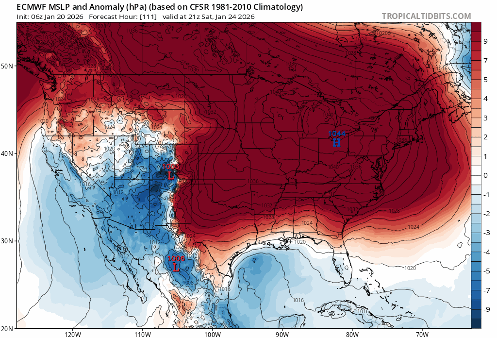
As i loaded up, the first thing i noticed was the high is drastically larger and further west. 1039 to 1046 in MN. Ok, off to look at the models for the next 20 minutes lol.
1 likes
Personal Forecast Disclaimer:
The posts in this forum are NOT official forecast and should not be used as such. They are just the opinion of the poster and may or may not be backed by sound meteorological data. They are NOT endorsed by any professional institution or storm2k.org. For official information, please refer to the NHC and NWS products.
The posts in this forum are NOT official forecast and should not be used as such. They are just the opinion of the poster and may or may not be backed by sound meteorological data. They are NOT endorsed by any professional institution or storm2k.org. For official information, please refer to the NHC and NWS products.

Re: Texas Winter 2025-2026
Ntxw wrote:There were actually changes overnight in the guidance. Reinforcing HP is driving more deeper cold into the system. I would not be surprised of the transition zone continues to shift south with that being the case. DFW is actually not far off from significant amounts of snow and the sleet zone deeper into central Texas.
Yeah I have been expecting this to be the case.
1 likes
Re: Texas Winter 2025-2026
Ntxw wrote:This is why it could get much colder. This is trending to be an absolutely behemoth high pressure system.
https://i.imgur.com/gQJ3kyN.gif
And a second one will drive cold further down, It's a 1-2 punch of snow/ice and then more cold. Dangerous cold set up.
https://i.postimg.cc/zB23rxxV/ecmwf-hp.gif
So we could be looking at temps below freezing longer than anticipated? Especially if snow pack and cloud cover stays around?
0 likes
Re: Texas Winter 2025-2026
As someone who's lived in NTX virtually my entire life and been the victim of numerous winter storm busts, the notable lower risk swath covering the metro made me chuckle a little bit. Almost looks like a dry slot of sorts. The PTSD never ends for us. It's like the weather equivalent of Battered Aggie Syndrome. You just expect things to fall apart, no matter how likely they appear to be lining up just right.
1 likes
Re: Texas Winter 2025-2026
Gotwood wrote:Ntxw wrote:This is why it could get much colder. This is trending to be an absolutely behemoth high pressure system.
https://i.imgur.com/gQJ3kyN.gif
And a second one will drive cold further down, It's a 1-2 punch of snow/ice and then more cold. Dangerous cold set up.
https://i.postimg.cc/zB23rxxV/ecmwf-hp.gif
So we could be looking at temps below freezing longer than anticipated? Especially if snow pack and cloud cover stays around?
Yes, I'd watch for lows to get way down there and rivaling 2021 for some areas with snow and ice up north. It won't be the duration but for a short, sharp time temps will trend colder than what the models have been advertising the past few days. Plenty of time to watch this evolve.
4 likes
The above post and any post by Ntxw is NOT an official forecast and should not be used as such. It is just the opinion of the poster and may or may not be backed by sound meteorological data. It is NOT endorsed by any professional institution including Storm2k. For official information, please refer to NWS products.
Help support Storm2K!
Help support Storm2K!
-
TeamPlayersBlue
- Category 5
- Posts: 3529
- Joined: Tue Feb 02, 2010 1:44 am
- Location: Denver/Applewood, CO
Re: Texas Winter 2025-2026
The crazy lows in Northern Tx i get due to snow being on the ground but the temps in Houston seem much higher than I would expect. Ouachita effect?
What analogs can we throw around? 1997, 2018 are significant ice storms i remember in SE Tx.
What analogs can we throw around? 1997, 2018 are significant ice storms i remember in SE Tx.
0 likes
Personal Forecast Disclaimer:
The posts in this forum are NOT official forecast and should not be used as such. They are just the opinion of the poster and may or may not be backed by sound meteorological data. They are NOT endorsed by any professional institution or storm2k.org. For official information, please refer to the NHC and NWS products.
The posts in this forum are NOT official forecast and should not be used as such. They are just the opinion of the poster and may or may not be backed by sound meteorological data. They are NOT endorsed by any professional institution or storm2k.org. For official information, please refer to the NHC and NWS products.
Re: Texas Winter 2025-2026
Ntxw wrote:Gotwood wrote:Ntxw wrote:This is why it could get much colder. This is trending to be an absolutely behemoth high pressure system.
https://i.imgur.com/gQJ3kyN.gif
And a second one will drive cold further down, It's a 1-2 punch of snow/ice and then more cold. Dangerous cold set up.
https://i.postimg.cc/zB23rxxV/ecmwf-hp.gif
So we could be looking at temps below freezing longer than anticipated? Especially if snow pack and cloud cover stays around?
Yes, I'd watch for lows to get way down there and rivaling 2021 for some areas with snow and ice up north. It won't be the duration but for a short, sharp time temps will trend colder than what the models have been advertising the past few days. Plenty of time to watch this evolve.
Yeah the latest GFS is hinting at the possibility of very low temps and to stay below freezing till Wednesday. We will see how it plays out.
1 likes
-
Tireman4

- S2K Supporter
- Posts: 5903
- Age: 60
- Joined: Fri Jun 30, 2006 1:08 pm
- Location: Humble, Texas
- Contact:
Re: Texas Winter 2025-2026
173
FXUS64 KHGX 201138
AFDHGX
Area Forecast Discussion
National Weather Service Houston/Galveston TX
538 AM CST Tue Jan 20 2026
...New AVIATION...
.KEY MESSAGES...
- Rain chances increase Wednesday in association with a weak
surface trough and some upper disturbances.
- Arctic Front should sag into the region Friday and Friday night,
bringing various winter hazards over the weekend:
- Some prolonged temperatures and potential hard freezes.
- Low Wind Chill Values, potentially between 8-20 degrees.
- Risk of Freezing Rain, Sleet/Ice Pellets
- Hazardous marine conditions.
- Residents are encouraged to winterize their home during the
work week prior to the cold weather arrival.
&&
.DISCUSSION...
Issued at 1236 AM CST Tue Jan 20 2026
A weak frontal boundary will be sagging southward thru the Brazos
Valley down to about the Columbus-Edna area today then
stall/weaken as it looses its southward push. This remnant
boundary/trof, pooling moisture to its east and some weak impulses
aloft should be enough to generate some light precip across the
region Wednesday into Thursday.
Arctic airmass will begin spilling into parts of the region
Friday and Friday night bringing increasingly cold temperatures
and wind chills to the region over the weekend as a 1050mb-ish
high drops SSE out of Canada into the Plains and Midwest. As this
occurs, a mid/upper trough will be making its way eastward from
the SoCal/Baja region along with a moist, active southern stream
overspreading the colder surface airmass and likely bringing a
swath of precipitation to the region Friday, Saturday and parts
of Sunday.
Of course, the column temperature profile at those times will
determine who sees frozen precipitation, what type, how much, and
what times. I`m not going to regurgitate what every 00z
deterministic model is showing...as it`ll be changing with every
6-hour run cycle thru the week. But here are a few highlights on
the broad picture and some talking points at this time:
- Guidance has been showing a consistent signal for an Arctic
airmass overspreading the area this weekend. Freezing
temperatures, possibly some longer durations of sub-freezing
readings, are likely. Potentially dangerous wind chills too.
- Precipitation is also looking likely. As we get closer to the
event, and we get into the window of some of our better high
resolution modeling (late work week or so) we should hopefully
have some better confidence as to what the atmospheric
temperature profile might look like and what form the precip
might take. Have undercut the NBM and ensembles in regards to
surface temps already. For what they`re worth at this point (not
a whole lot), forecast soundings point to decent shots of
freezing rain and maybe some sleet, esp north of I-10...and a
non-zero chance further south. For planning purposes, I might
focus upon late Friday evening into early Sunday afternoon.
- Historically speaking, which may or may not be useful for this
particular event, these shallow cold airmasses typically arrive
faster and are colder than global guidance indicates. It`s also
not uncommon to see some general consistency for several days,
then some runs where guidance looses the signal, before it
magically reappears in later runs. Try not to follow any
individual model suite/run...or individual social media
snapshot. Trends are your friend.
- Residents have time to winterize your home (pipes, sprinkler
systems, etc) for the next several days in your shorts and flip-
flops before the cold air arrives. Recommend using this time to
do so.
47
&&
.AVIATION...
(12Z TAF Issuance)
Issued at 531 AM CST Tue Jan 20 2026
VFR conditions prevail through today. Light and variable winds
will become easterly this morning, and will transition to E/SE
this afternoon at around 10 kts, occasionally gusting to 15 kts.
Increasing cloud cover this afternoon will lead to BKN to OVC
skies. Overnight into Wednesday, expect CIGs to lower to MVFR
levels for the majority of SE Texas beginning anywhere between 4Z
and 6Z. Expect MVFR CIGs to prevail through the end of the TAF
period. Rain will begin to move into the area early Wednesday
morning, increasing in coverage Wednesday morning (past the
current TAF period)
&&
.MARINE...
Issued at 1236 AM CST Tue Jan 20 2026
Mariners should remain mindful of negative tide levels again
today, mainly across the northern bay areas around low tide
cycles. A tightening pressure gradient will lead to some
increasing Gulf winds today. The next shift may need to consider
hoisting the Small Craft Caution flags in the Gulf. A weak
coastal trough is expected to develop and move eastward bring
periods of showers on Wednesday into Thursday. Patchy fog is also
possible Wednesday night and Thursday morning, but conditions do
not appear overly favorable for prolonged stretches of the dense
variety. An Arctic cold front is expected to push into the coastal
waters late Friday or Saturday bringing hazardous marine
conditions: a much colder airmass, strong north winds and
building seas through the weekend. Periods of precipitation are
anticipated through Saturday. Advisories are likely, and Gales
cannot be ruled out. Mariners are advised to keep up with the
latest forecasts. 47
&&
.PRELIMINARY POINT TEMPS/POPS...
College Station (CLL) 63 56 68 55 / 0 30 70 20
Houston (IAH) 67 56 69 60 / 0 20 70 40
Galveston (GLS) 65 59 67 60 / 0 10 70 50
&&
.HGX WATCHES/WARNINGS/ADVISORIES...
TX...None.
GM...Low Water Advisory from 2 PM this afternoon to 6 PM CST this
evening for GMZ335.
&&
$$
DISCUSSION...47
AVIATION...Bailey
MARINE...47
1 likes
-
txtwister78

- Category 5
- Posts: 2169
- Joined: Wed Jan 30, 2019 12:56 pm
- Location: San Antonio
Re: Texas Winter 2025-2026
Yup like clockwork the stronger the arctic high the deeper the cold into Texas and as a result the axis of winter precipitation shifts south.
Probably not done yet considering the globals have adjusted but as mentioned before high resolution models will probably be even quicker with the surge considering the magnitude of the cold now being modeled and thus a faster transition along with that. Lots to watch
Probably not done yet considering the globals have adjusted but as mentioned before high resolution models will probably be even quicker with the surge considering the magnitude of the cold now being modeled and thus a faster transition along with that. Lots to watch
2 likes
Who is online
Users browsing this forum: No registered users and 68 guests