Texas Winter 2025-2026

Winter Weather Discussion

Moderator: S2k Moderators

Forum rules

The posts in this forum are NOT official forecast and should not be used as such. They are just the opinion of the poster and may or may not be backed by sound meteorological data. They are NOT endorsed by any professional institution or STORM2K.

Help Support Storm2K
Message
Author
User avatar
Iceresistance
Category 5
Category 5
Posts: 9491
Age: 22
Joined: Sat Oct 10, 2020 9:45 am
Location: Tecumseh, OK/Norman, OK

Re: Texas Winter 2025-2026

#3021 Postby Iceresistance » Tue Jan 20, 2026 2:14 pm


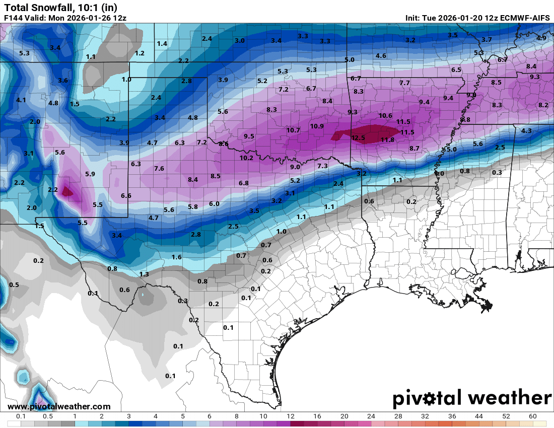
I think the GFS run won't verify, the Euro has other model support like ICON and CMC
0 likes   
Bill 2015 & Beta 2020

Winter 2020-2021 :cold:

All observations are in Tecumseh, OK unless otherwise noted.

Winter posts are focused mainly for Oklahoma & Texas.

Take any of my forecasts with a grain of salt, refer to the NWS, SPC, and NHC for official information

Never say Never with weather! Because ANYTHING is possible!

User avatar
Iceresistance
Category 5
Category 5
Posts: 9491
Age: 22
Joined: Sat Oct 10, 2020 9:45 am
Location: Tecumseh, OK/Norman, OK

Re: Texas Winter 2025-2026

#3022 Postby Iceresistance » Tue Jan 20, 2026 2:16 pm

Oh, and I do want to mention that my family is highly aware of this and are rapidly preparing, we are going to stock up multiple days in advance, as well as getting more gas for the generator (and test starting the generator)
0 likes   
Bill 2015 & Beta 2020

Winter 2020-2021 :cold:

All observations are in Tecumseh, OK unless otherwise noted.

Winter posts are focused mainly for Oklahoma & Texas.

Take any of my forecasts with a grain of salt, refer to the NWS, SPC, and NHC for official information

Never say Never with weather! Because ANYTHING is possible!

User avatar
Ntxw
Storm2k Moderator
Storm2k Moderator
Posts: 23301
Joined: Wed Oct 21, 2009 6:34 pm
Location: DFW, Texas

Re: Texas Winter 2025-2026

#3023 Postby Ntxw » Tue Jan 20, 2026 2:22 pm

We will be within short range hi res guidance soon (hard to believe since it went from nothing to 100mph metaphorically speaking) and with such a set up like this, each impulse will play a role both qpf and dynamics...and there will be many of them. This stuff is difficult to model. Feb 2010 in DFW for example. The low was so slow and the stj just kept coming. I suspect a similar long drawn out process to the like.
5 likes   
The above post and any post by Ntxw is NOT an official forecast and should not be used as such. It is just the opinion of the poster and may or may not be backed by sound meteorological data. It is NOT endorsed by any professional institution including Storm2k. For official information, please refer to NWS products.

  Help support Storm2K!
Help Support Storm2K

Ralph's Weather
S2K Supporter
S2K Supporter
Posts: 3316
Age: 38
Joined: Fri Dec 13, 2013 11:55 am
Location: Lindale, TX
Contact:

Re: Texas Winter 2025-2026

#3024 Postby Ralph's Weather » Tue Jan 20, 2026 2:26 pm

SHV with the watch now
0 likes   
Follow on Facebook at Ralph's Weather.

User avatar
TheAustinMan
Category 5
Category 5
Posts: 1060
Joined: Mon Jul 08, 2013 4:26 pm
Location: Central TX / United States

Re: Texas Winter 2025-2026

#3025 Postby TheAustinMan » Tue Jan 20, 2026 2:26 pm

Reconnaissance has been tasked to investigate the shortwave trough off California tomorrow afternoon/evening. The mission is to deploy about 25 dropsondes to sample the system, and hopefully we'll be able to get a better read on how it evolves once this data feeds the models. The placement, intensity, and structure of the trough tomorrow is critical not just for how the winter event unfolds over Texas, but also on downstream precipitation across the Southeastern US. I'd imagine that linked ensemble sensitivity analysis played into the mission being planned for tomorrow... after all, Texas is on the western end of what could be a very impactful winter weather event for much of the eastern US.

As an aside, the experimental 12Z NSSL MPAS-based convective allowing models are running, which go out 84 hours from initialization. That should give us our first mesoscale, convective-allowing hi-res taste of what the beginning of this event could look like. Pivotal is a good place to view these (NSSL MPAS-RN, NSSL MPAS-RN3).

NOUS42 KNHC 201742
REPRPD
WEATHER RECONNAISSANCE FLIGHTS
CARCAH, NATIONAL HURRICANE CENTER, MIAMI, FL.
1245 PM EST TUE 20 JANUARY 2026
SUBJECT: WINTER SEASON PLAN OF THE DAY (WSPOD)
VALID 21/1100Z TO 22/1100Z JANUARY 2026
WSPOD NUMBER.....25-051

I. ATLANTIC REQUIREMENTS
1. NEGATIVE RECONNAISSANCE REQUIREMENTS.
2. OUTLOOK FOR SUCCEEDING DAY: POSSIBLE MISSIONS ALONG TRACK 66
FOR 23/0000Z AND 23/1200Z.

II. PACIFIC REQUIREMENTS
1. FLIGHT ONE - TEAL 74
A. 22/0000Z
B. AFXXX 11WSE IOP10
C. 21/1900Z
D. 25 DROPS APPROXIMATELY 60 NM APART WITHIN AN AREA BOUNDED
BY: 25.0N 140.0W, 25.0N 120.0W, 40.0N 120.0W, AND 40.0N 140.0W
E. AS HIGH AS POSSIBLE/ 21/2030Z TO 22/0230Z


2. SUCCEEDING DAY OUTLOOK: A USAF WC-130J AIRCRAFT MAY FLY AN
ATMOSPHERIC RIVERS MISSIONS OVER THE EASTERN PACIFIC FOR THE
23/0000Z SYNOPTIC TIME.
3. ADDITIONAL DAY OUTLOOK: A USAF WC-130J AIRCRAFT MAY FLY AN
ATMOSPHERIC RIVERS MISSION OVER THE EASTERN PACIFIC FOR THE
24/0000Z SYNOPTIC TIME.

$$
10 likes   
Treat my opinions with a grain of salt. For official information see your local weather service.
“It's tough to make predictions, especially about the future.”

rwfromkansas
Category 5
Category 5
Posts: 2879
Joined: Sat Aug 27, 2005 12:47 am
Location: North Fort Worth

Re: Texas Winter 2025-2026

#3026 Postby rwfromkansas » Tue Jan 20, 2026 2:31 pm

It is still hard to believe this all started Sunday morning. I thought Saturday in my mind. No, it was Sunday. We have added 41 pages since that time...

FYI Delkus has changed to his silly snow avatar.
4 likes   

User avatar
Iceresistance
Category 5
Category 5
Posts: 9491
Age: 22
Joined: Sat Oct 10, 2020 9:45 am
Location: Tecumseh, OK/Norman, OK

Re: Texas Winter 2025-2026

#3027 Postby Iceresistance » Tue Jan 20, 2026 2:33 pm

Significant widespread snow is likely Friday in the weekend.
Ensemble probabilities are showing 60-80% chance of 6+ inch
snow over a broad swath of Oklahoma and 30-50% chance of 12+
inch bands somewhere in Oklahoma (highest along the I-40
corridor).

NWS-Norman AFD, so you're telling me there's a chance?
0 likes   
Bill 2015 & Beta 2020

Winter 2020-2021 :cold:

All observations are in Tecumseh, OK unless otherwise noted.

Winter posts are focused mainly for Oklahoma & Texas.

Take any of my forecasts with a grain of salt, refer to the NWS, SPC, and NHC for official information

Never say Never with weather! Because ANYTHING is possible!

mmmmsnouts
Tropical Storm
Tropical Storm
Posts: 201
Joined: Tue Sep 05, 2023 10:04 pm
Location: Arlington, TX

Re: Texas Winter 2025-2026

#3028 Postby mmmmsnouts » Tue Jan 20, 2026 2:34 pm

rwfromkansas wrote:FYI Delkus has changed to his silly snow avatar.


Delkus’s big tell is sleeve length. If he just rolls up the cuffs a little bit, this will be a nothing burger. If he rolls up his sleeves almost to his elbows, then we’re all gonna die.
4 likes   

rwfromkansas
Category 5
Category 5
Posts: 2879
Joined: Sat Aug 27, 2005 12:47 am
Location: North Fort Worth

Re: Texas Winter 2025-2026

#3029 Postby rwfromkansas » Tue Jan 20, 2026 2:39 pm

The WPC saying there's only a maybe 20 percent chance of moderate impacts in DFW is wild. They are out to lunch.
2 likes   

User avatar
Quixotic
Category 3
Category 3
Posts: 832
Joined: Tue Feb 14, 2017 12:27 am
Location: Frisco

Re: Texas Winter 2025-2026

#3030 Postby Quixotic » Tue Jan 20, 2026 2:40 pm

mmmmsnouts wrote:
rwfromkansas wrote:FYI Delkus has changed to his silly snow avatar.


Delkus’s big tell is sleeve length. If he just rolls up the cuffs a little bit, this will be a nothing burger. If he rolls up his sleeves almost to his elbows, then we’re all gonna die.


This made me chuckle
2 likes   

User avatar
CaptinCrunch
S2K Supporter
S2K Supporter
Posts: 8756
Age: 57
Joined: Mon Nov 03, 2003 4:33 pm
Location: Kennedale, TX (Tarrant Co.)

Re: Texas Winter 2025-2026

#3031 Postby CaptinCrunch » Tue Jan 20, 2026 2:42 pm

Ntxw wrote:We will be within short range hi res guidance soon (hard to believe since it went from nothing to 100mph metaphorically speaking) and with such a set up like this, each impulse will play a role both qpf and dynamics...and there will be many of them. This stuff is difficult to model. Feb 2010 in DFW for example. The low was so slow and the stj just kept coming. I suspect a similar long drawn out process to the like.


Grandpa always said, "don't start counting your chickens until all the eggs have hatched" and all the eggs should be hatched by Thursday evening. With that said I'm not stating anything until till I see the models from mid-day Thursday.

as NTWX stated, Jan 2010 storm that dropped wide spread 12" of snow is a great example of a system that did it's own thing regardless of what the models said 12 hrs earlier. What was originally forecast as a dusting to 1-2" turned into a game of catch-up by NWS as well as our local WX forecasters. It's rare but storm systems can buck the models and give everyone something they wasn't counting on.

:double: :froze:
2 likes   

User avatar
Quixotic
Category 3
Category 3
Posts: 832
Joined: Tue Feb 14, 2017 12:27 am
Location: Frisco

Re: Texas Winter 2025-2026

#3032 Postby Quixotic » Tue Jan 20, 2026 2:43 pm

2021 was bad but NYE 1978 was much much worse. No power for six days. All the trees split in half. I couldn’t leave the house because of all the live lines spitting sparks everywhere. Six days, two parents and 7 of us kids. My fish tank froze into a block of ice.
0 likes   

User avatar
Tireman4
S2K Supporter
S2K Supporter
Posts: 5894
Age: 60
Joined: Fri Jun 30, 2006 1:08 pm
Location: Humble, Texas
Contact:

Re: Texas Winter 2025-2026

#3033 Postby Tireman4 » Tue Jan 20, 2026 2:46 pm

43
FXUS64 KHGX 201936
AFDHGX

Area Forecast Discussion
National Weather Service Houston/Galveston TX
136 PM CST Tue Jan 20 2026

...New DISCUSSION, MARINE...

.KEY MESSAGES...

- Rain chances increase tonight into Wednesday in association
with a weak surface trough and some upper disturbances.

- Arctic Front should sag into the region Friday and Friday night,
bringing various winter hazards over the weekend:
- Some prolonged temperatures and potential hard freezes.
- Low Wind Chill Values, potentially between 7-20 degrees.
- Risk of Freezing Rain, Sleet/Ice Pellets
- Hazardous marine conditions.

- Residents are encouraged to winterize their home during the
work week prior to the cold weather arrival.

&&

.DISCUSSION...
Issued at 136 PM CST Tue Jan 20 2026

Today through Thursday:

A weak front remains stalled across the area today. A few showers
have developed in the vicinity of Matagorda Bay in a low-level
confluence zone and have raised PoPs in that area for the rest of
the day. Tonight and tomorrow a couple shortwaves in the northern
stream will have a glancing influence on our northern counties,
while some weak southern stream disturbances have a glancing
influence on our southern counties with overall cyclonic flow
aloft across the forecast area. As this occurs southerly low-level
flow will strengthen and push the front northward as a warm front.
This will cause some drizzle/light showers to develop overnight
tonight with the highest chances in our far northern counties.
Scattered to numerous showers will continue across much of the
area Wednesday into Wednesday evening. Some weak instability will
be present for a small chance of a thunderstorm but HREF thunder
probabilities are only 10 percent or less. Generally warmer
temperatures are expected, though if coverage of rain ends up
being higher than high temperatures could end up lower than
forecast. The front drifts back to the southeast as a cold front
but quickly stalls. With the stalled front in the area some low
rain chances continue into Thursday.

Friday through Monday:

Attention then quickly turns to the winter storm that will impact
much of the southern CONUS as we go into the weekend. A cutoff low
will drift slowly eastward off the coast of California and the
Baja, resulting in persistent moist southwest flow
aloft/isentropic lift downstream. Meanwhile at the surface a very
strong 1050+ mb Arctic high will build southward across the
Central CONUS, with a shallow Arctic airmass moving underneath
warm air advection aloft. Rain will overspread the area
Friday/Friday night as the Arctic front moves in. Temperatures
look to drop below freezing in the far northern counties as early
as Friday night or as late as during the day on Saturday morning.
This will be the main thing to watch as we get closer, since
models often struggle with the timing of shallow Arctic air
masses. Forecast soundings indicate a large warm nose aloft that
will melt any snowflakes, with a predominant precip type of
freezing rain. In the northern counties there will also be the
potential for a changeover to sleet as the low-level cold air mass
deepens. Temperatures won`t warm up much on Saturday and will be
falling in many areas during the afternoon.

Temperatures really start to drop on Saturday night though there
starts to be quite a bit of spread in temperatures in the guidance
by this point. This will result in the potential for wintry
precipitation to expand to cover much of the rest of the forecast
area. It is interesting to note that some guidance does indicate a
dry layer at 700mb pushing in, which is why current ensemble
blends show a decrease in PoPs. However, there remains quite a bit
of moisture above and below this layer, and even light freezing
rain/freezing drizzle at these temperatures could have significant
impacts. Additionally, any remaining water on roadways from
earlier rain will have the potential to refreeze. The current
forecast shows precipitation chances tapering off from northwest
to southeast by Sunday though there remains quite a bit of spread
in the guidance. Will keep in mind that any time a cutoff low is
involved there is always the potential for systems to slow down.

The latest probabilistic WSSI shows medium to high chances
(40-70%) of at least minor winter weather impacts for areas along
and north of I-10, with at least low (20%) chances extending
southward towards the coast. Probabilities for "moderate" winter
weather impacts are 20-30% across northern portions of the
forecast area. However, it is important to note that WSSI can
under-do impacts for freezing rain since small amounts of ice
accumulation can have big travel impacts. It`s too early for any
Winter Storm Watches at this time, but those will probably
eventually be needed for at least part of the CWA in the next day
or two. Current forecast winds are sustained around 10-12 kts with
gust to 20kts, which may also aid in power outages.

While there is a understandably a lot of focus on the wintry
precipitation, it is also important to focus on the dangerously
cold temperatures also occurring with this system. Hard freeze
conditions (temperatures below 24 degrees) are expected across
portions of the area Saturday, Sunday, and Monday nights, with the
coldest temperatures/most widespread temperatures below 24 degrees
Sunday night. Forecast lows in northern portions of the area are
in the teens on those nights. Dangerously cold wind chills are
also forecast, with the lowest values Sunday morning ranging from
the single digits north to the teens south. At minimum widespread
Cold Weather Advisories (wind chills below 20 north/25 south)
will likely be needed. Additionally, some Extreme Cold Warnings
(wind chills below 10 north/15 south) will probably be needed.

Make sure to continue to check back for the latest forecasts with
system since it is still a few days away and forecasts will likely
change. Now is the time to begin to prepare.

JDavis

&&

.AVIATION...
(12Z TAF Issuance)
Issued at 531 AM CST Tue Jan 20 2026

VFR conditions prevail through today. Light and variable winds
will become easterly this morning, and will transition to E/SE
this afternoon at around 10 kts, occasionally gusting to 15 kts.
Increasing cloud cover this afternoon will lead to BKN to OVC
skies. Overnight into Wednesday, expect CIGs to lower to MVFR
levels for the majority of SE Texas beginning anywhere between 4Z
and 6Z. Expect MVFR CIGs to prevail through the end of the TAF
period. Rain will begin to move into the area early Wednesday
morning, increasing in coverage Wednesday morning (past the
current TAF period)

&&

.MARINE...
Issued at 136 PM CST Tue Jan 20 2026

Mariners should remain mindful of negative tide levels again
today, mainly across the northern bay areas around low tide
cycles. A tightening pressure gradient will lead to some
increasing Gulf winds today. A Small Craft Caution has been issued
for the Gulf waters for winds of 15-20 kts. A weak coastal trough
is expected to develop and move eastward bringing periods of
showers on Wednesday into Thursday. Patchy fog is also possible
Wednesday night and Thursday morning, but conditions do not appear
overly favorable for prolonged stretches of the dense variety. An
Arctic cold front is expected to push into the coastal waters
late Friday or Saturday bringing hazardous marine conditions: a
much colder airmass, strong north winds and building seas through
the weekend. Periods of precipitation are anticipated through
Saturday. Advisories are likely, and Gales cannot be ruled out.
Mariners are advised to keep up with the latest forecasts.

&&

.PRELIMINARY POINT TEMPS/POPS...
College Station (CLL) 55 67 55 73 / 40 60 30 10
Houston (IAH) 57 69 60 74 / 20 70 40 20
Galveston (GLS) 59 68 58 68 / 20 70 50 30

&&

.HGX WATCHES/WARNINGS/ADVISORIES...
TX...None.
GM...Low Water Advisory until 6 PM CST this evening for GMZ335.

&&

$$

DISCUSSION...JDavis
AVIATION...Bailey
MARINE...JDavis
0 likes   

User avatar
Tireman4
S2K Supporter
S2K Supporter
Posts: 5894
Age: 60
Joined: Fri Jun 30, 2006 1:08 pm
Location: Humble, Texas
Contact:

Re: Texas Winter 2025-2026

#3034 Postby Tireman4 » Tue Jan 20, 2026 2:47 pm

The latest probabilistic WSSI shows medium to high chances
(40-70%) of at least minor winter weather impacts for areas along
and north of I-10, with at least low (20%) chances extending
southward towards the coast. Probabilities for "moderate" winter
weather impacts are 20-30% across northern portions of the
forecast area. However, it is important to note that WSSI can
under-do impacts for freezing rain since small amounts of ice
accumulation can have big travel impacts. It`s too early for any
Winter Storm Watches at this time, but those will probably
eventually be needed for at least part of the CWA in the next day
or two. Current forecast winds are sustained around 10-12 kts with
gust to 20kts, which may also aid in power outages.


While there is a understandably a lot of focus on the wintry
precipitation, it is also important to focus on the dangerously
cold temperatures also occurring with this system. Hard freeze
conditions (temperatures below 24 degrees) are expected across
portions of the area Saturday, Sunday, and Monday nights, with the
coldest temperatures/most widespread temperatures below 24 degrees
Sunday night. Forecast lows in northern portions of the area are
in the teens on those nights. Dangerously cold wind chills are
also forecast, with the lowest values Sunday morning ranging from
the single digits north to the teens south. At minimum widespread
Cold Weather Advisories (wind chills below 20 north/25 south)
will likely be needed. Additionally, some Extreme Cold Warnings
(wind chills below 10 north/15 south) will probably be needed.

Make sure to continue to check back for the latest forecasts with
system since it is still a few days away and forecasts will likely
change. Now is the time to begin to prepare.
0 likes   

User avatar
bubba hotep
S2K Supporter
S2K Supporter
Posts: 5918
Joined: Wed Dec 28, 2016 1:00 am
Location: Collin County Texas

Re: Texas Winter 2025-2026

#3035 Postby bubba hotep » Tue Jan 20, 2026 2:54 pm

12z Euro AI, for reference it had no snow for much of North Texas 24 hours ago

Image
6 likes   
Winter time post are almost exclusively focused on the DFW area.

HockeyTx82
S2K Supporter
S2K Supporter
Posts: 2701
Joined: Tue Oct 27, 2009 11:17 am
Location: Ponder, TX

Re: Texas Winter 2025-2026

#3036 Postby HockeyTx82 » Tue Jan 20, 2026 2:58 pm

523 guests.......
5 likes   
Don't hold me accountable for anything I post on this forum. Leave the real forecasting up to the professionals.

Location: Ponder, TX (all observation posts are this location unless otherwise noted)

Brent
S2K Supporter
S2K Supporter
Posts: 38590
Age: 37
Joined: Sun May 16, 2004 10:30 pm
Location: Tulsa Oklahoma
Contact:

Re: Texas Winter 2025-2026

#3037 Postby Brent » Tue Jan 20, 2026 2:59 pm

Winter Storm Watch here already :double:

I had a feeling they would do it early with the models
2 likes   
#neversummer

BTAYLOR5021
Tropical Low
Tropical Low
Posts: 49
Joined: Mon Jan 09, 2017 9:34 am

Re: Texas Winter 2025-2026

#3038 Postby BTAYLOR5021 » Tue Jan 20, 2026 3:03 pm

Winter Storm watch Issued for DFW….
3 likes   

User avatar
Texas Snow
S2K Supporter
S2K Supporter
Posts: 804
Joined: Mon Oct 19, 2015 12:06 pm
Location: N. Dallas & Cedar Creek Lake

Re: Texas Winter 2025-2026

#3039 Postby Texas Snow » Tue Jan 20, 2026 3:05 pm

URGENT - WINTER WEATHER MESSAGE
National Weather Service Fort Worth TX
201 PM CST Tue Jan 20 2026

TXZ091>095-100>107-115>123-129>135-141>148-156>162-174-175-210915-
/O.NEW.KFWD.WS.A.0001.260123T1800Z-260125T1200Z/
Montague-Cooke-Grayson-Fannin-Lamar-Young-Jack-Wise-Denton-Collin-
Hunt-Delta-Hopkins-Stephens-Palo Pinto-Parker-Tarrant-Dallas-
Rockwall-Kaufman-Van Zandt-Rains-Eastland-Erath-Hood-Somervell-
Johnson-Ellis-Henderson-Comanche-Mills-Hamilton-Bosque-Hill-
Navarro-Freestone-Anderson-Lampasas-Coryell-Bell-McLennan-Falls-
Limestone-Leon-Milam-Robertson-
Including the cities of Decatur, Teague, Bonham, Dublin,
Rockdale, Edgewood, Valley Mills, Graham, Groesbeck, Midlothian,
Mineral Wells, Oak Trail Shores, Gatesville, Breckenridge, Ennis,
Denison, Cisco, Kaufman, Stephenville, Oakwood, Killeen,
Normangee, Hearne, Forney, Marlin, Plano, Jacksboro, Goldthwaite,
Rockwall, McKinney, Gun Barrel City, Bridgeport, Fort Worth,
Bowie, Heath, East Tawakoni, Temple, Burleson, Gainesville,
Arlington, Van, Olney, Dallas, Centerville, Fairfield, Gorman,
Athens, Corsicana, Frisco, Wortham, Nocona, De Leon, Carrollton,
Calvert, Allen, Commerce, Terrell, Paris, Glen Rose, Sulphur
Springs, Briar, Denton, Jewett, Copperas Cove, Hamilton,
Lewisville, Ranger, Meridian, Waco, Flower Mound, Weatherford,
Hico, Cooper, Comanche, Cleburne, Buffalo, Mexia, Franklin,
Granbury, Cameron, Sherman, Clifton, Point, Canton, Waxahachie,
Fort Hood, Palestine, Wills Point, Emory, Greenville, Hillsboro,
Lampasas, Grand Saline, and Eastland
201 PM CST Tue Jan 20 2026

...WINTER STORM WATCH IN EFFECT FROM FRIDAY AFTERNOON THROUGH LATE
SATURDAY NIGHT...

* WHAT...Moderate to heavy accumulations of snow, sleet, or ice are
likely across the region Friday through Saturday night. In
addition, dangerous cold temperatures are expected Saturday night
through Monday morning.

* WHERE...All of North and Central Texas.

* WHEN...From Friday afternoon through late Saturday night.

* IMPACTS...Roads, especially bridges and overpasses, will likely
become dangerous. Significant ice accumulation on power lines and
tree limbs may cause power outages. Extreme cold will become life
threatening and likely damage unprotected pipes and put livestock
at risk.

PRECAUTIONARY/PREPAREDNESS ACTIONS...

Monitor the latest forecasts for updates on this situation. Have an
emergency kit ready. Make winter preparations to home and business
before Friday. Check on vulnerable friends and family. Consider
delaying or altering weekend travel plans.

&&

$$

Sanchez
0 likes   
"Don't let wishcastin get in the way of your forecastin"

Image

Ralph's Weather
S2K Supporter
S2K Supporter
Posts: 3316
Age: 38
Joined: Fri Dec 13, 2013 11:55 am
Location: Lindale, TX
Contact:

Re: Texas Winter 2025-2026

#3040 Postby Ralph's Weather » Tue Jan 20, 2026 3:06 pm

Not often that you will see NWS issue winter storm watches at max range around here. Goes to show what we already know here. There is very high confidence in a region wide winter storm.
5 likes   
Follow on Facebook at Ralph's Weather.


Return to “Winter Weather”

Who is online

Users browsing this forum: Brazoria979cnty, Lagreeneyes03, Tammie and 184 guests