Significant widespread snow is likely Friday in the weekend.
Ensemble probabilities are showing 60-80% chance of 6+ inch
snow over a broad swath of Oklahoma and 30-50% chance of 12+
inch bands somewhere in Oklahoma (highest along the I-40
corridor).
Moderator: S2k Moderators
 The posts in this forum are NOT official forecast and should not be used as such. They are just the opinion of the poster and may or may not be backed by sound meteorological data. They are NOT endorsed by any professional institution or STORM2K.
 Significant widespread snow is likely Friday in the weekend.


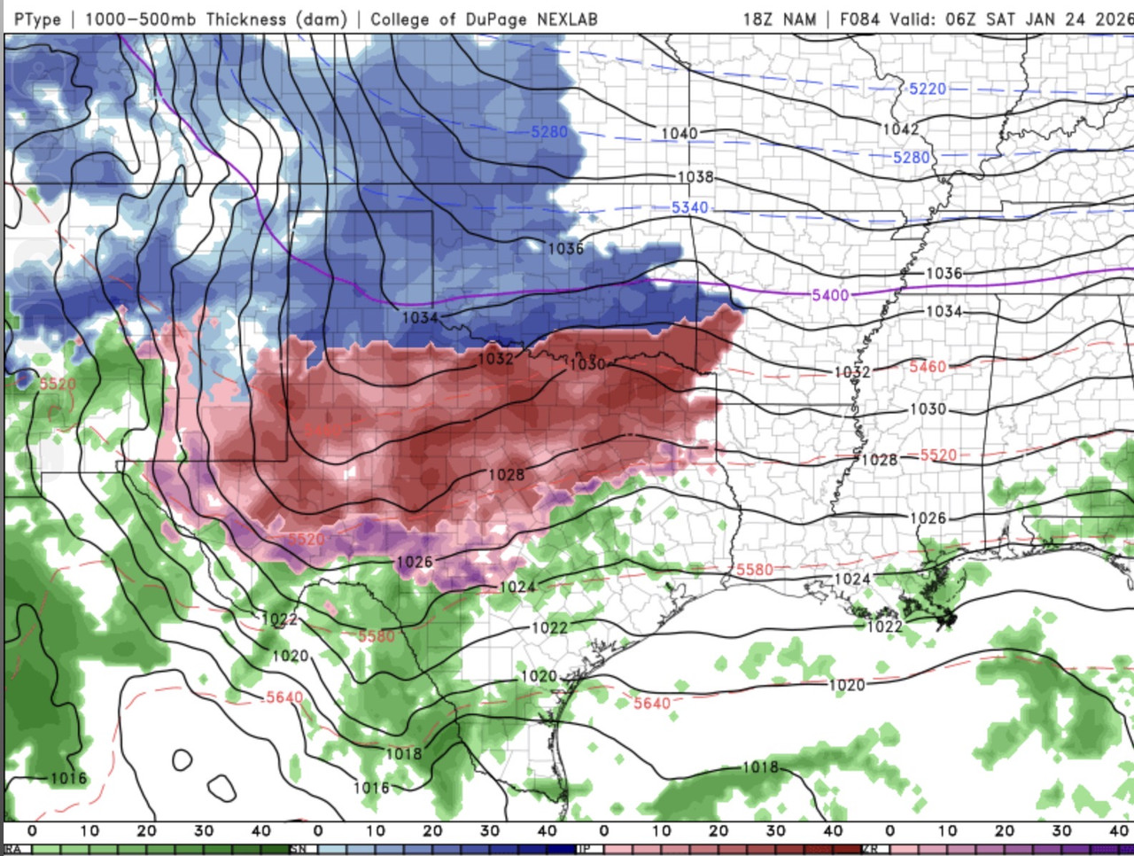
snownado wrote:Early frames of the NAM (18z) are quite stout with the warm layer aloft.


wxman57 wrote:Here are all the model forecasts for Houston. Note the Canadian is the extreme outlier, as it always is here with such events. Discard it immediately. UKMET (gray line) is way too warm at the start, too cold in the middle, and too warm at the end of the graphic. National Blend of Models (NBM) has Houston below freezing from 3am Sunday to 12pm Monday. Note that these are 6hr data points, meaning no 21Z points, so it's possible the temperature could be a deg or two higher in mid afternoon. NBM has an inch or two of snow in D-FW area and about a tenth of an inch of freezing rain here in Houston. I suspect elevated roads will become icy in Houston Saturday evening. I'm not seeing enough freezing rain for power outages yet, but I wouldn't rule out 1/4" of freezing rain or more here. I'll be nice and warm with my generator running if there is a power outage. No need to fly to Australia this time.
https://wxman57.com/images/12ZJan20Models.jpg
https://wxman57.com/images/12ZJan20Models.jpg
HockeyTx82 wrote:wxman57 wrote:Here are all the model forecasts for Houston. Note the Canadian is the extreme outlier, as it always is here with such events. Discard it immediately. UKMET (gray line) is way too warm at the start, too cold in the middle, and too warm at the end of the graphic. National Blend of Models (NBM) has Houston below freezing from 3am Sunday to 12pm Monday. Note that these are 6hr data points, meaning no 21Z points, so it's possible the temperature could be a deg or two higher in mid afternoon. NBM has an inch or two of snow in D-FW area and about a tenth of an inch of freezing rain here in Houston. I suspect elevated roads will become icy in Houston Saturday evening. I'm not seeing enough freezing rain for power outages yet, but I wouldn't rule out 1/4" of freezing rain or more here. I'll be nice and warm with my generator running if there is a power outage. No need to fly to Australia this time.
https://wxman57.com/images/12ZJan20Models.jpg
https://wxman57.com/images/12ZJan20Models.jpg
Wait so DFW has trended down in totals now?
snownado wrote:snownado wrote:Early frames of the NAM (18z) are quite stout with the warm layer aloft.
18z NAM is also a good several degrees warmer than the GFS at the same time at the surface.
As the NAM tends to do the better job of handling these shallow arctic airmasses, its current solution is not exactly the best sign.
But again, still very early frames.


snownado wrote:snownado wrote:snownado wrote:Early frames of the NAM (18z) are quite stout with the warm layer aloft.
18z NAM is also a good several degrees warmer than the GFS at the same time at the surface.
As the NAM tends to do the better job of handling these shallow arctic airmasses, its current solution is not exactly the best sign.
But again, still very early frames.
[url]https://i.ibb.co/Y7w5X2CN/Screenshot-2026-01-20-145534.png [/url]
[url]https://i.ibb.co/jPsCjGH8/Screenshot-2026-01-20-145607.png [/url]
[url]https://i.ibb.co/Fvz2n59/Screenshot-2026-01-20-145756.png [/url]
[url]https://i.ibb.co/GQqXF8mt/Screenshot-2026-01-20-145701.png [/url]
Users browsing this forum: No registered users and 34 guests