Texas Winter 2025-2026
Moderator: S2k Moderators
Forum rules
 The posts in this forum are NOT official forecast and should not be used as such. They are just the opinion of the poster and may or may not be backed by sound meteorological data. They are NOT endorsed by any professional institution or STORM2K.

The posts in this forum are NOT official forecast and should not be used as such. They are just the opinion of the poster and may or may not be backed by sound meteorological data. They are NOT endorsed by any professional institution or STORM2K.


Re: Texas Winter 2025-2026
When almost every member of every model shows a storm, you can see why FWD went early. I’m right on the sleet snow line so my concerns are a bit different than others. Be nice to see convective sleet or snow.
6 likes
-
TeamPlayersBlue

- Category 5

- Posts: 3529
- Joined: Tue Feb 02, 2010 1:44 am
- Location: Denver/Applewood, CO
Re: Texas Winter 2025-2026
The heaviest precip I believe will be jet induced. The right entrance quadrant of the jet will be the bullseye of much of the moisture. It will be both jet induced and lift from the sir rising over the dense HP, but the core will be jet induced. That's why the main precip area is shifting around some. Hasn't quite zeroed in on where they main jet dynamics will be.
This is something I've learned while here in Denver. This often leads to a "stripe" of moisture for some lucky people underneath the jet. I was blessed to be in the bullseye of one of these events. Ended up with 10" of completely unexpected snow. Just 3 miles away, only had 1-2".
Any of you mets, which are much smarter than me, feel free to correct or modify my post on it!
1 likes
Personal Forecast Disclaimer:
The posts in this forum are NOT official forecast and should not be used as such. They are just the opinion of the poster and may or may not be backed by sound meteorological data. They are NOT endorsed by any professional institution or storm2k.org. For official information, please refer to the NHC and NWS products.
The posts in this forum are NOT official forecast and should not be used as such. They are just the opinion of the poster and may or may not be backed by sound meteorological data. They are NOT endorsed by any professional institution or storm2k.org. For official information, please refer to the NHC and NWS products.
-
orangeblood
- S2K Supporter

- Posts: 3895
- Joined: Tue Dec 15, 2009 6:14 pm
- Location: Fort Worth, TX
Re: Texas Winter 2025-2026
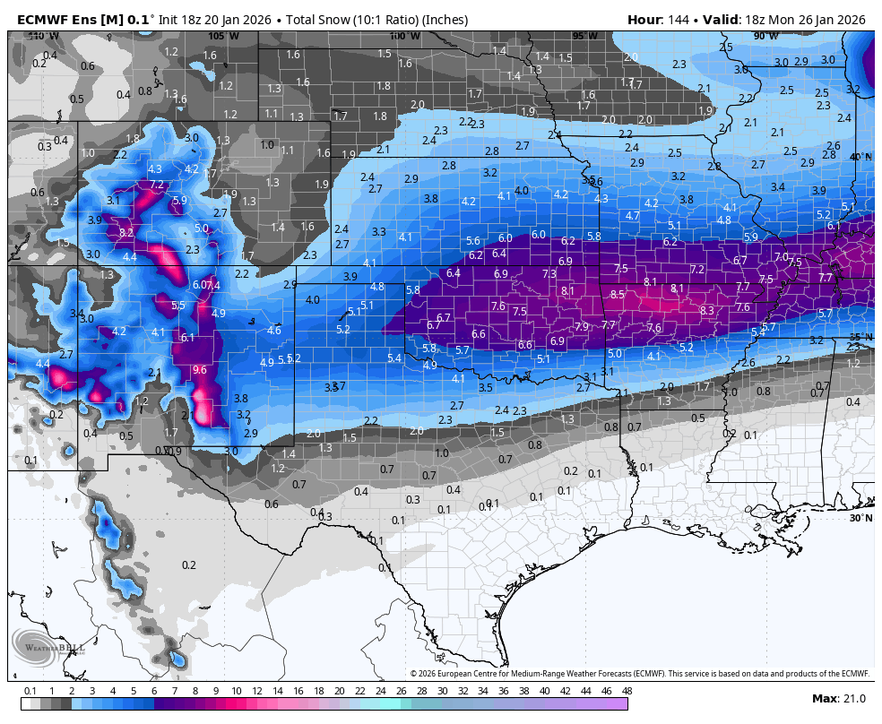
Latest Euro ENS continues to expand the snow field north and south, amazing!
3 likes
-
wxman22

- Category 5
- Posts: 1902
- Joined: Mon Jan 30, 2006 12:39 am
- Location: Wichita Falls, TX
- Contact:
Re: Texas Winter 2025-2026
Temps look to be in the mid teens here during the peak of the storm on Saturday. Ratios are going to be crazy high.I need to check the dendrite growing zone on the models to see if we can get some fat flakes.The high Precipitable Water will help.
2 likes
-
rwfromkansas
- Category 5
- Posts: 3028
- Joined: Sat Aug 27, 2005 12:47 am
- Location: North Fort Worth
Re: Texas Winter 2025-2026
Nearly all my social media feed is on the storm; don't recall that even before 2021. The hype is high. My wife said HEB was a zoo tonight, even more than usual.
3 likes


Re: Texas Winter 2025-2026
SPV reversal/split is looking stronger for early Feb at 10mb. That will likely result in -AO driven pattern the 2nd week of Feb into mid month.
4 likes
The above post and any post by Ntxw is NOT an official forecast and should not be used as such. It is just the opinion of the poster and may or may not be backed by sound meteorological data. It is NOT endorsed by any professional institution including Storm2k. For official information, please refer to NWS products.
Help support Storm2K!

Re: Texas Winter 2025-2026
2" of freezing rain would be hell - but that's more rain than we've gotten in the last two months combined - so there's that.
2 likes
The above post and any post by dhweather is NOT an official forecast and should not be used as such. It is just the opinion of the poster and may or may not be backed by sound meteorological data. It is NOT endorsed by any professional institution including storm2k.org. For official information, please refer to NWS products.
Re: Texas Winter 2025-2026
Also next week a 1055-1060+ HP dome is now shown by models to sit over the Beaufort Sea/high arctic vicinity. Should that connect to our side then the next cold wave to end the month might be a little more impressive than guidance is currently showing.

6 likes
The above post and any post by Ntxw is NOT an official forecast and should not be used as such. It is just the opinion of the poster and may or may not be backed by sound meteorological data. It is NOT endorsed by any professional institution including Storm2k. For official information, please refer to NWS products.
Help support Storm2K!
Help support Storm2K!
-
Stratton23
- Category 5
- Posts: 3525
- Joined: Fri Jul 21, 2023 10:59 pm
- Location: Katy, Tx
Re: Texas Winter 2025-2026
Ntxw that would be insane, talk about winter roaring like a Lion now, not to mention the likely PV split in early february, could be one of the craziest back loaded winters we have had in some time
4 likes
Re: Texas Winter 2025-2026
Stratton23 wrote:Ntxw that would be insane, talk about winter roaring like a Lion now, not to mention the likely PV split in early february, could be one of the craziest back loaded winters we have had in some time
+PNA flavor in a La Nina -PDO usually doesn't serve us well. But the current set up as you can see the +PNA is coupled with a strong STJ more like the El Nino's we all know and love which pulls troughs back with their Baja lows. We're definitely moving towards enso neutral with some Nina influences still ongoing. 1957, 1997, 2015 had some cold finishes well into March and April some years that shifted from one enso to another.
I am hoping this system is the harbinger of change in terms of a more wet regime in the months ahead, perhaps we are finally crossing that line.
7 likes
The above post and any post by Ntxw is NOT an official forecast and should not be used as such. It is just the opinion of the poster and may or may not be backed by sound meteorological data. It is NOT endorsed by any professional institution including Storm2k. For official information, please refer to NWS products.
Help support Storm2K!
Help support Storm2K!
-
orangeblood
- S2K Supporter
- Posts: 3895
- Joined: Tue Dec 15, 2009 6:14 pm
- Location: Fort Worth, TX
Re: Texas Winter 2025-2026
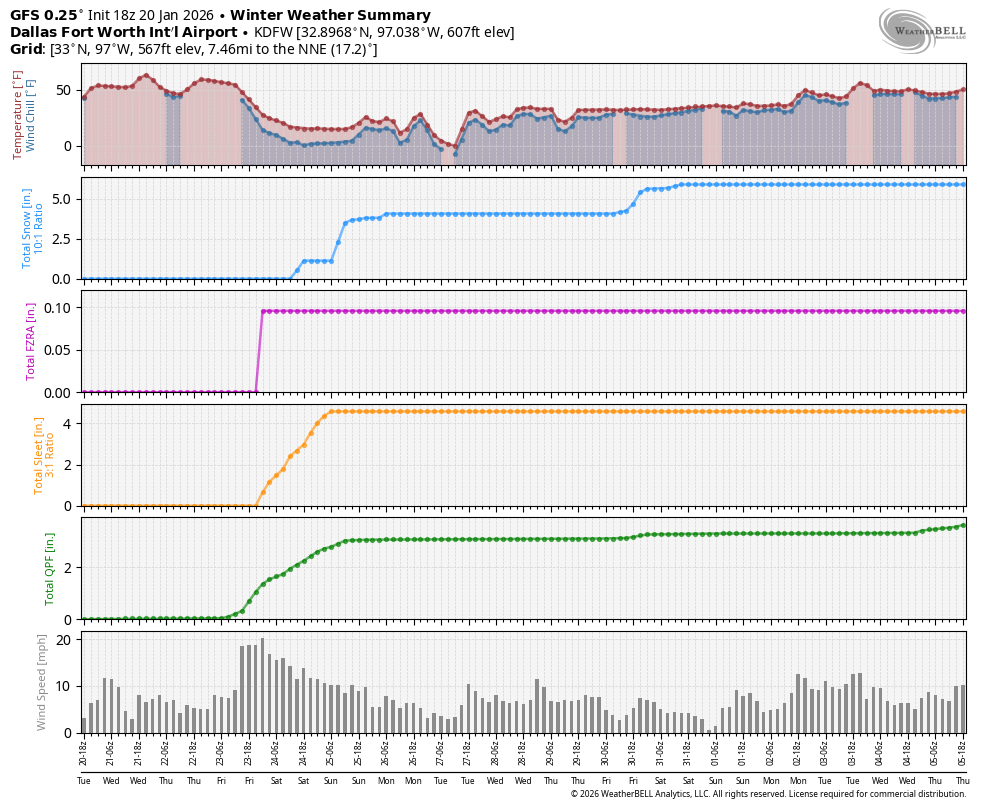
Model algos are going to have fits trying to decipher these precip types. Overall GFS is probably best at this range to handle surface depictions until we get into high res range later tomorrow. It currently has 0.10” frz rain, 5” sleet and almost 3 inches of snow at DFW…that would cause a major shutdown across the metroplex and seems like the most sensible solution with a 3:1 sleet ratio .
Austin to Houston is a really tough forecast
Austin to Houston is a really tough forecast
6 likes
-
bubba hotep

- S2K Supporter
- Posts: 6013
- Joined: Wed Dec 28, 2016 1:00 am
- Location: Collin County Texas
Re: Texas Winter 2025-2026
HockeyTx82 wrote:I think we are in model watching mode now where we disect every run and frame, I might need to step away until Thursday.
This is good advice unless your job depends on it. This is the "whacky" time in model land when globals start to struggle with some things, but the hi-res models aren't in their wheelhouse. Also, the upper air sampling over the Pacific will help models a good bit later this week.
2 likes
Winter time post are almost exclusively focused on the DFW area.

Re: Texas Winter 2025-2026
orangeblood wrote:Model algos are going to have fits trying to decipher these precip types. Overall GFS is probably best at this range to handle surface depictions until we get into high res range later tomorrow. It currently has 0.10” frz rain, 5” sleet and almost 3 inches of snow at DFW…that would cause a major shutdown across the metroplex and seems like the most sensible solution with a 3:1 sleet ratio .
Austin to Houston is a really tough forecast
https://images.weatherbell.com/meteogram/gfs-deterministic/KDFW/winter_summary/1768932000/1768932000-68TRGzs6imo.png
5 inches of sleet? I’m not sure my mind can comprehend that lol.
1 likes
-
TomballEd
- Category 5
- Posts: 1267
- Age: 62
- Joined: Wed Aug 16, 2023 4:52 pm
- Location: Spring/Klein area, not Tomball
Re: Texas Winter 2025-2026
18Z GFS went back to the shorter duration of precip. Precip ends 10 hours earlier in SETX. I still suspect the freezing air catches the precip before the end, more rural roads N of Houston crossing creeks will be possibly icy/dangerous but the metro bridges/overpasses will be treated and the post-freezing precip light and will be falling on fairly warm ground. I suspect this is very low impact for most of Harris County. KHOU guy mentioned if there is an inch plus of ice N of here transmission lines may go down which might trigger rolling blackouts here if the demand exceeds the supply. Being on a weekend helps but cold weather will drive up domestic electricity use.
Below, what over two inches of freezing rain did to transmission towers in Montreal in 1998.

Below, what over two inches of freezing rain did to transmission towers in Montreal in 1998.
1 likes
-
Tireman4

- S2K Supporter
- Posts: 5903
- Age: 60
- Joined: Fri Jun 30, 2006 1:08 pm
- Location: Humble, Texas
- Contact:
Re: Texas Winter 2025-2026
Gotwood wrote:orangeblood wrote:Model algos are going to have fits trying to decipher these precip types. Overall GFS is probably best at this range to handle surface depictions until we get into high res range later tomorrow. It currently has 0.10” frz rain, 5” sleet and almost 3 inches of snow at DFW…that would cause a major shutdown across the metroplex and seems like the most sensible solution with a 3:1 sleet ratio .
Austin to Houston is a really tough forecast
https://images.weatherbell.com/meteogram/gfs-deterministic/KDFW/winter_summary/1768932000/1768932000-68TRGzs6imo.png
5 inches of sleet? I’m not sure my mind can comprehend that lol.
I have seen 12 inches of sleet in February 1987 in Raleigh, North Carolina. It started at 10 am and ended at midnight. It was something
Last edited by Tireman4 on Tue Jan 20, 2026 8:42 pm, edited 1 time in total.
1 likes
-
txtwister78

- Category 5
- Posts: 2169
- Joined: Wed Jan 30, 2019 12:56 pm
- Location: San Antonio
Re: Texas Winter 2025-2026
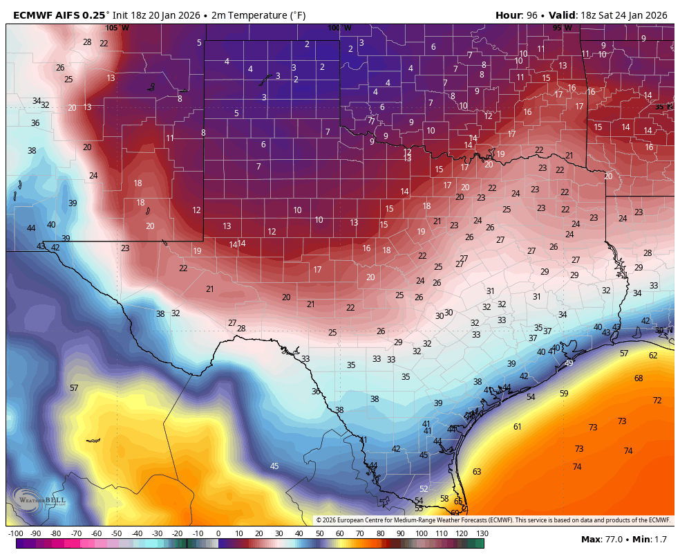
Like the Euro AI better than the Op in terms of progression of cold but if you've got single digits up in Lubbock noon and teens in San Angelo Saturday it's going to be even colder further south than even modeled here. Btw can you spot the "shadow effect"
4 likes
Re: Texas Winter 2025-2026
Tireman4 wrote:Gotwood wrote:orangeblood wrote:Model algos are going to have fits trying to decipher these precip types. Overall GFS is probably best at this range to handle surface depictions until we get into high res range later tomorrow. It currently has 0.10” frz rain, 5” sleet and almost 3 inches of snow at DFW…that would cause a major shutdown across the metroplex and seems like the most sensible solution with a 3:1 sleet ratio .
Austin to Houston is a really tough forecast
https://images.weatherbell.com/meteogram/gfs-deterministic/KDFW/winter_summary/1768932000/1768932000-68TRGzs6imo.png
5 inches of sleet? I’m not sure my mind can comprehend that lol.
I have seen 12 inches of sleet in February 1987 in Raleigh, North Carolina. It started at 10 am and ended at midnight. It was something
Good lord I couldn’t imagine
1 likes
-
rwfromkansas
- Category 5
- Posts: 3028
- Joined: Sat Aug 27, 2005 12:47 am
- Location: North Fort Worth
Re: Texas Winter 2025-2026
orangeblood wrote:Model algos are going to have fits trying to decipher these precip types. Overall GFS is probably best at this range to handle surface depictions until we get into high res range later tomorrow. It currently has 0.10” frz rain, 5” sleet and almost 3 inches of snow at DFW…that would cause a major shutdown across the metroplex and seems like the most sensible solution with a 3:1 sleet ratio .
Austin to Houston is a really tough forecast
https://images.weatherbell.com/meteogram/gfs-deterministic/KDFW/winter_summary/1768932000/1768932000-68TRGzs6imo.png
I would take 8 inches of white stuff as long as a couple inches of that is snow. That sounds good. Compressed down a bit due to the sleet, but still nice to look at.
3 likes
-
orangeblood
- S2K Supporter
- Posts: 3895
- Joined: Tue Dec 15, 2009 6:14 pm
- Location: Fort Worth, TX
Re: Texas Winter 2025-2026
Major concern increasing from several pro mets now of a 2021 style redux across North Texas (less duration but more high impact frz precip), this is the real deal and start prepping now
[xpost] https://x.com/ntexasweather/status/2013 ... 02852?s=46[/xpost]
[xpost] https://x.com/ntexasweather/status/2013 ... 02852?s=46[/xpost]
4 likes
Who is online
Users browsing this forum: No registered users and 54 guests