
Stratton23 wrote:I know the focus is on this system, but the GFS/ CMC are already seeing yet another shortwave diving down around the 30th and producing more wintry precipitation with cold air still in place
The AI-GFS as well.
Moderator: S2k Moderators
 The posts in this forum are NOT official forecast and should not be used as such. They are just the opinion of the poster and may or may not be backed by sound meteorological data. They are NOT endorsed by any professional institution or STORM2K.
Stratton23 wrote:I know the focus is on this system, but the GFS/ CMC are already seeing yet another shortwave diving down around the 30th and producing more wintry precipitation with cold air still in place
txtwister78 wrote:Quixotic wrote:Texas Snow wrote:I was confused by that as I read it was flying tomorrow so thanks. Was hoping to wake up to newly modeled data however. Oh well, another day of speculation is entertainment
So, here’s my question: front comes in on Friday. Precip is supposed to start right after. Will FWD do a sounding like they did last year? Can they with precip falling, northerly low level flow and southwesterly/southern flow at the mid to upper levels? I mean it would definitely clear up the precip type.
The short range high resolution models will be able to define that better as mentioned earlier. Right now CMC and GFS keep this sleet for DFW metro with a changeover depicted at the end on the GFS. CMC is basically one hell of a sleet storm. Euro obviously a bit more amped so you're looking at freezing rain/sleet mix. Still a day of globals but by Thursday everyone including that office will start turning their attention to the models that should have a better handle on precip types/amounts.
WaveBreaking wrote:Quixotic wrote:gpsnowman wrote:Winter Storm Fern. Ha!
They tried “Begonia” but nobody could pronounce it.
This is exactly why I don’t like the Weather Channel naming winter storms (among other reasons). Instead of following the NHC’s philosophy of having simple and easy-to-pronounce names for their hurricanes, the Weather Channel decides to fill their annual lists with tacky/pretentious names that you know damn well the average layperson has never heard of and probably can’t pronounce. Like when’s the last time you’ve heard of someone named “Freyr” or “Gorgon”?
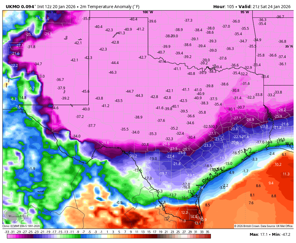
Quixotic wrote:snownado wrote:00z UKMET is...uh...interesting....
Do tell.

snownado wrote:00z UKMET is...uh...interesting....


Quixotic wrote:txtwister78 wrote:Quixotic wrote:
So, here’s my question: front comes in on Friday. Precip is supposed to start right after. Will FWD do a sounding like they did last year? Can they with precip falling, northerly low level flow and southwesterly/southern flow at the mid to upper levels? I mean it would definitely clear up the precip type.
The short range high resolution models will be able to define that better as mentioned earlier. Right now CMC and GFS keep this sleet for DFW metro with a changeover depicted at the end on the GFS. CMC is basically one hell of a sleet storm. Euro obviously a bit more amped so you're looking at freezing rain/sleet mix. Still a day of globals but by Thursday everyone including that office will start turning their attention to the models that should have a better handle on precip types/amounts.
I understand. So, last year when we watched something similar all week, the day before they did a sounding. It was in range of the HR models. After that my point forecast turned into a rain/snow mix. Granted the cold air had been in place under sunny skies for a couple of days. They got it right for most of the area but from MBY on north and northeast the storm did pretty well. Just curious if they’d bother with the conditions changing so quickly.
Stratton23 wrote:Yeah you can toss the UKMET in the trash, that aint happening chief, not a chance
txtwister78 wrote:Quixotic wrote:txtwister78 wrote:
The short range high resolution models will be able to define that better as mentioned earlier. Right now CMC and GFS keep this sleet for DFW metro with a changeover depicted at the end on the GFS. CMC is basically one hell of a sleet storm. Euro obviously a bit more amped so you're looking at freezing rain/sleet mix. Still a day of globals but by Thursday everyone including that office will start turning their attention to the models that should have a better handle on precip types/amounts.
I understand. So, last year when we watched something similar all week, the day before they did a sounding. It was in range of the HR models. After that my point forecast turned into a rain/snow mix. Granted the cold air had been in place under sunny skies for a couple of days. They got it right for most of the area but from MBY on north and northeast the storm did pretty well. Just curious if they’d bother with the conditions changing so quickly.
Last year you didn't have the type of arctic airmass we're anticipating here so with a stronger arctic high that pushes further south that may be enough to put you guys into a changeover faster. I still think that's in the cards but I'm not saying they won't do a sounding. I think when you're dealing/relying more on an upper level feature alone to do the trick that's where things get more complicated and it's a much harder call when you have that sw flow to contend with and they knew that then which is probably why they did the sounding to verify.

Stratton23 wrote:Yeah you can toss the UKMET in the trash, that aint happening chief, not a chance
snownado wrote:To the UKMET's credit, the upper levels don't lie...
[url]https://i.ibb.co/Q2PK3fC/Screenshot-2026-01-20-231910.png [/url]
Stratton23 wrote:Yeah you can toss the UKMET in the trash, that aint happening chief, not a chance
Users browsing this forum: No registered users and 32 guests


