Texas Winter 2025-2026
Moderator: S2k Moderators
Forum rules
 The posts in this forum are NOT official forecast and should not be used as such. They are just the opinion of the poster and may or may not be backed by sound meteorological data. They are NOT endorsed by any professional institution or STORM2K.

The posts in this forum are NOT official forecast and should not be used as such. They are just the opinion of the poster and may or may not be backed by sound meteorological data. They are NOT endorsed by any professional institution or STORM2K.
-
bubba hotep

- S2K Supporter

- Posts: 6013
- Joined: Wed Dec 28, 2016 1:00 am
- Location: Collin County Texas
Re: Texas Winter 2025-2026
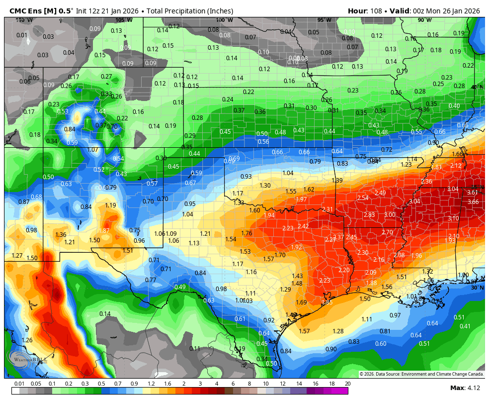
Word of caution - don't hang your hat on today's bullseye
7 likes
Winter time post are almost exclusively focused on the DFW area.
-
Tireman4

- S2K Supporter
- Posts: 5903
- Age: 60
- Joined: Fri Jun 30, 2006 1:08 pm
- Location: Humble, Texas
- Contact:
Re: Texas Winter 2025-2026
bubba hotep wrote:Word of caution - don't hang your hat on today's bullseye
Agreed, this is an ever moving target.
2 likes
-
Edwards Limestone

- S2K Supporter
- Posts: 509
- Age: 36
- Joined: Tue Dec 28, 2021 11:05 am
- Location: Smithson Valley, TX
Re: Texas Winter 2025-2026
EWX has this clearing out of my area early Sunday morning. Cold temps, yes. But nothing even comparable to 2021 (thank goodness).
Good luck to the NTX/Oklahoma posters.
Good luck to the NTX/Oklahoma posters.
0 likes
The above post is NOT an official forecast and should not be used as such. It is just the opinion of the poster and may or may not be backed by sound meteorological data. It is NOT endorsed by any professional institution including Storm2k. For official information, please refer to NWS products.
Re: Texas Winter 2025-2026
Stratton23 wrote:And the Euro/ Euro AIFS runs are delayed, shocker lol
It's running now...
0 likes
-
txtwister78

- Category 5

- Posts: 2169
- Joined: Wed Jan 30, 2019 12:56 pm
- Location: San Antonio
Re: Texas Winter 2025-2026
Edwards Limestone wrote:EWX has this clearing out of my area early Sunday morning. Cold temps, yes. But nothing even comparable to 2021 (thank goodness).
Good luck to the NTX/Oklahoma posters.
It never was going to be. Still ice/sleet threat down across this region beginning Saturday afternoon into early Sunday morning with brutal wind chills.
Last edited by txtwister78 on Wed Jan 21, 2026 12:56 pm, edited 1 time in total.
2 likes
-
Lagreeneyes03
- Category 2

- Posts: 610
- Joined: Mon Dec 09, 2013 10:53 am
- Location: Luxurious Lake Grapevine
Re: Texas Winter 2025-2026
Based on one Euro run, Twitter/X has all but ruled out anything but rain for Texas lol. That's how I know we will get sleet/snow
2 likes
I'm a Princess, not a forecaster.

Re: Texas Winter 2025-2026
FWIW, Austin Energy has trucks positioned in and around downtown, glad they are prepared just in case.
0 likes
Resident Rain Miser
I am a weather hobbyist living 3.5 miles south of Downtown Austin and in no way or fashion should anything I say concerning forecasts be taken seriously. Please check your local NWS for accurate weather forecasting and conditions.
I am a weather hobbyist living 3.5 miles south of Downtown Austin and in no way or fashion should anything I say concerning forecasts be taken seriously. Please check your local NWS for accurate weather forecasting and conditions.
-
TheAustinMan

- Category 5
- Posts: 1060
- Joined: Mon Jul 08, 2013 4:26 pm
- Location: Central TX / United States
Re: Texas Winter 2025-2026
When checking up on the ensembles yesterday, the general impression was that stronger ridging today over the Pacific NW coast was correlated with a slightly slower southwest trough this weekend, though the signal was somewhat fuzzy. The trend was slight, but the GEFS did trend towards slightly higher heights over that region, which led to our trough of interest shifting south on the ensemble mean (looks like it's gone towards the EPS, which has generally kept the same tune for that time range). Consistent with the earlier correlation analysis, the GEFS mean has trended slower and more amplified with the southwestern trough.
This has some possible consequences for the weekend event. More amplified troughing could drive up a more stout warm nose at the start of the event (see for example, the trend north in the GEFS 850mb temperature anomalies for Saturday evening), but the slower troughing could prolong the event and precipitation occurrence as a whole (note the the westward shifts in QPF through Sunday morning). As an example, the latest deterministic GFS suggests the possibility of two-ish distinct precipitation episodes... the first powered by frontogenesis and isentropic lift after the front first arrives, and then the second when the potentially phased southern trough and northern trough over the Intermountain West surge over the area with divergent flow aloft).
We are now getting into the fuzzy range where our key player in this event, the southwestern trough, starts to shape its own destiny as seen in the below figure, which highlights that the impact of the broader synoptic pattern at this range outside of the trough itself is becoming less helpful for prediction. This is why that recon flight later today, sampling the trough itself, is going to be quite useful.
As we start to settle onto a synoptic pattern for the event, the mesoscale factors and the behavior of the shallow cold airmass in the lowest few thousand feet of the atmosphere is going to make or break what ultimately comes of all this. On that note, the cold airmass is still up there in northern Canada, so I wouldn't put too much stock in low-level temperatures from mesoscale models until it actually starts to surge south across the Plains on Friday. Even then, mesoscales still have their issues with complicated boundary layer physics near the surface, and perhaps doubly so when there's precipitation involved.
14 likes
Treat my opinions with a grain of salt. For official information see your local weather service.
“It's tough to make predictions, especially about the future.”
“It's tough to make predictions, especially about the future.”
-
orangeblood
- S2K Supporter
- Posts: 3895
- Joined: Tue Dec 15, 2009 6:14 pm
- Location: Fort Worth, TX
Re: Texas Winter 2025-2026
bubba hotep wrote:Word of caution - don't hang your hat on today's bullseye
At this range, don't think it's too risky IMHO....starting to see consolidation with the precip shield happening on the Ens Mean. ULL trowel formation seems to be forming directly thru North Texas

5 likes
-
ThunderSleetDreams

- S2K Supporter
- Posts: 1510
- Age: 43
- Joined: Tue Dec 20, 2011 4:42 pm
- Location: S of Weimar, TX
Re: Texas Winter 2025-2026
TheAustinMan wrote:When checking up on the ensembles yesterday, the general impression was that stronger ridging today over the Pacific NW coast was correlated with a slightly slower southwest trough this weekend, though the signal was somewhat fuzzy. The trend was slight, but the GEFS did trend towards slightly higher heights over that region, which led to our trough of interest shifting south on the ensemble mean (looks like it's gone towards the EPS, which has generally kept the same tune for that time range). Consistent with the earlier correlation analysis, the GEFS mean has trended slower and more amplified with the southwestern trough.
This has some possible consequences for the weekend event. More amplified troughing could drive up a more stout warm nose at the start of the event (see for example, the trend north in the GEFS 850mb temperature anomalies for Saturday evening), but the slower troughing could prolong the event and precipitation occurrence as a whole (note the the westward shifts in QPF through Sunday morning). As an example, the latest deterministic GFS suggests the possibility of two-ish distinct precipitation episodes... the first powered by frontogenesis and isentropic lift after the front first arrives, and then the second when the potentially phased southern trough and northern trough over the Intermountain West surge over the area with divergent flow aloft).
We are now getting into the fuzzy range where our key player in this event, the southwestern trough, starts to shape its own destiny as seen in the below figure, which highlights that the impact of the broader synoptic pattern at this range outside of the trough itself is becoming less helpful for prediction. This is why that recon flight later today, sampling the trough itself, is going to be quite useful.
As we start to settle onto a synoptic pattern for the event, the mesoscale factors and the behavior of the shallow cold airmass in the lowest few thousand feet of the atmosphere is going to make or break what ultimately comes of all this. On that note, the cold airmass is still up there in northern Canada, so I wouldn't put too much stock in low-level temperatures from mesoscale models until it actually starts to surge south across the Plains on Friday. Even then, mesoscales still have their issues with complicated boundary layer physics near the surface, and perhaps doubly so when there's precipitation involved.
https://i.imgur.com/Wzo8ZJ7.png
You are a treasure to this board! I’ve never perused sensitivity plots, but now I’m learning.
Thank you!
6 likes
#NeverSummer
I hibernate when it gets above 75 degrees!
I hibernate when it gets above 75 degrees!
Re: Texas Winter 2025-2026
Have the day off finishing the last of the leaf work sipping an afternoon beer wondering how my brain can handle two more days of weather watching. It's been done before no doubt. Still think a sleet to snow change over is in the cards for DFW with minimal freezing rain. And a lot of it. We will see. Just my .1¢
5 likes


-
orangeblood
- S2K Supporter
- Posts: 3895
- Joined: Tue Dec 15, 2009 6:14 pm
- Location: Fort Worth, TX
Re: Texas Winter 2025-2026
wxman22 wrote:12Z Euro, also has some snow on the backside.
https://i.ibb.co/3YrRV9nf/9-km-ECMWF-USA-Cities-Texas-Precip-Type-MSLP-3.gif
Yep, Rain>Frz Rain>Sleet>Snow transition....FW and Norman NWS seems to have a good handle on this setup
4 likes
-
HockeyTx82
- S2K Supporter
- Posts: 2790
- Joined: Tue Oct 27, 2009 11:17 am
- Location: Ponder, TX
Re: Texas Winter 2025-2026
orangeblood wrote:wxman22 wrote:12Z Euro, also has some snow on the backside.
https://i.ibb.co/3YrRV9nf/9-km-ECMWF-USA-Cities-Texas-Precip-Type-MSLP-3.gif
Yep, Rain>Frz Rain>Sleet>Snow transition....FW and Norman NWS seems to have a good handle on this setup
OK, lock the thread, no more discussion
3 likes
Don't hold me accountable for anything I post on this forum. Leave the real forecasting up to the professionals.
Location: Ponder, TX (all observation posts are this location unless otherwise noted)
Location: Ponder, TX (all observation posts are this location unless otherwise noted)


Re: Texas Winter 2025-2026
wxman22 wrote:12Z Euro, also has some snow on the backside.
https://i.ibb.co/3YrRV9nf/9-km-ECMWF-USA-Cities-Texas-Precip-Type-MSLP-3.gif
Lets get those south digging trends in the baja!
8 likes
The above post and any post by Ntxw is NOT an official forecast and should not be used as such. It is just the opinion of the poster and may or may not be backed by sound meteorological data. It is NOT endorsed by any professional institution including Storm2k. For official information, please refer to NWS products.
Help support Storm2K!
-
wxman57

- Moderator-Pro Met

- Posts: 23172
- Age: 68
- Joined: Sat Jun 21, 2003 8:06 pm
- Location: Houston, TX (southwest)
Re: Texas Winter 2025-2026
12Z EC looks WAY too warm and slow with the front. It had Houston at 71 degrees 6pm Saturday and no freezing rain south of College Station. Ignore it. Meanwhile, crazy Canadian has Houston down to 3 degrees Tuesday morning, which is over 20 degrees colder than NBM. Ignore it, at least for Houston. As for me, I'm hoping the EC is right and that the front won't do much for the Houston area. Unfortunately, I think it's not doing well at all.
7 likes
-
rwfromkansas
- Category 5
- Posts: 3028
- Joined: Sat Aug 27, 2005 12:47 am
- Location: North Fort Worth
Re: Texas Winter 2025-2026
This is the part of the storm that I hate, too. Just the waiting.
Earlier the what if is exciting and not real life yet since it’s early.
Earlier the what if is exciting and not real life yet since it’s early.
2 likes
-
HockeyTx82
- S2K Supporter
- Posts: 2790
- Joined: Tue Oct 27, 2009 11:17 am
- Location: Ponder, TX
Re: Texas Winter 2025-2026
rwfromkansas wrote:This is the part of the storm that I hate, too. Just the waiting.
Earlier the what if is exciting and not real life yet since it’s early.
I'm taking a lunch walk right now on the UNT Campus. It's absolutely gorgeous out today, hard to think in a few days it could be buried and ice/snow and down in the single digits.....
6 likes
Don't hold me accountable for anything I post on this forum. Leave the real forecasting up to the professionals.
Location: Ponder, TX (all observation posts are this location unless otherwise noted)
Location: Ponder, TX (all observation posts are this location unless otherwise noted)
-
orangeblood
- S2K Supporter
- Posts: 3895
- Joined: Tue Dec 15, 2009 6:14 pm
- Location: Fort Worth, TX
Re: Texas Winter 2025-2026
wxman57 wrote:12Z EC looks WAY too warm and slow with the front. It had Houston at 71 degrees 6pm Saturday and no freezing rain south of College Station. Ignore it. Meanwhile, crazy Canadian has Houston down to 3 degrees Tuesday morning, which is over 20 degrees colder than NBM. Ignore it, at least for Houston. As for me, I'm hoping the EC is right and that the front won't do much for the Houston area. Unfortunately, I think it's not doing well at all.
Truly mind blowing how bad the Euro can be with surface low level dense cold vs upper levels. But then again, every model has it's strengths and weaknesses
3 likes
-
HockeyTx82
- S2K Supporter
- Posts: 2790
- Joined: Tue Oct 27, 2009 11:17 am
- Location: Ponder, TX
Re: Texas Winter 2025-2026
https://forecast.weather.gov/wwamap/wwa ... ld%20watch
Extreme Cold Watch for DFW.
Also, my grid forecast for them now shows 100% chance of precipitation on Saturday.
I don't have a recall seeing that this far out from them.
Extreme Cold Watch for DFW.
Also, my grid forecast for them now shows 100% chance of precipitation on Saturday.
I don't have a recall seeing that this far out from them.
Last edited by HockeyTx82 on Wed Jan 21, 2026 1:47 pm, edited 1 time in total.
1 likes
Don't hold me accountable for anything I post on this forum. Leave the real forecasting up to the professionals.
Location: Ponder, TX (all observation posts are this location unless otherwise noted)
Location: Ponder, TX (all observation posts are this location unless otherwise noted)
Who is online
Users browsing this forum: No registered users and 50 guests