Texas Winter 2025-2026

Winter Weather Discussion

Moderator: S2k Moderators

Forum rules

The posts in this forum are NOT official forecast and should not be used as such. They are just the opinion of the poster and may or may not be backed by sound meteorological data. They are NOT endorsed by any professional institution or STORM2K.

Help Support Storm2K
Message
Author
Snowman67
Category 2
Category 2
Posts: 641
Joined: Thu Dec 31, 2009 12:44 pm
Location: Tomball, TX

Re: Texas Winter 2025-2026

#3461 Postby Snowman67 » Wed Jan 21, 2026 3:30 pm

wxman57 wrote:
Portastorm wrote:
CaptinCrunch wrote:
I got called into a meeting this morning at 8am to go over out EMS text msgs system to ensure it was up to date with staff information. Good times :lol:


Right there with you! I’m officially “on call” for this weekend.


I'm not only "on call", I'm "on" for the weekend. I've had only 2 days off since Dec. 29th. Was working a long duration project until last Friday and now I'm in winter weather mode coverage. I'll have more comp days this January than I had all last hurricane season.

I'm not worried at all about power outages, though, as my new whole-house generator is ready and waiting. I think we'll just see a glazing of bridges and overpasses here in Houston. North parts of the county could have enough freezing rain to cause some power issues.


I'm a little more worried about trees/power up here on the Harris/Montgomery County line, but about 1/3 of my subdivision (including me) are on a hospital grid. In hurricane IKE I was only without power for less than 12 hours while many in the neighborhood were out for two weeks.
0 likes   
Any forecast I make is based on my opinion only. Please refer to the NWS or NHC for official forecasts.

HockeyTx82
S2K Supporter
S2K Supporter
Posts: 2699
Joined: Tue Oct 27, 2009 11:17 am
Location: Ponder, TX

Re: Texas Winter 2025-2026

#3462 Postby HockeyTx82 » Wed Jan 21, 2026 3:31 pm

My MSN weather app has the temps warmer now, still below freezing but upper 20's on Saturday.
0 likes   
Don't hold me accountable for anything I post on this forum. Leave the real forecasting up to the professionals.

Location: Ponder, TX (all observation posts are this location unless otherwise noted)

User avatar
txtwister78
Category 5
Category 5
Posts: 2058
Joined: Wed Jan 30, 2019 12:56 pm
Location: San Antonio

Re: Texas Winter 2025-2026

#3463 Postby txtwister78 » Wed Jan 21, 2026 3:35 pm

NAM starting to catch up on the progression/arrival of cold drilling down into the state, 18z vs 12z Friday evening. Big shift especially for folks further south.

Image

Image
5 likes   

User avatar
Texas Snow
S2K Supporter
S2K Supporter
Posts: 799
Joined: Mon Oct 19, 2015 12:06 pm
Location: N. Dallas & Cedar Creek Lake

Re: Texas Winter 2025-2026

#3464 Postby Texas Snow » Wed Jan 21, 2026 3:35 pm

HockeyTx82 wrote:My MSN weather app has the temps warmer now, still below freezing but upper 20's on Saturday.


NWS has a high of 23 for you
0 likes   
"Don't let wishcastin get in the way of your forecastin"

Image

User avatar
Ntxw
Storm2k Moderator
Storm2k Moderator
Posts: 23296
Joined: Wed Oct 21, 2009 6:34 pm
Location: DFW, Texas

Re: Texas Winter 2025-2026

#3465 Postby Ntxw » Wed Jan 21, 2026 3:37 pm

I'm still curious on the Euro's freezing rain depictions, model? Site algorithm? Most of the other guidance is a sleet-fest at the onset mostly. Good test subject.
2 likes   
The above post and any post by Ntxw is NOT an official forecast and should not be used as such. It is just the opinion of the poster and may or may not be backed by sound meteorological data. It is NOT endorsed by any professional institution including Storm2k. For official information, please refer to NWS products.

  Help support Storm2K!
Help Support Storm2K

User avatar
Tireman4
S2K Supporter
S2K Supporter
Posts: 5894
Age: 60
Joined: Fri Jun 30, 2006 1:08 pm
Location: Humble, Texas
Contact:

Re: Texas Winter 2025-2026

#3466 Postby Tireman4 » Wed Jan 21, 2026 3:38 pm

770
FXUS64 KHGX 212024
AFDHGX

Area Forecast Discussion
National Weather Service Houston/Galveston TX
224 PM CST Wed Jan 21 2026

...New DISCUSSION, MARINE...

.KEY MESSAGES...

- Areas of dense fog may develop tonight into tomorrow morning.

- An Arctic front pushes through Friday night/Saturday, bringing
various winter hazards over the weekend:
- Extended periods of below freezing temperatures along with
hard freezes for parts of the area Saturday night, Sunday
night, and Monday night.
- Low wind chill values, potentially near 0 in northwestern
areas.
- Freezing Rain with hazardous to significant ice accumulations.
- Hazardous marine conditions.

- Residents are encouraged to winterize their home and make plans
to keep themselves and loved ones warm during the work week
prior to the arrival of the Arctic air.

&&

.DISCUSSION...
Issued at 224 PM CST Wed Jan 21 2026

Today through Thursday:

Light to moderate rain continues to move eastward across the area,
with a low chance of a thunderstorm if anything can get going behind
the main area of rain. With a front stalled across the area, a more
humid air mass than we have had recently, and weak onshore flow
southeast of the front, guidance is trending more aggressive with
dense fog development tonight. A dense fog advisory may need to be
issued tonight if trends continue. A warm day is expected on
Thursday with very low rain chances, which will be good conditions
to prepare for the incoming Arctic cold outbreak and winter
storm.

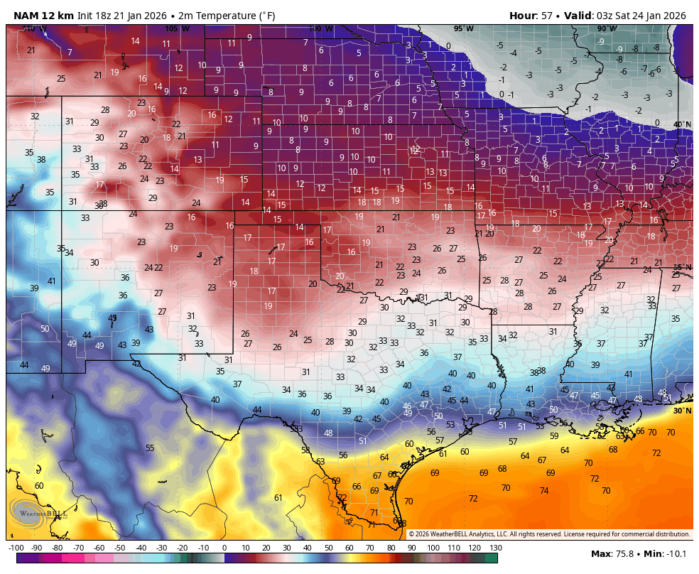
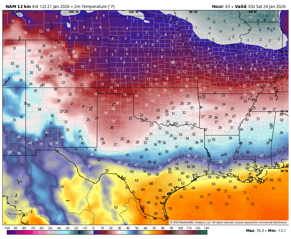
Friday through Monday:

Confidence continues to increase in dangerously cold temperatures
and wind chills coming into the area this weekend and into early
next week. Confidence also continues to increase in a significant
icing event for the Piney Woods and Brazos Valley. The southern
extent of the freezing rain along and south of the I-10 corridor
remains more uncertain, but potentially highly impactful. This is
due to the very cold temperatures moving in and the potential for
significant travel impacts with even small amounts of freezing
rain especially on elevated surface/highway overpasses. Areas that
do not drop below freezing until precipitation ends can still see
impacts as any moisture remaining moisture on roadways/bridges
may re-freeze. Winds will also increase the impacts of freezing
precipitation.

While the wintry precipitation has certainly attracted a lot of
attention, we want to make sure that the dangerously cold weather
coming in does not get overshadowed. Hard freeze conditions will be
possible both Saturday night and Sunday night with lows in the teens
and lower 20s, lowest on Sunday night into Monday morning.
Additionally, gusty northerly winds will be present, dropping wind
chills into the single digits and teens both nights, again lowest
Sunday night into Monday morning. We have issued an areawide Extreme
Cold Watch to account for both the wind chill and hard freeze
threats, rather than issuing a separate Freeze Watch/Warning for
a hard freeze. Similarly cold temperatures will continue Monday
night into Tuesday morning. However, with lower winds, apparent
temperatures may be more in the range of a Cold Weather Advisory
than an Extreme Cold Warning, so we will not continue the watch
that far out at this time. Also of note, many areas north of I-10
may not get above freezing all day on Sunday.

A notable change from earlier guidance regarding the synoptic
pattern is that guidance has trended more progressive with the
cutoff low off the coast of the Baja, now showing it phasing more
with the northern stream trough and becoming a more progressive
shortwave. It appears this may be one of the reasons for the large
model spread in temperatures for the area Saturday into early
Sunday, as the increased forcing may allow a bit more of a surface
trough or wave of low pressure to develop along the Gulf Coast.
This increased onshore flow and coastal front would offer a bit
more resistance to the strong shallow Arctic air mass moving in,
though it will eventually give in. Until we get closer in time to
see which will win out for areas along and south of I-10, we will
continue to lean heavily into probabilistic messaging and urge
everyone to continue to check the latest forecasts. Will note that
there is even a lower probability alternative scenario where a
small warm sector develops right along the coast with a potential
for severe storms Saturday, but this probability is too low for
any official messaging at this time.

The latest probabilistic WSSI from WPC continues to hit hard on the
freezing rain impacts for the Brazos Valley and Piney Woods. NBM
continues to show medium chances of significant ice accumulations
exceeding 0.25" in northern portions of the areas, indicating an
increasing concern for power outages, with impacts compounded by the
very cold air moving in behind this system and gusty northerly
winds. Rain may change over to freezing rain as early as early
Saturday morning in areas such as Houston County, with the surface
freezing line beginning to progress southward through the day.
Some minor sleet accumulations may also occur in our far northern
counties. For areas along and south of I- 10, we will have to
watch the surface freezing line closely Saturday night to Sunday
morning, relative to when waves of precipitation move through.
20-30% NBM probabilities of 1/8" of ice (winter storm warning
criteria) extend down into the I-10 corridor, along with 30- 60%
probabilities of 0.01". 20% probabilities of 0.01" of ice extend
down to the coast. A Winter Storm Watch has been issued for areas
generally along and north of I-10, and will monitor for any need
to expand it southward. As we get closer, upgrades to a Winter
Storm Warning (or an Ice Storm Warning further north) are possible
as well as Winter Weather Advisories, which may extend further
south of the current watch area. Remember that even going from a
Winter Storm Watch to a Winter Weather Advisory is an upgrade, not
a downgrade, as it indicates increasing confidence in impacts.
This is especially the case when it comes to freezing rain, since
even small amounts can have a big impact.

JDavis

&&

.AVIATION...
(12Z TAF Issuance)
Issued at 542 AM CST Wed Jan 21 2026

MVFR/IFR CIGs moving in with the rain band that is currently
draped from SW to NE across the Brazos Valley and Piney Woods.
Expect this band to continue a SE progression through the day. At
the same time, have some showers moving north from South Texas
this morning, impacting areas along and south of I-10. These are
producing mostly drizzle compared to the showers north of the
metro. Timing of arrival of northern band of showers looks to be a
bit quicker than originally forecast. Currently looking at IAH
experiencing SHRA as early as 13Z. Expect SHRA to continue through
the duration of the day, and tapering off shortly after sunset.
CIGs and VSBYs anticipated to deteriorate overnight through
Thursday morning to MVFR/IFR levels. Fog may become dense at
time, and may reach LIFR levels.

&&

.MARINE...
Issued at 224 PM CST Wed Jan 21 2026

A coastal trough will lead to rain continuing through tonight,
with low chances continuing into Thursday afternoon. An isolated
storm or two cannot be ruled out, especially this afternoon.
Water temperatures in the bays and along the immediate coast range
from the upper 50s to low 60s. Southeasterly winds will gradually
increase dew points into the low to mid 60s by this afternoon.
This leads to the potential for sea fog tonight and Thursday
night. This fog may be locally dense at times, especially
tonight into Thursday morning.

A strong Arctic cold front pushes offshore by Saturday with
strong northeasterly to northerly winds prevailing in its wake
through the weekend. Small Craft Advisories will be needed for
this period with sustained winds in the 25-30 kt range and
elevated seas in the 8-11 ft range. Gale force gusts cannot be
ruled out. Widespread precipitation is expected late Friday into
Sunday behind the front. While the precipitation type along the
immediate coast is anticipated to be liquid, there are some areas
along the northern and central portions of the bays that have the
potential for freezing rain Saturday night into Sunday morning.
Additionally, we`ll monitor for the potential for another round of
abnormally low water levels in the bays during low tide cycles,
so be sure to stay up to date with the latest forecasts.

&&

.PRELIMINARY POINT TEMPS/POPS...
College Station (CLL) 54 71 59 70 / 20 0 10 60
Houston (IAH) 60 74 61 73 / 30 10 10 40
Galveston (GLS) 60 67 60 67 / 30 10 10 40

&&

.HGX WATCHES/WARNINGS/ADVISORIES...
TX...Winter Storm Watch from Saturday morning through Sunday
afternoon for TXZ163-164-176>179-195>200-210>214-226-227-
300-313.

Extreme Cold Watch from Saturday evening through Monday morning
for TXZ163-164-176>179-195>200-210>214-226-227-235>238-300-
313-335>338-436>439.

GM...None.
&&

$$

DISCUSSION...JDavis
AVIATION...Bailey
MARINE...JDavis
0 likes   

HockeyTx82
S2K Supporter
S2K Supporter
Posts: 2699
Joined: Tue Oct 27, 2009 11:17 am
Location: Ponder, TX

Re: Texas Winter 2025-2026

#3467 Postby HockeyTx82 » Wed Jan 21, 2026 3:38 pm

Texas Snow wrote:
HockeyTx82 wrote:My MSN weather app has the temps warmer now, still below freezing but upper 20's on Saturday.


NWS has a high of 23 for you


You trust the Government???? :D

Kidding, lol. I know weather apps are fools errand, just making an observation.
1 likes   
Don't hold me accountable for anything I post on this forum. Leave the real forecasting up to the professionals.

Location: Ponder, TX (all observation posts are this location unless otherwise noted)

User avatar
Iceresistance
Category 5
Category 5
Posts: 9491
Age: 22
Joined: Sat Oct 10, 2020 9:45 am
Location: Tecumseh, OK/Norman, OK

Re: Texas Winter 2025-2026

#3468 Postby Iceresistance » Wed Jan 21, 2026 3:44 pm

NAM just made a big jump south
Image
https://s12.gifyu.com/images/bkK53.gif
7 likes   
Bill 2015 & Beta 2020

Winter 2020-2021 :cold:

All observations are in Tecumseh, OK unless otherwise noted.

Winter posts are focused mainly for Oklahoma & Texas.

Take any of my forecasts with a grain of salt, refer to the NWS, SPC, and NHC for official information

Never say Never with weather! Because ANYTHING is possible!

User avatar
Tammie
S2K Supporter
S2K Supporter
Posts: 331
Joined: Thu Dec 05, 2013 7:49 am
Location: Sherman, TX

Re: Texas Winter 2025-2026

#3469 Postby Tammie » Wed Jan 21, 2026 3:55 pm

Iceresistance wrote:NAM just made a big jump south
https://s12.gifyu.com/images/bkK53.gif


What does that mean for north Texas? Sherman was in the sweet spot for days, now I’m not even sure if we’ll get more than cold rain LOL! Too many ensembles for my brain to keep up with.
0 likes   
Tammie - Sherman TX

gpsnowman
S2K Supporter
S2K Supporter
Posts: 3287
Joined: Fri Jan 07, 2011 10:35 am
Location: Grand Prairie Tx

Re: Texas Winter 2025-2026

#3470 Postby gpsnowman » Wed Jan 21, 2026 3:56 pm

My wife thinks I am crazy every winter until she experiences winter. Then I am right, temporarily of course.
1 likes   

orangeblood
S2K Supporter
S2K Supporter
Posts: 3810
Joined: Tue Dec 15, 2009 6:14 pm
Location: Fort Worth, TX

Re: Texas Winter 2025-2026

#3471 Postby orangeblood » Wed Jan 21, 2026 3:56 pm

Tammie wrote:
Iceresistance wrote:NAM just made a big jump south
https://s12.gifyu.com/images/bkK53.gif


What does that mean for north Texas? Sherman was in the sweet spot for days, now I’m not even sure if we’ll get more than cold rain LOL! Too many ensembles for my brain to keep up with.


Massive sleet storm …wide spread 5-9” of sleet across almost the entire area

Also, frz line makes it quicker into a lot of the area before precip begins. Thats key to increase totals
Last edited by orangeblood on Wed Jan 21, 2026 3:58 pm, edited 1 time in total.
4 likes   

User avatar
wxman22
Category 5
Category 5
Posts: 1769
Joined: Mon Jan 30, 2006 12:39 am
Location: Wichita Falls, TX
Contact:

Re: Texas Winter 2025-2026

#3472 Postby wxman22 » Wed Jan 21, 2026 3:57 pm

We’re getting in range of the 3k NAM. I can’t wait to see the RAP,HRRR,and WRF models once in range.

Image
Last edited by wxman22 on Wed Jan 21, 2026 3:58 pm, edited 1 time in total.
3 likes   

User avatar
txtwister78
Category 5
Category 5
Posts: 2058
Joined: Wed Jan 30, 2019 12:56 pm
Location: San Antonio

Re: Texas Winter 2025-2026

#3473 Postby txtwister78 » Wed Jan 21, 2026 3:58 pm

Tammie wrote:
Iceresistance wrote:NAM just made a big jump south
https://s12.gifyu.com/images/bkK53.gif


What does that mean for north Texas? Sherman was in the sweet spot for days, now I’m not even sure if we’ll get more than cold rain LOL! Too many ensembles for my brain to keep up with.


Could end up being a longer duration of ice/sleet as models play catch up to the surface temps being colder sooner than what globals have.
2 likes   

rwfromkansas
Category 5
Category 5
Posts: 2877
Joined: Sat Aug 27, 2005 12:47 am
Location: North Fort Worth

Re: Texas Winter 2025-2026

#3474 Postby rwfromkansas » Wed Jan 21, 2026 4:02 pm

Iceresistance wrote:NAM just made a big jump south
https://s12.gifyu.com/images/bkK53.gif


I notice the colder temps up north have warmed a bit, but the below freezing line is further south. I would like to see even colder temps up north to maybe be an imaginary sign of cooling, but it is a trend for more sleet for DFW....over just one run though, so not worth getting too excited. If it's going to mostly be freezing rain it might as well be a cold rain for infrastructure concerns. Sleet doesn't stick to power lines, just roads.
0 likes   

User avatar
Tammie
S2K Supporter
S2K Supporter
Posts: 331
Joined: Thu Dec 05, 2013 7:49 am
Location: Sherman, TX

Re: Texas Winter 2025-2026

#3475 Postby Tammie » Wed Jan 21, 2026 4:03 pm

orangeblood wrote:
Tammie wrote:
Iceresistance wrote:NAM just made a big jump south
https://s12.gifyu.com/images/bkK53.gif


What does that mean for north Texas? Sherman was in the sweet spot for days, now I’m not even sure if we’ll get more than cold rain LOL! Too many ensembles for my brain to keep up with.


Massive sleet storm …wide spread 5-9” of sleet across almost the entire area

Also, frz line makes it quicker into a lot of the area before precip begins. Thats key to increase totals


Well spiffy! Went from the snow capital to sleet apocalypse in 48 hours. HA! Oddly enough, I’ll take it! Thanks!
0 likes   
Tammie - Sherman TX

cstrunk
Category 2
Category 2
Posts: 696
Joined: Sat Jul 04, 2020 10:38 am
Location: Longview, TX

Re: Texas Winter 2025-2026

#3476 Postby cstrunk » Wed Jan 21, 2026 4:05 pm

We'll see what other models show, but as noted by others, the NAM is showing the freezing line shifting slightly south again. Model wobble! :lol:
0 likes   

User avatar
Iceresistance
Category 5
Category 5
Posts: 9491
Age: 22
Joined: Sat Oct 10, 2020 9:45 am
Location: Tecumseh, OK/Norman, OK

Re: Texas Winter 2025-2026

#3477 Postby Iceresistance » Wed Jan 21, 2026 4:05 pm

1 likes   
Bill 2015 & Beta 2020

Winter 2020-2021 :cold:

All observations are in Tecumseh, OK unless otherwise noted.

Winter posts are focused mainly for Oklahoma & Texas.

Take any of my forecasts with a grain of salt, refer to the NWS, SPC, and NHC for official information

Never say Never with weather! Because ANYTHING is possible!

Stratton23
Category 5
Category 5
Posts: 3367
Joined: Fri Jul 21, 2023 10:59 pm
Location: Katy, Tx

Re: Texas Winter 2025-2026

#3478 Postby Stratton23 » Wed Jan 21, 2026 4:07 pm

18z ICON looks like through hour 54 thats its holding the baja low back a little more SW
0 likes   

User avatar
Texas Snow
S2K Supporter
S2K Supporter
Posts: 799
Joined: Mon Oct 19, 2015 12:06 pm
Location: N. Dallas & Cedar Creek Lake

Re: Texas Winter 2025-2026

#3479 Postby Texas Snow » Wed Jan 21, 2026 4:08 pm

NWSFWD still going with a sleet event over North Texas. Latest AFD


.LONG TERM...
(Thursday night through next Tuesday)
Issued at 224 PM CST Wed Jan 21 2026

...Widespread mixed precipitation and dangerous cold likely Friday
into the early next week...

What changed:
An Extreme Cold Watch is in effect for all North and Central
Texas from Saturday evening through Monday morning.

Discussion:

Our attention remains on the late week and weekend system as a
winter storm will impact all of North and Central Texas. Not much
has changed in the overall timing of the system with a strong
shortwave arriving early Friday followed by the very cold arctic
airmass later in the day. Isentropic ascent will spread across the
region increasing the coverage of rain throughout the day.
Precipitation is still expected to begin to transition to a more
wintry mix (predominately sleet) along the Red River late Friday
afternoon or evening. The transition should steadily shift south
into North Texas and eventually Central Texas from Friday night
into Saturday morning as the colder airmass arrives.

Multiple round of mixed precipitation (mostly sleet) will
continue Saturday through Sunday morning as strong synoptic
ascent remains across our region. We should finally see the
precipitation come to an end late Sunday morning or early
afternoon as the upper level disturbance departs our region.

Unfortunately, even as the precipitation ends...the very cold
temperatures will continue through early next week with dangerous
wind chills expected. We`re looking at low temperatures in the
single digits and teens with wind chill values as low as 5 to 10
below zero Saturday and Sunday nights.

While we could see a couple of hours near or above freezing on
Monday, prepare for below freezing temperatures through Tuesday
morning or early afternoon.

What`s still uncertain:

As expected, there is still plenty of uncertainty on when rain
will give way to wintry precip for each location and the exact
accumulations expected for each p-type. Now that we`re in the
realm of medium-res (and eventually high-res) model guidance,
confidence is increasing in what vertical thermal profiles might
look like over the duration of this event. The latest guidance
continues to be in good agreement that sleet will likely be the
predominant precipitation type for North Texas with better
chances for freezing rain across Central Texas. While the
official forecast will show a range of snow/ice accumulations, be
aware that those will likely change as new data arrives. While
most of the accumulation across North Texas will likely be in the
form of sleet, freezing rain can`t be ruled out just yet.

What to do:

- Continue your winter weather preparations today and tomorrow.
Prepare your home and business, especially those unprotected
pipes. Make sure to check on friends and family, and consider
delaying weekend travel plans.

- Dress in layers including a hat, face mask, and gloves if you
must go outside. Ensure portable heaters are used correctly. Do
not use generators or grills inside.
0 likes   
"Don't let wishcastin get in the way of your forecastin"

Image

mmmmsnouts
Tropical Storm
Tropical Storm
Posts: 201
Joined: Tue Sep 05, 2023 10:04 pm
Location: Arlington, TX

Re: Texas Winter 2025-2026

#3480 Postby mmmmsnouts » Wed Jan 21, 2026 4:09 pm

So right now this looks like… the Super Bowl storm but more? Or 2003 but colder?
0 likes   


Return to “Winter Weather”