Texas Winter 2025-2026
Moderator: S2k Moderators
Forum rules
 The posts in this forum are NOT official forecast and should not be used as such. They are just the opinion of the poster and may or may not be backed by sound meteorological data. They are NOT endorsed by any professional institution or STORM2K.

The posts in this forum are NOT official forecast and should not be used as such. They are just the opinion of the poster and may or may not be backed by sound meteorological data. They are NOT endorsed by any professional institution or STORM2K.

Re: Texas Winter 2025-2026
I mean if this is true Arctic air I can easily seeing those temps now being forecast to bust on Friday. Lots to see play out.
1 likes
-
Brent
- S2K Supporter

- Posts: 38602
- Age: 37
- Joined: Sun May 16, 2004 10:30 pm
- Location: Tulsa Oklahoma
- Contact:
Re: Texas Winter 2025-2026
Honestly guys I wouldn't stress out... We all know how the models struggle with Arctic air
Especially if we're gonna get buried up here which is looking increasingly likely to me
Especially if we're gonna get buried up here which is looking increasingly likely to me
2 likes
#neversummer
Re: Texas Winter 2025-2026
Brent wrote:Honestly guys I wouldn't stress out... We all know how the models struggle with Arctic air
Especially if we're gonna get buried up here which is looking increasingly likely to me
Yeah that’s what I’m thinking. HRRR showing a 1047 HP in the Dakotas.
Last edited by Gotwood on Thu Jan 22, 2026 8:39 am, edited 1 time in total.
1 likes
-
Brent
- S2K Supporter
- Posts: 38602
- Age: 37
- Joined: Sun May 16, 2004 10:30 pm
- Location: Tulsa Oklahoma
- Contact:
Re: Texas Winter 2025-2026
Gotwood wrote:Brent wrote:Honestly guys I wouldn't stress out... We all know how the models struggle with Arctic air
Especially if we're gonna get buried up here which is looking increasingly likely to me
Yeah that’s what I’m thinking.
I mean it'd be one thing if we were trending bad but honestly I'm seeing more and more people talk about historic snow
0 likes
#neversummer
Re: Texas Winter 2025-2026
Brent wrote:Gotwood wrote:Brent wrote:Honestly guys I wouldn't stress out... We all know how the models struggle with Arctic air
Especially if we're gonna get buried up here which is looking increasingly likely to me
Yeah that’s what I’m thinking.
I mean it'd be one thing if we were trending bad but honestly I'm seeing more and more people talk about historic snow
Only people saying that live further south into DFW. Where it has temps from dropping below freezing until Saturday now. But like we know true arctic air is dense and will win out.
3 likes
-
Brent
- S2K Supporter
- Posts: 38602
- Age: 37
- Joined: Sun May 16, 2004 10:30 pm
- Location: Tulsa Oklahoma
- Contact:
Re: Texas Winter 2025-2026
Gotwood wrote:Brent wrote:Gotwood wrote:Yeah that’s what I’m thinking.
I mean it'd be one thing if we were trending bad but honestly I'm seeing more and more people talk about historic snow
Only people saying that live further south into DFW. Where it has temps from dropping below freezing until Saturday now. But like we know true arctic air is dense and will win out.
That's another thing when I went to Kansas City for their blizzard last year there were so much concern about a warm nose and a mix even up into the metro as late at the onset!
It was all snow everywhere
1 likes
#neversummer
-
CaptinCrunch

- S2K Supporter
- Posts: 8758
- Age: 57
- Joined: Mon Nov 03, 2003 4:33 pm
- Location: Kennedale, TX (Tarrant Co.)
Re: Texas Winter 2025-2026


A significant intrusion of Arctic air and impactful wintry precipitation will affect all of North and Central Texas from Friday evening through the upcoming weekend. A cold rain on Friday will gradually transition to freezing rain and sleet from north to south on Friday night and Saturday. A full changeover to sleet and some snow is expected across parts of North Texas late Saturday before wintry weather ends on Sunday.
Last edited by CaptinCrunch on Thu Jan 22, 2026 8:51 am, edited 1 time in total.
2 likes


Re: Texas Winter 2025-2026
Gotwood wrote:Brent wrote:Gotwood wrote:Yeah that’s what I’m thinking.
I mean it'd be one thing if we were trending bad but honestly I'm seeing more and more people talk about historic snow
Only people saying that live further south into DFW. Where it has temps from dropping below freezing until Saturday now. But like we know true arctic air is dense and will win out.
As it stands there is 3 rounds of significant precip. The first is tomorrow into tomorrow night which the freeze line placement determines how much rain, freezing rain, and how quickly it changes from one type to another. Second batch Saturday is mostly sleet and 3rd batch with the ULL trowel development is sleet changing to snow, dry slot dependent on where it ejects.
6 likes
The above post and any post by Ntxw is NOT an official forecast and should not be used as such. It is just the opinion of the poster and may or may not be backed by sound meteorological data. It is NOT endorsed by any professional institution including Storm2k. For official information, please refer to NWS products.
Help support Storm2K!
-
Brent
- S2K Supporter
- Posts: 38602
- Age: 37
- Joined: Sun May 16, 2004 10:30 pm
- Location: Tulsa Oklahoma
- Contact:
Re: Texas Winter 2025-2026
Winter Storm Warning! 6 to 12 inches! 
And yeah I wouldn't be surprised if the final round Saturday night is actually the peak here
And yeah I wouldn't be surprised if the final round Saturday night is actually the peak here
1 likes
#neversummer
-
orangeblood
- S2K Supporter
- Posts: 3823
- Joined: Tue Dec 15, 2009 6:14 pm
- Location: Fort Worth, TX
Re: Texas Winter 2025-2026
This board is wild . Not sure why/where this narrative of a "bust" is coming from, everything looks to be on track...only question now is about timing of when the transition occurs.
There looks to be 3 waves of precip with this system. It's only the front end batch (Friday/Friday Night) that is in question on when the transition from liquid to frz occurs. But overall, all 3 waves have a substantial amount of QPF occupying them.
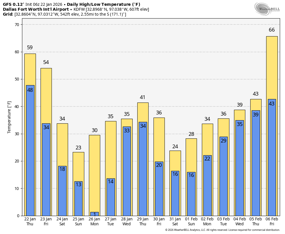
This is an Historical Winter Storm for everyone from I-10 North - several DFW Records maybe broken with this storm - Low Max and Low Min on Jan 25 & 26 along with the snowfall record on the 25th as well.
The latest GFS run over the next two weeks is incredible!
. Not sure why/where this narrative of a "bust" is coming from, everything looks to be on track...only question now is about timing of when the transition occurs. There looks to be 3 waves of precip with this system. It's only the front end batch (Friday/Friday Night) that is in question on when the transition from liquid to frz occurs. But overall, all 3 waves have a substantial amount of QPF occupying them.
This is an Historical Winter Storm for everyone from I-10 North - several DFW Records maybe broken with this storm - Low Max and Low Min on Jan 25 & 26 along with the snowfall record on the 25th as well.
The latest GFS run over the next two weeks is incredible!
7 likes
-
rwfromkansas
- Category 5

- Posts: 2883
- Joined: Sat Aug 27, 2005 12:47 am
- Location: North Fort Worth
-
TeamPlayersBlue

- Category 5
- Posts: 3519
- Joined: Tue Feb 02, 2010 1:44 am
- Location: Denver/Applewood, CO
Re: Texas Winter 2025-2026
Gotwood wrote:I mean if this is true Arctic air I can easily seeing those temps now being forecast to bust on Friday. Lots to see play out.
So i agree. Partially. I agree in a sense of how can a 1052 HP in the US not produce below freezing temps to the Gulf Coast. At the same time, the winds are shunting things to the east and i believe alot of the cold will go with it.
1 likes
Personal Forecast Disclaimer:
The posts in this forum are NOT official forecast and should not be used as such. They are just the opinion of the poster and may or may not be backed by sound meteorological data. They are NOT endorsed by any professional institution or storm2k.org. For official information, please refer to the NHC and NWS products.
The posts in this forum are NOT official forecast and should not be used as such. They are just the opinion of the poster and may or may not be backed by sound meteorological data. They are NOT endorsed by any professional institution or storm2k.org. For official information, please refer to the NHC and NWS products.
Re: Texas Winter 2025-2026
I think an ICON/GFS/RGEM blend is probably the way to go for temps. Initially it may be a little slow to transition the freeze line quickly but Saturday afternoon and evening once CAA is going strong it will fall very quickly into the lower 20s and teens across I-20. I'm not buying the Euro/NAM couplet yet, I've seen surface temps fail with these blasts we've gone through this many times already with those especially the Euro.
3 likes
The above post and any post by Ntxw is NOT an official forecast and should not be used as such. It is just the opinion of the poster and may or may not be backed by sound meteorological data. It is NOT endorsed by any professional institution including Storm2k. For official information, please refer to NWS products.
Help support Storm2K!
Help support Storm2K!
Re: Texas Winter 2025-2026
TeamPlayersBlue wrote:Gotwood wrote:I mean if this is true Arctic air I can easily seeing those temps now being forecast to bust on Friday. Lots to see play out.
So i agree. Partially. I agree in a sense of how can a 1052 HP in the US not produce below freezing temps to the Gulf Coast. At the same time, the winds are shunting things to the east and i believe alot of the cold will go with it.
This is the disconnect between the upper flow and surface. Back in 2023 every model (global) led by the Euro was pretty good with the upper flow but struggled with lower level cold, myself, txtwister, and orangeblood had to go against the world because the Euro was mild only to see one of the worse freezing rain icing events in ATX and SAT. If you have a trough that digs into the southwest it allows the cold to bleed. This splitting of the upper flow it has to pick one or the other and often times it is the model that picks the broader cold trough northeast vs the western flank.
3 likes
The above post and any post by Ntxw is NOT an official forecast and should not be used as such. It is just the opinion of the poster and may or may not be backed by sound meteorological data. It is NOT endorsed by any professional institution including Storm2k. For official information, please refer to NWS products.
Help support Storm2K!
Help support Storm2K!
Re: Texas Winter 2025-2026
orangeblood wrote:This board is wild
There looks to be 3 waves of precip with this system. It's only the front end batch (Friday/Friday Night) that is in question on when the transition from liquid to frz occurs. But overall, all 3 waves have a substantial amount of QPF occupying them.
This is an Historical Winter Storm for everyone from I-10 North - several DFW Records maybe broken with this storm - Low Max and Low Min on Jan 25 & 26 along with the snowfall record on the 25th as well.
The latest GFS run over the next two weeks is incredible!
Incredible but the real winter fun begins second week of Feb.


4 likes
The above post and any post by Ntxw is NOT an official forecast and should not be used as such. It is just the opinion of the poster and may or may not be backed by sound meteorological data. It is NOT endorsed by any professional institution including Storm2k. For official information, please refer to NWS products.
Help support Storm2K!
Help support Storm2K!
-
rwfromkansas
- Category 5
- Posts: 2883
- Joined: Sat Aug 27, 2005 12:47 am
- Location: North Fort Worth
Re: Texas Winter 2025-2026
Ntxw wrote:orangeblood wrote:This board is wild
There looks to be 3 waves of precip with this system. It's only the front end batch (Friday/Friday Night) that is in question on when the transition from liquid to frz occurs. But overall, all 3 waves have a substantial amount of QPF occupying them.
This is an Historical Winter Storm for everyone from I-10 North - several DFW Records maybe broken with this storm - Low Max and Low Min on Jan 25 & 26 along with the snowfall record on the 25th as well.
The latest GFS run over the next two weeks is incredible!
Incredible but the real winter fun begins second week of Feb.
https://i.imgur.com/0NlE9BI.png
I love that. Slightly west but far enough east stuff can build here which is rare.
1 likes
-
wxman22

- Category 5
- Posts: 1776
- Joined: Mon Jan 30, 2006 12:39 am
- Location: Wichita Falls, TX
- Contact:
Re: Texas Winter 2025-2026
12Z HRRR is in. The Euro also shows some very heavy snow up here. The topography of NW Texas helps in these shallow air setups.


Last edited by wxman22 on Thu Jan 22, 2026 9:20 am, edited 1 time in total.
3 likes
-
Brent
- S2K Supporter
- Posts: 38602
- Age: 37
- Joined: Sun May 16, 2004 10:30 pm
- Location: Tulsa Oklahoma
- Contact:
Re: Texas Winter 2025-2026
wxman22 wrote:12Z HRRR is in.
https://i.ibb.co/sv0F8ckh/CODNEXLAB-FORECAST-2026012212-HRRR-SGP-winter-ptype-34-100.gif
Yeah I'm seeing more and more people buying the historic totals
1 likes
#neversummer
-
Captmorg70
- Tropical Storm

- Posts: 182
- Age: 38
- Joined: Mon Dec 18, 2017 12:07 am
- Location: Ponder Tx
Re: Texas Winter 2025-2026
Just to put everything into perspective as we go into the 12z suite of models.
The “busts” and warmer temps for DFW and North Texas do not mean nothing is going to happen and it will be cold rain. This will still be a significant winter storm. Currently it looks to have multiple inches of sleet and snow before this all said and done.
This is much different than most winter storm setups for us. A lot of places will see over 2” of qpf which is wild. We’re not talking about a marginal setup and hopping to squeeze out an inch of snow if lucky. It will all come down to the cold air at the surface and aloft.
4 likes
-
HockeyTx82
- S2K Supporter
- Posts: 2709
- Joined: Tue Oct 27, 2009 11:17 am
- Location: Ponder, TX
Re: Texas Winter 2025-2026
Okay so who is taking point on tracking the front and also posting if it's ahead of schedule or not based off of model guidance?
Buckle up we're less than 48 hours away from Showtime......

Buckle up we're less than 48 hours away from Showtime......
2 likes
Don't hold me accountable for anything I post on this forum. Leave the real forecasting up to the professionals.
Location: Ponder, TX (all observation posts are this location unless otherwise noted)
Location: Ponder, TX (all observation posts are this location unless otherwise noted)
Who is online
Users browsing this forum: A1A, BigB0882, bigddstranny, BradKingK, Brazoria979cnty, Brent, cajungal, Captmorg70, Cdenton12, cheezyWXguy, chickypez, Cpv17, cstrunk, downsouthman1, foulbeast, gboudx, GeauxTigers, Gotwood, GunnySgtGandalf, Haddox12, Harp.1, HockeyTx82, Iceresistance, Jag95, JDawg512, jg5894, Kingarabian, KirbyDude25, Ntxw, orangeblood, Portastorm, Ralph's Weather, rwfromkansas, Sambucol2024, South Texas Storms, Stratton23, Tireman4, TomballEd, TropicalTundra, utpmg, UTSARoadrunner4, WacoWx, WaveBreaking, WeatherP1, Yukon Cornelius and 483 guests