Deep South Winter 2024-2025-2026

Winter Weather Discussion

Moderator: S2k Moderators

Forum rules

The posts in this forum are NOT official forecast and should not be used as such. They are just the opinion of the poster and may or may not be backed by sound meteorological data. They are NOT endorsed by any professional institution or STORM2K.

Help Support Storm2K
Message
Author
User avatar
Nimbus
Category 5
Category 5
Posts: 5450
Joined: Mon Jul 19, 2004 10:54 am

Re: Deep South Winter 2024-2025-2026

#981 Postby Nimbus » Mon Jan 26, 2026 5:43 pm

Kingarabian wrote:Seeing some hints on the models for snow this weekend in eastern NC. Some models show it in relation to the gulf system while some others dont.


12Z Euro has a 963 mb low in the same area as that GFS 18Z run with the 959 mb super storm but the track is further offshore not over Long Island this run. So it wasn't a pure GFS fantasy. The Polar vortex has a passing lobe that could kink the jet stream a little more than we are projecting 6 days out. I just hope we don't get ghosted in the last 36 hours with a major shift that surprises everyone in emergency planning. For example we've got cold air at the surface from the first frontal passage and ice takes out power fast and you can't plow it.
0 likes   

3090
Category 2
Category 2
Posts: 553
Age: 66
Joined: Fri Aug 19, 2011 4:01 pm

Re: Deep South Winter 2024-2025-2026

#982 Postby 3090 » Mon Jan 26, 2026 5:51 pm

Nimbus wrote:
Kingarabian wrote:Seeing some hints on the models for snow this weekend in eastern NC. Some models show it in relation to the gulf system while some others dont.


12Z Euro has a 963 mb low in the same area as that GFS 18Z run with the 959 mb super storm but the track is further offshore not over Long Island this run. So it wasn't a pure GFS fantasy. The Polar vortex has a passing lobe that could kink the jet stream a little more than we are projecting 6 days out. I just hope we don't get ghosted in the last 36 hours with a major shift that surprises everyone in emergency planning. For example we've got cold air at the surface from the first frontal passage and ice takes out power fast and you can't plow it.

Are we talking along the gulf coast here?
1 likes   

Jag95
Category 1
Category 1
Posts: 492
Joined: Sat Aug 15, 2009 8:43 pm
Location: Mobile, AL

Re: Deep South Winter 2024-2025-2026

#983 Postby Jag95 » Mon Jan 26, 2026 5:58 pm

The Canadian is showing some 30kt winds and Gulf effect precip on Saturday. Wouldn't be surprising to see some flurries north of Tampa if that was to verify. The 18Z GFS still suppressed.

<edit> Also, the Canadian shows it at 955 mbs off the NE coast.
0 likes   

User avatar
Kingarabian
S2K Supporter
S2K Supporter
Posts: 16329
Joined: Sat Aug 08, 2009 3:06 am
Location: Honolulu, Hawaii

Re: Deep South Winter 2024-2025-2026

#984 Postby Kingarabian » Mon Jan 26, 2026 6:18 pm

Nimbus wrote:
Kingarabian wrote:Seeing some hints on the models for snow this weekend in eastern NC. Some models show it in relation to the gulf system while some others dont.


12Z Euro has a 963 mb low in the same area as that GFS 18Z run with the 959 mb super storm but the track is further offshore not over Long Island this run. So it wasn't a pure GFS fantasy. The Polar vortex has a passing lobe that could kink the jet stream a little more than we are projecting 6 days out. I just hope we don't get ghosted in the last 36 hours with a major shift that surprises everyone in emergency planning. For example we've got cold air at the surface from the first frontal passage and ice takes out power fast and you can't plow it.

That's unfortunately likely to be the case here. But I think will come down to the gulf low's strength and just how close it is to the gulf coast over the next 48 hrs. Euro/CMC/ICON are in pretty good agreement on the low being close to the coast. GFS has the low farther away from the gulf coast.
0 likes   
RIP Kobe Bryant

TallyTracker
Category 2
Category 2
Posts: 784
Joined: Thu Oct 11, 2018 2:46 pm

Re: Deep South Winter 2024-2025-2026

#985 Postby TallyTracker » Mon Jan 26, 2026 7:06 pm

I remember a decent signal for snow and ice along the Gulf Coast about a week out for last year’s snowstorm. The signal did wax and wane a little, but generally it got stronger as the week progressed.

This storm does not appear to have quite the same strength of signal nor the consistency on the models. It’s still possible, but anything more than flurries is definitely an outlier outcome at this time.
0 likes   
Fran '96, Georges '98, Gordon '00, Gabrielle '01, Charley '04, Frances '04, Jeanne '04, Barry '07, Fay '08, Debby '12, Matthew '16, Emily '17, Irma '17, Michael ‘18, Elsa ‘21, Fred ‘21, Mindy ‘21, Nicole ‘22, Idalia ‘23, Debby ‘24, Helene ‘24

User avatar
Nimbus
Category 5
Category 5
Posts: 5450
Joined: Mon Jul 19, 2004 10:54 am

Re: Deep South Winter 2024-2025-2026

#986 Postby Nimbus » Mon Jan 26, 2026 7:47 pm

3090 wrote:
Nimbus wrote:
Kingarabian wrote:Seeing some hints on the models for snow this weekend in eastern NC. Some models show it in relation to the gulf system while some others dont.


12Z Euro has a 963 mb low in the same area as that GFS 18Z run with the 959 mb super storm but the track is further offshore not over Long Island this run. So it wasn't a pure GFS fantasy. The Polar vortex has a passing lobe that could kink the jet stream a little more than we are projecting 6 days out. I just hope we don't get ghosted in the last 36 hours with a major shift that surprises everyone in emergency planning. For example we've got cold air at the surface from the first frontal passage and ice takes out power fast and you can't plow it.

Are we talking along the gulf coast here?


Freezing rain line is in the vicinity of the coast with some model runs. Wind out of the NW keeps the warmer gulf from moderating the land surface temps. Also the potential for blizzard conditions in the NE if this system bombs into the 950's and hugs the coast .
1 likes   

Jag95
Category 1
Category 1
Posts: 492
Joined: Sat Aug 15, 2009 8:43 pm
Location: Mobile, AL

Re: Deep South Winter 2024-2025-2026

#987 Postby Jag95 » Mon Jan 26, 2026 8:01 pm

TallyTracker wrote:I remember a decent signal for snow and ice along the Gulf Coast about a week out for last year’s snowstorm. The signal did wax and wane a little, but generally it got stronger as the week progressed.

This storm does not appear to have quite the same strength of signal nor the consistency on the models. It’s still possible, but anything more than flurries is definitely an outlier outcome at this time.


True. Even the ones showing a more northerly path are lacking on timing. The models would have to majorly change for anything on the northern GOM. And my 72-hr window for believing is fast approaching.

But, I think the FL upper west coast has a good chance for flurries or even light snow. The Canadian sounding shows snow around Tampa Saturday night, and even the Euro is marginal. IF they don't change again.
0 likes   

User avatar
Kingarabian
S2K Supporter
S2K Supporter
Posts: 16329
Joined: Sat Aug 08, 2009 3:06 am
Location: Honolulu, Hawaii

Re: Deep South Winter 2024-2025-2026

#988 Postby Kingarabian » Mon Jan 26, 2026 8:58 pm

I agree the gulf coast signal is weaker than last years. Still pretty legit right now for SC/NC. All the models show that cut off low too btw.
0 likes   
RIP Kobe Bryant

User avatar
MississippiWx
S2K Supporter
S2K Supporter
Posts: 1720
Joined: Sat Aug 14, 2010 1:44 pm
Location: Hattiesburg, Mississippi

Re: Deep South Winter 2024-2025-2026

#989 Postby MississippiWx » Mon Jan 26, 2026 10:37 pm

The ensembles showing a wetter system just isn’t carrying over to the operational models. We had a slight uptick earlier today, but the disturbances are just too out of sync. Likely just very dry cold coming in this weekend for the Gulf States. Some lucky areas may get some passing snow showers on the north side of any precip that falls, but that’s about the extent of it. Bring on spring. Dry cold sucks.
2 likes   
This post is not an official forecast and should not be used as such. It is just the opinion of MississippiWx and may or may not be backed by sound meteorological data. It is not endorsed by any professional institution including storm2k.org. For Official Information please refer to the NHC and NWS products.

User avatar
Ivanhater
Storm2k Moderator
Storm2k Moderator
Posts: 11221
Age: 39
Joined: Fri Jul 01, 2005 8:25 am
Location: Pensacola

Re: Deep South Winter 2024-2025-2026

#990 Postby Ivanhater » Tue Jan 27, 2026 5:59 am

MississippiWx wrote:The ensembles showing a wetter system just isn’t carrying over to the operational models. We had a slight uptick earlier today, but the disturbances are just too out of sync. Likely just very dry cold coming in this weekend for the Gulf States. Some lucky areas may get some passing snow showers on the north side of any precip that falls, but that’s about the extent of it. Bring on spring. Dry cold sucks.


Yeah. With the high struggling to get above freezing Saturday, I'm ready for 80s ASAP
1 likes   
Michael

User avatar
Nimbus
Category 5
Category 5
Posts: 5450
Joined: Mon Jul 19, 2004 10:54 am

Re: Deep South Winter 2024-2025-2026

#991 Postby Nimbus » Tue Jan 27, 2026 8:01 am

MississippiWx wrote:The ensembles showing a wetter system just isn’t carrying over to the operational models. We had a slight uptick earlier today, but the disturbances are just too out of sync. Likely just very dry cold coming in this weekend for the Gulf States. Some lucky areas may get some passing snow showers on the north side of any precip that falls, but that’s about the extent of it. Bring on spring. Dry cold sucks.


The latest Tue morning model runs are not showing a closed off moisture pumping low in the gulf.
Cold northwest wind will spike power demand for heating in the south but maybe no ice :cold:
1 likes   

User avatar
Kingarabian
S2K Supporter
S2K Supporter
Posts: 16329
Joined: Sat Aug 08, 2009 3:06 am
Location: Honolulu, Hawaii

Re: Deep South Winter 2024-2025-2026

#992 Postby Kingarabian » Tue Jan 27, 2026 8:58 am

GFS and Euro seem to have switched in regards to the strength of the gulf low and how much moisture it'll provide. Not surprising.
0 likes   
RIP Kobe Bryant

User avatar
Steve
S2K Supporter
S2K Supporter
Posts: 9670
Joined: Sat Apr 05, 2003 11:41 pm
Location: NOLA/PCOLA

Re: Deep South Winter 2024-2025-2026

#993 Postby Steve » Tue Jan 27, 2026 9:36 am

It's cold this morning.
0 likes   

BigB0882
S2K Supporter
S2K Supporter
Posts: 2290
Joined: Thu Jul 03, 2003 12:08 am
Location: Baton Rouge, LA
Contact:

Re: Deep South Winter 2024-2025-2026

#994 Postby BigB0882 » Tue Jan 27, 2026 11:21 am

Steve wrote:It's cold this morning.


Sure is. It was down to 19 IMBY and I live south of I-10 (just barely) so that's quite rare. Hasn't been this cold since the big snowstorm last year when we bottomed out in the single digits.
0 likes   

3090
Category 2
Category 2
Posts: 553
Age: 66
Joined: Fri Aug 19, 2011 4:01 pm

Re: Deep South Winter 2024-2025-2026

#995 Postby 3090 » Tue Jan 27, 2026 12:55 pm

Kingarabian wrote:GFS and Euro seem to have switched in regards to the strength of the gulf low and how much moisture it'll provide. Not surprising.

What does this or may mean for the gulf coast now? Thanks!
0 likes   

User avatar
Kingarabian
S2K Supporter
S2K Supporter
Posts: 16329
Joined: Sat Aug 08, 2009 3:06 am
Location: Honolulu, Hawaii

Re: Deep South Winter 2024-2025-2026

#996 Postby Kingarabian » Tue Jan 27, 2026 1:09 pm

3090 wrote:
Kingarabian wrote:GFS and Euro seem to have switched in regards to the strength of the gulf low and how much moisture it'll provide. Not surprising.

What does this or may mean for the gulf coast now? Thanks!

In terms of the gulf coast it looks about the same as previous runs with minimal winter weather. GFS still has winter impacts for some parts of GA/SC/NC.
0 likes   
RIP Kobe Bryant

User avatar
Kingarabian
S2K Supporter
S2K Supporter
Posts: 16329
Joined: Sat Aug 08, 2009 3:06 am
Location: Honolulu, Hawaii

Re: Deep South Winter 2024-2025-2026

#997 Postby Kingarabian » Tue Jan 27, 2026 7:45 pm

12z/18z models with good agreement across the board for snowfall in northern parts of GA and SC/NC.
0 likes   
RIP Kobe Bryant

Powellrm
Tropical Storm
Tropical Storm
Posts: 115
Joined: Sun Sep 03, 2017 1:40 pm

Re: Deep South Winter 2024-2025-2026

#998 Postby Powellrm » Tue Jan 27, 2026 9:19 pm

Kingarabian wrote:12z/18z models with good agreement across the board for snowfall in northern parts of GA and SC/NC.


Only with ICON being the outlier. ICON tends to pick up on trends early and stick to its guns. I’m keeping my eye on what the ICON does in the next 24 hours. It’s keeping the low well off the NC coast.
1 likes   

User avatar
Kingarabian
S2K Supporter
S2K Supporter
Posts: 16329
Joined: Sat Aug 08, 2009 3:06 am
Location: Honolulu, Hawaii

Re: Deep South Winter 2024-2025-2026

#999 Postby Kingarabian » Tue Jan 27, 2026 11:22 pm

Powellrm wrote:
Kingarabian wrote:12z/18z models with good agreement across the board for snowfall in northern parts of GA and SC/NC.


Only with ICON being the outlier. ICON tends to pick up on trends early and stick to its guns. I’m keeping my eye on what the ICON does in the next 24 hours. It’s keeping the low well off the NC coast.

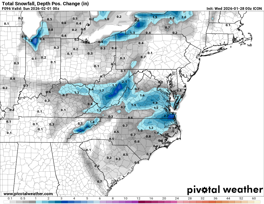
ICON is the driest out of the bunch but still manages to dump 0.5 to 3 inches of snow, close to Savannah to eastern NC.

Image
0 likes   
RIP Kobe Bryant

Powellrm
Tropical Storm
Tropical Storm
Posts: 115
Joined: Sun Sep 03, 2017 1:40 pm

Re: Deep South Winter 2024-2025-2026

#1000 Postby Powellrm » Wed Jan 28, 2026 9:19 am

Kingarabian wrote:
Powellrm wrote:
Kingarabian wrote:12z/18z models with good agreement across the board for snowfall in northern parts of GA and SC/NC.


Only with ICON being the outlier. ICON tends to pick up on trends early and stick to its guns. I’m keeping my eye on what the ICON does in the next 24 hours. It’s keeping the low well off the NC coast.


Looks like ICON has indeed shifted towards towards the consensus output of the other models. Will check again this evening.
ICON is the driest out of the bunch but still manages to dump 0.5 to 3 inches of snow, close to Savannah to eastern NC.

https://i.postimg.cc/mgWQFybF/snodpc-acc-imp-us-ma.png
1 likes   


Return to “Winter Weather”

Who is online

Users browsing this forum: 869MB, AnnularCane, Brent, cheezyWXguy, DonWrk, Harp.1, HurricaneBelle, Kasenaff7, Kingarabian, opticsguy, rmic, rylo7956, Stratton23, Texas Snowman and 100 guests